

|
What's available |
Title |
Remarks |
|
|
The South- Download Created 27th May, 2024 NEW - |
On 25th May, 2024 we conducted a survey of the SW Sunk swatchway. Conditions were good with light 5 to 8 kts winds and good visibility. We collected data for just short of 4 hours and the chartlet is created using Surfer software and 13507 soundings. There is a little change with the SW Sunk knoll continuing to advance to the North. The advance over the past winter has been about 100 metres so I have adjusted the west and central waypoints. The central waypoint has been moved north to distance it from the knoll and any tide effect. On a flood tide a tide rip runs in front of the north and north- Depths remain very good and with a comfortable width. |
|
|
The Spitway NEW - Re- |
This is a CTTE chartlet based upon resurvey on 25th June 2024. Compared to 2022 there has been a little loss of depth especially on a line between the Safe Water Buoys. Best water remains to the east of the Safe Water Buoys. Note that NtM 3316/2024 has added a second wreck at the Spitway and that is included in the download. |
|
|
The Knoll NEW - Surveyed September, 2024 following NtM 4208 in week 37 (wc 02- For Readers: a replacement image for Page 44 can be downloaded below here: For Readers: NtM 4414(P)/24 referenced in the Consolidated Update of 21st September, 2024 can be downloaded here: |
This is a CTTE chartlet following a survey on 7th September, 2024. Ideal conditions with 70787 soundings. The Knoll is on the south side of the entrance to the River Blackwater and is marked by the NW Knoll PHB. The Knoll has always been there but over the years the drying part has moved. There has been no survey in that area since 1985 so UKHO charts (and all that following it) are out of date. If heading to and from between the Spitway and the Blackwater care should be taken to follow the buoyage unless you are confident about the height of tide. On a windy day, especially on a spring tide, there can be some agitation there. |
|
|
Buoy changes at the Long Sand Head NEW May 2024 |
On 20th May, 2024 Trinity House have issued a Notice to Mariners confirming the completion of the changes at the Long Sand Head.. In the past 12 months, the Long Sand Head has continued gently, but persistently, to creep more to the northeast. For us there is no crisis but heed the warning not to ‘cut the corner’. For shipping using the Two- The changes are: The creation of a new east cardinal buoy. This will be positioned very close to current position of the Longsand Head north cardinal buoy. The new buoy will be designated ‘East Longsand Head’. Characteristics are shown in the chartlet. Note it will have AIS. The Longsand Head north cardinal buoy will be moved west and a little north. As you will see in the chartlet the effect is to make the corner clear for shipping. Characteristics for this buoy will remain as at present. |
|
|
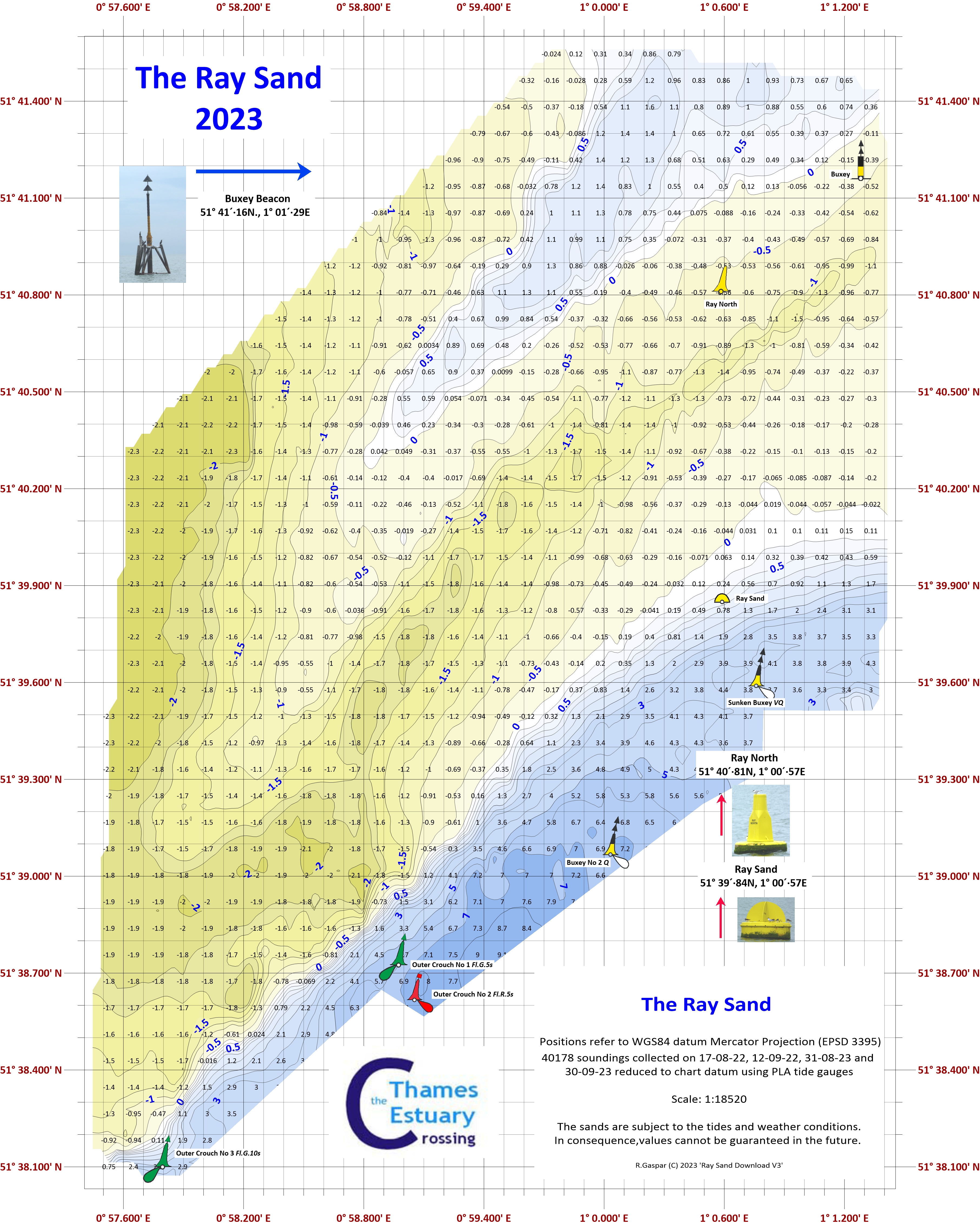
The Ray Sand NEW 2023 Revised Ray Sand buoyage July, 2023 Extended chartlet (east side) |
We completed two surveys in August and September and the new chartlet has available. However, 0n 13th July, the Crouch Harbour Authority notified changes to the Ray Sand buoyage. The Ray Sand buoy is re- The chartlet has been changed to reflect the buoyage. If wished, click on the image for the jpg version. |
|
|
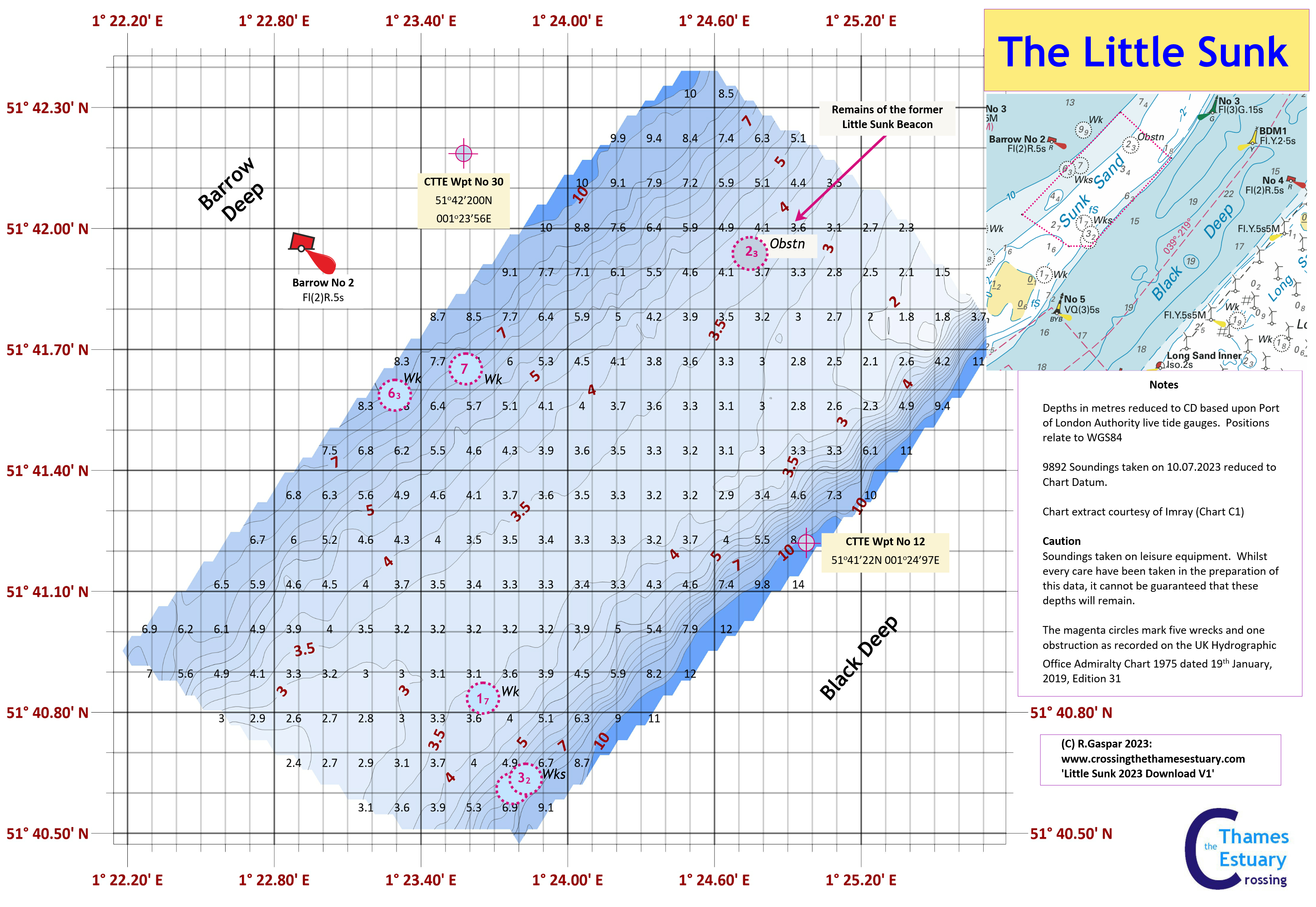
The Little Sunk Adjacent to the Barrow No 2 PHB NEW 2023 Surveyed on 10th July, 2023 |
This is a CTTE chartlet based upon a survey conducted on 10th July, 2023. The Little Sunk (discussed on Page 24, 3rd Edition) is is usually a stable crossing place and it remains so in 2023. Arguably it has lost 0.2m of depth but it has a controlling depth of 3.2m in the centre. The crossing area is bounded by two wrecks to the south- |
|
|
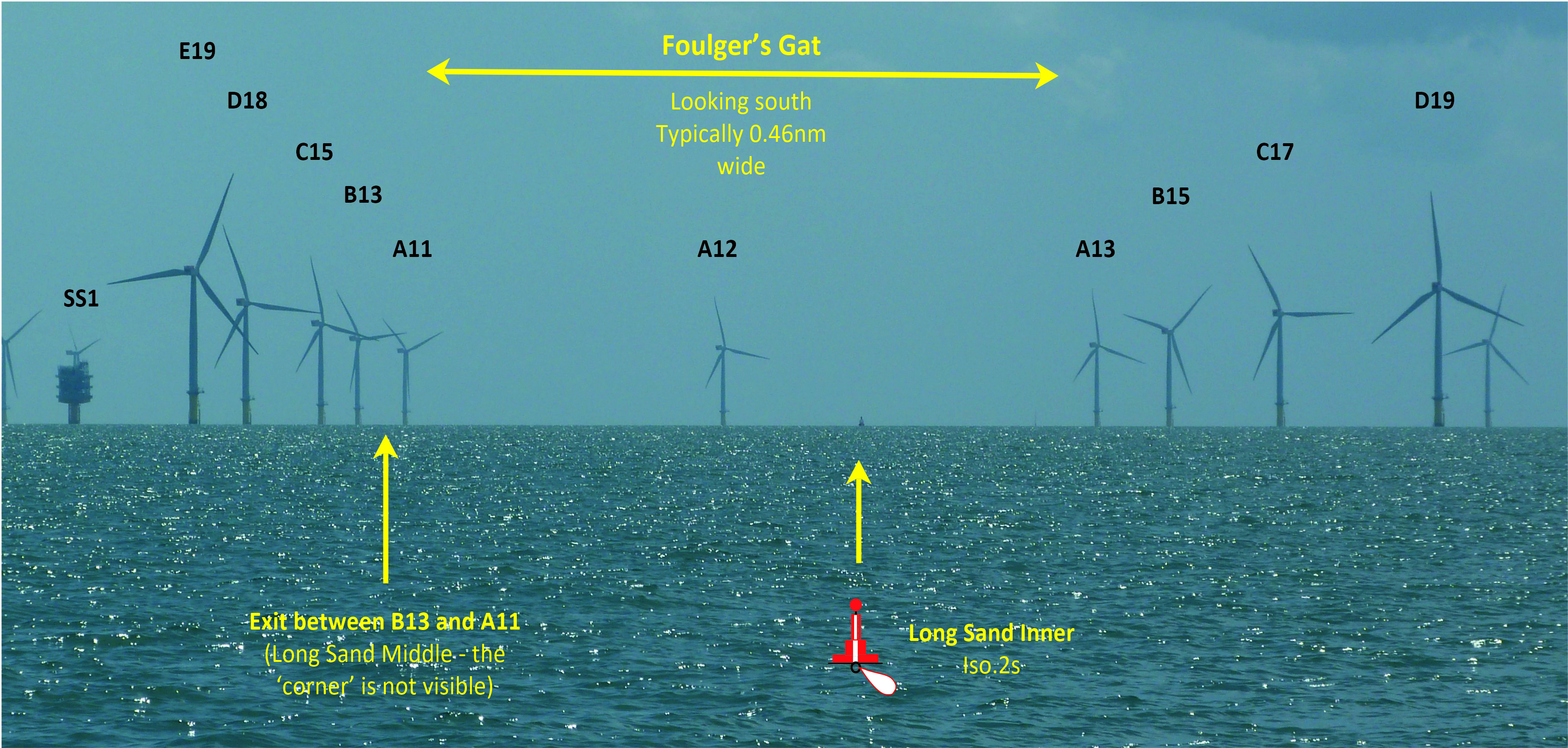
Foulger's Gat 2023 Click on the image to download the jpg. |
While we were ‘criss- For this image (and the technical), the camera is on the Little Sunk and was 3.067nM from the Long Sand Inner Safe Water Buoy, bearing 175°(T), Turbines A12 is 6.742nM from the camera. Obvious the Long Sand Middle could not be visible. The camera was pointed at 174°(T). |
|
|
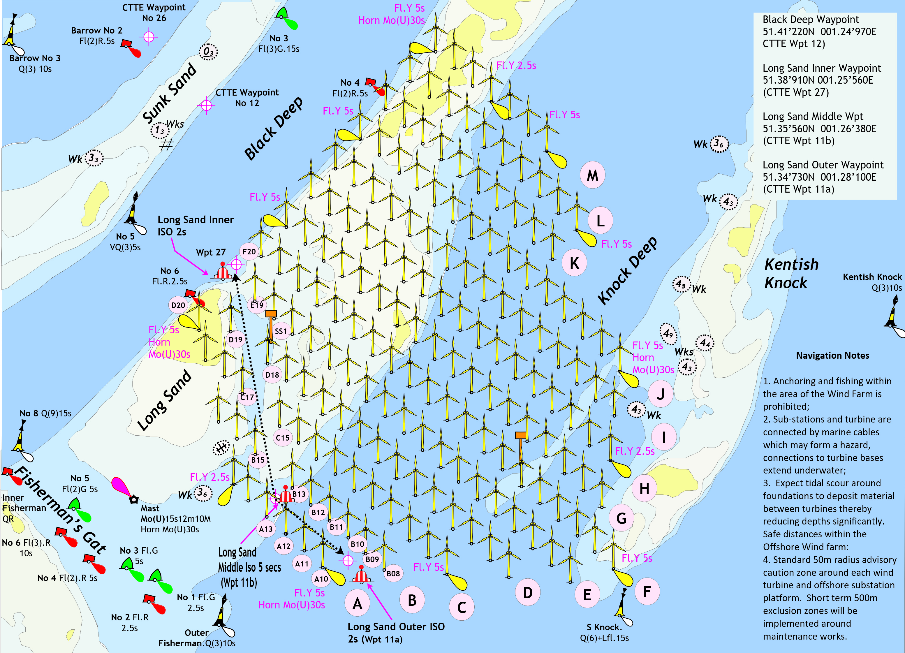
The London Array Wind Farm and Foulger's Gat Amended 28.01.2015 No subsequent changes up to July. 2023. |
This is CTTE’s image of the route through the London Array Windfarm . |
|
|
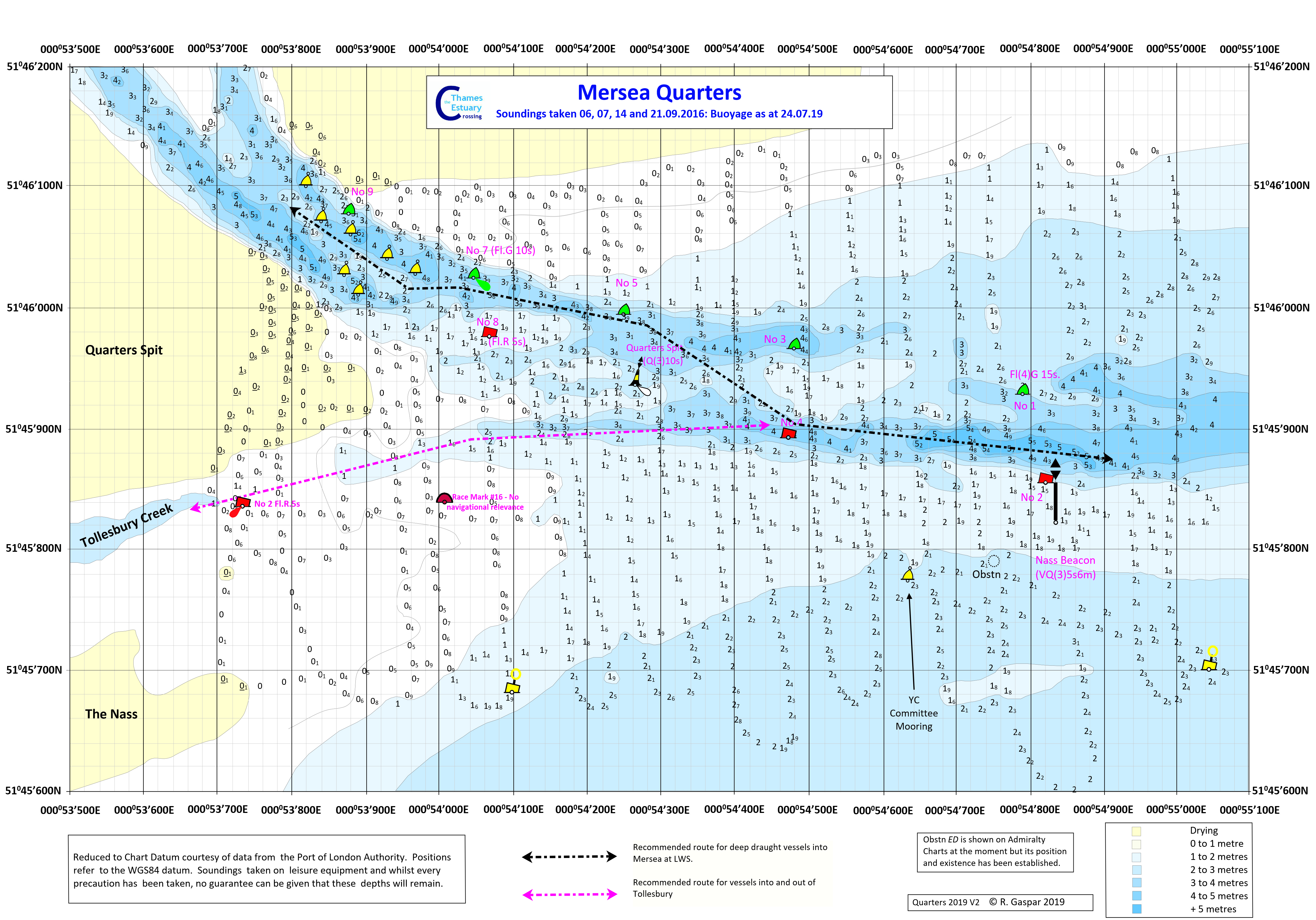
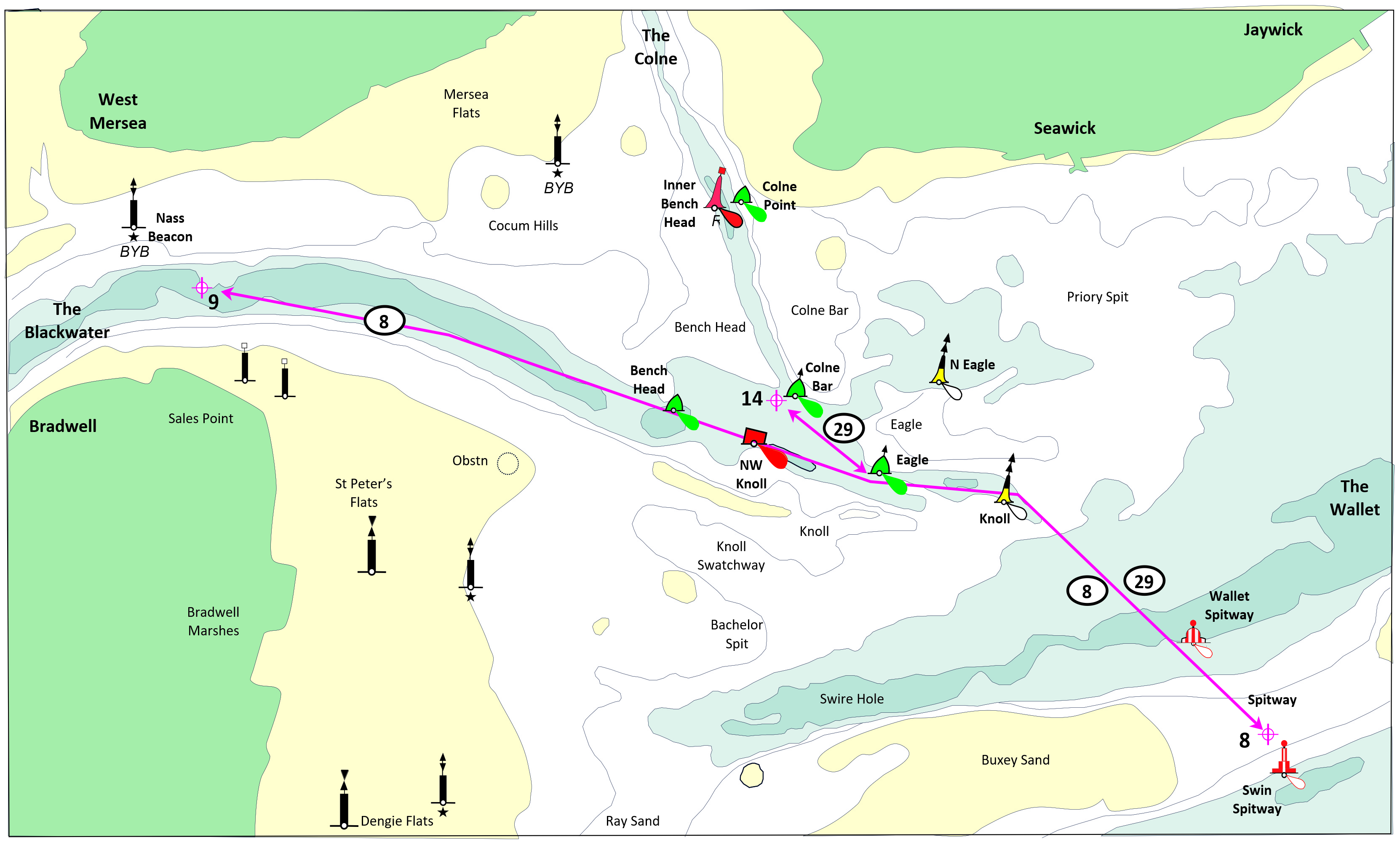
Mersea Quarters Buoyage as August, 2019 (Tollesbury No 4 now placed back) |
This is a CTTE chartlet based upon a survey completed during October, 2016. Changes to depth across the Quarters has required a change to the buoyage which was re- Deep draught yachts (i.e. @2m draught) is recommended to follow the suggested route at LWS. Note this has been amended this month (May) to show the 'Obstn' SW of the Nass Beacon is not now annotated as ED. It DOES exist and should be regarded as dangerous to leisure craft. |
|
|
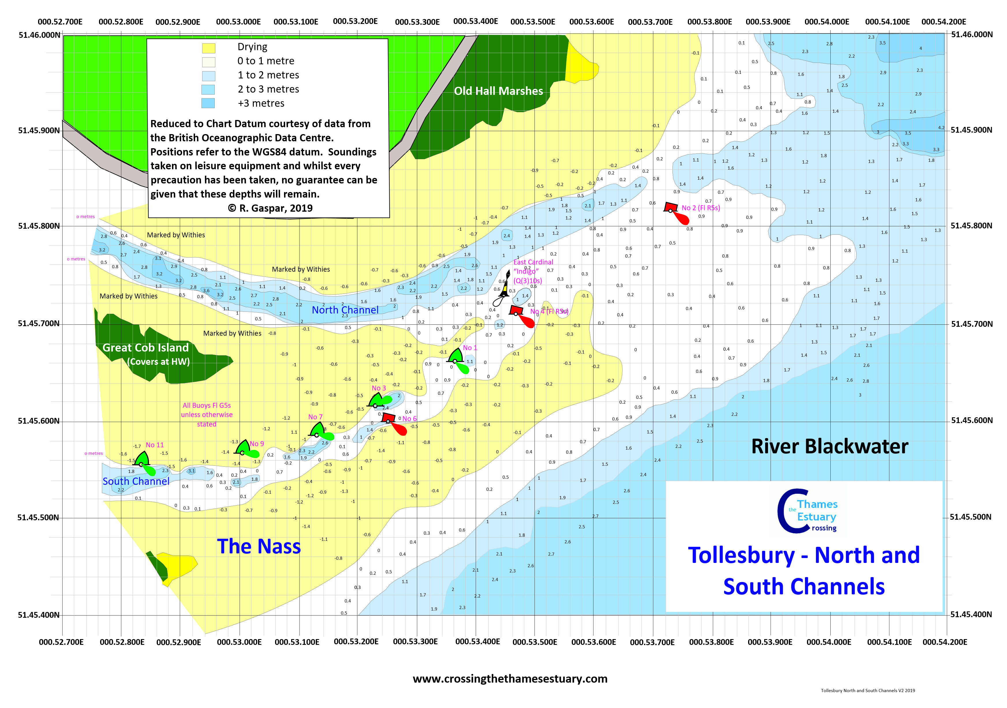
Tollesbury North and South Channels Revised (2) August, 2019 (Tollesbury No 4 now placed back) |
This is a CTTE Chartlet based upon surveys in 2011 and 2012. This includes the repositioning of buoys during 2019. |
|
|
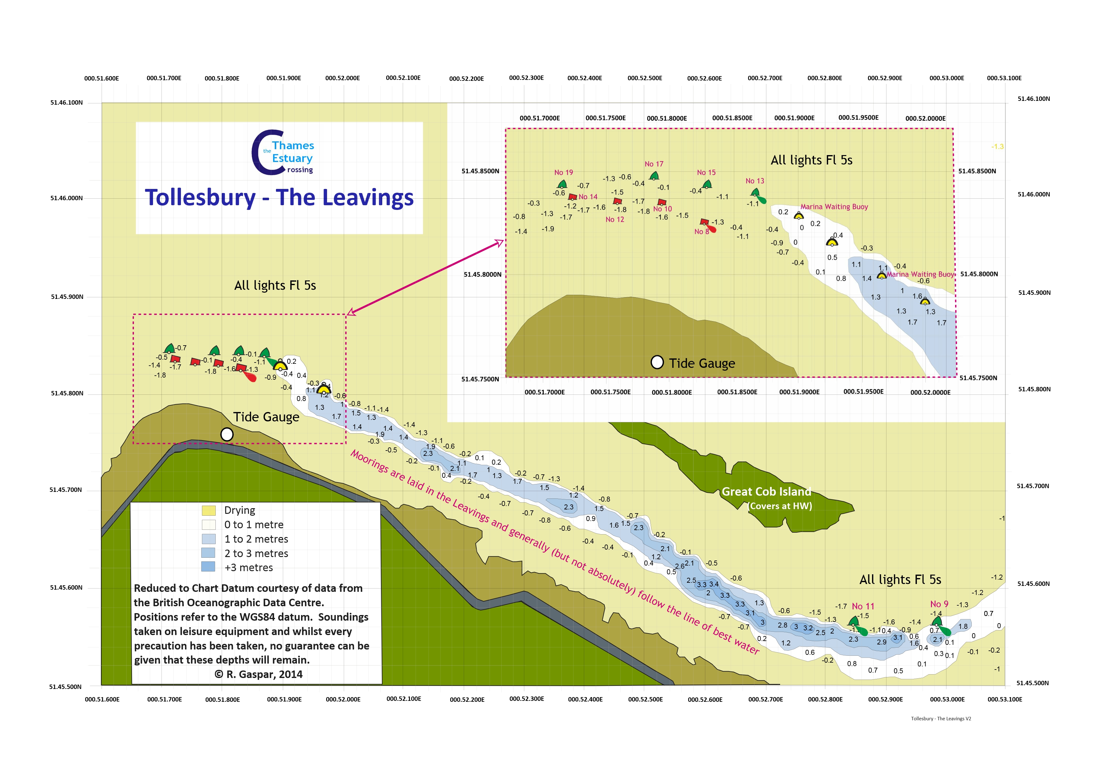
Tollesbury - Revised September, 2015 |
This is a CTTE Chartlet based upon surveys in 2011 and 2012 with corrections to 2015. |
|
|
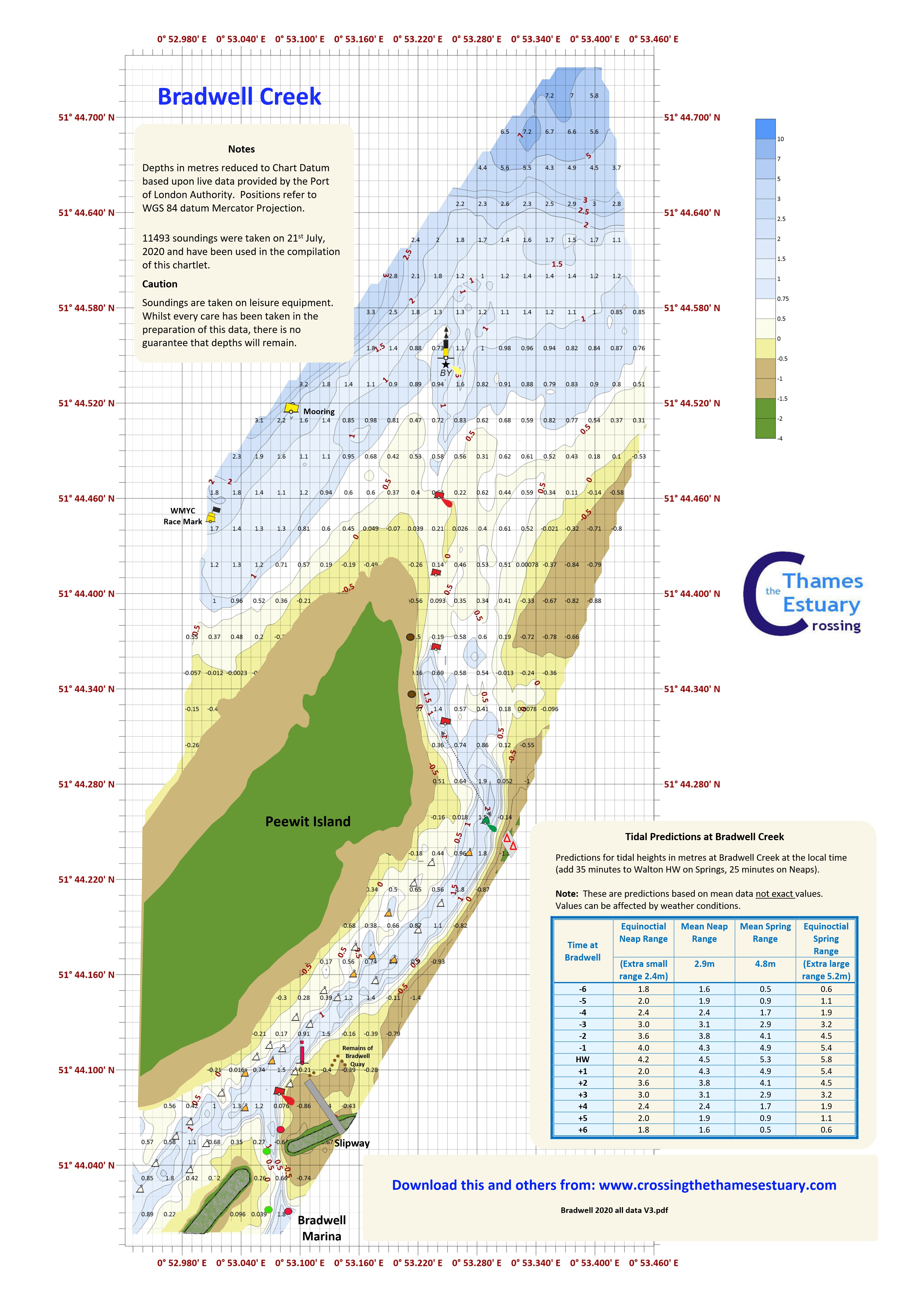
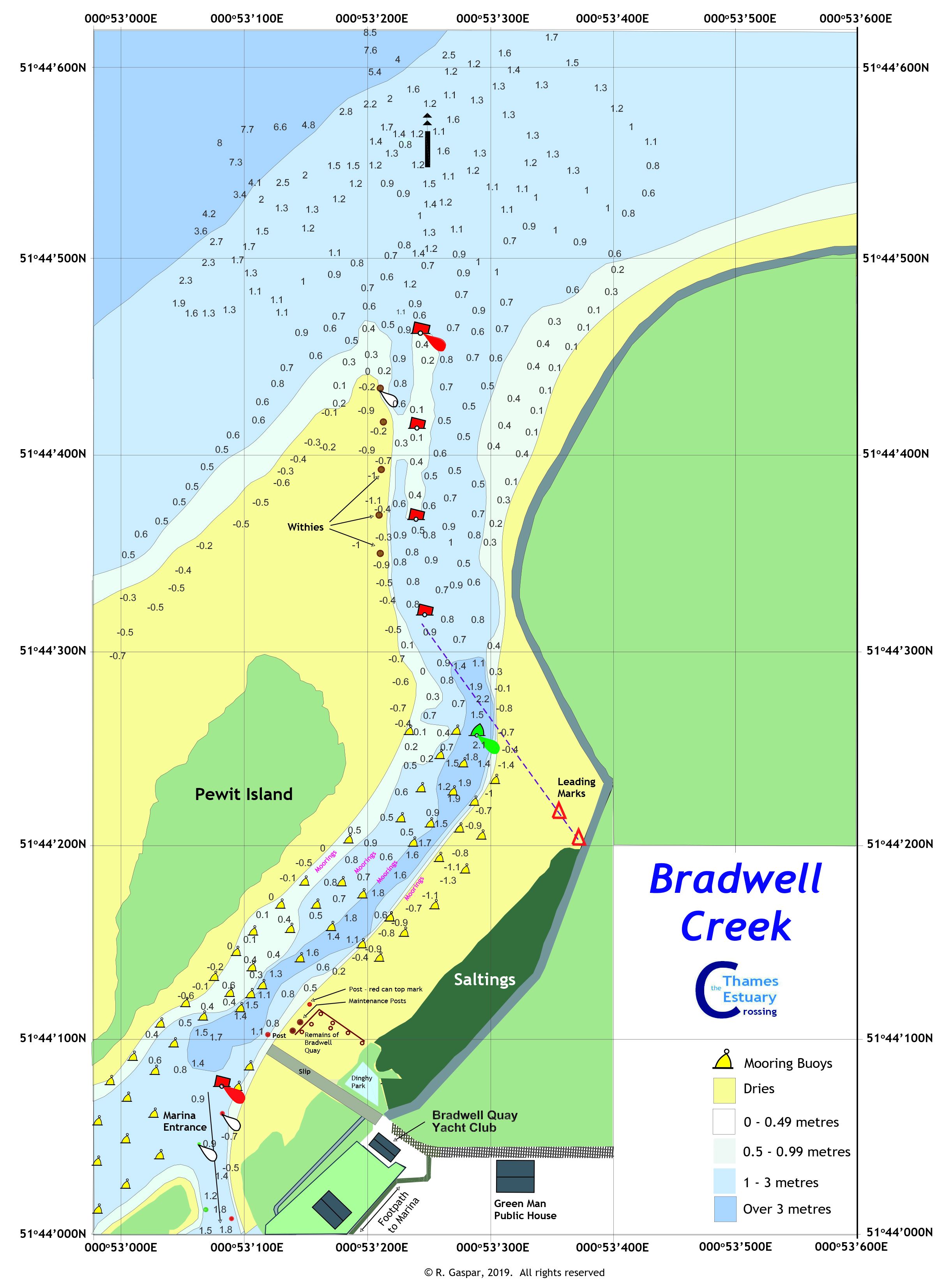
Bradwell Creek New chart 2020 |
Re- The chartlet is drawn to Chart Datum. I have just added a table of Tidal Height predictions at Bradwell Creek which I hope will assist new visitors. When printed the chartlet is best in A3 size. It is difficult to include all the detail in A4. None is omitted so it will be quite small. Of course as a PDF or JPG it can be enlarged as you wish. |
|
|
Lawling Creek Revised July, August and September, 2023 |
In the summer of 2023 we conducted a survey over three days collecting over 20,000 soundings. The CTTE chartlet is drawn at LWS and shows the full navigation buoyage and moorings laid by the Blackwater Marina. The inset shows the detail at the corner marked by the No 6 PHB. Note the 'twisting' corner to the final approach to the Marina. Click on the image for the jpg or the usual pdf button. |


| Bonus Supplement |
| The 'Odd' Videos |
| Notices to Mariners |
| Chart Corrections Links |
| Links to live data sites |