|
2021 Permanent/Temporary/Preliminary UKHO Notices to Mariners - |
||
|
Week 52 |
New Editions of ADMIRALTY Charts on 13th January, 2022 Chart 1606 - Chart 1607 - Chart 1609 - |
Includes changes to depths from the latest Port of London Authority and Trinity House Surveys. Includes changes to depths from the latest Trinity House and Port of London Authority Surveys. Includes changes to depths from the latest Port of London Authority and Peel Ports Medway Surveys. |
|
Week 52 |
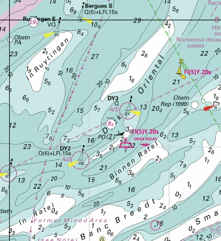
ENGLAND - Amend: fog signal to, Bell, at buoy 52° 01´·73N., 1° 38´·23E. Notice 5428 refers Base image courtesy of Imray ID10 Chart C28 and Meridian Chartware
|
Affects: UKHO Charts: 1610 and 2052 Imray Charts: C28 UKHO Small Craft Charts: 5607.5 and 5614.1 (Panel B, Orford Ness) The fog signal at the North Shipwash has been altered from ‘Whis’ to ‘Bell’.
|
|
Week 52 |
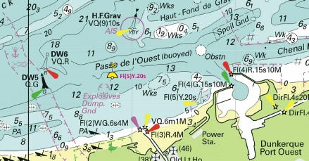
BELGIUM - Amend: light- light to, F.G.19m11M and fog signal, Horn Mo(U) at 51° 14´·44N., 2° 54´·97E. Notice 5483 refers Base image courtesy of Imray ID10 Chart 2120.3 and Meridian Chartware
|
Affects: UKHO Charts: 1872, 1873 (Panel A, Oostende), 1874 and 2449 Imray Charts: C30 Imray Leisure Folios: 2120.3 and 2120.3B Change of light characteristics at the Oostendebanke-
|
|
Week 51 |
New Editions of ADMIRALTY Charts published 6th January 2022 Chart 1534 - A Great Yarmouth Outer Harbour. 1:7,500 B Great Yarmouth Haven. 1:7,500 Chart 1535 - Lowestoft Harbour. 1:6,250 |
Includes changes to depths from the latest British Government and Trinity House surveys. Includes changes to depths from the latest British Government and Trinity House surveys. |
|
Week 51 |
ENGLAND - Insert: depth, 2.9 at 51° 19´·519N., 1° 24´·959E. Delete depth, 3.3, close W. depth, 3.9 at 51° 19´·507N., 1° 25´·270E. Delete depth, 4.5, close SW. depth, 3.4 at 51° 19´·498N., 1° 25´·424E. Delete depth, 4.1, close SW. depth, 4.1, and extend 5m contour SE to enclose 51° 19´·510N., 1° 25´·485E. Delete depth, 4.4, close W depth, 2.6 at 51° 19´·527N., 1° 25´·509E. Delete depth, 3, close SW. depth, 1.5, and extend 2m contour S to enclose 51° 19´·540N., 1° 25´·488E. Delete depth, 1.9, close N. depth, 2, enclosed by 2m contour at 51° 19´·778N., 1° 25´·214E. Delete depth, 2.5, close N. depth, 3.3 at 51° 19´·484N., 1° 25´·291E. Delete depth, 4.1, close N. depth, 3.1 at 51° 19´·488N., 1° 25´·363E. Delete depth, 3.9, close NE. depth, 3.6 at 1° 19´·500N., 1° 25´·134E. Delete depth 4.2, close SW. Replace: depth, 4.3, with depth, 3.7 at 51° 19´·511N., 1° 25´·056E. depth, 4.4, with depth, 3.8 at 51° 19´·548N., 1° 25´·071E. Delete: depth, 4.4 at 51° 19´·514N., 1° 25´·297E. depth, 3.7 at 51° 19´·484N., 1° 25´·342E. Notice 5424 refers Base image courtesy of Imray ID10 Chart C8F and Meridian Chartware
|
Affects: UKHO Charts: 1827 (Panel, Ramsgate), 1828 (Panel, Ramsgate) Imray Charts: C8F UKHO Small Craft Charts: 5605.15 (Panel B, Ramsgate) Imray Leisure Folios: 2100.11A Twelve reductions of depth in Ramsgate Harbour: eleven at the entrance and in the Outer Harbour and one in the Royal Harbour leading to the Inner Basin.
|
|
Week 50 |
ENGLAND - Insert: depth, 8.2 at 51° 27´·874N., 0° 17´·770E. Delete depth, 8.4, close N. depth, 8.3 at 51° 27´·555N., 0° 17´·468E. Delete depth, 8.9, close NW Notice 5165 refers Base image courtesy of Imray ID10 Chart C2 and Meridian Chartware
|
Affects: UKHO Charts: 2151 Imray Charts: C2 UKHO Small Craft Charts: 5606.14 Imray Leisure Folios: 2100.3B Two reduction of depth in Fiddler’s Reach, River Thames. Both are 8m+ so unlikely to hinder leisure craft.
|
|
Week 50 |
ENGLAND - For Chart 1183 Insert: drying height, 1.2, enclosed by 0m low water line at 51° 39´·97N., 1° 21´·62E. drying height, 0.3, enclosed by 0m low water line at 51° 38´·34N., 1° 18´·16E. drying height, 0.7, and extend 0m approximate low water line NE to enclose 51° 39´·73N., 1° 19´·00E. Delete depth, 4.2, close NE. drying height, 0.6, enclosed by 0m low water line at 51° 40´·22N., 1° 19´·29E. drying height, 0.8, enclosed by 0m low water line at 51° 40´·32N., 1° 19´·62E. Delete depth, 1.1, close S. depth, 0.9, enclosed by 2m contour at 51° 40´·55N., 1° 20´·27E. depth, 3.9, enclosed by 5m contour 51° 40´·60N., 1° 20´·85E. Delete depth, 8.9, close SW. For Chart 1975 Insert: the accompanying block, centred on: 51° 39´·8N., 1° 19´·7E. Notice 5173 refers The Block is copyright of the UKHO.
|
Affects: UKHO Charts: 1183 and 1975 Imray Charts: C1 UKHO Small Craft Charts: 5607.3 Imray Leisure Folios: 2100.1. 2000.1 This notice listed five new drying heights and two reduced soundings at the Middle Sunk (between the Barrow and Black Deeps). Chart 1183 needs individual annotation; Chart 1975 has a UKHO block (illustrated). This notice is the consequence of a 2015 Port of London Authority and an exploratory survey by CTTE. The result significantly updates the Middle Sunk crossing which shows a series of drying ‘knuckles’ on the ‘finger’ that extends north- The UKHO block also includes part of the SW Sunk swatchway. Current paper and electronic charts have not been updated since 2019 and they are therefore 600m out of position. You will see from the image taken of the UKHO block placed on Chart 1975, you will that it appears that the SW Sunk swatch is now recorded in the right place in the primary database. I am checking that the record has been updated and I will report back.
|
|
Week 50 |
BELGIUM - Delete:
Notice 5171 refers Base image courtesy of Imray ID10 Chart C2120.4 and Meridian Chartware
|
Affects: UKHO Charts: 1874 Imray Charts: C30 Imray Leisure Folios: 2120.4 Delete of the yellow Special buoy that was located very adjacent to the MOW4 beacon east of Zeebrugge for the in-
|
|
Week 50 |
NETHERLANDS - Insert: depth, 1, and extend 2m contour N to enclose 51° 38´·80N., 3° 35´·41E. Delete depth, 2.5, close NW. Notice 5175 refers Base image courtesy of Imray ID10 Chart C2120.6 and Meridian Chartware
|
Affects: UKHO Charts: 110 Imray Charts: C30 Imray Leisure Folios: 2120.6 One reduction of depth on the edge of the Oude Roompot channel which leads to the Oosterschelde.
|
|
Week 50 |
BELGIUM - Insert: legend, Buoyed (occas), centred on: 51° 07´·81N., 2° 33´·72E. Notice 5216 refers Base image courtesy of Imray ID10 Chart C2120.3 and Meridian Chartware
|
Affects: UKHO Charts: 1873 Imray Charts: C30 UKHO Small Craft Charts: 5607.3 Imray Leisure Folios: 2120.3 A new legend ‘Buoyed (occas)’ just north of the Trapegeer shoal west of Nieuwpoort.
|
|
Week 50 |
ENGLAND - The starboard- (ETRS89 DATUM) Notice 5226(T) refers Base image courtesy of Imray ID10 Chart C8D and Meridian Chartware
|
Affects: UKHO Charts: 1698 Imray Charts: C8D UKHO Small Craft Charts: 5605.14 Imray Leisure Folios: 2100.11C Temporary notice reporting a starboard hand buoy in the Outer Harbour of Dover is off station.
|
|
Week 50 |
ENGLAND - Delete:
Notice 5248 refers Base image courtesy of Imray ID10 Chart C8 and Meridian Chartware
|
Affects: UKHO Charts: 323, 1610, 2449 Imray Charts: C8 Imray Leisure Folios: 2100.7 Deletion of yellow Special buoy west of the NE Godwin (I think for diving purposes).
|
|
Week 50 |
NETHERLANDS - Insert: depth, 6.8 at 51° 26´·61N., 3° 33´·41E. Delete: sector at light, F.22m12M Sergeant at 51° 30´·28N., 3° 28´·41E. Notice 5241 refers Base image courtesy of Imray ID10 Chart C2120.3 and Meridian Chartware
|
Affects: UKHO Charts: 116 (Panel A Vlissingen), 116, 1874 Imray Charts: C30 Imray Leisure Folios: 2120.3 One reduction of depth (to 6.8m so unlikely to hinder leisure craft) at the southern entrance of the Oostgat channel on the Dutch coast. Also, deletion of a light sector at the ‘Sergeant’ on the coast of the Oostgat channel.
|
|
Week 49 |
No notices this week for the monitored area |
|
|
Week 48 |
ENGLAND - Insert: legend, Less water reported (2021), centred on: 51° 39´·60N., 0° 59´·03E. Notice 4969 refers Base image courtesy of Imray ID10 Chart Y17 and Meridian Chartware
|
Affects: UKHO Charts: 1975 and 3750 Imray Charts: C1 and Y17 UKHO Small Craft Charts: 5607.3 Imray Leisure Folios: 2000.8 A ‘Less water reported (2021)’ notice for the Ray Sand following the local NtM from the Crouch Harbour Authority last week. The notice is more about correcting the chart than changes this year. As I reported last year, the worst water was in line with the Ray Sand buoys and best water is about on a north – south line between 000°59’600E and 001°00’00E. This year’s survey in September confirmed that idea (see at the Download page).
|
|
Week 48 |
ENGLAND - Insert: depth, 10, enclosed by 10m contour at 52° 33´·52N., 1° 47´·85E. Delete depth, 9.4 , close SE. depth, 8.9 at 52° 33´·14N., 1° 48´·08E. Delete depth, 9.5 , close E and depth, 9.7 , close NE depth, 8.4 at 52° 32´·63N., 1° 48´·50E. Delete depth, 9.4 , close N. depth, 8.9 , and extend 10m contour E to enclose 52° 32´·48N., 1° 48´·73E. Delete: depth, 13 at 52° 32´·33N., 1° 48´·82E. Notice 4988 refers Base image courtesy of Imray ID10 Chart C28 and Meridian Chartware
|
Affects: UKHO Charts: 1534, 1535 and 1543 Imray Charts: C28 UKHO Small Craft Charts: 5614.3, 5614.4 (Panel A, approaches to Great Yarmouth) 4 Reductions of depth in the Holm channel (south approaches to Great Yarmouth) but at all over 8m, unlikely to hinder leisure craft.
|
|
Week 48 |
ENGLAND - Insert:
Move:
Delete:
Notice 5002 refers Base image courtesy of Imray ID10 Chart 2006.6 and Meridian Chartware
|
Affects: UKHO Charts: 3741 (Panel G, Maldon) Imray Charts: Y17 UKHO Small Craft Charts: 5607.11 (Panel D Maldon) Imray Leisure Folios: 2000.6 and Panel 6A Adjustment of the positons and light characteristics of the buoyage in Colliers Reach and Herrings Point at the River Blackwater.
|
|
Week 48 |
ENGLAND - Insert: depth, 5.2 at 51° 29´·860N., 0° 02´·094E. Delete depth, 5.5, close NE. and depth, 6.3, close S Notice 5004 refers Base image courtesy of Imray ID10 Chart C2 and Meridian Chartware
|
Affects: UKHO Charts: 3337 and 3337 (Panel B, Thames Tidal Barrier) Imray Charts: C2 UKHO Small Craft Charts: 5606.13 (Panel C) Imray Leisure Folios: 2100.4B One reduction of depth west of the Thames Barrier. At 5.2m unlikely to hinder leisure craft.
|
|
Week 48 |
EAST COAST OF ENGLAND - Latitude 52° 01.730’N., Longitude 001° 38.272’E. Amendment : Wave actuated whistle replaced by wave actuated bell. No further notice will be given.
|
Trinity House Notices to Mariners No 22 of 2021 |
|
Week 47 |
ENGLAND - Insert: depth, 4.4, and extend 5m contour NW to enclose 51° 38´·76N., 1° 25´·22E. Delete depth, 5.5, close NE. depth, 2.5 at 51° 37´·67N., 1° 25´·99E. Delete depth, 2.7, close SE. depth, 4 at 51° 38´·95N., 1° 25´·67E. Delete depth, 4.6, close SW. depth, 3.6 at 51° 39´·15N., 1° 25´·90E. Delete depth, 4.4, close SW. Notice 4891 refers Base image courtesy of Imray ID10 Chart C1 and Meridian Chartware
|
Affects: UKHO Charts: 1183 and 1975 Imray Charts: C1 UKHO Leisure Folios: 5606.2, 5607.2 Imray Leisure Folios: 2100.1, 2000.1 Four reduced depths one close to the Long Sand Inner SWB at the entrance to Foulger’s Gat, one in Foulger’s Gat and two along the edge of the Wind Farm on the side of the Black Deep. Given that there are no reductions elsewhere within Foulger’s Gat, it is reasonable to assume that the Gat was surveyed and it remains entirely feasible.
|
|
Week 47 |
ENGLAND - Insert:
Notice 4927 refers Base image courtesy of Imray ID10 Chart C2000.6 and Meridian Chartware
|
Affects: UKHO Charts: 3741 Imray Charts: Y17 UKHO Leisure Folios: 5607.11 Imray Leisure Folios: 2000.6 Notification of the second danger buoy at the Upper Collins in the River Blackwater. The buoy is not new but UKHO had never been notified of its arrival several year ago. There is at least one yacht that has sailed between the two danger buoys. The two wrecks marked by the buoys are old steel vessels as targets and still are significant wrecks that dry.
|
|
Week 46 |
ADMIRALTY Small Craft Charts published 2nd December 2021 SC5606 Edition 1 Thames Estuary - 5606_1 Southern North Sea and Dover Strait. 1:250,000 5606_2 Southern Thames Estuary. 1:100,000 5606_3 Dover Strait Dover to Ramsgate including Sandettié Bank. 1:75,000 5606_4 Gull Stream to Princes Channel. 1:50,000 5606_5 Princes Channel to Medway Approach Channel. 1:50,000 5606_6 Whitaker Channel to West Swin. 1:50,000 5606_7 Havengore Bridge to Southend- 5606_8 River Thames Southend- 5606_9 Medway Approach Channel. 1:25,000 5606_10 A Mouth of River Medway and West Swale. 1:25,000 B The Swale Ferry Reach. 1:12,500 C Ramsgate. 1:5,000 5606_11 A River Medway Saltpan Reach to Chatham Reach. 1:25,000 B River Medway Rochester. 1:12,500 C Approaches to Ramsgate. 1:12,500 5606_12 A The Swale Shell Ness to Conyer Creek. 1:25,000 B River Medway Rochester Bridge to Wouldham. 1:25,000 C River Medway Wouldham to Lower Cut. 1:25,000 D River Medway Lower Cut to Allington Marina. 1:25,000 E River Medway Continuation to Maidstone. 1:25,000 |
A series of new Small Craft charts, replacing the Leisure folios. For the convenience of chart users, the number of the withdrawn folio has been retained for these new charts. All sheets have been fully updated for New Editions and Notice to Mariners affecting source charts. |
|
Week 46 |
ENGLAND - Insert: depth, 3.5 at 52° 27´·03N., 1° 47´·31E. Delete depth, 4.1, close E. depth, 5, and extend 5m contour S to enclose 52° 26´·66N., 1° 47´·28E. Delete depth, 5, close N 5.5 at 52° 26´·60N., 1° 47´·24E. Delete depth, 6.4, close S. depth, 3.3, and extend 5m contour S to enclose 52° 26´·37N., 1° 46´·98E. Delete depth, 4.2, close NE. depth, 4.5, and extend 5m contour E to enclose 52° 26´·26N., 1° 47´·02E. Delete depth, 5.5, close SE. Notice 4686 refers Base image courtesy of Imray ID10 Chart C28 and Meridian Chartware
|
Affects: UKHO Charts: 1535 and 1543 Imray Charts: C28 UKHO Leisure Folios: 5614.1 5614.2. Five reductions of depth around the S. Holm and Newcombe Sands buoys (entrance to the Stanford Channel to Lowestoft).
|
|
Week 46 |
ENGLAND - Pier construction works are taking place in an area bounded by the following positions: 51° 31´·068N., 0° 07´·102E. 51° 30´·945N., 0° 07´·202E. 51° 30´·882N., 0° 06´·990E. 51° 30´·977N., 0° 06´·917E. Chart 2151 will be updated when full details are available. Notice 4689(T) refers Base image courtesy of Imray ID10 Chart C2 and Meridian Chartware
|
Affects: UKHO Charts: 2151 Imray Charts: C2 UKHO Leisure Folios: 5606.14B. Imray Leisure Folios: 2100.4 Pier construction works at Barking Jetty, River Thames.
|
|
Week 46 |
ENGLAND - A yellow mooring buoy has been temporarily established in position 51° 26´·966N., 0° 44´·884E. The mooring buoy is part of a vessel mooring system. Mooring lines are suspended between the mooring and the berth creating a hazard to navigation. 4. Mariners are advised to navigate with caution and not to pass between the mooring and the end of Sheerness No.10 berth. Notice 4771(T) refers Base image courtesy of UKHO
|
Affects: UKHO Charts: 3683 Imray Charts: C2 UKHO Leisure Folios: 5606.9. Imray Leisure Folios: 2100.5 This notice is report the events of the Medway (Peel Ports) Notice to Mariners of 32 this year. This reports a temporary yellow mooring buoy with suspended warps between the buoy and berth at Sheerness. See location in the image.
|
|
Week 46 |
ENGLAND - Insert: depth, 8.8 at 51° 26´·933N., 0° 23´·396E. Delete depth, 8.9, close SE. Notice 4798 refers Base image courtesy of Imray ID10 Chart C2 and Meridian Chartware
|
Affects: UKHO Charts: 1186 (Panel B, Coalhouse Point to Tilbury) Imray Charts: C2 UKHO Leisure Folios: 5606.13. Imray Leisure Folios: 2100.4 One reduction of depth on the western side of the Diver Shoal in Gravesend Reach, River Thames. At over 8m unlikely to hinder leisure craft.
|
|
Week 45 |
ENGLAND - Insert: legend, Channel Deepening (see Note), centred on: Chart 1491 51° 57´·337N., 1° 17´·922E. 51° 55´·761N., 1° 18´·759E. the accompanying note, CHANNEL DEEPENING, centred on: 51° 55´·382N., 1° 14´·135E. Chart 2052 51° 54´·33N., 1° 33´·69E. 51° 55´·92N., 1° 25´·34E. the accompanying note, CHANNEL DEEPENING, centred on: 51° 57´·93N., 1° 18´·84E. Chart 2692 51° 56´·35N., 1° 31´·25E. 51° 52´·93N., 1° 33´·60E. the accompanying note, CHANNEL DEEPENING, centred on: 51° 54´·97N., 1° 39´·19E. Chart 2693 51° 55´·66N., 1° 21´·86E. 51° 56´·59N., 1° 30´·70E. the accompanying note, CHANNEL DEEPENING, centred on: 52° 00´·54N., 1° 14´·52E. Notice 4648 refers Base image courtesy of Imray ID10 Chart C1 and Meridian Chartware
|
Affects: UKHO Charts: 1491, 2052, 2692 and 2693 Imray Charts: C1, C28 UKHO Leisure Folios: 5606.5. Imray Leisure Folios: 2000.1 This notice announces the deepening of the Harwich Deep Water Channel twixt the S. Shipwash and the Fagbury Container Terminal aka ‘the entire channel’. Some of the spoil is, of course going to Horsey Island and Mersea Island to recharge.
|
|
Week 44 |
Admiralty Charts to be published 18 November 2021 ADMIRALTY Small Craft Charts SC5605 Edition 1 Chichester to Ramsgate and Calais to Oostende. 5605_1 A Western Approaches to Dover Strait. 1:500,000: B Northern Approaches to Dover Strait. 1:250,000 5605_2 Dover to Calais. 1:150,000 5605_3 Chichester to Worthing. 1:75,000 5605_4 A Worthing to Newhaven. 1:75,000: Shoreham Harbour Western Arm and River Adur. 1:5,000 5605_5 A Newhaven to Hastings. 1:75,000: B Sovereign Harbour. 1:15,000 5605_6 A Hastings to Dungeness. 1:75,000: B Rye. 1:25,000 5605_7 Dungeness to South Foreland. 1:75,000 5605_8 Dover to Deal. 1:37,500 5605_9 Deal to Ramsgate. 1:37,500 5605_10 Calais to Dunkerque. 1:75,000 5605_11 France and Belgium, Dunkerque to Blankenberge. 1:100,000 5605_12 Ports in France and Belgium. - A France, North Coast Calais. 1:15,000 B France, North Coast Gravelines. 1:20,000 C France, North Coast Dunkerque. 1:20,000 D Belgium, Nieuwpoort. 1:20,000 E Belgium, Oostende. 1:15,000 5605_13 A Newhaven Harbour. 1:5,000 B Littlehampton Harbour. 1:6,250 C Brighton Marina. 1:5,000 D Folkestone Harbour. 1:5,000 5605_14 A Dover. 1:6,250: B Shoreham Harbour Eastern Arm. 1:5,000: C Shoreham Harbour The Canal. 1:5,000 5605_15 Ramsgate and Approaches. - SC5607 Edition 1 - 5607_1 Orford Ness to Oostende. 1:250,000 5607_2 Foulness Point to Landguard Point. 1:100,000 5607_3 Outer Approaches to the River Blackwater. 1:50,000 5607_4 Southern Approaches to Harwich. 1:50,000 5607_5 Harwich to Orford Ness. 1:50,000 5607_6 A Approaches to Harwich and Woodbridge Haven. 1:25,000: B Continuation of River Deben. 1:25,000 5607_7 Rivers Stour and Orwell. - 5607_8 A Rivers Ore and Alde. 1:25,000: B Orford Haven and Approaches. 1:25,000 5607_9 Approaches to Mersea Island and Brightlingsea. 1:25,000 5607_10 Harbours on the East Coast. - A River Colne. 1:25,000 B Colchester Quays. 1:12,500 C Brightlingsea. 1:12,500 D West Mersea. 1:12,500 5607_11 A River Blackwater Bradwell to Maldon. 1:25,000: B Bradwell. 1:12,500: C Tollesbury. 1:12,500: D Maldon. 1:12,500 5607_12 A Rivers Crouch and Roach. 1:25,000: B Continuation of the River Roach. 1:25,000 5607_13 A Continuation of River Crouch. 1:25,000: B Burnham- C Entrance to Walton Backwaters. 1:12,500; D Continuation to Battlesbridge. 1:25,000 5607_14 A Walton Backwaters. 1:12,500: B Continuation of Landermere Creek. 1:12,500 |
Two of a series of new Small Craft charts, replacing the Leisure folios. For the convenience of chart users, the number of the withdrawn folio has been retained for these new charts. All sheets have been fully updated for New Editions and Notice to Mariners affecting source charts. |
|
Week 44 |
ENGLAND - Insert: depth, 7.2 at 51° 25´·93N., 0° 41´·43E. Delete depth, 9.6 or 9.1 close W. Notice 4439 refers Base image courtesy of Imray ID10 Chart Y18 and Meridian Chartware
|
Affects: UKHO Charts: 1185, 1834 and 2482 Imray Charts: Y18 UKHO Leisure Folios: 5606.11. Imray Leisure Folios: 2100.5 One reduction of depth to 7.2m in the ‘Maintained Depth 15m’ area at Thamesport, River Medway. Odd but not where we should be.
|
|
Week 44 |
ENGLAND - Move:
Notice 4475 refers Base image courtesy of Imray ID10 Chart C28 and Meridian Chartware
|
Affects: UKHO Charts: 1534, 1535 and 1543 Imray Charts: C28 UKHO Leisure Folios: 5614.2 A bit of history here: On 6th September, Trinity House told us that the South Corton SCB had been moved north- But now the UKHO are confirming the established location at 52° 33´·37N., 1° 48´·41E. Logistics not a typo! It is worth noting that the S. Corton SCB is now almost due North of the NE Holm PHB.
|
|
Week 44 |
ENGLAND - Delete:
Notice 4516 refers Base image courtesy of Imray ID10 Chart Y18 and Meridian Chartware
|
Affects: UKHO Charts: 1835 and 2482 Imray Charts: C8 UKHO Leisure Folios: 5606.11. Imray Leisure Folios: 2100.5 In Week 38, Notice 3736 notified us of a rather nasty obstn of 0.7m just north of Sun Pier, Chatham. This notice now reports its deletion. Good news.
|
|
Week 43 |
ENGLAND - Insert: legend, Less water reported (2021), centred on: 51° 16´·91N., 1° 30´·90E. 51° 15´·55N., 1° 31´·86E. 51° 15´·44N., 1° 30´·70E. legend, Less water reported (2021), orientated SW/NE, centred on: 51° 15´·90N., 1° 32´·58E. Notice 4274 refers Base image courtesy of Imray ID10 Chart C8 and Meridian Chartware
|
Affects: UKHO Charts: 323 and 1828 Imray Charts: C8 UKHO Leisure Folios: 5605.9. Imray Leisure Folios: 2100.7 Four notices of ‘less water reported (2021) on the Goodwin Sands. The image includes reduced depths in Kellett Gut reported in Notices in the last two weeks.
|
|
Week 43 |
BELGIUM - Insert:
Delete:
Notice 4287 refers Base image courtesy of Imray ID10 Chart C2130+3 and Meridian Chartware
|
Affects: UKHO Charts: 2449 Imray Charts: C30 Imray Leisure Folios: 2130.3 The Yellow Special Buoy ‘H8’ once close to a wreck and obstructions west of Ostend has now been moved well off shore. The reason for the move is not obvious!
|
|
Week 43 |
NETHERLANDS - Insert :
Notice 4307 refers Base image courtesy of Imray ID10 Chart C30 and Meridian Chartware
|
Affects: UKHO Charts: 110 Imray Charts: C30 Three new Special (yellow) spar buoys in the Schouwenbank Junction. The new buoys are co-
|
|
Week 43 |
ENGLAND - Insert: depth, 7.9, and extend 10m contour SW to enclose (a) 52° 30´·51N., 1° 46´·71E. Delete depth, 9.8, close NE depth, 2, enclosed by 2m contour at 52° 30´·39N., 1° 46´·81E. depth, 4.7, enclosed by 5m contour at 52° 30´·30N., 1° 46´·76E. Delete depth, 9.9, and associated 10m contour close W. depth, 9.8, enclosed by 10m contour at 52° 30´·08N., 1° 46´·74E. Notice 4388 refers Base image courtesy of Imray ID10 Chart C28 and Meridian Chartware
|
Affects: UKHO Charts: 1535 and 1543 Imray Charts: C28 UKHO Leisure Folios: 5614.2. 4 reductions of depth in the Corton Road (the channel from Lowestoft to Great Yarmouth inside the Holm Sand). One sounding is a dramatic change from 10 metres to 2m!
|
|
Week 43 |
ENGLAND - The Roaring Middle light- Mariners are advised to navigate with caution in the area. Notice 4382(T) refers Base image courtesy of Imray ID10 Chart Y9 and Meridian Chartware
|
Affects: UKHO Charts: 108, 1190 and 1200 Imray Charts: Y9 UKHO Leisure Folios: 5614.9. A safe water buoy temporarily placed in lieu of the Roaring Middle Light Float central in the Wash.
|
|
Week 42 |
ENGLAND - Insert: depth, 3.2, and extend 5m contour E to enclose 51° 15´·99N., 1° 33´·77E. depth, 2.4, and extend 5m contour E to enclose 51° 15´·65N., 1° 33´·66E. Delete depth, 13.1, close N depth, 10, enclosed by 10m approximate contour at: 51° 14´·75N., 1° 33´·36E. 51° 14´·50N., 1° 32´·84E. Delete depth, 22.5, close S. 51° 14´·45N., 1° 32´·03E. Notice 4173 refers Base image courtesy of Imray ID10 Chart C8 and Meridian Chartware
|
Affects: UKHO Charts: 323 and 1828 Imray Charts: C8 UKHO Leisure Folios: 5605.9. Imray Leisure Folios: 2100.7 5 significant reductions of depth in the Kellett Gut (Goodwin Sands). The image includes the addition of a new obstn in NtM 3901 in a previous week.
|
|
Week 41 |
ADMIRALTY CHARTS TO BE PUBLISHED 28 OCTOBER 2021 - From the 28th October 2021, Leisure folios will be withdrawn in the current folio format and their replacements will be announced over the following 6 weeks as Small Craft Charts. Between Weeks 43/21 and 48/21, the new Small Craft Charts will be released in batches of around 60 to 90 charts and will result in the current folios being withdrawn for the market. From Week 4, folios will no longer be available to buy, and all new Small Craft Sheets will be available to order via the POD service. Our Website will be updated to reflect this change and contain all additional information. SC5614 - 5614_1 A Orford Ness to Benacre Ness. 1:75,000, B Orford Ness. 1:50,000 5614_2 Lowestoft to Winterton Ness. 1:75,000 5614_3 Approaches to Lowestoft. 1:25,000 5614_4 A Approaches to Great Yarmouth. 1:25,000, Great Yarmouth Outer Harbour. 1:7,500 5614_5 A Northern Approaches to Great Yarmouth. 1:25,000, B Great Yarmouth Haven. 1:7,500 5614_6 A Caister- 5614_7 A Cromer to Wells- 5614_8 Outer Approaches to The Wash. 1:150,000 5614_9 Approaches to The Wash. 1:75,000 5614_10 A The Wash - 5614_11 A The Wash - C Continuation of the River Nene to Wisbech. 1:50,000 5614_12 A The Wash - 5614_13 Gibraltar Point to Saltfleet. 1:75,000 5614_14 Approaches to the River Humber. 1:75,000 5614_15 River Humber Entrance. 1:37,500 5614_16 Spurn Head to Grimsby Middle. 1:25,000 5614_17 A Approaches to Grimsby. 1:25,000, B Grimsby. 1:10,000 5614_18 A Immingham to Saltend. 1:25,000, B Goole. 1:5,000 5614_19 A Kingston Upon Hull to Humber Bridge. 1:25,000, B Humber Bridge to Whitton Ness. 1:50,000, C Hull Docks - 5614_20 Whitton Ness to Goole and Keadby and Lowestoft Harbour. - B Whitton Ness to Goole and Mere Dyke. 1:50,000, C Continuation to Keadby. 1:50,000 5614_21 Spurn Head to Flamborough Head. 1:150,000 5614_22 A Bridlington to Scarborough. 1:75,000, B Bridlington Harbour. 1:5,000 5614_23 A Approaches to Whitby. 1:25,000, B Whitby Harbour. 1:7,500, C Scarborough Bay. 1:10,000, D Scarborough Harbour. 1:5,000 5614_24 Scarborough to Whitby. 1:75,000 5614_25 Southern North Sea. 1:750,000 |
One of a series of new Small Craft charts, replacing the Leisure folios. For the convenience of chart users, the number of the withdrawn folio has been retained for these new charts. All sheets have been fully updated for New Editions and Notice to Mariners affecting source charts. |
|
Week 41 |
FRANCE - the accompanying block, centred on: 50° 55´·4N., 1° 49´·3E. limit of marine reserve, (a) 50° 55´·302N., 1° 42´·132E. (b) 50° 55´·433N., 1° 41´·983E. (c) 50° 56´·633N., 1° 44´·167E. (d) 50° 56´·500N., 1° 44´·300E. (e) 50° 56´·496N., 1° 44´·300E. legend, see Note, within: (a)- Notice 4018 refers Base image courtesy of Imray ID10 Chart C8 and Meridian Chartware
|
Affects: UKHO Charts: 323, 1351 and 1892 Imray Charts: C8 UKHO Leisure Folios: 5605.2. Imray Leisure Folios: 2100.7 A new marine reserve on the rocky shore under Cap Blanc Nez (wests of Calais).
|
|
Week 41 |
ENGLAND - Insert:
Notice 4038 refers Base image courtesy of Imray ID10 Chart Y17 and Meridian Chartware
|
Affects: UKHO Charts: 1975 and 3750 Imray Charts: Y17, C1 UKHO Leisure Folios: 5607.3. Imray Leisure Folios: 2000.8 This is a new yellow special buoy midway between the Sunken Buxey and West Swallowtail buoys. This had been reported vide the local Crouch Harbour Authority Notice no 32/2021 marking the experimental wind turbine monopole.
|
|
Week 41 |
ENGLAND - Insert: depth, 10, and extend 10m approximate contour W to enclose 51° 09´·16N., 1° 28´·69E. depth, 10, enclosed by 10m approximate contour at 51° 16´·01N., 1° 29´·46E. Replace: depth, 16.7, with depth, 10, and extend 10m approximate contour W to enclose 51° 10´·09N., 1° 29´·02E. Notice 4063 refers Base image courtesy of Imray ID10 Chart C8 and Meridian Chartware
|
Affects: UKHO Charts: 323, 1828 and 1892 Imray Charts: C8 UKHO Leisure Folios: 5605.8, 5605.9. Imray Leisure Folios: 2100.7 Three reductions of depths around the Goodwins: two at the tail of the SW Goodwins and one east of the West Goodwins.
|
|
Week 41 |
ENGLAND - Note: Radar beacon and AIS remains unchanged. Replace: On Chart 1183 the symbol, light- On Charts 1406, 1408 and 2182A Fl(2)20s12m16M Horn(2)60s Sunk Centre On Chart 1610 and 2052, symbol, red light- with Notice 4066 refers Base image courtesy of Imray ID10 Chart C1 and Meridian Chartware
|
Affects: UKHO Charts: 1183, 1406, 1408, 1610, 2052 and 2182A Imray Charts: C1 UKHO Leisure Folios: 5607.1. The Sunk Centre light ship is replaced by a safe water buoy with changed light characteristics.
|
|
Week 41 |
ENGLAND - Move:
Notice 4073 refers Base image courtesy of Imray ID10 Chart C28 and Meridian Chartware
|
Affects: UKHO Charts: 1534, 1535 and 1543 Imray Charts: C28 UKHO Leisure Folios: 5614.2. This notice confirms the earlier Trinity House Notice (No 14 of 2021) in which the South Corton and NE Holm buoys were moved (substantially).
|
|
Week 40 |
ENGLAND - Insert: the accompanying note, HISTORIC WRECKS, centred on: 51° 33´·18N., 1° 02´·38E. circular limit of restricted area, radius 30m,
legend, Historic Wreck (see Note), NW of: (a) above Notice 3895 refers Base image courtesy of Imray ID10 Chart C1 and Meridian Chartware
|
Affects: UKHO Charts: 3750 Imray Charts: C1 UKHO Leisure Folios: 5606.2, 5606.5. Imray Leisure Folios: 2100.1 This is a reprise of NtM 3793 last week to amend chart 3750.
|
|
Week 40 |
ENGLAND - Insert
Delete depth, 16, close NW. Notice 3901 refers Base image courtesy of Imray ID10 Chart C8 and Meridian Chartware
|
Affects: UKHO Charts: 323 and 1828 Imray Charts: C8 UKHO Leisure Folios: 5605.9. Imray Leisure Folios: 2100.7 A new ‘obstn’ in Kellett Gut in the Goodwin Sands. But at over 14m unlikely to hinder leisure craft.
|
|
Week 40 |
NETHERLANDS - A south cardinal light- Former Notice 2759(T)/21 is cancelled. (WGS84 DATUM) Notice 3914(T) refers Base image courtesy of Imray ID10 Chart C2120+4 and Meridian Chartware
|
Affects: UKHO Charts: 116, 1872 and 1874 Imray Charts: C30 and C2120+4 A temporary South Cardinal Buoy established vide NtM 2759(T) earlier this year on the Kaapduinen coast, Netherlands has been moved.
|
|
Week 40 |
ENGLAND - Insert: legend, Works in progress (2021- Replace: the existing note, ENTRY RESTRICTED 51°07’·3N, 1°20’·3E and 51° 07’·0N 1°19’·2E), with the accompanying note, ENTRY RESTRICTED (51°07’·3N, 1°20’·3E and 51°07’·1N 1°19’·1E), centred on: 51° 07´·346N., 1° 17´·673E.
Move: SS(Traffic), from: 51° 07´·185N., 1° 18´·707E. to: 51° 07´·197N., 1° 18´·709E. Delete: legend, Under construction (2020), centred on: 51° 07´·213N., 1° 18´·755E. legend, Works in progress (2017- limit of restricted area, , and associated legend, Entry Restricted (see Note), joining: 51° 06´·845N., 1° 19´·385E. 51° 06´·844N., 1° 19´·387E. 51° 06´·931N., 1° 19´·428E. 51° 07´·090N., 1° 19´·289E. Notice 3934 refers Base image courtesy of Imray ID10 Chart C1 and Meridian Chartware
|
Affects: UKHO Charts: 1698 Imray Charts: C8D UKHO Leisure Folios: 5605.14 Imray Leisure Folios: 2100.11D Changes associated with works within Dover Harbour including a new light on the Prince of Wales Pier, a move of the SS(Traffic) to the outside of Wellington Dock and restricted areas within the Outer Harbour.
|
|
Week 40 |
FRANCE - Insert: the accompanying block A, centred on: 50° 57´·9N., 1° 49´·3E. the accompanying block B, centred on: 50° 59´·3N., 1° 52´·4E. the accompanying block C, centred on: 50° 59´·3N., 1° 54´·1E. depth, 1.5, and extend 2m contour N to enclose 50° 56´·827N., 1° 44´·140E. Delete depth, 3.8, close NW. depth, 1.4, and extend 2m contour NW to enclose 50° 56´·557N., 1° 43´·606E. Delete depth, 2.1, close N. depth, 4.1, and extend 5m contour S to enclose 50° 56´·613N., 1° 41´·184E. Notice 3936 refers Base image courtesy of Imray ID10 Chart C8 and Meridian Chartware
|
Affects: UKHO Charts: 1351 Imray Charts: C8 UKHO Leisure Folios: 5605.2, 5605.10 Imray Leisure Folios: 2100.7 Three new UKHO blocks to the east and west of the Calais harbour and three reduced depths – two west of Calais and one at the Le Quenocs NCB. All images are grouped in the download. Each block marked A -
|
|
Week 39 |
ENGLAND - Insert: circular limit of restricted area, radius 200m, legend, Historic Wreck (see Note), close E of: (a) above for chart 1607 and centred on: 51° 35´·77N., 0° 54´·81E. for chart 1609. Notice 3793 refers Base image courtesy of Imray ID10 Chart C1 and Meridian Chartware
|
Affects: UKHO Charts: 1607 and 1609 Imray Charts: C1 UKHO Leisure Folios: 5606.2, 5606.5. Imray Leisure Folios: 2100.1 New designation of Historic Wreck on the South West Barrow sands. HISTORIC WRECKS The sites of historic wrecks are protected from unauthorised interference
|
|
Week 39 |
ENGLAND - Insert: depth, 14.7, and extend 15m contour W to enclose 52° 35´·28N., 1° 46´·80E. Notice 3806 Base image courtesy of Imray ID10 Chart C28 and Meridian Chartware
|
Affects: UKHO Charts: 1534 Imray Charts: C28 UKHO Leisure Folios: 5614.2. One new depth just north of the SW Scroby SHB in the Holm Channel off Great Yarmouth. There were some numerous reductions of depth in that vicinity at the beginning of this year so the image includes those earlier notices as well.
|
|
Week 39 |
ENGLAND - Insert: depth, 13.1 at 51° 57´·60N., 1° 31´·08E. Notice 3873 refers Base image courtesy of Imray ID10 Chart C28 and Meridian Chartware
|
Affects: UKHO Charts: 2692 and 2693 Imray Charts: C1, C28 UKHO Leisure Folios: 5606.5. Imray Leisure Folios: 2000.1 One reduction of depth in the Bawdsey anchorage just north-
|
|
Week 39 |
ENGLAND - Insert: depth, 2.7 at 51° 27´·49N., 1° 08´·93E. Delete depth, 3.9, close W. depth, 4.1, and extend 5m contour N to enclose 51° 27´·31N., 1° 09´·86E. depth, 2.6, and extend 5m contour N to enclose 51° 27´·26N., 1° 09´·96E. Notice 3877 refers Base image courtesy of Imray ID10 Chart C1 and Meridian Chartware
|
Affects: UKHO Charts: 1183, 1606 and 1607 Imray Charts: C1 UKHO Leisure Folios: 5602.2, 5606.5. Imray Leisure Folios: 2100.1 Three reductions of depth off the North Kent coast, one on the Kentish Flats east of the Wind Farm and two in the Pan Sand Hole.
|
|
Week 39 |
ENGLAND - Insert: depth, 0.9, and extend 2m contour N to enclose 51° 29´·456N., 0° 00´·096W. Delete depth, 1.1, close S. Notice 3885 refers Base image courtesy of Imray ID10 Chart C2 and Meridian Chartware
|
Affects: UKHO Charts: 3337 Imray Charts: C2 UKHO Leisure Folios: 5606.15. Imray Leisure Folios: 2100.4B One reduction of depth off Saunders Ness in Blackwall Reach, River Thames.
|
|
Week 38 |
NETHERLANDS - A restricted area, anchoring and fishing prohibited, has been established bounded by the following positions: 51° 39´·81N., 3° 09´·11E. 51° 39´·18N., 3° 09´·79E. 51° 38´·59N., 3° 08´·43E. 51° 39´·24N., 3° 07´·76E. The following light- Characteristic Designation Buoy Type Position VQ TEN- VQ(3)5s TEN- VQ(6)+LFl.10s TEN- VQ(9)10s TEN- (WGS84 DATUM) Notice 3699(T) refers Base image courtesy of Imray ID10 Chart C30 and Meridian Chartware
|
Affects: UKHO Charts: 110, 1406, 1630 and 2449 Imray Charts: C30 A new restricted area on the east side of the Dutch Borssele Wind Farm. This abuts the Borssele Wind Farm passage reported recently.
|
|
Week 38 |
ENGLAND - Delete:
Notice 3727 refers Base image courtesy of Imray ID10 Chart C2100+2 and Meridian Chartware
|
Affects: UKHO Charts: 1185 Imray Charts: C2100+2 UKHO Leisure Folios: 5606.7. Imray Leisure Folios: 2100.2 Two FOULS In the Yantlet Secondary Channel (Sea Reach, River Thames) are deleted. One obstruction added in the south secondary channel well east of the No 3 pairs. Unlikely to be a place we would be and hinder us.
|
|
Week 38 |
ENGLAND - Insert:
Notice 3736 refers Base image courtesy of Imray ID10 Chart Y18 and Meridian Chartware
|
Affects: UKHO Charts: 1835 and 2482 Imray Charts: Y18 UKHO Leisure Folios: 5606.11. Imray Leisure Folios: 2100.5 A new obstruction charted at 0.7m not far north of Sun Pier, at Chatham.
|
|
Week 38 |
ENGLAND - Insert: circular limit of restricted area, radius 300m, legend, Historic Wreck (see Note), close W of: 51° 16´·19N., 1° 29´·97E above Notice 3745 refers Base image courtesy of Imray ID10 Chart C8 and Meridian Chartware
|
Affects: UKHO Charts: 323 and 1828 Imray Charts: C8 UKHO Leisure Folios: 5605.9, 5606.3. Imray Leisure Folios: 2100.7 A new notification of a Historic Wreck in the Goodwin Fork side of the West Goodwins.
|
|
Week 38 |
ENGLAND - Insert: depth, 3.1 at 51° 29´·837N., 0° 01´·702E. Delete depth, 3.5, close SW. depth, 3.9 at 51° 29´·815N., 0° 01´·745E. Delete depth, 4.1, close W. depth, 2.1 at 51° 30´·233N., 0° 00´·487E. Delete depth, 1.6, close NW. depth, 3.5 at 51° 30´·195N., 0° 00´·527E. Delete depth, 4, close E. depth, 3.5 at 51° 30´·192N., 0° 00´·596E. Delete depth, 4, close SW. depth, 4.5, enclosed by 5m contour at 51° 30´·147N., 0° 00´·637E. Delete depth, 5.3, close E. Notice 3771 refers Base image courtesy of Imray ID10 Chart C2 and Meridian Chartware
|
Affects: UKHO Charts: 3337 (Panel B, Thames Tidal Barrier) and 3337 Imray Charts: C2 UKHO Leisure Folios: 5606.13, 2, 5606.15. Imray Leisure Folios: 2104B Six new depths in the River Thames, two in Woolwich Reach west of the Barrier and 4 in Bugsby Reach off North Woolwich. Two images.
|
|
Week 38 |
ENGLAND - Insert: depth, 8.6 at 51° 43´·18N., 1° 17´·16E. Delete depth, 9.5, close NE. depth, 8.2 at 51° 42´·89N., 1° 16´·45E. Delete depth, 9.3, close NE. depth, 9 at 51° 42´·28N., 1° 15´·06E. Delete depth, 9.5, close NE. depth, 9.7, enclosed by 10m contour at 51° 41´·63N., 1° 13´·56E. depth, 8.5 at 51° 42´·55N., 1° 15´·63E. Delete depth, 9.4, close NE. Notice 3774 refers Base image courtesy of Imray ID10 Chart C1 and Meridian Chartware
|
Affects: UKHO Charts: 1183 and 1975 Imray Charts: C1 UKHO Leisure Folios: 5607.2, 5606.6, 5607.2. Imray Leisure Folios: 2000.1. Five reductions of depth in the East Swin, east of the N. Middle. At all 8m+ still ok for us but obviously a continual trend of reduction.
|
|
Week 38 |
ENGLAND - Insert: the accompanying note, HISTORIC WRECKS, centred on: 51° 33´·18N., 1° 02´·38E. circular limit of restricted area, radius 30m,
Notice 3782 refers Base image courtesy of Imray ID10 Chart Y17F and Meridian Chartware
|
Affects: UKHO Charts: 3750 Imray Charts: Y17F UKHO Leisure Folios: 5607.12, Imray Leisure Folios: 2000.9. Interesting this: a wreck on the banks of the River Roach, just above Paglesham is now designated an Historic Wreck.
|
|
Week 38 |
ENGLAND - Move:
Notice 3783 refers Base image courtesy of Imray ID10 Chart C8D and Meridian Chartware
|
Affects: UKHO Charts: 1698 Imray Charts: C8D UKHO Leisure Folios: 5605.14. Imray Leisure Folios: 2100.11. The yellow buoy just outside the eastern arm of Dover Harbour (marking a wreck I believe) is moved slightly.
|
|
Week 37 |
ENGLAND - Insert:
Notice 3589 refers Base image courtesy of Imray ID10 Chart C1 and Meridian Chartware
|
Affects: UKHO Charts: 1183 and 1975 Imray Charts: C1 UKHO Leisure Folios: 5606.2, 5606.6, 5607.2. Imray Leisure Folios: 2000.1, 2100.1 New notification of three wrecks within the SW Sunk swatchway!. I think we can assume the migration of the swatch to the north-
|
|
Week 37 |
ENGLAND - Delete: Notice 3626 refers Base image courtesy of Imray ID10 Chart C28 and Meridian Chartware
|
Affects: UKHO Charts: 1610 and 2052 Imray Charts: C28 and C1 Delete of the North Cardinal Buoy marking the northern part of the Galloper Wind Farm.
|
|
Week 37 |
East Coast Of England - Amendment : Moved to Latitude 52° 33.370’N., Longitude 001° 48.140’E.
Amendment : Moved to Latitude 52° 33.156’N., Longitude 001° 48.460’E.
Trinity House Notice No 14 of 2021 refers Base image courtesy of Imray ID10 Chart C28 and Meridian Chartware
|
Affects: UKHO Charts: 1543 Imray Charts: C28 UKHO Leisure Folios: 5614.2.. Two significant buoy movements by Trinity House: S. Corton moved north west, NE Holm moved north.
|
|
Week 36 |
No UKHO Notices this week for the monitored area |
|
|
Week 35 |
New Editions of ADMIRALTY Charts published 02 September 2021 Chart 1872 North Sea , Dunkerque to Vlissingen. 1:100,000 Blankenberge. 1:15,000 This chart is referred to WGS84 Datum. Note: On publication of this New Edition former Notice 428(P)/19 is cancelled. This chart is to be deleted from the list of charts affected by Notice 1495(P)/21. This chart remains affected by Notices 2320(T)/19, 68(T)/21, 430(T)/21, 2167(T)/21 and 2759(T)/21. Chart 1873 International Chart Series, North Sea, Dunkerque to Oostende. 1:60,000 Note: This chart remains affected by Notices 2320(T)/19, 68(T)/21 and 2167(T)/21. Chart 1874 International Chart Series, North Sea, Westerschelde, Oostende to Westkapelle. 1:60,000 A Brugge. 1:15,000 B Zeebrugge Achterhaven. (51° 17’·58 N — 51° 19’·93 N., 3° 11’·40 E — 3° 14’·65 W.) 1:20,000 C Zeebrugge Voorhaven. 1:20,000 This chart is referred to WGS84 Datum. Note: On publication of this New Edition former Notice 428(P)/19 is cancelled. This chart remains affected by Notices 430(T)/21, 2167(T)/21 and 2759(T)21. This chart is to be deleted from the list of charts affected by Notice 1495(P)/21. New Editions of ADMIRALTY Charts published 16 September 2021 Chart 1200 International Chart Series, England - A Boston. 1:10,000 B Approaches to Boston. 1:20,000 C Continuation of the River Nene. 1:50,000 D Continuation of the River Nene to Wisbech. 1:50,000 E Lynn Cut Continued. 1:10,000 F Kings Lynn. 1:10,000 |
Includes changes to depths and submarine cables. (A modified reproduction of D11 published by Belgium.) Includes changes to depths and buoyage. (A modified reproduction of INT chart 1480 published by Belgium.) Includes changes to depths, submarine cables and limits. A new panel has been included providing improved coverage of Zeebrugge Achterhaven. (A modified reproduction of INT chart 1474 published by the Hydrographic office of Belgium.) This chart is included in the International Chart Series. Includes significant safety- |
|
Week 35 |
ENGLAND - Insert: legend, Historic Wreck (see Note), at wreck 51° 22´·01N., 1° 03´·05E. Replace: the existing note, HISTORIC WRECK, with the accompanying note, HISTORIC WRECKS, centred on: 51° 20´·86N., 1° 08´·62E. Notice 3398 refers Base image courtesy of Imray ID10 Chart C1 and Meridian Chartware
|
Affects: UKHO Charts: 1607 Imray Charts: C1 UKHO Leisure Folios: 5606.2, 5606.5. Imray Leisure Folios: 2100.1 Designation of a new Historic Wreck in Tankerton Bay, Whitstable.
|
|
Week 35 |
FRANCE - Chart 323 Amend: legend to, Old Lighthouse (29), centred on: 51° 00´·17N., 2° 07´·10E. Chart 1350 Insert: the accompanying block, centred on: 51° 02´·0N., 2° 09´·6E. legend, Quai de Flandre, orientated NW/SE, centred on: 51° 00´·65N., 2° 10´·89E. Amend legend to, Old Lighthouse (29), centred on: 51° 00´·22N., 2° 06´·65E. Notice 3413 refers Base image courtesy of Imray ID10 Chart C2110.2 and Meridian Chartware
|
Affects: UKHO Charts: 323 and 1350 Imray Charts: C2110.2 UKHO Leisure Folios: 5605.2. 5605.10. Imray Leisure Folios: 2110.2 New UKHO block over the Flandres Fuel Wharf in Dunkerque Port Ouest (where we ought not to be!!)
|
|
Week 34 |
NETHERLANDS - Insert:
Notice 3321 refers Base image courtesy of Imray ID10 Chart C30 and Meridian Chartware
|
Affects: UKHO Charts: 110, 1406, 1630 and 2449 Imray Charts: C30 New buoyage marking the Borssele Wind Farm Passage. A formal passage exists through the Wind Farm permitting vessel up to 45m. The passage leads from the North Hinder junction south-
Code of Conduct Download:
|
|
Week 34 |
ENGLAND - Delete:
Notice 3362 refers Base image courtesy of Imray ID10 Chart C2100+2 and Meridian Chartware
|
Affects: UKHO Charts: 1185 Imray Charts: C2 UKHO Leisure Folios: 5606.8. Imray Leisure Folios: 2100.2 Removal of the FOUL just west of the Sea Reach No 7 North special buoy
|
|
Week 33 |
ENGLAND - Insert: depth, 1, and extend 2m contour NE to enclose 51° 47´·85N., 1° 37´·29E. Delete depth, 2.8. Notice 3260 refers Base image courtesy of Imray ID10 Chart C1 and Meridian Chartware
|
Affects: UKHO Charts: 1975 and 2692 Imray Charts: C1. UKHO Leisure Folios: 5607.2. Imray Leisure Folios: 2100.1 The continual and relentless movement of sands to the north-
|
|
Week 33 |
ENGLAND - Insert:
Delete:
Notice 3261 refers Base image courtesy of Imray ID10 Chart Y17 and Meridian Chartware
|
Affects: UKHO Charts: 3750 Imray Charts: Y17 UKHO Leisure Folios: 5607.13. Imray Leisure Folios: 2000.9 Correction of the position of the lit beacon on the eastern end of Bridgemarsh Island (ADA Point), River Crouch.
|
|
Week 33 |
East Coast of England - Amendment : Moved to Latitude 52° 40.760’N., Longitude 001° 45.760’E. Movement effected consequent upon a recent survey. Trinity House Notices to Mariners No 13 of 2021.
|
Affects: UKHO Charts: 1543 Imray Charts: C28 UKHO Leisure Folios: 5614.2, 5614.5. Trinity House have moved the N. Caister port hand buoy very slightly to the east; so slightly that I cannot illustrate the move at the scale of 1:125,000! |
|
Week 32 |
ENGLAND - Insert: the accompanying block, centred on: 51° 40´·3N., 1° 04´·4E. Notice 3188 refers The UKHO block is copyright of the UKHO.
|
Affects: UKHO Charts: 1975 Imray Charts: C1, Y17 UKHO Leisure Folios: 5607.2, 5607.3. Imray Leisure Folios: 2000.8 This notice presents a UKHO block for Chart 1975 dealing with the buoyage changes in the Outer Crouch. These have already notified us of these changes in Week 30 (NtM 3003) and Week 25 (NtM 2783(P) for Chart 1975). So the information remains as before. The block shows the new designations.
|
|
Week 32 |
ENGLAND - Amend: light to, 2F.G (vert) 51° 27´·053N., 0° 20´·947E. light to, Northfleet Upper Light Oc.WRG.10s39m7- Tilbury Traffic Warning Light Iso.6s30m6M (occas) 51° 26´·925N., 0° 20´·098E. Notice 3196 refers (Linked to PLA Local Notice L13 of 2021) Base image courtesy of Imray ID10 Chart C2 and Meridian Chartware
|
Affects: UKHO Charts: 1186 (Panel B, Coalhouse Point to Tilbury) and 2151 Imray Charts: C2 UKHO Leisure Folios: 5606.13. Imray Leisure Folios: 2100.3 Change of light characteristics on the northern pontoon at Tilburyness and at the Northfleet Upper Light and Tilbury Traffic Warning Light, River Thames.
|
|
Week 31 |
No UKHO Notices this week for the areas monitored |
|
|
Week 30 |
ADMIRALTY CHARTS TO BE PUBLISHED 12 AUGUST 2021 New Editions of ADMIRALTY Chart 2693 - Approaches to Felixstowe, Harwich and Ipswich with the Rivers Stour, Orwell and Deben. 1:25,000 A Continuation of River Stour. 1:25,000 B Ipswich. 1:10,000 C Continuation of River Deben. 1:25,000 |
Includes significant safety- |
|
Week 30 |
ENGLAND - Insert: depth, 3 at 51° 26´·744N., 0° 23´·466E. Delete depth, 3.2, close NW.
Delete: pontoon, centred on: 51° 26´·741N., 0° 23´·490E., and,
Notice 2996 refers Base image courtesy of Imray ID10 Chart C2 and Meridian Chartware
|
Affects: UKHO Charts: 1186 (Panel B, Coalhouse Point to Tilbury) Imray Charts: C2 UKHO Leisure Folios: 5606.13. Imray Leisure Folios: 2100.3 One reduction of depth, removal of a pontoon and a ships mooring and insertion of one new ships mooring. All off Gravesend and Shoremead.
|
|
Week 30 |
ENGLAND - Amend: designation of buoy to, Swallowtail No 3 at 51° 40´·52N., 1° 03´·47E. Whitaker No 5 light- Whitaker No 6 light- Whitaker No 7 light- Whitaker No 8 light- Notice 3003 refers Base image courtesy of Imray ID10 Chart Y17 and Meridian Chartware
|
Affects: UKHO Charts: 3750 Imray Charts: C1, Y17 UKHO Leisure Folios: 5607.2, 5607.3. Imray Leisure Folios: 2000.8 These changes for the designation of buoys in the Outer Crouch are a supplementary Notice to that issues in Week 25 vide 2783(P) for Chart 1975. So the information remains as before. The image shows the new designations.
|
|
Week 30 |
ENGLAND - Insert: depth, 5.9 at 51° 30´·794N., 0° 06´·911E. Delete depth, 6.9, close NE. depth, 5.4 at 51° 30´·790N., 0° 06´·789E. Delete depth, 5.9, close S. Notice 3013 refers Base image courtesy of Imray ID10 Chart C2 and Meridian Chartware
|
Affects: UKHO Charts: 2151 (Panel A) Imray Charts: C2 UKHO Leisure Folios: 5606.14. Imray Leisure Folios: 2100.4 Two slight reduction of depth in the main river channel of the River Thames at Barking Creek.
|
|
Week 30 |
ENGLAND - Insert: depth, 7.4 at 51° 29´·78N., 1° 04´·43E. Delete depth, 7.6, close W. depth, 8.1 at 51° 29´·72N., 1° 04´·57E. depth, 8 at 51° 29´·59N., 1° 04´·13E. Delete depth, 8.2, close NE. depth, 9 at 51° 29´·56N., 1° 04´·40E. Delete depth, 9.5, close SE. Notice 3020 refers Base image courtesy of Imray ID10 Chart C1 and Meridian Chartware
|
Affects: UKHO Charts: 1609 Imray Charts: C1 UKHO Leisure Folios: 5606.2, 5606.5. Imray Leisure Folios: 2100.2 A ‘cluster’ of 4 slight reductions of depth in the DW channel of the Princes Channel between the Princes Inner and the Shivering Sands South. Unlikely to hinder leisure craft and not the best place for us to be!
|
|
Week 29 |
ADMIRALTY CHARTS TO BE PUBLISHED 05 AUGUST 2021 New Edition of ADMIRALTY Leisure Folio - 5606.1 Southern North Sea and Dover Strait. 1:250,000 11th Edition 5606.2 Southern Thames Estuary. 1:100,000 5606.3 Dover to Ramsgate including Sandettié Bank. 1:75,000 5606.4 Gull Stream to Princes Channel. 1:50,000 5606.5 Princes Channel to Medway Approach Channel. 1:50,000 5606.6 Whitaker Channel to West Swin. 1:50,000 5606.7 Havengore Bridge to Southend- 5606.8 Southend- 5606.9 Medway Approach Channel. 1:25,000 5606.10 A Mouth of River Medway and West Swale. 1:25,000 B The Swale - C Ramsgate. 1:5,000 5606.11 A River Medway - B River Medway – Rochester. 1:12,500 C Approaches to Ramsgate. 1:12,500 5606.12 A The Swale - B River Medway - C River Medway - D River Medway - E River Medway – Continuation to Maidstone. 1:25,000 |
A new edition of Leisure Chart Folios SC5606. All sheets have been fully updated for New Editions and Notices to Mariners affecting source charts. The title has changed. |
|
Week 29 |
ENGLAND - Insert: depth, 5.9 at 52° 56´·13N., 0° 11´·03E. Delete depth, 8.3, close E. depth, 6.8 at 52° 56´·03N., 0° 13´·28E. Delete depth, 7.3, close NW. depth, 4.7, and extend 5m contour S to enclose 53° 00´·45N., 0° 15´·99E. drying height, 1.1, and extend 0m low water line N to enclose 53° 01´·20N., 0° 19´·67E. Delete depth, 4.5, close SE. drying height, 0.9, enclosed by 0m low water line at 53° 01´·36N., 0° 20´·68E. Delete depth, 0.8, close SE. drying height, 2.1, and extend 0m low water line SE to enclose 53° 01´·82N., 0° 22´·43E. Delete depth, 4.1, and associated 5m contour, close SW. drying height, 0.6, and extend 0m low water line E to enclose 53° 04´·50N., 0° 20´·26E. Delete depth, 1.4, close E. drying height, 3.1, and extend 0m low water line E to enclose 53° 05´·72N., 0° 22´·11E. Delete drying height, 2.4, close W. drying height, 2.8, enclosed by 0m low water line 52° 57´·53N., 0° 26´·03E. depth, 2.3 at 53° 00´·32N., 0° 29´·84E. Delete depth, 4.1, close SE. depth, 1.1, enclosed by 2m contour at 53° 00´·03N., 0° 29´·95E. depth, 0.7, enclosed by 2m contour at 52° 59´·92N., 0° 30´·93E. depth, 1.6, and extend 2m contour E to enclose 52° 59´·51N., 0° 31´·45E. Delete depth, 3.2, close NE. depth, 0.2 at 52° 59´·66N., 0° 35´·67E. Delete depth, 1.4, close E. Replace: depth, 3, with depth, 2.4 at 53° 06´·28N., 0° 22´·65E. Notice 2835 refers Base image courtesy of Imray ID10 Chart Y9 and Meridian Chartware
|
Affects: UKHO Charts: 108 Imray Charts: Y9 UKHO Leisure Folios: 5614.8, 5614.9, 5614.10, 5614.11 and 5614.13. 15 changes of depth in the Wash: 2 in the Gat Channel, 1 in the Boston Deep, 3 (substantial) in the Parlour Channel, 3 off Gibraltar Point, I off the South Sunk Sand and 5 in The Bays.
|
|
Week 29 |
ENGLAND - Insert: depth, 6.3 at 51° 28´·227N., 0° 19´·021E. Replace: depth, 6.5, with depth, 6.4 at 51° 28´·203N., 0° 19´·095E. depth, 6.8, with depth, 6.7 at 51° 28´·126N., 0° 19´·280E. Notice 2854 refers Base image courtesy of Imray ID10 Chart C2 and Meridian Chartware
|
Affects: UKHO Charts: 2151 Imray Charts: C2 UKHO Leisure Folios: 5606.14. Imray Leisure Folios: 2100.3 Three slight reductions of depth all adjacent to the White Hart SHB off Grays, River Thames. Unlikely to hinder leisure craft.
|
|
Week 29 |
ENGLAND - Insert: depth, 3.7 at 51° 30´·48N., 0° 33´·16E. Delete depth, 3.9, close N and depth 4.3, close SE. depth, 4.9, and extend 5m contour SW to enclose 51° 30´·49N., 0° 33´·42E. Delete depth, 7.2, close SE. depth, 7.2 at 51° 30´·501N., 0° 33´·371E. Delete depth, 8.1, close S. depth, 14.3 at 51° 30´·379N., 0° 33´·499E. Delete depth, 15, close S. depth, 6.9 at 51° 30´·424N., 0° 33´·318E. Delete depth, 7.5, close SE. depth, 5, and extend 5m contour E to enclose 51° 30´·440N., 0° 33´·266E. Delete depth, 4.3, close NW. Replace: depth, 7.5, with depth, 6.9 at 51° 30´·42N., 0° 33´·32E. Notice 2888 refers Base image courtesy of Imray ID10 Chart C2 and Meridian Chartware
|
Affects: UKHO Charts: 1185 and 1186 (Panel A, Canvey Island to Coalhouse Point) Imray Charts: C2 UKHO Leisure Folios: 5606.13. Imray Leisure Folios: 2100.2 and 2100.3 6 slight reductions of depth off Holehaven Point, Sea Reach, River Thames. Unlikely to hinder leisure craft.
|
|
Week 29 |
ENGLAND - Replace
Notice 2922 refers Base image courtesy of Imray ID10 Chart C1 and Meridian Chartware
|
Affects: UKHO Charts: 1607 and 1609 Imray Charts: C1 UKHO Leisure Folios: 5606.2, 5606.5. Imray Leisure Folios: 2100.2 Change of depth over a wreck close to the Oaze special buoy. At over 14m, unlikely to hinder leisure craft
|
|
Week 28 |
NETHERLANDS - A south cardinal light- Former Notice 2054(T)/21 is cancelled. (WGS84 DATUM) Notice 2759(T) refers Base image courtesy of Imray ID10 Chart C30 and Meridian Chartware
|
Affects: UKHO Charts: 116, 1872 and 1874 Imray Charts: C30 A temporary new south cardinal buoy established in the Oostgat channel (off the Zouteland coast) vide NtM 2054(T) in week 20 has been moved further north.
|
|
Week 28 |
ENGLAND - Recent survey information has shown changes to charted depths and drying heights in the area of Boston Deep, Gat Channel, Wisbech & Sutton Bridge, Wisbech Channel, Wisbech Eye Channel, River Nene and Hunstanton Bays. The most significant depths are: Depths Position 8·3m 53° 00´·41N., 0° 16´·00E. 6·8m 52° 56´·03N., 0° 13´·28E. 0·7m 52° 59´·92N., 0° 30´·93E. These changes will be included in a New Edition of Chart 1200 to be published mid 2021. Notice to Mariners will be issued for Chart 108. Mariners are advised to navigate with caution in the area. (ETRS89 DATUM) Notice 2762(P) refers Base image courtesy of Imray ID10 Chart Y9 and Meridian Chartware
|
Affects: UKHO Charts: 108 and 1200 Imray Charts: Y9 UKHO Leisure Folios: 5614.9, 5614.11. Three reduced individual depths in three entirely separate locations: the Boston Deep, Gat Channel and the Bays.
|
|
Week 28 |
ENGLAND - There have been numerous changes to buoyage in the vicinity of Whitaker Channel, between 51° 39´·11N., 1° 00´·89E. and 51° 41´·72N., 1° 09´·36E. Mariners are advised to navigate with caution in the area. Chart 1975 will be updated by NM Block following New Edition publication on 08 July 2021. (ETRS89 DATUM) Notice 2783(P) refers Base image courtesy of Imray ID10 Chart Y17
|
Affects: UKHO Charts: 1975 Imray Charts: C1, Y17 UKHO Leisure Folios: 5607.2, 5607.3. Imray Leisure Folios: 2000.8 This notice advises us of the changes in the Whitaker and Swallowtail channels of the Outer Crouch which had been reported recently by the local Crouch Harbour Authority notices. No UKHO block yet but I believe my image serves.
|
|
Week 27 |
No Notices in the monitored area this week. |
|
|
Week 26 |
ENGLAND - Delete:
51° 27´·436N., 0° 17´·588E. Notice 2613 refers Base image courtesy of Imray ID10 Chart C2 and Meridian Chartware
|
Affects: UKHO Charts: 2151 Imray Charts: C2 UKHO Leisure Folios: 5606.14A. Imray Leisure Folios: 2100.3B. Deletion of two yellow buoys off Greenhithe, River Thames.
|
|
Week 26 |
ENGLAND - Insert: limit of dredged area, pecked line, joining: 51° 57´·836N., 1° 17´·244E. and 51° 57´·813N., 1° 17´·212E. legend, Dredged to 16·5m, orientated NW/SE, centred on: 51° 57´·902N., 1° 17´·053E. legend, Dredged to 15·0m, orientated NW/SE, centred on: 51° 57´·746N., 1° 17´·404E. Delete: former legend, Dredged to 15·0m, centred on: 51° 57´·830N., 1° 17´·217E. Notice 2621 refers Base image courtesy of Imray ID10 Chart Y16 and Meridian Chartware
|
Affects: UKHO Charts: 1491 and 2693 Imray Charts: Y16 UKHO Leisure Folios: 5607.6. Imray Leisure Folios: 2000.5 Notification that part of the Trinity container port has been dredged to 16.5m. Interesting that it is at the Orwell River end of the port! Big stuff in the narrowest part!
|
|
Week 26 |
BELGIUM - Insert:
circular limit of restricted area, entry prohibited, Notice 2626 refers Base image courtesy of Imray ID10 Chart C30 and Meridian Chartware
|
Affects: UKHO Charts: 1873 and 1874 Imray Charts: C30 A new platform just east of the Ostend harbour entrance. A prohibited area of 220m radius around it.
|
|
Week 26 |
ENGLAND - Delete:
. Notice 2655 refers Base image courtesy of Imray ID10 Chart Y16 and Meridian Chartware
|
Affects: UKHO Charts: 3750 ( and Panel A, Burnham- Imray Charts: Y16 UKHO Leisure Folios: 5607.12. Imray Leisure Folios: 2000.9 The solitary PHB in the Crouch Fairway (the No 2) is permanently removed as notified earlier by the local CHA NtM.
|
|
Week 26 |
ENGLAND - Replace:
Notice 2664 refers Base image courtesy of Imray ID10 Chart C2 and Meridian Chartware
|
Affects: UKHO Charts: 2151 Imray Charts: C2 UKHO Leisure Folios: 5606.14A. Imray Leisure Folios: 2100.3B. One ship’s mooring off Greenhithe, River Thames is removed and a Foul inserted in its place.
|
|
Week 25 |
New Editions of ADMIRALTY Charts to be published on 8th July, 2021 Chart 1975 England - Chart 2052 - |
Includes changes to depths from the latest British Government, Port of London Authority, and Trinity House surveys. Includes changes to depths from the latest British Government surveys. |
|
Week 25 |
ENGLAND - Insert: depth, 14.2, with seabed type, R at 51° 56´·351N., 1° 18´·568E. Notice 2492 refers Base image courtesy of Imray ID10 Chart Y16 and Meridian Chartware
|
Affects: UKHO Charts: 1491 and 2693 Imray Charts: Y16 UKHO Leisure Folios: 5607.6. Imray Leisure Folios: 2000.5. Interesting, a rock is found in the dredged area for Harwich Harbour SSE of the N. Shelf SHB. But at 14.2m is unlikely to hinder leisure craft.
|
|
Week 25 |
ENGLAND - Insert:
Delete:
Notice 2548 refers Base image courtesy of Imray ID10 Chart C2 and Meridian Chartware
|
Affects: UKHO Charts: 1186 (Panel A, Canvey Island to Coalhouse Point) Imray Charts: C2 UKHO Leisure Folios: 5606.14. Imray Leisure Folios: 2100.3. The Pontoon Barge and associated lit special mark close to the Cliffe Pumping Station on the east bank of Lower Hope Reach (River Thames) has been moved north close to the recommended Inward Small Craft Crossing Point.
|
|
Week 25 |
ENGLAND - Insert: drying height, 1, and extend 0m low water line SE to enclose 52° 02´·37N., 1° 27´·93E. Delete depth, 0.9, close W and depth, 1.5, close SE. depth, 0.2 at 52° 02´·28N., 1° 27´·95E. Delete depth, 1.3, close E. drying height, 1 at 52° 02´·07N., 1° 27´·75E. Delete drying height, 0.4, close E. depth, 1.7, and extend 2m contour SE to enclose 52° 02´·05N., 1° 27´·98E. Delete depth, 4.4, close NE. drying height, 2.2 at 52° 02´·49N., 1° 27´·90E. Delete depth, 0.4, close SW. drying height, 0.4, enclosed by 0m low water line 52° 02´·22N., 1° 27´·61E 0m low water line, joining: (a) 52° 02´·50N., 1° 27´·72E. (b) 52° 02´·56N., 1° 27´·76E. and (c) 52° 02´·44N., 1° 27´·92E. (d) 52° 02´·50N., 1° 27´·95E. Delete: former 0m low water line, joining: (a) above (c) above and (b) above (d) above Notice 2575 refers Image courtesy of Imray and East Coast Pilot
|
Affects: UKHO Charts: 2693 and 2695 (Panel C, Rivers Ore and Alde) Imray Charts: C28F UKHO Leisure Folios: 5607.7. Imray Leisure Folios: 2000.3. This notice is the changes for the Ore entrance. To do my usual practice of amending the existing chart is rather complicated because of the detailed scale thereby leaving a unclear image. I recommend you use the ECP download at https://eastcoastpilot.com/downloads.html which incorporates the changes.
|
|
Week 24 |
ENGLAND - Insert: depth, 7.2 at 51° 28´·148N., 0° 15´·093E. Delete depth, 8.2, close S. Notice 2378 refers Base image courtesy of Imray ID10 Chart C2 and Meridian Chartware
|
Affects: UKHO Charts: 2151 Imray Charts: C2 UKHO Leisure Folios: 5606.14. Imray Leisure Folios: 2100.3. One reduction of depth off the Purfleet Jetties, River Thames. Probably not where we would be!
|
|
Week 24 |
ENGLAND - Move: Q(6)+LFl.15s Barley, from: 52° 38´·50N., 1° 52´·96E. to: 52° 38´·76N., 1° 52´·90E. Fl(4)R.15s E Cross Sand, from: 52° 40´·05N., 1° 53´·80E. to: 52° 40´·33N., 1° 53´·70E. Notice 2394 refers Base image courtesy of Imray ID10 Chart C28 and Meridian Chartware
|
Affects: UKHO Charts: 1504, 1534 and 1543 Imray Charts: C28 UKHO Leisure Folios: 5614.2 This Notice is UKHO notification of the Trinity House Notice No 7 in week 18 whereby the Barley (SCB) and East Cross Sand (PHB) were moved (which marks the Middle Cross Sand). The imager incorporates all the Notices that had affected that area in the past six months.
|
|
Week 24 |
NETHERLANDS - The east cardinal light buoy, VQ(3)5s SG- Former Position New Position 51° 26´·43N., 3° 33´·71E. 51° 26´·30N., 3° 33´·95E. A precautionary area has been temporarily amended: Former Positions New Positions 51° 26´·65N., 3° 33´·33E. 51° 26´·65N., 3° 33´·33E. 51° 26´·43N., 3° 33´·71E. 51° 26´·30N., 3° 33´·95E. 51° 25´·85N., 3° 33´·28E. 51° 25´·85N., 3° 33´·28E. Mariners are advised to navigate with caution in the area. (WGS84 DATUM) Notice 2400(T) refers Base image courtesy of Imray ID10 Chart C30 and Meridian Chartware
|
Affects: UKHO Charts: 116, 1872 and 1874 Imray Charts: C30 The SG-
|
|
Week 23 |
No Notices in the monitored area this week. |
|
|
Week 22 |
ENGLAND - Amend: fog signal to, Bell, at light- Notice 2229 refers Base image courtesy of Imray ID10 Chart C1 and Meridian Chartware
|
Affects: UKHO Charts: 1183 and 1607 Imray Charts: C1 UKHO Leisure Folios: 5607.1. Imray Leisure Folios: 2100.1. Change of Fog characteristics from Whis to Bell at the South Knock south cardinal buoy (at the south-
|
|
Week 22 |
ENGLAND - Insert: depth, 15.5 at 51° 48´·94N., 1° 33´·30E. Delete depth, 16.3, close E and depth, 16, close N. Notice 2249 refers Base image courtesy of Imray ID10 Chart C1 and Meridian Chartware
|
Affects: UKHO Charts: 1183, 1610, 1975, 2052 and 2692 Imray Charts: C1 UKHO Leisure Folios: 5607.2. Imray Leisure Folios: 2000.1, 2100.1. A revised depth right on the DW track entering the Black Deep. Unlikely to hinder leisure craft.
|
|
Week 21 |
BELGIUM - The North cardinal light- (WGS84 DATUM) Notice 2167(T) refers Base image courtesy of Imray ID10 Chart C30 and Meridian Chartware
|
Affects: UKHO Charts: 1872, 1873, 1874 and 2449 Imray Charts: C30 A small move south of the Temporary north cardinal buoy marking a wreck west of Oostende harbour.
|
|
Week 21 |
ENGLAND - Recent surveys have indicated significant changes to charted drying banks and depths in the approaches to Woodbridge Haven with the channel having moved westwards and in the approaches to Orford Haven. Significant drying heights shown on surveys are as follows: Woodbridge Drying Height Position 1·4 m 51° 58´·44N., 1° 23´·18E. 1·9 m 51° 58´·48N., 1° 23´·28E. Orford Haven Drying Height Position 1·0 m 52° 02´·07N., 1° 27´·75E. For further information regarding Woodbridge Haven refer to the Harbour Master at Felixstowe Ferry. At Orford Haven local knowledge is required for navigation inwards of Orford Haven Buoy (safe water). These and other amendments will be included in the next New Edition of Chart 2693 and Chart 2052 to be published mid 2021. Notice to Mariners will be issued for Chart 2695. (ETRS89 DATUM) Notice 2196(P) refers
|
Affects: UKHO Charts: 2052, 2693 and 2695 Imray Charts: C2000.3 UKHO Leisure Folios: 5607.7, 5607.8. Imray Leisure Folios: 2000.3 This notice only notifies us of the significant drying heights at the Woodbridge Haven and Orford Haven. These changes are already incorporated in the Imray chartlets that can be downloaded at East Coast Pilot. The download button will take you direct to the relevant ECP page. Note that new editions of the relevant UKHO charts are due in mid 2021. |
|
Week 20 |
ENGLAND - Insert: depth, 6 at 51° 27´·088N., 0° 22´·825E. Delete depth, 7.1, close SW. depth, 11.8 at 51° 27´·106N., 0° 23´·268E. Delete depth, 12.8, close S. depth, 11.7 at 51° 27´·114N., 0° 23´·439E. Delete depth, 14.3, close W. depth, 7.2 at 51° 27´·109N., 0° 23´·570E. Notice 2019 refers Base image courtesy of Imray ID10 Chart C2 and Meridian Chartware
|
Affects: UKHO Charts: 1186 (Panel A, Canvey Island to Coalhouse Point) and 2151 Imray Charts: C2 UKHO Leisure Folios: 5606.13. Imray Leisure Folios: 2100.3B. 4 reduction of depth off the jetties of the West Tilbury Power Station and Sewage Works. Unlikely to be a place we would go!
|
|
Week 20 |
NETHERLANDS - Insert: legend, Changeable depths (see Note), centred on: 51° 51´·80N., 3° 52´·79E. the accompanying note, DEPTHS SLIJKGAT, centred on: 51° 49´·04N., 3° 53´·78E. Notice 2017 refers Base image courtesy of Imray ID10 Chart C30 and Meridian Chartware
|
Affects: UKHO Charts: 110 (Panel B, Siljkgat to Stellendam) Imray Charts: C30 A new ‘changeable depths’ warning in the Siljkgat (off the Goeree, Dutch coast) and accompanied note.
|
|
Week 20 |
ENGLAND - Insert: depth, 6.6 at 51° 27´·310N., 0° 20´·216E. Notice 2061 refers Base image courtesy of Imray ID10 Chart C2 and Meridian Chartware
|
Affects: UKHO Charts: 1186 (Panel A, Canvey Island to Coalhouse Point) and 2151 Imray Charts: C2 UKHO Leisure Folios: 5606.14. Imray Leisure Folios: 2100.3B. One reduction of depth right in the middle of the entrance to the Tilbury Lock (Unusually I have marked the new sounding in black ink – for obvious reasons).
|
|
Week 20 |
NETHERLANDS - A south cardinal light- Notice 2054(T) refers Base image courtesy of Imray ID10 Chart C30 and Meridian Chartware
|
Affects: UKHO Charts: 116, 1182 and 1874 Imray Charts: C30 A temporary new south cardinal buoy established in the Oostgat channel (off the Zouteland coast).
|
|
Week 20 |
ENGLAND - Mariners are advised that Kingsnorth Power Station 51° 25´·150N., 0° 36´·400E. has been demolished. These changes will be included on the next New Edition of Charts 1834 and 2482. (ETRS89 DATUM) Notice 2077(P) refers Base image courtesy of Imray ID10 Chart Y18 and Meridian Chartware
|
Affects: UKHO Charts: 1834 and 2482 Imray Charts: Y18 UKHO Leisure Folios: 5606.11. Imray Leisure Folios: 2100.5. The Kingsnorth Power Station on the banks of the Medway has been demolished.
|
|
Week 19 |
No Notices in the monitored area this week. |
|
|
Week 18 |
ENGLAND - Insert: depth, 6.4 at 51° 30´·528N., 0° 33´·309E. Delete depth, 8.3, close SE. depth, 4.3 at 51° 30´·453N., 0° 33´·206E. Delete depth, 4.7, close E. depth, 7.5 at 51° 30´·420N., 0° 33´·323E. Delete depth, 7.7, close E. depth, 15 at 51° 30´·368N., 0° 33´·496E. depth, 15.4 at 51° 30´·337N., 0° 33´·693E. Delete depth, 15.6, close SE Notice 1812 refers Base image courtesy of Imray ID10 Chart C2100+2 and Meridian Chartware
|
Affects: UKHO Charts: 1185 and 1186 (Panel A, Canvey Island to Coalhouse Point) Imray Charts: C2100.2 UKHO Leisure Folios: 5606.8. Imray Leisure Folios: 2100.2, 2100.3. 5 reductions of depth in Sea Reach of the River Thames; these are off Hole Haven Point.
|
|
Week 18 |
East Coast Of England - Amendment: Moved to Latitude 52° 40.330’N., Longitude 001° 53.700’E. 2.Station: Barley Lighted Buoy. Amendment: Moved to Latitude 52° 38.760’N., Longitude 001° 52.900’E. Movements effected consequent upon a recent survey. No further notice will be given. Trinity House Notices to Mariners No 7 of 2021 Base image courtesy of Imray ID10 Chart C28 and Meridian Chartware
|
Affects: UKHO Charts: 1534 and 1543 Imray Charts: C28 UKHO Leisure Folios: 5614.2. Trinity House have today (26.4.21) that the East Cross Sand and Barley buoys have each been moved north. I have added the ‘aggregated’ image of all the recent changes on depths. Note that the Barley SCB had already been moved north once this year.
|
|
Week 17 |
No Notices reported this week in the monitored area |
|
|
Week 16 |
ENGLAND - Insert: drying height, 1.1, and extend 0m low water line NW to enclose 51° 19´·670N., 1° 25´·355E. depth, 1.5, enclosed by 2m contour at 51° 19´·712N., 1° 25´·415E. Delete depth, 2.1, close SW. Notice 1531 refers Base image courtesy of Imray ID10 Chart C8F and Meridian Chartware
|
Affects: UKHO Charts: 1827 (Panel C) and 1828 (Panel, Ramsgate) Imray Charts: C8F UKHO Leisure Folios: 5606.10. 5605.15 Imray Leisure Folios: 2100.11B. And additional drying height just inside the Royal Harbour, Ramsgate and one reduction of depth on East Gully. The Image includes the drying height notified in NtM 4117 of 2020. Best avoid!
|
|
Week 16 |
ENGLAND - Insert: depth, 5.1, enclosed by 10m contour 52° 37´·05N., 1° 51´·31E. depth, 12.8, enclosed by 15m contour at 52° 39´·68N., 1° 51´·65E. Delete depth, 17.8, close N. Notice 1567 refers Base image courtesy of Imray ID10 Chart C28 and Meridian Chartware
|
Affects: UKHO Charts: 1534 and 1543 Imray Charts: C28 UKHO Leisure Folios: 5614.2. Two reductions of depth on the Middle Cross Sand and South Cross Sand off Caister. Because of the large number of changes in the last month of last year and first month of this year, I have added these changes to the same image, BUT using (unusually) black ink. But the two changes here are not significant compared to the earlier changes.
|
|
Week 16 |
BELGIUM - Insert: the accompanying block, centred on: 51° 20´·9N., 3° 11´·8E. Notice 1591 Block is copyright of UKHO
|
Affects: UKHO Charts: 1874 (Panel A, Zeebrugge) Imray Charts: C30E A new UKHO block which amends part of Zeebrugge harbour which can be downloaded.
|
|
Week 15 |
ENGLAND - Insert
Notice 1490 refers Base image courtesy of Imray ID10 Chart C1 and Meridian Chartware
|
Affects: UKHO Charts: 1185 and 1609 Imray Charts: C1 UKHO Leisure Folios: 5606.8. Imray Leisure Folios: 2100.2, 2100.3. A new obstn discovered just outside of the DW channel of Yantlet by the Sea Reach No 1 North. Not likely to hinder leisure craft and not where we ought to be! The image includes other previous NtM changes from 2020.
|
|
Week 15 |
BELGIUM - A safety zone, entry prohibited, has been established joining the following positions: 51° 44´·69N., 2° 45´·36E. 51° 32´·66N., 3° 05´·56E. 51° 30´·51N., 3° 02´·68E. 51° 29´·04N., 2° 58´·32E. 51° 32´·84N., 2° 52´·36E. 51° 34´·05N., 2° 55´·01E. 51° 35´·19N., 2° 53´·01E. 51° 35´·77N., 2° 50´·36E. 51° 36´·97N., 2° 47´·74E. 51° 38´·01N., 2° 47´·14E. 51° 39´·13N., 2° 44´·78E. 51° 42´·30N., 2° 41´·84E. 51° 44´·11N., 2° 42´·44E. The new safety zone above replaces the existing entry prohibited areas within. Windfarms have been established in the vicinity of the following positions: Windfarm Name Approximate Position Mermaid 51° 43´·20N., 2° 44´·38E. Seastar 51° 38´·06N., 2° 51´·73E. Unauthorised vessels are not permitted to enter the safety area. Mariners are advised to navigate clear of the limits of the safety area. These changes will be included in the next New Edition of Charts 110, 1406, 1630, 1872, 1874. Former Notices 2741(P)/19 and 2927(P)/19 are cancelled. (WGS84 DATUM) Notice 1495(P) refers Base image courtesy of Imray ID10 Chart C30 and Meridian Chartware
|
Affects: UKHO Charts: 110, 1406, 1630, 1872, 1874, 2449, 8012 and 8297 Imray Charts: C30 A new safety zone – which means ‘No entry’ for leisure craft – replaces previous safety zones as it now includes the Mermaid and Seastar Wind Farm of Belgium.
|
|
Week 14 |
No Notices in the monitored area this week. |
|
|
Week 13 |
ENGLAND - Insert 51° 48´·99N., 0° 58´·96E. 51° 48´·85N., 0° 59´·05E. 51° 48´·71N., 0° 59´·19E. 51° 48´·54N., 0° 59´·31E. Notice 1339 refers Base image courtesy of Imray ID10 Chart Y17 and Meridian Chartware
|
Affects: UKHO Charts: 3741 Imray Charts: Y17 UKHO Leisure Folios: 5607.10. Imray Leisure Folios: 2000.7. This Notice confirms the local Brightlingsea Notice in February this year. This re-
|
|
Week 13 |
ENGLAND - Delete 51° 29´·087N., 0° 10´·898E. 51° 29´·080N., 0° 10´·836E. 51° 29´·065N., 0° 10´·856E. 51° 29´·053N., 0° 10´·877E. Notice 1377 refers Base image courtesy of Imray ID10 Chart C2 and Meridian Chartware
|
Affects: UKHO Charts: 2151 (Panel A) Imray Charts: C2 UKHO Leisure Folios: 5606.14. Imray Leisure Folios: , 2100.3 (A). 4 large mooring buoys deleted in the Erith Reach, River Thames.
|
|
Week 12 |
ENGLAND - Insert: depth, 13,9 at 51° 30´·20N., 0° 32´·61E. Delete depth, 14, close NE, depth, 13,1 at 51° 30´·04N., 0° 36´·32E. depth, 14 at 51° 30´·13N., 0° 36´·44E. Delete depth, 14, close NE. depth, 12,9 at 51° 30´·097N., 0° 32´·059E. Delete depth, 13, close E. Notice 1243 refers Base image courtesy of Imray ID10 Chart C2100.2 and Meridian Chartware
|
Affects: UKHO Charts: 1185 and 1186(Panel A) Imray Charts: C2 UKHO Leisure Folios: 5606.8. Imray Leisure Folios: 2100.2, 2100.3. 4 slight reductions of depth in the Sea Reach, River Thames adjacent to Holehaven and the east. At over 13m unlikely to hinder leisure craft.
|
|
Week 11 |
New Editions of ADMIRALTY Charts to be published on 1st April, 2021 Chart 1503 - surveys. 1:150,000 Chart 1504 - 1:150,000 Chart 1610 - |
Includes changes to the UK fisheries limits and depths from the latest British Government surveys. Includes changes to the UK fisheries limits, wrecks, windfarms and depths from the latest British Government surveys. Includes changes to the UK fisheries limits, wrecks, obstructions and depths from the latest British Government, Trinity House and Belgium Government surveys |
|
Week 11 |
ENGLAND - Chart 2151 (Panel A, Continuation at same scale) Insert the accompanying block, centred on: 51° 30´·1N., 0° 04´·7E. Chart 3337 Insert the accompanying block, centred on: 51° 30´·2N., 0° 04´·7E. Notice 1096 refers Base image courtesy of Imray ID10 Chart C2 and Meridian Chartware
|
Affects: UKHO Charts: 2151 (Panel A) and 3337 Imray Charts: C2 UKHO Leisure Folios: 5606.14 (B). Imray Leisure Folios: 2100.4B. Two UKHO blocks showing the entrances of the George V lock and Gallions Reach Marina in Gallions Reach of the River Thames.
|
|
Week 11 |
ENGLAND - Insert: the accompanying note, BRIDGE UNDER CONSTRUCTION, centred on: 52° 28´·538N., 1° 44´·422E. legend, Bridge under construction (2021) (see Note), orientated 286°/106°, centred on: 52° 28´·437N., 1° 44´·222E. Delete: ·Fl.Y.2·5s at 52° 28´·575N., 1° 45´·453E. and 52° 28´·588N., 1° 45´·466E. Notice 1124 refers Base image courtesy of Imray ID10 Chart C28H and Meridian Chartware
|
Affects: UKHO Charts: 1535 (Panel) Imray Charts: C28H This notice marks a Bridge construction over Lake Lothing (not illustrated) and the deletion of two yellow lights marking pontoons in Hamilton Docks of Lowestoft Harbour.
|
|
Week 11 |
NETHERLANDS - Chart 116 Insert: the accompanying block A, centred on: 51° 28´·7N., 3° 30´·8E. the accompanying block B, centred on: 51° 31´·5N., 3° 26´·2E. Chart 120 Insert the accompanying block A, centred on: 51° 26´·4N., 4° 00´·5E. Chart 120 (INT 1479) (Panel D, Hansweert) Insert the accompanying block B, centred on: 51° 26´·4N., 4° 00´·5E. Chart 1874 Insert: the accompanying block A, centred on: 51° 31´·6N., 3° 26´·2E. the accompanying block B, centred on: 51° 28´·8N., 3° 30´·7E. Notice 1132 refers Base image courtesy of Imray ID10 Chart C30 and Meridian Chartware
|
Affects: UKHO Charts: 116, 120, 120 (Panel D) and 1874 Imray Charts: C30 This notice includes 6 UKHO blocks for 3 charts of the Dutch Walcheren coast. 2 blocks are for the Westerschelde which are ouside the area I monitor. The other 4 cover two areas of the Oostgat Channel, specifically the Westkapelle light and Kaapduinen light.
|
|
Week 11 |
ENGLAND - Insert: depth, 6.7 at 51° 30´·228N., 0° 00´·647E. Delete depth, 6.9, close N. depth, 3.5 at 51° 30´·232N., 0° 00´·549E. Delete depth, 3.9, close SE. Notice 1194 refers Base image courtesy of Imray ID10 Chart C2 and Meridian Chartware
|
Affects: UKHO Charts: 3337 Imray Charts: C2 UKHO Leisure Folios: 5606.15. Imray Leisure Folios: 2100.4B. Two reductions of depth in the River Thames, Bugby’s Reach.
|
|
Week 11 |
NETHERLANDS - A West Cardinal buoy, VQ(9)10s, has been deployed, until further notice, in position 51° 50´·52N., 3° 52´·45E. (WGS84 DATUM) Notice 1183(T) refers Base image courtesy of Imray ID10 Chart C30 and Meridian Chartware
|
Affects: UKHO Charts: 110. Imray Charts: C30 A new West Cardinal buoy has been temporarily deployed on the approaches to the Slijkgat channel (Goeree, Holland).
|
|
Week 10 |
ENGLAND - The yellow light- Mariners are advised to navigate with caution in the area. Notice 1004(T) refers Base image courtesy of Imray ID10 Chart C8D and Meridian Chartware
|
Affects: UKHO Charts: 1698 Imray Charts: C8D UKHO Leisure Folios: 5605.14. Imray Leisure Folios: 2100.11. The buoy just outside the Eastern entrance of Dover harbour had been moved slightly in week 8 vide NtM 805. It is now temporarily removed.
|
|
Week 10 |
ENGLAND - Replace: depth, 1.3, with depth, 1.1 at 51° 29´·445N., 0° 00´·102W. Notice 1037 refers Base image courtesy of Imray ID10 Chart C2 and Meridian Chartware
|
Affects: UKHO Charts: 3337 Imray Charts: C2 UKHO Leisure Folios: 5606.15. Imray Leisure Folios: 2100.4B Small reduction of depth on the west side of the bottom of the Blackwall Reach, River Thames. A shoal patch off Saunders Ness.
|
|
Week 10 |
ENGLAND - *A lost anchor has been reported in position 51° 57´·49N., 1° 31´·24E. Mariners are advised to navigate with caution in the area. Former Notice 5378(T)/20 is cancelled. * Indicates new or revised information Notice 1063(T) refers Base image courtesy of Imray ID10 Chart C1 and Meridian Chartware
|
Affects: UKHO Charts: 1610, 2052, 2692 and 2693 Imray Charts: C1 UKHO Leisure Folios: 5607.5. Imray Leisure Folios: 2000.1 Harwich Haven Authority notified us of a lost anchor in the Bawdsey Anchorage last year vide HHA No 25 of 2020 (repeated by UKHO 5378(T). The position was: 51° 57´·44N., 1° 31´·15E. Harwich Haven have, this week, notified us that anchor has been retrieved (vide HHA 5 of 2021) but this Temporary UKHO is saying another anchor has been lost very close to the previous location! PS. Checked with Harwich: it is possibly a typo by the UKHO, the anchor was recovered and that was all!
|
|
Week 9 |
New Editions of ADMIRALTY Charts published 04 March 2021 Chart 323 - Note: This chart remains affected by Notices 2320(T)/19, 6186(T)/20 and 68(T)/21. This chart is to be deleted from the list of charts affected by Notice 402(P)/21. 1:75,000 Chart 1350 - Note: This chart is to be deleted from the list of charts affected by Notice 402(P)/21. 1:20,000 Chart 1351 - Calais. 1:7,500 Note: This chart is to be deleted from the list of charts affected by Notice 402(P)/21. Chart 1406 North Sea, Dover and Calais to Orford Ness and Scheveningen. 1:250,000 Note: On publication of this New Edition former Notice 900(P)/21 is cancelled. This chart remains affected by Notices 2320(T)/19, 2741(P)/19, 2927(P)/19, 1196(P)/20, 4079(T)/20, 6186(T)/20 and 67(P)/21. This chart is to be deleted from the list of charts affected by Notice 402(P)/21. |
Includes changes to depths from the latest British Government surveys. Includes significant safety- Includes significant safety- Includes significant safety- |
|
Week 9 |
NETHERLANDS - Delete:
Notice 905 refers Base image courtesy of Imray ID10 Chart C30 and Meridian Chartware
|
Affects: UKHO Charts: 110, 1630, 1872 and 2449 Imray Charts: C30 The buoyage that marked the construction of Borsele Wind Farm (in Dutch Waters) have now been deleted. Only standard Wind Farm lights exist. The boundary marking the Wind Farm is included in the image and entry is prohibited.
|
|
Week 9 |
ENGLAND - Insert: depth, 8.7 at 51° 29´·502N., 0° 27´·855E. Delete depth, 9.2, close SW. Notice 988 refers Base image courtesy of Imray ID10 Chart C2 and Meridian Chartware
|
Affects: UKHO Charts: 1186 (Panel A) Imray Charts: C2 UKHO Leisure Folios: 5606.8, 5606.14. Imray Leisure Folios: 2100.2, 2100.3. One reduction of depth on the edge of the marked channel of the River Thames between the Mucking No 3 and Mucking No 1 SHBs. At over 8m, unlikely to hinder leisure craft.
|
|
Week 8 |
ENGLAND - Insert: depth, 8.9, and extend 10m contour E to enclose 52° 44´·55N., 1° 53´·50E. Delete depth, 9.6, close NW. depth, 10.7, and extend 15m contour NE to enclose 52° 44´·93N., 1° 53´·28E. Delete depth, 13.6, close SW. Notice 792 refers Base image courtesy of Imray ID10 Chart C28 and Meridian Chartware
|
Affects: UKHO Charts: 106 and 1543 Imray Charts: C28 UKHO Leisure Folios: 5614.2. Two reduction of depth just north of the NE Cross Sand east cardinal buoy. Unlikely to hinder leisure craft and normally a ‘bumpy’ area.
|
|
Week 8 |
ENGLAND - Insert:
Notice 800 refers Base image courtesy of Imray ID10 Chart C1 and Meridian Chartware
|
Affects: UKHO Charts: 1183, 1607 and 1828 Imray Charts: C1 UKHO Leisure Folios: 5606.2, 5606.4. Imray Leisure Folios: 2100.1, 2100.7. A new PHB just north of the Longnose PHB off North Foreland. This new buoy marks the new outfall that had notified in NtM 2747 in 2020. The image also includes two FOULS notified in NtMs 3278 and 5159 in 2020.
|
|
Week 8 |
ENGLAND - Move:
Notice 805 refers Base image courtesy of Imray ID10 Chart C8D and Meridian Chartware
|
Affects: UKHO Charts: 1698 Imray Charts: C8D UKHO Leisure Folios: 5605.14. Imray Leisure Folios: 2100.11C A very slight move of the yellow buoy just outside the Eastern entrance of Dover Harbour. Apparently the buoy is no longer lit.
|
|
Week 7 |
New Editions of ADMIRALTY Charts published 4th March 2021 Chart 1350 - 1:20,000 Chart 1351 - Calais. 1:7,500 Chart 1406 - |
Includes significant safety- published by France.) Includes significant safety- Includes significant safety- |
|
Week 7 |
ENGLAND - Delete:
Notice 733 refers Base image courtesy of Imray ID10 Chart C1 and Meridian Chartware
|
Affects: UKHO Charts: 1183 and 1975 Imray Charts: C1 UKHO Leisure Folios: 5607.2. Imray Leisure Folios: 2100.1, 2000.1. As reported by the London Array Wind Farm two weeks ago, the two clusters of Wave Recorder buoys within the Wind Farm area have been removed.
|
|
Week 7 |
ENGLAND - Insert: depth, 13.2 at 51° 29´·99N., 0° 38´·21E. Delete depth, 13.5, close E. depth, 13.9 at 51° 30´·12N., 0° 36´·79E. Delete depth, 14.1, close N. depth, 13.6 at 51° 30´·14N., 0° 38´·53E. Delete depth, 13.9, close SW. Replace: depth, 14, with depth, 13.9 at 51° 30´·06N., 0° 39´·43E. Notice 781 refers Base image courtesy of Imray ID10 Chart C2100.2 and Meridian Chartware
|
Affects: UKHO Charts: 1185 Imray Charts: C1, C2100.2 UKHO Leisure Folios: 5606.8. Imray Leisure Folios: 2100.3 4 very slight reductions of depth in the Sea Reach Shipping Channel between Nos 6 and 7. At over 13m unlikely to hinder leisure craft. I have included depths vide NtM 5032 of 2020 (close to the south bank) in the image.
|
|
Week 6 |
ENGLAND - Delete: symbol, Yellow Unlit Beacon with Diamond topmark at 51° 24´·384N., 0° 31´·598E. Notice 618 refers Base image courtesy of Imray ID10 Chart Y18 and Meridian Chartware
|
Affects: UKHO Charts: 1835 and 2482 Imray Charts: Y18 UKHO Leisure Folios: 5606.11A. Imray Leisure Folios: 2100.5 Deletion of the Yellow unlit beacon on the west bank of the Medway between Upper Upnor and the Castle.
|
|
Week 6 |
ENGLAND - Insert: breakwater, single firm line, joining: 51° 07´·086N., 1° 19´·246E. and 51° 07´·093N., 1° 19´·239E. ·2F.R (vert) at 51° 07´·093N., 1° 19´·239E. Notice 622 refers Base image courtesy of Imray ID10 Chart C8D and Meridian Chartware
|
Affects: UKHO Charts: 1698 Imray Charts: C8D UKHO Leisure Folios: 5605.14. Imray Leisure Folios: 2100.11C A new short breakwater (with light) on the edge of the Western Docks development of Dover Harbour.
|
|
Week 6 |
ENGLAND - Replace: Obstn with Notice 643 refers Base image courtesy of Imray ID10 Chart C1 and Meridian Chartware
|
Affects: UKHO Charts: 1183 and 1607 Imray Charts: C1 UKHO Leisure Folios: 5606.4. Imray Leisure Folios: 2100.1 The depth over a known obstn north of the Thanet Wind Farm is now defined. At 20.9m unlikely to hinder leisure craft.
|
|
Week 5 |
ENGLAND - Replace: depth, 7.6, with depth, 6.9 at 51° 32´·54N., 1° 01´·92E depth, 8.6, with depth, 8.4 at 51° 32´·61N., 1° 04´·66E. depth, 6.9, with depth, 6.5 at 51° 32´·67N., 1° 04´·97E. Delete depth, 6.7, close NE Insert: depth, 6 at 51° 32´·68N., 1° 04´·53E. Delete depth, 6.3, close NE. depth,1.5, and extend 2m approximate contour S to enclose 51° 32´·51N., 1° 01´·65E. Delete depth, 4, close SW. Notice 448 refers Base image courtesy of Imray ID10 Chart C1 and Meridian Chartware
|
Affects: UKHO Charts: 1606, 1607 and 1609 Imray Charts: C1 UKHO Leisure Folios: 5606.2, 5606.6. Imray Leisure Folios: 2100.1 5 reductions of depth in the Mouse and Mouse Channel (the inner part of the Barrow Deep). The image includes two reductions of depth from NtM 3533 of 2020.
|
|
Week 5 |
NETHERLANDS - An explosives dumping ground has been temporarily established, bounded by the following positions: 51° 30´·63N., 3° 25´·98E. 51° 30´·63N., 3° 26´·50E. 51° 30´·38N., 3° 26´·50E. 51° 30´·38N., 3° 25´·98E. Mariners are advised to navigate with caution in the area. Notice 430 (T) refers Base image courtesy of Imray ID10 Chart C30 and Meridian Chartware
|
Affects: UKHO Charts: 116, 1872 and 1874 Imray Charts: C30 A new explosives dump has been established on the on the edge of the offshore bank Deurloo off the Dutch Walcheren coast. This is surprisingly close to the inner channel, the buoyed Oostgat.
|
|
Week 5 |
ENGLAND - Insert: depth, 9.9, enclosed by 10m contour at 52° 33´·43N., 1° 47´·86E. Delete depth, 12.1, close NW. depth, 9.4, and extend 10m contour NW to enclose 52° 33´·36N., 1° 48´·02E. Delete depth, 10.4, close SW and depth, 10.8, close W. depth, 8.6 at 52° 32´·79N., 1° 48´·37E. Delete depth, 9.1 and 9.3, close NW. Notice 539 refers Base image courtesy of Imray ID10 Chart C28 and Meridian Chartware
|
Affects: UKHO Charts: 1534, 1535 and 1543 Imray Charts: C28 UKHO Leisure Folios: 5614.2, 5614.3, 5614.4 Continuing reports of changes in and around the banks off Great Yarmouth and Lowestoft. This notice revises 3 depths in the Holm Channel off Great Yarmouth. The image includes new depths advised in NtM 716, 2558 and 5960 of 2020.
|
|
Week 4 |
ENGLAND - Insert: depth, 12 at 51° 48´·75N., 1° 39´·14E. Delete depth, 12.5, close N and depth, 12.8, close W depth, 13.1 at 51° 48´·98N., 1° 39´·09E. Delete depth, 13.4, close W. Replace: depth, 14.2, with depth, 14.3 at 51° 49´·21N., 1° 37´·04E. depth, 11.3, with depth, 11.1 at 51° 48´·46N., 1° 39´·07E. depth, 14.8, and associated 15m contour, with depth, 15.2 at 51° 48´·69N., 1° 36´·34E. Notice 297 refers Base image courtesy of Imray ID10 Chart C1 and Meridian Chartware
|
Affects: UKHO Charts: 1183, 1610, 1975, 2052 and 2692 Imray Charts: C1 UKHO Leisure Folios: 5607.2. Imray Leisure Folios: 2000.1 Five changes of depth in the Long Sand Head Two-
|
|
Week 4 |
ENGLAND - Chart 1406 Insert the accompanying block, centred on: 52° 12´·5N., 2° 29´·0E. Delete legend, Planned, centred on: 52° 10´·46N., 2° 04´·11E. Chart 1408 Insert the accompanying block, centred on: 52° 14´·5N., 2° 31´·1E. Delete legend, Planned, centred on: 52° 11´·9N., 2° 13´·8E. Chart 1504 Insert the accompanying block, centred on: 52° 14´·4N., 2° 31´·6E. Delete legend, Under construction, centred on: 52° 07´·84N., 1° 51´·26E. 52° 11´·38N., 2° 07´·68E. 52° 12´·22N., 2° 22´·18E. Chart 1543 Delete legend, Planned, centred on: 52° 10´·13N., 2° 03´·44E. 52° 06´·15N., 1° 47´·67E. Chart 1630 Insert the accompanying block, centred on: 52° 14´·4N., 2° 30´·3E. Chart 1631 Insert the accompanying block, centred on: 52° 18´·3N., 2° 34´·0E. Chart 2182A Insert the accompanying block, centred on: 52° 09´·9N., 2° 27´·8E. Notice 303 refers The blocks are copyright of the UKHO
|
Affects: UKHO Charts: 1406, 1408, 1504, 1543, 1630, 1631 and 2182A Imray Charts: C1 UKHO Leisure Folios: 5607.5, 5614.1. This Notice announces UKHO blocks for 6 charts showing the final markings for the East Anglia One Offshore Wind Farm. The best example is illustrated but all can be downloaded via the button.
|
|
Week 4 |
ENGLAND - Insert: depth, 9.8, and extend 10m contour W to enclose 52° 30´·57N., 1° 46´·75E. Delete depth, 11.7, close SW. depth, 2.3, enclosed by 5m contour at 52° 30´·29N., 1° 46´·88E. Delete depth, 8.3, close SE. Notice 318 refers Base image courtesy of Imray ID10 Chart C28 and Meridian Chartware
|
Affects: UKHO Charts: 1535 Imray Charts: C28 UKHO Leisure Folios: 5614.2. Two reductions of depth in the Corton Road (northern approaches to Lowestoft) on the west side of the Holm Sand. When considered along with NtM 772 of 2020 (0.3m) this is an area to avoid. Notice that Trinity House Notice 15 of 2020 moved the NW Holm SHB south to protect the channel. Worth noting in that area.
|
|
Week 3 |
ENGLAND - Intertidal measuring instruments have been established on the seabed in the following positions: Designation Position T1 51° 44´·07N., 0° 48´·35E. T2 51° 43´·67N., 0° 51´·73E. T5 51° 44´·33N., 0° 57´·86E. T6 51° 42´·59N., 0° 58´·47E. T7 51° 41´·03N., 0° 58´·51E. *A measuring instrument marked by a yellow light- A special purpose light- Former Notice 5988(T)/20 is cancelled. *Indicates new or revised entry. Notice 201(T) refers Base image courtesy of Imray ID10 Chart Y17 and Meridian Chartware
|
Affects: UKHO Charts: 1183, 1975, 3741 and 3750 Imray Charts: Y17 UKHO Leisure Folios: 5607.2, 5607.3, 5607.9, 5607.11. Imray Leisure Folios: 2000.6, 2000.7 and 2000.8. Last year two Temporary Notices were about the installation of seabed equipment and special buoys in and around the Blackwater. This Notice is re-
|
|
Week 3 |
ENGLAND - Replace: depth, 15, with depth, 16.3 at 51° 48´·93N., 1° 33´·34E. Delete depth, 15, and associated 15m contour close E. Insert: depth, 16.4 at 51° 48´·92N., 1° 33´·43E. Delete depth, 15.3, close S. depth, 16.8 at 51° 50´·06N., 1° 34´·01E. Delete depth, 16.3, close SW. depth, 16.6 at 51° 51´·16N., 1° 35´·75E. Delete depth, 16.2, close SE. depth, 17 at 51° 51´·17N., 1° 37´·56E. Delete depth, 16.4, close S. Notice 212 refers Base image courtesy of Imray ID10 Chart C1 and Meridian Chartware
|
Affects: UKHO Charts: 1183, 1975, 2052 and 2692 Imray Charts: C1 UKHO Leisure Folios: 5607.2. Imray Leisure Folios: 2000.1. Four increases in depth in the Deep Water Channel in the Black Deep and Sunk Inner area. Unlikely to hinder leisure craft.
|
|
Week 3 |
BELGIUM - Insert: the accompanying block, centred on: 51° 14´·3N., 2° 55´·4E. Notice 225 refers The Block is copyright of the UKHO.
|
Affects: UKHO Charts: 1873 (Panel A, Oostende) Imray Charts: C30C UKHO Leisure Folios: 5607.5. A new UKHO block for Oostende Harbour for Chart 1873.
|
|
Week 3 |
ENGLAND - Insert: depth, 4.6, enclosed by 5m contour at 52° 28´·490N., 1° 45´·973E. Delete depth, 5.4, close NW. depth, 4.4, enclosed by 5m contour at 52° 28´·440N., 1° 45´·942E. depth, 5.7 at 52° 28´·305N., 1° 45´·643E. Delete depth, 6.8, close S. depth, 2.1 at 52° 28´·245N., 1° 45´·641E. Delete depth, 2.8, close E. depth, 3.2 at 52° 28´·404N., 1° 45´·353E. depth, 0.2 at 52° 28´·335N., 1° 45´·197E. Delete depth, 0.6, close SE. depth, 2.6 at 52° 28´·384N., 1° 44´·876E. depth, 2.7 at 52° 28´·394N., 1° 44´·546E. Delete depth, 3.5, close W. depth, 3.1 at 52° 28´·434N., 1° 44´·314E. Delete depth, 3.6, close W. depth, 1.9, enclosed by 2m contour at 52° 28´·468N., 1° 44´·139E. Delete: depth, 2.9 at 52° 28´·480N., 1° 44´·067E. Notice 237 refers Base image courtesy of Imray ID10 Chart C28D & H and Meridian Chartware
|
Affects: UKHO Charts: 1535 (Panel, Lowestoft Harbour) Imray Charts: C28D and 28H UKHO Leisure Folios: 5614.2. 4 reduced depths in the Lowestoft Approaches, 2 reduced depths in the Harbour and 4 reduced depths (not illustrated) in Lake Lothing.
|
|
Week 2 |
ENGLAND - Insert: depth, 8.5 at 52° 02´·90N., 1° 37´·14E. Delete depth, 9.1, close E. Notice 179 refers Base image courtesy of Imray ID10 Chart C1 and Meridian Chartware
|
Affects: UKHO Charts: 2052 Imray Charts: C1, C28. UKHO Leisure Folios: 5607.5. Imray Leisure Folios: 2000.2. One reduction of depth on the Bawd Head of the Bawdsey Bank. The image includes other reductions of depths reported vide NtM 5371 and 5777 and a section of the new Wind Farm power cable reported vide no 6187(P), all last year.
|
|
Week 2 |
ENGLAND - Insert: depth, 15.7 at 51° 51´·48N., 1° 37´·56E. Delete depth, 15.5, close SE. depth, 15.7 at 51° 51´·52N., 1° 36´·17E. Delete depth, 16.1, close N. Replace: depth, 16.9, with depth, 17.6 at 51° 51´·52N., 1° 34´·82E. depth, 16.9, with depth, 17.6 at 51° 51´·78N., 1° 34´·01E. Notice 187 refers Base image courtesy of Imray ID10 Chart C1 and Meridian Chartware
|
Affects: UKHO Charts: 1183, 1975, 2052 and 2692 Imray Charts: C1 UKHO Leisure Folios: 5607.2 Imray Leisure Folios: 2000.1. Four revised depths adjacent to the Sunk Inner Lightship. At all over 15m unlikely to hinder leisure craft. The Image also includes revised similar depths in the area reported in NtM 941/2020.
|
|
Week 1 |
ENGLAND - Insert: depth, 6.5 at 51° 30´·699N., 0° 08´·871E. Delete depth, 6.9, close S. Notice 42 refers Base image courtesy of Imray ID10 Chart C2 and Meridian Chartware
|
Affects: UKHO Charts: 2151 (Panel A) Imray Charts: C2 UKHO Leisure Folios: 5606.14 B. Imray Leisure Folios: 2100.4 A. One small reduction of depth on the edge of the main channel in the Halfway Reach of the River Thames. Unlikely to hinder leisure craft.
|
|
Week 1 |
ENGLAND - Insert: depth, 7, enclosed by 10m contour at 52° 41´·09N., 1° 52´·66E. depth, 10, enclosed by 10m contour at: 52° 40´·84N., 1° 52´·85E. 52° 40´·62N., 1° 53´·29E. 52° 40´·76N., 1° 53´·10E. Delete depth, 11.6, and associated 15m contour, close W 52° 40´·76N., 1° 52´·62E. enclosed by 10m contour. Delete depth, 17.3, close SE. depth, 7.8, enclosed by 10m contour at 52° 40´·68N., 1° 52´·94E. Delete depth, 8.7, close SE. depth, 7.7, enclosed by 10m contour at 52° 40´·54N., 1° 53´·20E. depth, 11.8, enclosed by 15m contour at 52° 37´·95N., 1° 51´·47E. Delete depth, 16.6, close N. Notice 43 refers
ENGLAND - Insert: depth, 9.1, and extend 10m approximate contour W to enclose 52° 42´·56N., 1° 50´·42E. depth, 7.8, and extend 10m approximate contour E to enclose 52° 41´·35N., 1° 51´·62E. Delete depth, 10.1, close N. depth, 8.6, enclosed by 10m approximate contour 52° 41´·08N., 1° 51´·84E. depth, 6.8, enclosed by 10m contour 52° 40´·55N., 1° 53´·10E. depth, 5.8, and extend 10m approximate contour NE to enclose 52° 40´·28N., 1° 52´·79E. depth, 8.2, and extend 10m approximate contour SW to enclose 52° 40´·02N., 1° 51´·81E. Notice 82 refers Base image courtesy of Imray ID10 Chart C28 and Meridian Chartware
|
Affects: UKHO Charts: 1534 and 1543 Imray Charts: C28 UKHO Leisure Folios: 5614.2. Two Notices this week notifying more reductions of depth on the Middle Cross Sand (I had given early notice of the first last week). The trend continues extending the 10 m contour to the East but also at the top of the sand. A 5m area on the middle of the Sand has also grown. We can expect further changes as the survey continues.
|
|
Week 1 |
ENGLAND - A shoal depth of 3·3m exists in position 52° 28´·555N., 1° 45´·936E. The sectors at Kirkley light in position 52° 27´·71N., 1° 44´·54E. have been amended as follows: Oc G 222°- Fl G 225°- Fl W 226°- Oc W 227°- Fl W 229°- Fl R 230°- Oc R 231°- Mariners are advised to navigate with caution in the area. Notice 59(T) refers Image courtesy of Lowestoft (ABP) Ports.
|
Affects: UKHO Charts: 1535 and 1543 Imray Charts: C28 UKHO Leisure Folios: 5614.2, 5614.3. This is confirmation of the changes notified in the Lowestoft local Notices Nos 40 and 43. An area of shoaling in the NE approaches to Lowestoft and a change in the Kirkley light segments.
|
|
Week 1 |
FRANCE - A special light- Mariners are advised to navigate with caution in the area. Notice 68(T) refers Base image courtesy of Imray ID10 Chart C30 and Meridian Chartware
|
Affects: UKHO Charts: 323, 1872, 1873 and 2449 Imray Charts: C30 A new special buoy in the Dyck Oriental channel well off Dunkerque. The image includes the new ODAS (‘data collecting buoy Ocean Data Acquisition System of superbuoy size’) reported in Week 47 last year vide NtM 5592. Image is included in Notice 111 further along the list. |
|
Week 1 |
BELGIUM - Insert: the accompanying block, centred on: 51° 38´·8N., 2° 47´·2E. Notice 77 refers The Block is UKHO copyright.
|
Affects: UKHO Charts: 1630 Imray Charts: C30 A new UKHO block covering the Belwind Wind Farm in Belgium Waters.
|
|
Week 1 |
FRANCE - Insert:
Delete: Automatic Identification System, AIS, at light- Notice 111 refers Base image courtesy of Imray ID10 Chart C30 and Meridian Chartware
|
Affects: UKHO Charts: 323, 1406, 1610, 1872, 1873 and 2449 Imray Charts: C30 UKHO Leisure Folios: 5605.10, 5605.11. An eclectic selection of changes: an unsurveyed ‘Foul’ at 19.5m to the west of the Rutingen East North Cardinal, a similar unsurveyed ‘Foul’ at 8.8m in the Dyck Oriental, a ‘Foul’ near to the Banc Breedt (off Dunkerque), a new special buoy close to the buoyed Passe de l’Ouest to Dunkerque and the deletion of the AIS at the ODAS superbuoy.
|
|
Week 1 |
ENGLAND - The safe water buoy ‘Fairway’, in position 52° 59´·23N., 0° 58´·53E. is reported off station. Notice 114(T) refers Base image courtesy of Imray ID10 Chart C28 and Meridian Chartware
|
Affects: UKHO Charts: 108, 1190 and 1503 Imray Charts: C28 UKHO Leisure Folios: 5614.7. As reported by the Blakeney Harbour Association the ‘Fairways’ Buoy has been off station since 14th November, 2020. It is expected to be re-
|


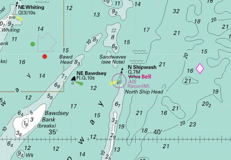
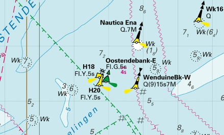
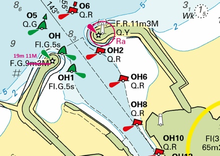
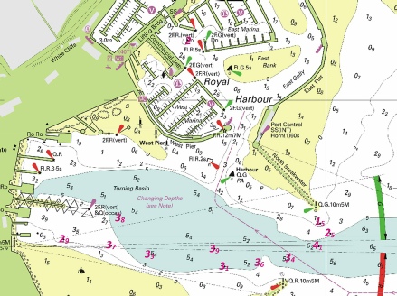
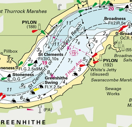
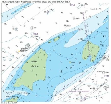
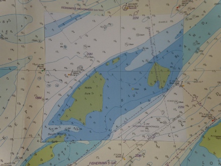
 Fl.Y.5s
 Fl.Y.5s
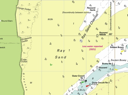
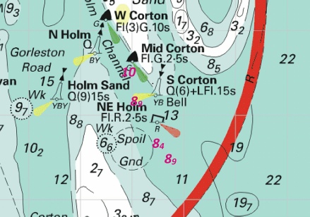


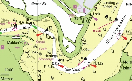
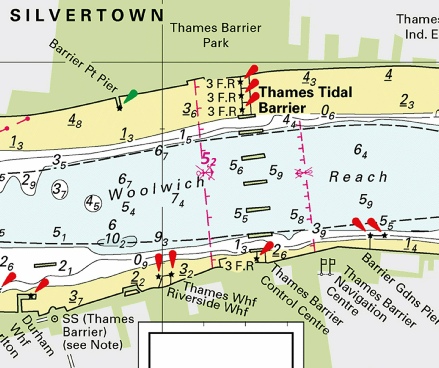
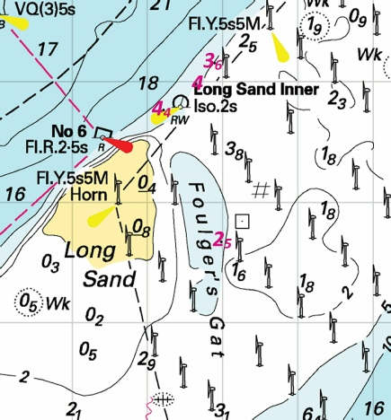
 at 51° 44´·01N., 0° 48´·02E.
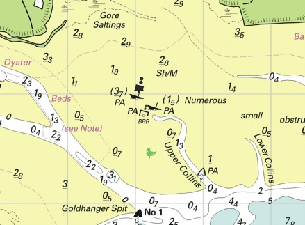
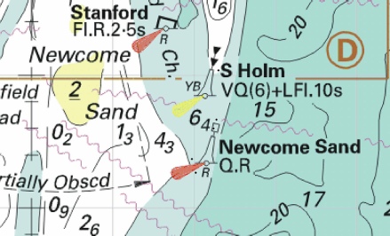
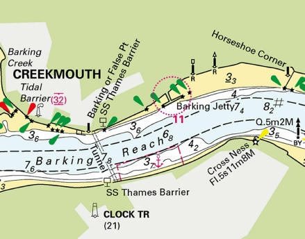
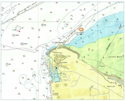
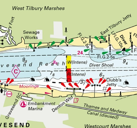
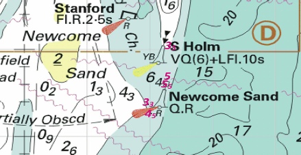
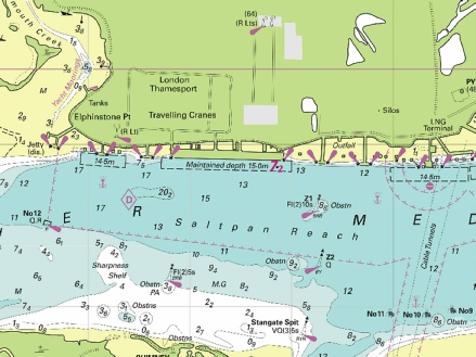


 Obstn
Obstn 
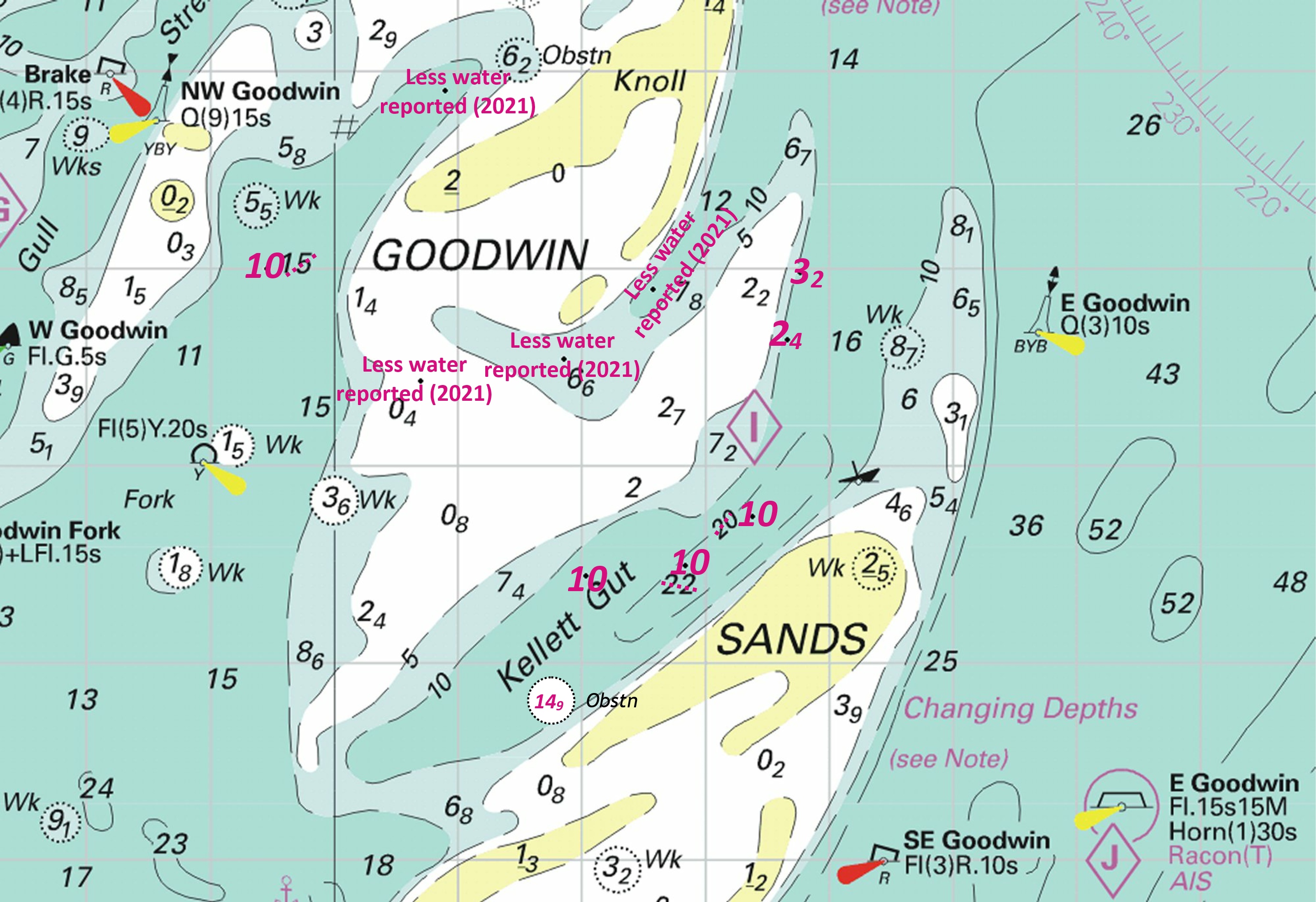

 Fl.Y.5s H8
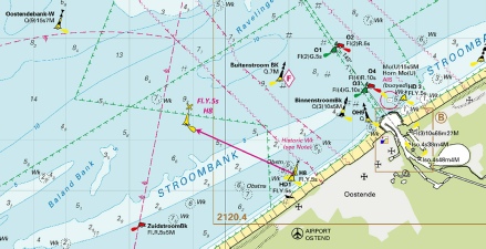
 Fl(5)Y.20s MT3
  Fl(5)Y.20s MT4
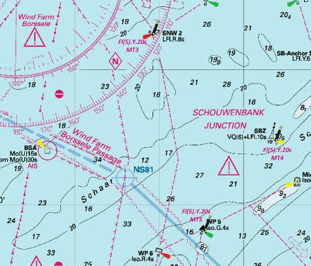
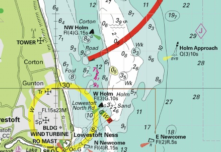
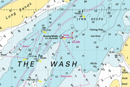
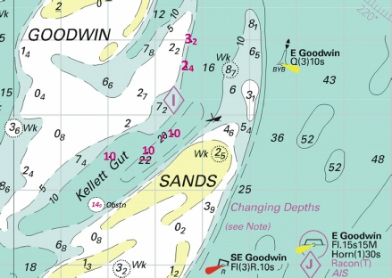
 , joining:
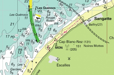
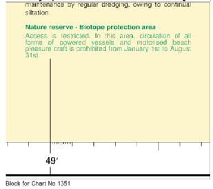
 Fl(5)Y
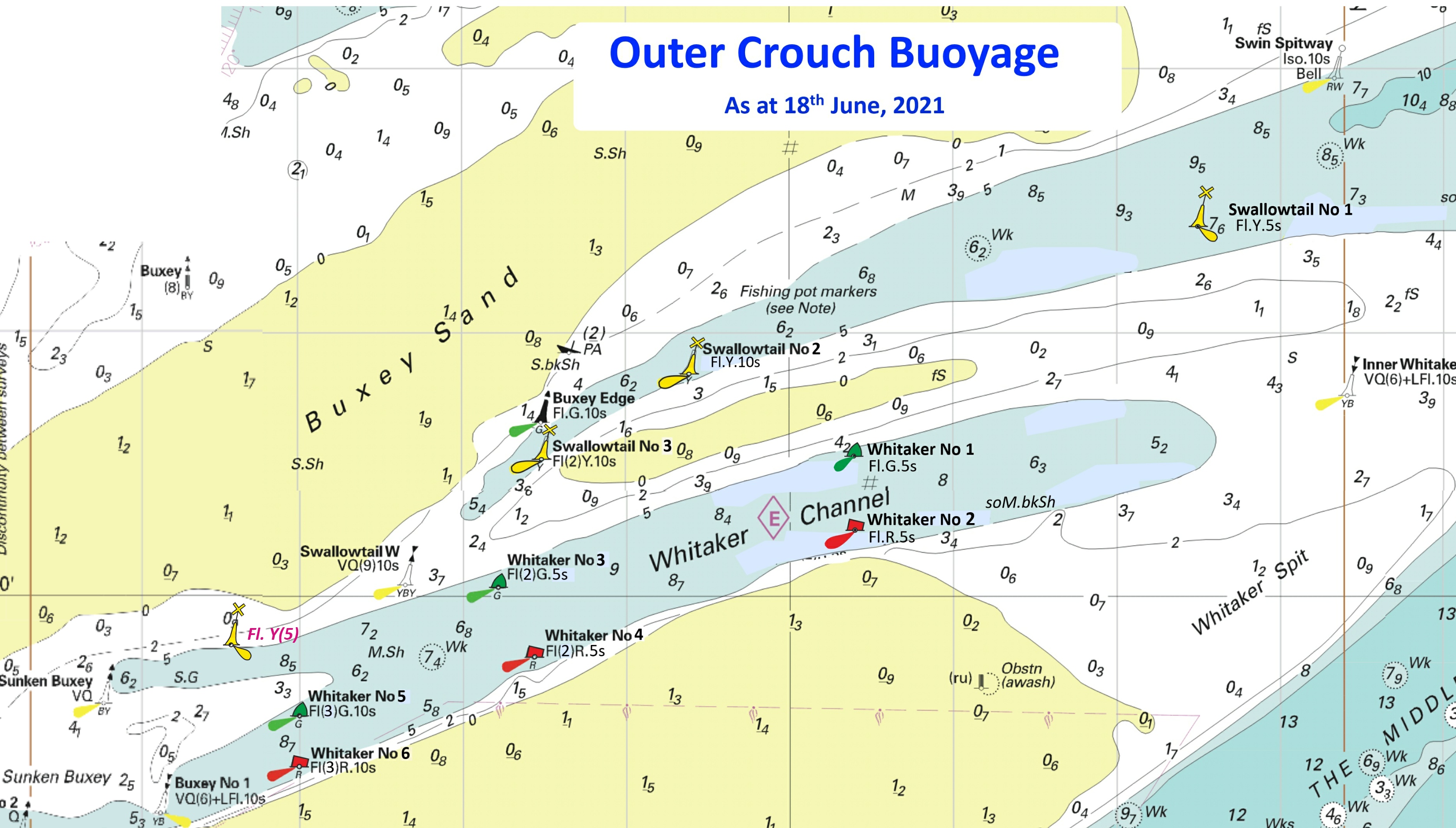
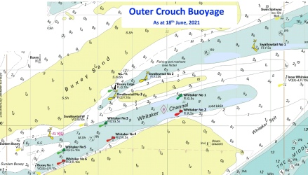
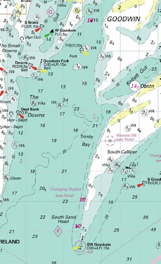

 Q(6)+LFl.15s S Corton Bell
 Fl.R.2·5s NE Holm
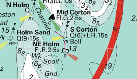
 , centred on:
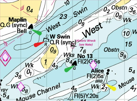
 ,
, 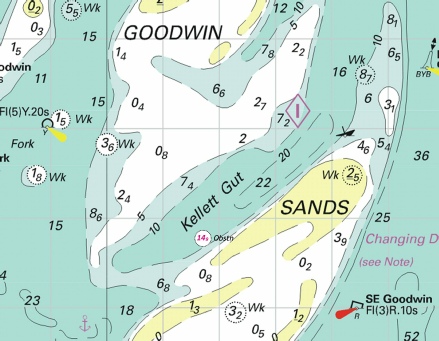
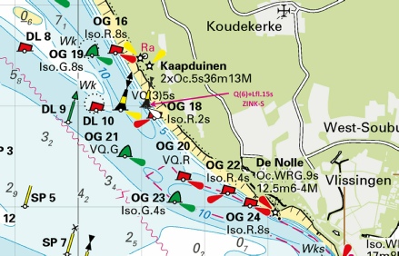
 with
with  2F.G(vert) at 51° 06´·949N., 1° 19´·176E.
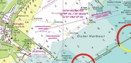
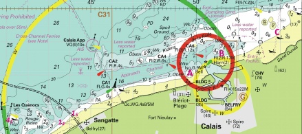
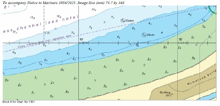
 , centred on:
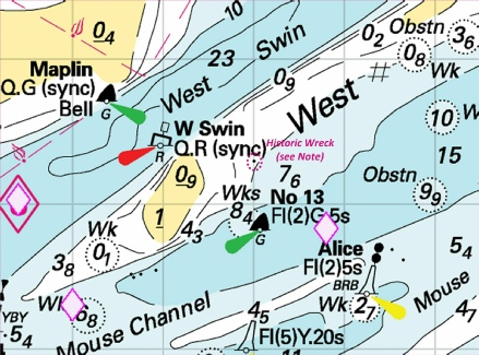
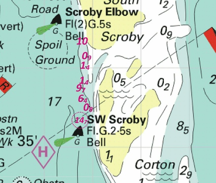
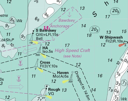
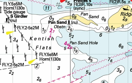
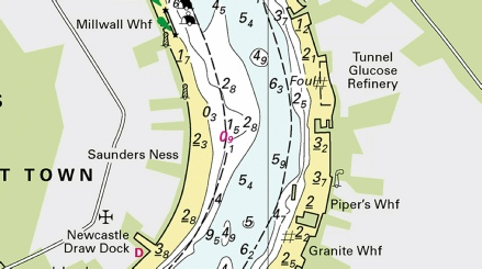
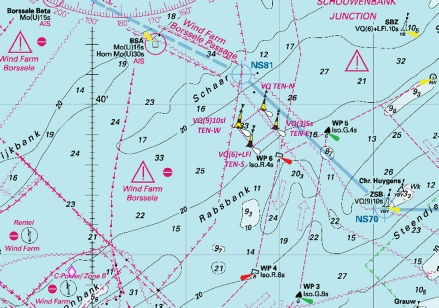
 at 51° 30´·13N., 0° 39´·74E. and 51° 29´·75N., 0° 42´·13E.
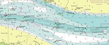

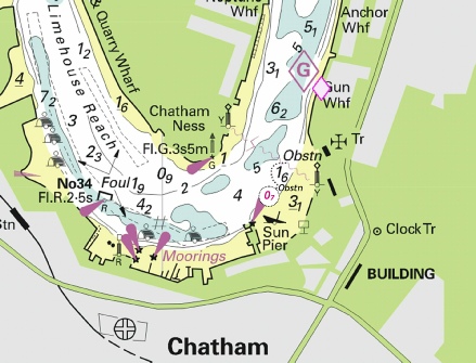
 , centred on: 51° 16´·19N., 1° 29´·97E.
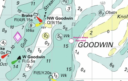
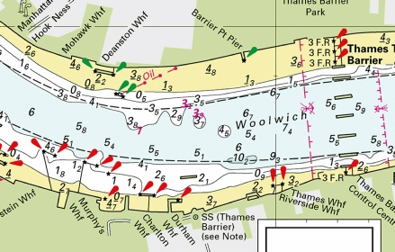
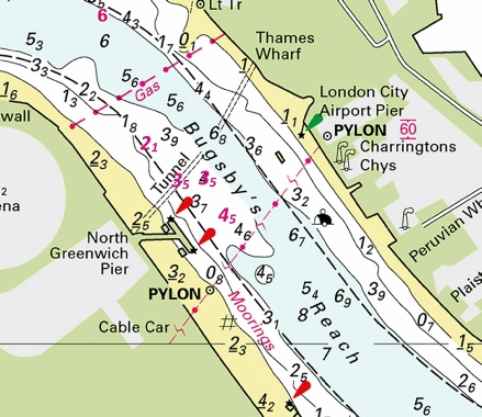
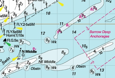
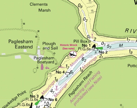
 Fl(5)Y.20s
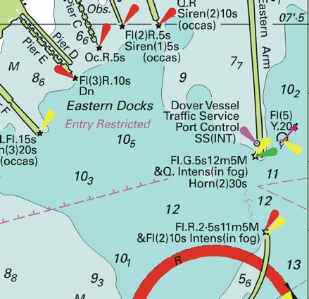
 at 51° 38´·18N., 1° 17´·84E.

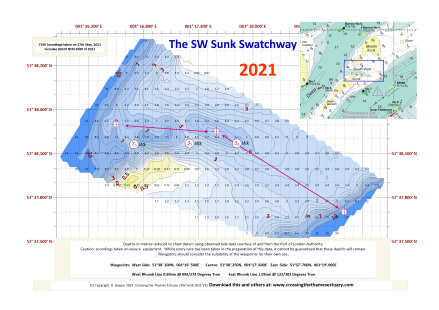

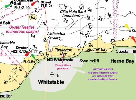
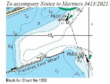
 Q
Q  Iso.G.4s WFB 1
  Iso.R.4s WFB 2

 at 51° 30´·22N., 0° 36´·83E.
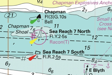
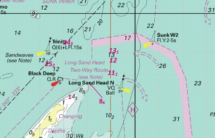
 Fl.R.5·5s at 51° 38´·43N., 0° 45´·80E.
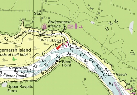
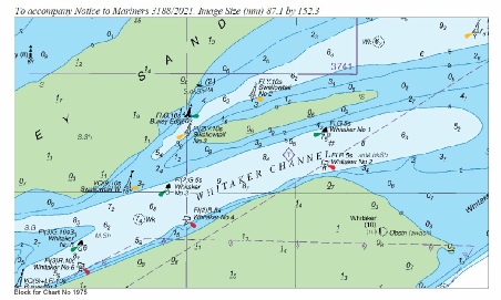
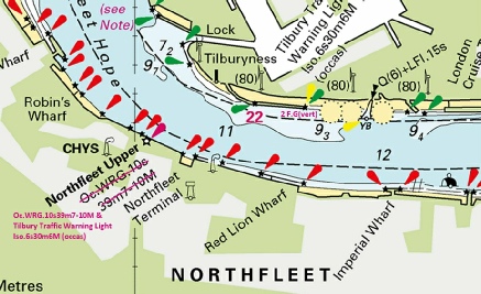
 at 51° 26´·830N., 0° 25´·364E.
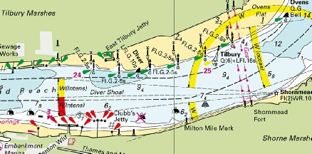

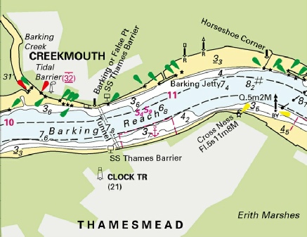
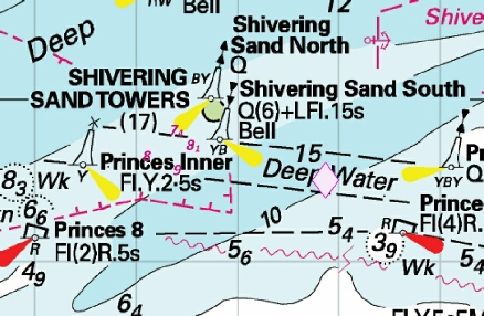
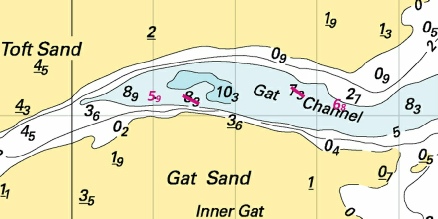
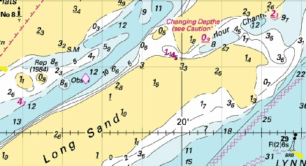
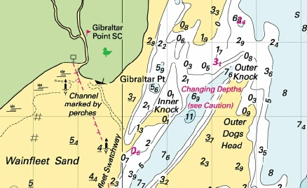
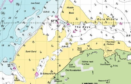
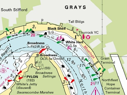
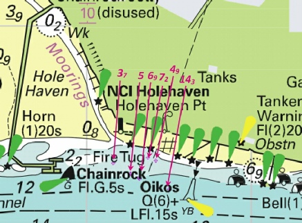

 at 51° 29´·05N., 0° 56´·81E.
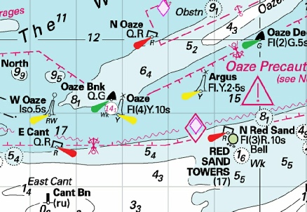
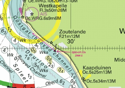
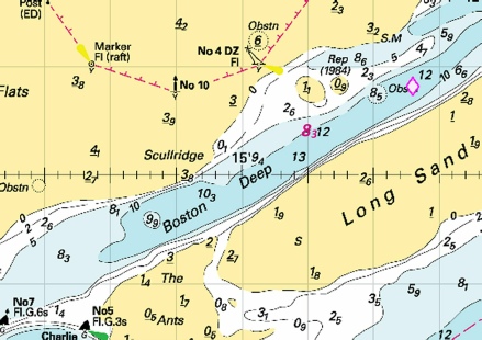
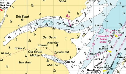
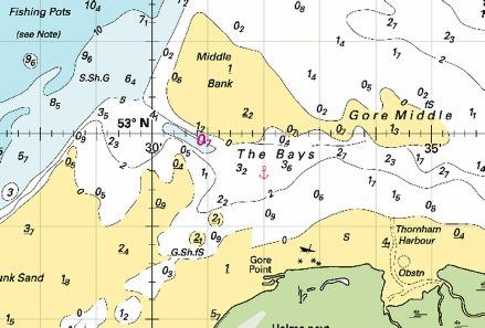

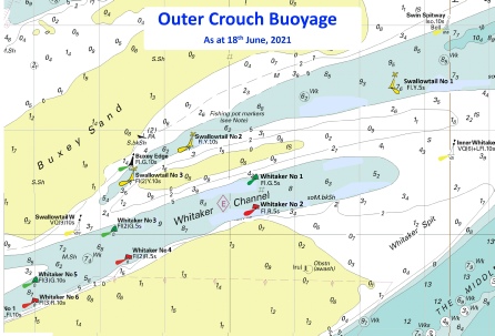
 Q.Y
Q.Y 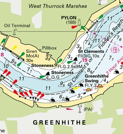
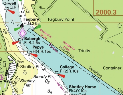
 at
at  , radius 220m, centred on:
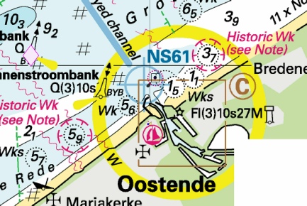
 Q.R Fairway No 2
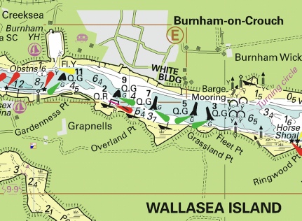
 with
with  at 51° 27´·278N., 0° 16´·833E.
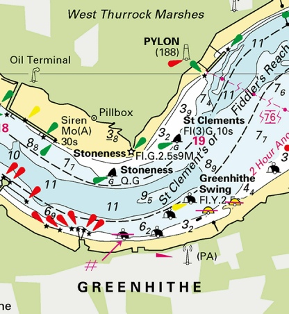
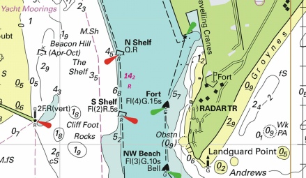
 Pontoon Barge
  Fl.Y.2s
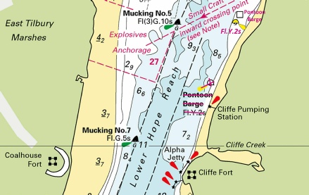
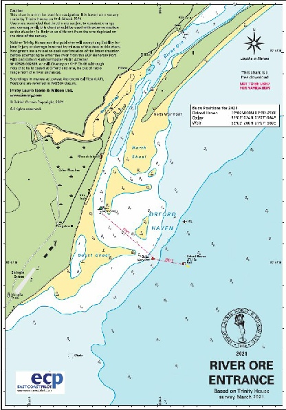

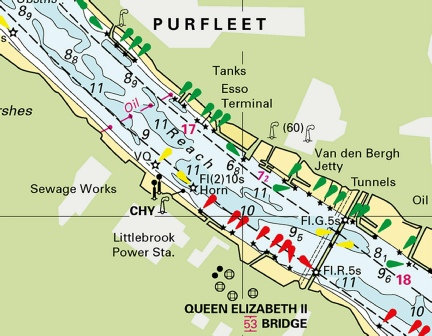

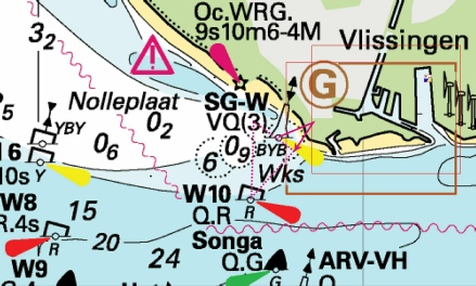
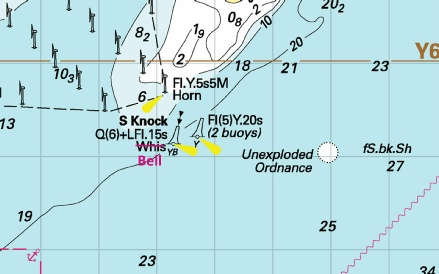
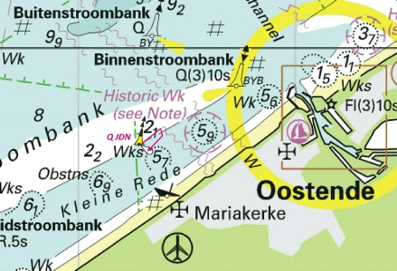
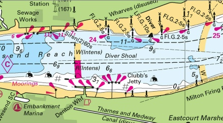
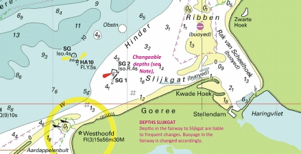
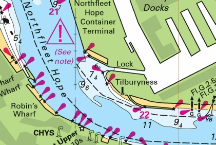
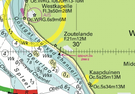
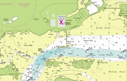
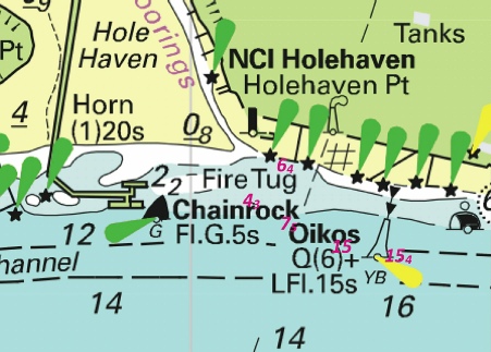
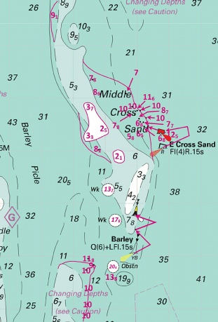
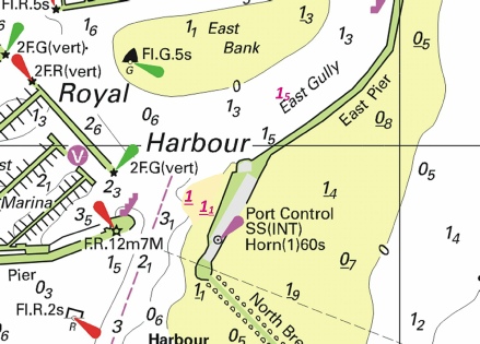
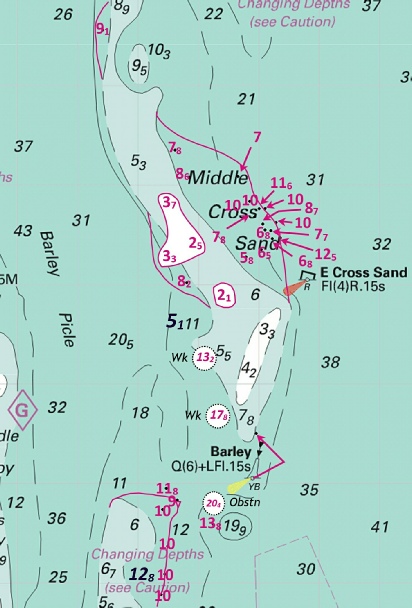
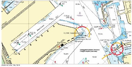
 at 51° 29´·58N., 0° 51´·72E.
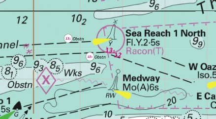
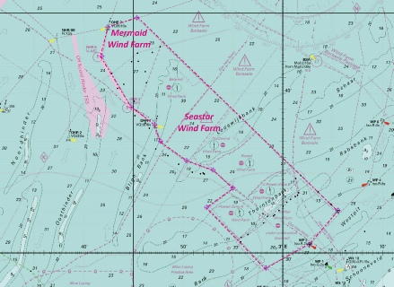
 at:
at: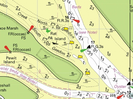
 at:
at: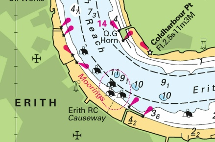
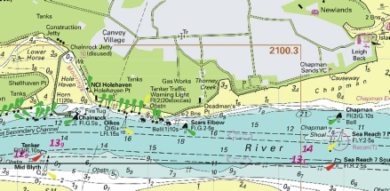
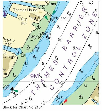
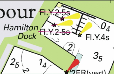
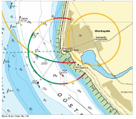
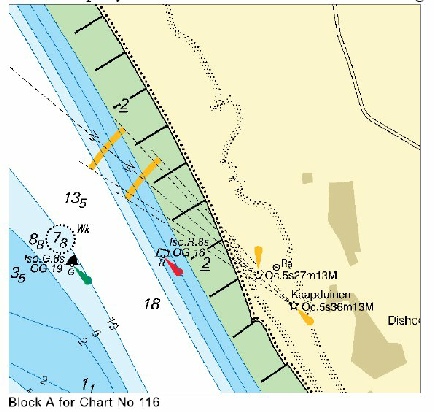
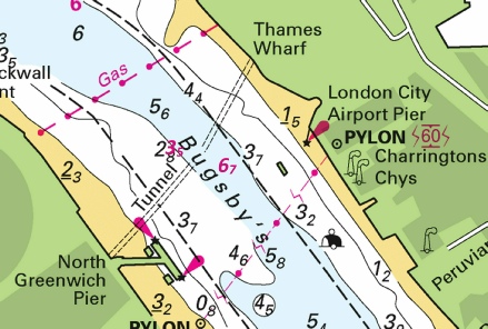
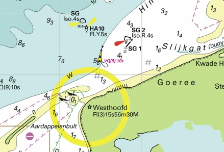

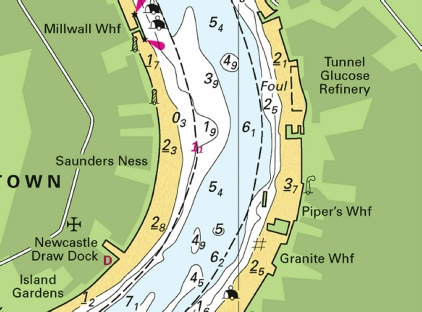
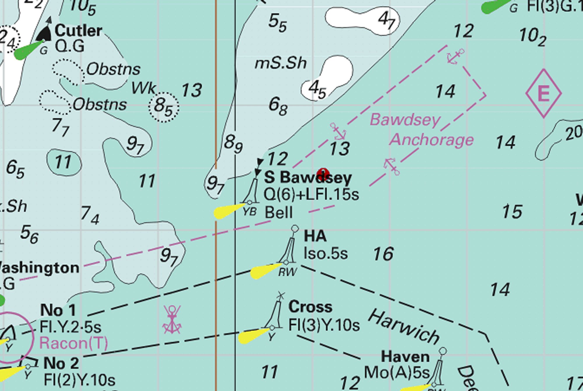
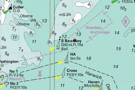
 VQ WF-
 VQ(3)5s WF-
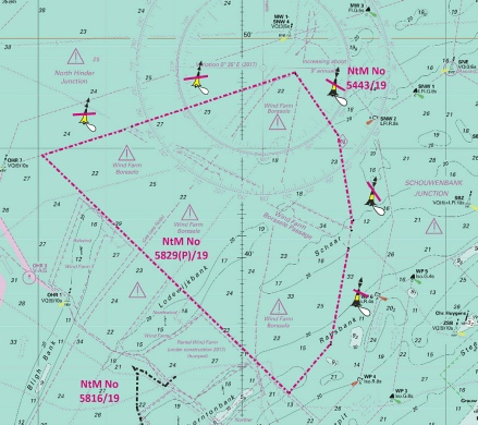
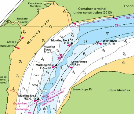
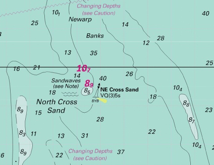
 Fl.R.5s
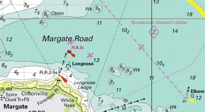
 from: 51° 07´·348N., 1° 20´·641E. to: 51° 07´·328N., 1° 20´·646E.
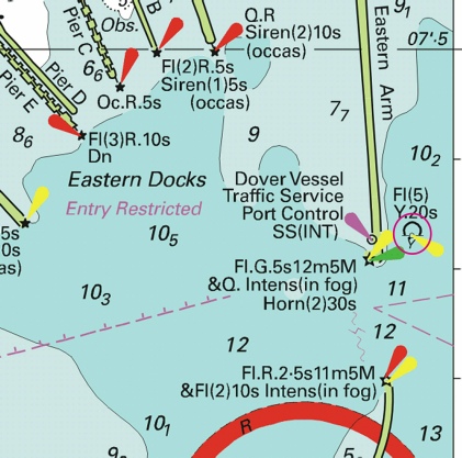
 Fl(5)Y.20s2M (3 buoys)
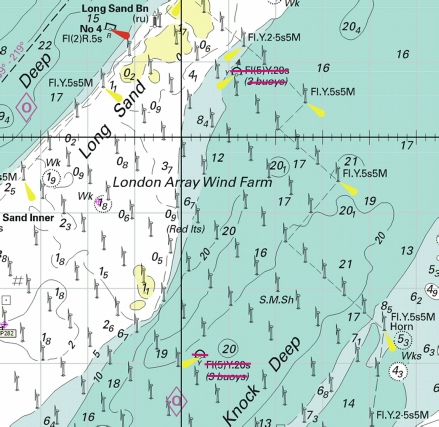
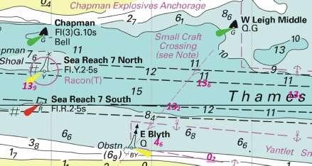
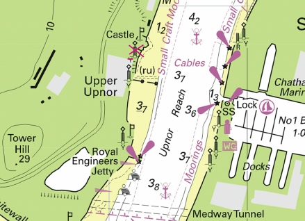
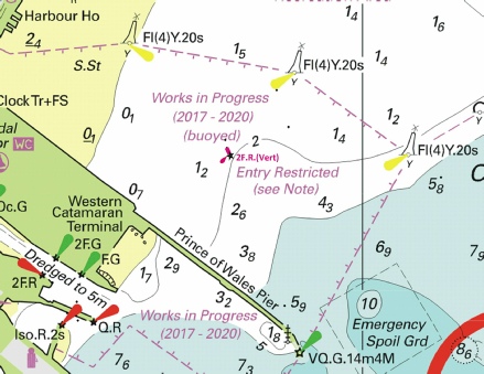
 at 51° 28´·80N., 1° 35´·00E.
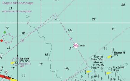
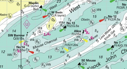
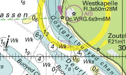
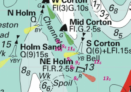
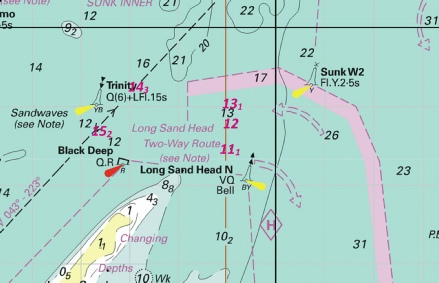
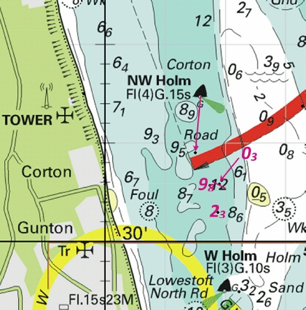
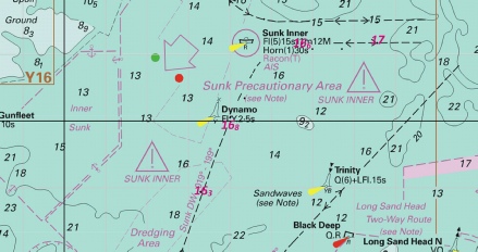
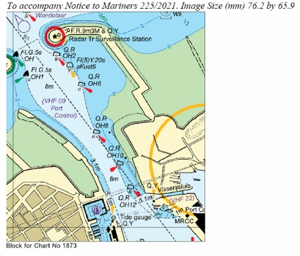
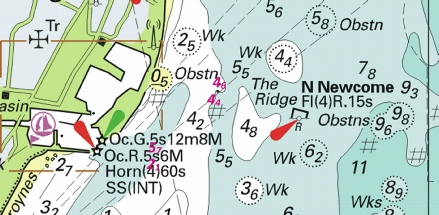
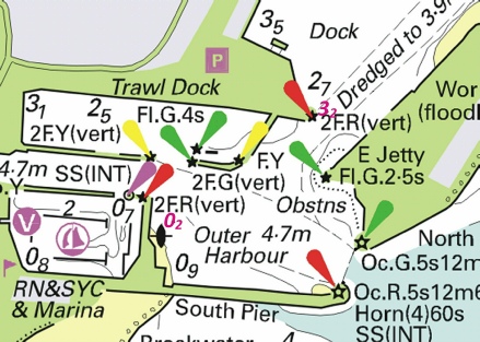
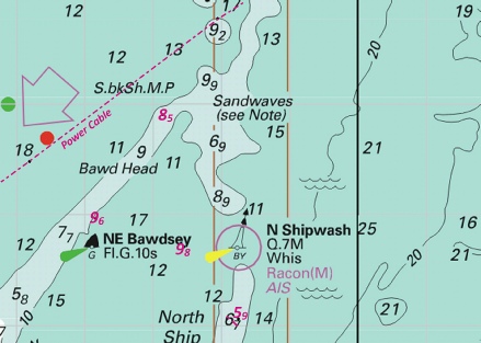
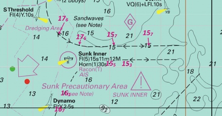
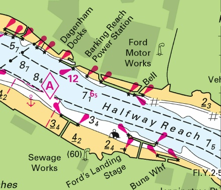
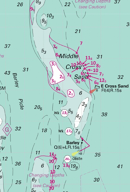
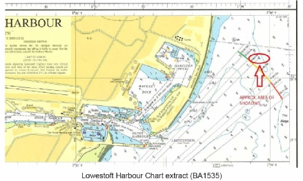
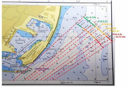
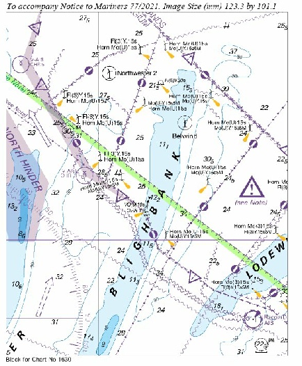
 at 51° 14´·94N., 2° 16´·53E.
 at 51° 10´·88N., 2° 21´·40E.
 Obstn
Obstn  Fl(5)Y.20s