|
Notices - |
||
|
SCROLL DOWN FOR 2024 NOTICES |
||
|
Week 51 |
ENGLAND - The isolated danger light- Mariners are advised to navigate with caution in the area and consult the local port authorities for the latest information. Notice 5751(T) refers base image courtesy of Imray Chart Y9 and Meridian Chartware.
|
Affects: UKHO SNC: 108 and 1190. UKHO SCC: 5614.8 and 5614.9. Imray Full Charts: Y9 The unnamed isolated danger light buoy in the Well in the Wash is off station at present.
|
|
Week 45 |
ENGLAND - Insert:
Delete:
Notice 5131 refers The base image courtesy of Imray Chart Y9 and Meridian Chartware.
|
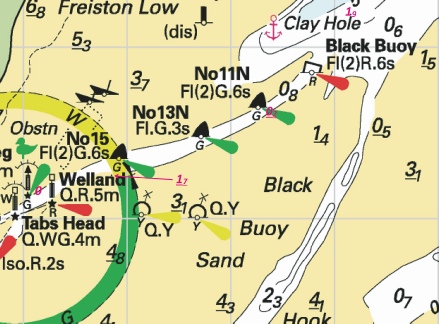
Affects: UKHO SNC: 1200 (Panel A, The Wash Eastern Part). UKHO SCC: 5614.10 (Pane A, The Wash, Eastern Part) Imray Full Charts: Y9 Establishment of a new Yellow special lit buoy in the channel to Kings Lynn. Back in July local notices reported the damage and loss of lit beacon ‘B’ following a collision with a fishing vessel. The yellow special buoy replaces the mark approximately 20 m south of the remains of the old beacon which is now regarded as ‘FOUL’ ground.
|
|
Week 37 |
ENGLAND - Insert: drying height, 0.4, and extend 0m approximate low water line NW to enclose 52° 57´·26N., 0° 28´·30E. Delete depth, 0.1, close SE. drying height, 1.8, enclosed by 0m approximate low water line at 52° 54´·54N., 0° 25´·19E. Delete depth, 0.1, close E. Notice 4141 refers The base image courtesy of Imray ID10 Chart Y9 and Meridian Chartware.
|
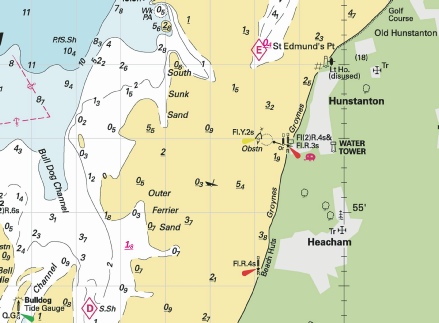
Affects: UKHO SNC: 108 and 1200. UKHO SCC: 5614.10 (Panel A, The Wash Eastern Part) and 5614.9. Imray Full Charts: Y9 Two new drying heights in the Eastern part of the Wash, off St Edmund’s Point, Hunstanton abd at the Outer Ferrier Sand off Heacham.
|
|
Week 32 |
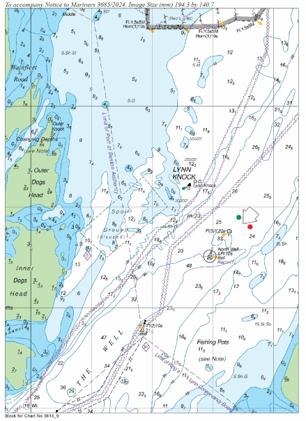
ENGLAND - Chart 108 Insert the accompanying block, centred on: 53° 04´·0N., 0° 26´·0E. Chart 1190 Insert the accompanying block, centred on: 53° 04´·5N., 0° 26´·9E. Chart 1200 Insert the accompanying block, centred on: 52° 54´·9N., 0° 16´·2E. Chart 5614.11 (Panel A, The Wash Central Part) Insert the accompanying block, centred on: 52° 54´·9N., 0° 16´·2E. Chart 5614.9 Insert the accompanying block, centred on: 53° 03´·9N., 0° 26´·0E. Chart 5614.13 Insert the accompanying block, centred on: 53° 06´·3N., 0° 29´·0E. Chart 5614.8 Insert the accompanying block, centred on: 53° 04´·5N., 0° 26´·9E. Notice 3685 refers UKHO Blocks are copyright of the UKHO.
|
Affects: UKHO SNC: 1190 and 1200. UKHO SCC: 5614.11 (Panel A, The Wash Central Part), 5614.9, 5614.13 and 5614.8 Imray Full Charts: Y9. This notice provides 7 new UKHO blocks generally centred around the Lynn Knock area in the Wash. The blocks are variously for 3 SN charts and 4 SC charts.
|
|
Week 24 |
ENGLAND - Insert: depth, 1.9, and extend 2m contour NE to enclose 52° 57´·19N., 0° 08´·16E. Delete depth, 3.2, close W. drying height, 0.2, and extend 0m low water line SE to enclose 52° 56´·63N., 0° 07´·37E. Delete depth, 1.5, close SE. drying height, 1.7 at 52° 56´·25N., 0° 05´·85E. Delete drying height, 1, close NE. depth, 0, and extend 0m low water line S to enclose 52° 56´·16N., 0° 05´·16E. Notice 2759 refers Base image courtesy of Imray ID10 Chart Y9 and Meridian Chartware.
|
Affects: UKHO SNC: 1200 (Panel B, Approaches to Boston) and 1200. UKHO SCC: 5614.12 Imray Full Charts: Y9 4 reductions of depth in the Boston approach channel, one of which is 0 depth and 2 are drying heights.
|
|
Week 21 |
ENGLAND - Insert: the accompanying note, MARINE FARMS, centred on: 53° 18´·72N., 0° 10´·40E. limit of marine farm, pecked line, joining: (a) 53° 01´·46N., 0° 58´·56E. (b) 53° 01´·48N., 0° 58´·04E. (c) 53° 01´·77N., 0° 58´·08E. (d) 53° 01´·76N., 0° 58´·66E.
(a) above (b) above (c) above (d) above Charts 1190 and 1503 Insert: the accompanying note, MARINE FARMS, centred on: 52° 55´·78N., 0° 44´·76E on Chart 1190 and at 52° 58´·32N., 3° 04´·15E on chart 1503.
Notice 2237 refers Base image courtesy of Imray ID10 Chart C28 and Meridian Chartware.
|
Affects: UKHO SNC: 108, 1190 and 1503. UKHO SCC: 5614.7 (Panel A, Cromer to Wells- Imray Full Charts: C28 Marine Farm established 2.3nm approx. due north of the Blakeney Fairway buoy. The Marine Farm with marked by 4 yellow special lit buoys.
|
|
Week 16 |
New Editions of ADMIRALTY Small Craft Charts to be published 18 April 2024 SCC 5614.7 A Cromer to Wells- B Wells- New Editions of ADMIRALTY Small Craft Charts to be published 2 May 2024 SCC 5614.8 Outer Approaches to The Wash. 1:150,000 SCC 5614.9 Approaches to The Wash. 1:75,000 |
Includes full updates for New Edition and Notices to Mariners affecting source charts. Includes full updates for New Edition and Notices to Mariners affecting source charts. |
|
Week 10 |
ENGLAND - Delete:
Notice 1076 refers Base image courtesy of Imray ID10 Chart Y9 and Meridian Chartware.
|
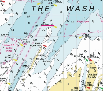
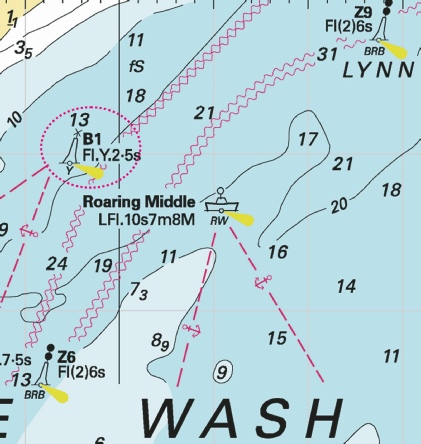
Affects: UKHO SNC: 1200, Note: This update is included in New Edition 108, published 22 February 2024. UKHO SCC: 5614.10 (Panel A, The Wash Eastern Part), 5614.11 (Panel A, The Wash Central Part and 5614.9. Imray Full Charts: Y9 The Yellow special lit buoy at the northerly tip of the Roaring Middle shoal in the centre of the Wash is deleted.
|
|
Week 09 |
ENGLAND - The unlit buoy, DZ No 2, in position 52° 54´·42N., 0° 07´·48E., is reported missing. Mariners are advised to navigate with caution in the area. Notice 893(T) refers Base image courtesy of Imray ID10 Chart Y9 and Meridian Chartware.
|
Affects: UKHO SNC: 1200. UKHO SCC: 5614.11 (Panel A, The Wash Central Part) [ and 5614.12 (Panel A, The Wash Western Part) Imray Full Charts: Y9 Following on Notice 872 last week which reported the change of top mark (yellow ‘X’) and light characteristics for the DZ3 buoy which marks part of the western side of the Holbeach Firing Practice Area in the Wash, this temporary notice is reporting that the adjacent special yellow buoy DZ2 is missing.
|
|
Week 08 |
ENGLAND - Delete: Automatic Identification System, AIS, at B1 light- Notice 794 refers Base image courtesy of Imray ID10 Chart IN5043 and Meridian Chartware.
|
Affects: UKHO SNC: 1200 UKHO SCC: 5614.11 and 5614.12 Imray Full Charts: Y9 AIS has been removed from the B1 lit buoy in the Wash. The B1 buoy is a yellow special buoy marking the apex of the shipping anchorage at the approaches to Boston.
|
|
Week 08 |
ENGLAND - Insert: depth, 4.9 , enclosed by 5m contour at 51° 57´·110N., 1° 15´·077E. Replace: depth, 5.3 , with depth, 4 , enclosed by 5m contour at 51° 56´·948N., 1° 17´·011E. Notice 815 refers Base image courtesy of Imray ID10 Chart Y16 and Meridian Chartware.
|
Affects: UKHO SNC: 1491 and 2693 UKHO SCC: 5607.7 Imray Full Charts: Y16 Imray Leisure Folios: 2000.5 Two reductions of depth in the River Stour, one west of the Parkeston starboard hand buoy, the other off the Trinity House Pier. At 4m+ unlikely to hinder leisure craft.
|
|
Week 06 |
New Editions of ADMIRALTY Charts to be published on 22nd February, 2024 Chart 106 England - 1:75,000 Chart 108 England - Wells- |
Includes significant safety- Amendments to depths from the latest British Government surveys. |
|
Week 06 |
ENGLAND - Replace:
Notice 634 refers Base image courtesy of Imray ID10 Chart Y9 and Meridian Chartware.
|
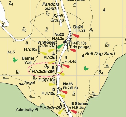
Affects: UKHO SNC: 1200 UKHO SCC: 5614.10 (Panel A, the Wash Eastern Part) Imray Full Charts: Y9 This notice reports a change of mark in the approaches to Kings Lynn. Beacon ‘B’ was destroyed last year and replaced with a lit yellow special buoy. Now the Beacon ‘B’ has been reinstated as before in lieu of the temporary yellow special buoy.
|
|
SCROLL DOWN FOR 2024 NOTICES |
||


%2024.jpg)
 Fl.Y.2s B
  Fl.Y.2s B, close NE above
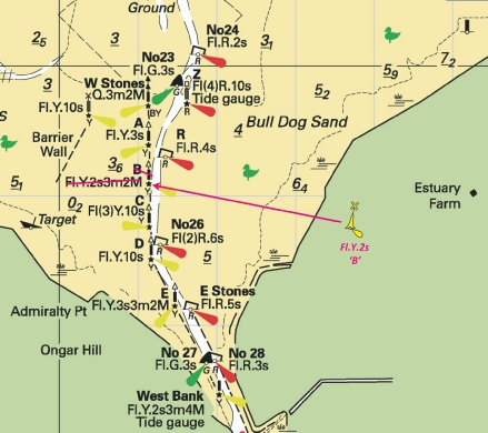
 , within:
  Fl.Y.5s
 at 53° 01´·61N., 0° 58´·27E.
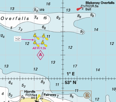

.jpg)

 Fl.Y.2s B
  Fl.Y.2s B at 52° 49´·09N., 0° 21´·14E.