|
2017 Permanent Notices to Mariners - |
||
|
Week 52 |
New Editions of ADMIRALTY Charts on 11th January, 2018 Chart 1351 - |
Includes changes to depths and dredged areas. (A modified reproduction of INT1483 published by France.) |
|
Week 52 |
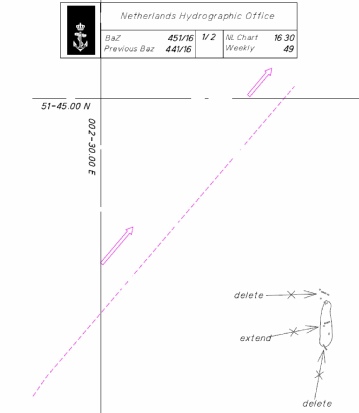
ENGLAND - Insert: depth, 5, and extend 5m contour W to enclose 52° 27´·46N., 1° 47´·07E. Delete depth, 5.9, close E. depth, 5, and extend 5m contour S to enclose 52° 26´·87N., 1° 47´·27E. depth, 6.3 at 52° 26´·85N., 1° 47´·01E. depth, 4.5, and extend 5m contour E to enclose 52° 26´·43N., 1° 47´·01E. depth, 4.6, and extend 5m contour NE to enclose 52° 26´·33N., 1° 47´·09E. Delete depth, 4.6, close SW and depth, 6.4, close E. depth, 3.8 at 52° 26´·32N., 1° 46´·96E. Replace:
Move:
Image courtesy of Imray Charts C28 and Meridian ID10 |
Affects: UKHO Charts: 1535 Imray Charts: C28 UKHO Leisure Folios: 5614.2 and 5614.3 A collection of 7 reduced depths in the Stanford Channel with a group around the Newcome Sand PHM buoy (which is also slightly moved. But not critical to leisure craft.
|
|
Week 51 |
ENGLAND - Insert:
at 52° 55´·81N., 0° 16´·39E.
Image courtesy of Imray Charts Y9 and Meridian ID10 |
Affects: UKHO Charts: 108 and 1200 Imray Charts: Y9 UKHO Leisure Folios: 5614.9. New radio reporting position in the Wash.
|
|
Week 51 |
ENGLAND - Delete:
symbol, blue and yellow emergency wreck marking buoy, Al.Oc.BuY.3s, and associated radar beacon, Racon(D) at 52° 25´·50N., 1° 49´·67E. symbol, blue and yellow emergency wreck marking buoy, Al.Oc.BuY.3s at: 52° 25´·23N., 1° 49´·22E., 52° 25´·23N., 1° 50´·11E. and 52° 24´·96N., 1° 49´·67E.
Image courtesy of Imray Charts C28 and Meridian ID10 |
Affects: UKHO Charts: 1408, 1504, 1535 and 1543 Imray Charts: C28 UKHO Leisure Folios: 5614.1 5614.2 The wreck ‘Ella’ has been removed and the wreck buoys marking the hazard has been deleted. The original notification was in Week 38 vide NtM 4392.
|
|
Week 50 |
ENGLAND - Insert: drying height, 0.2, enclosed by 0m low water line at 51°27´·580N., 0°44´·704E. Delete depth, 0.2, close SW.
Image courtesy of Imray Charts Y18 and Meridian ID10 |
Affects: UKHO Charts: 1185 and 3683 Imray Charts: Y18.1 UKHO Leisure Folios: 5606.9. Imray Leisure Folio: 2100.2, 2100.4 New drying height off the Grain Spit opposite Sheerness.
|
|
Week 49 |
ENGLAND - Insert: the accompanying block, centred on: 51° 56´·9N., 1° 12´·8E. depth, 1.8, enclosed by 2m contour at 51° 57´·051N., 1° 10´·737E. Delete depth, 2.3, close NW depth, 0.5 at 51° 57´·255N., 1° 10´·752E. depth, 0.7 at 51° 57´·184N., 1° 11´·342E. depth, 4.8, at enclosed by 5m contour 51° 57´·084N., 1° 11´·926E.
Image courtesy of Imray Charts Y16 and Meridian ID10 |
Affects: UKHO Charts: 1594 Imray Charts: Y16 UKHO Leisure Folios: 5607.7. Imray Leisure Folio: 2000.4, 2000.5, A new UKHO block for the Stour just west of Erwarton and 4 reduced soundings between the block and Holbrook. The second image is the UKHO block (UKHO copyright).
|
|
Week 49 |
FRANCE - Numerous changes to depths and dredged areas exist within the Port of Calais. The most significant are as follows: a) A 12·5m dredged area, centred on position 50° 58´·228N., 1° 51´·826E., is now dredged to 11·5m. b) An 8·0m dredged area exists, centred on position 50° 58´·182N., 1° 51´·346E. c) An 8·0m dredged area exists at Berth 9, centred on position 50° 58´·082N., 1° 51´·589E. d) An extended 6·5m dredged area exists at Berth 6, centred on position 50° 58´·080N., 1° 50´·890E. e) Dredging to a depth of 7·2m has been carried out in the Arrière- f) A 9·5m dredged area, centred on position 50° 57´·838N., 1° 51´·170E., at Quai Paul Devot, is now dredged to 8·5m. g) The Bassin Carnot, centred on position 50° 57´·658N., 1° 51´·609E., has a depth of 5·8m. These changes will be included in a New Edition of Chart 1351 to be published in January 2018 and in a New Edition of Chart 8164 to be published mid 2018.
Image courtesy of Imray Charts C8G and C1, and Meridian ID10 |
Affects: UKHO Charts: 1351 and 8164 Imray Charts: C8G UKHO Leisure Folios: 5605.12. Imray Leisure Folio: 2100.10 Revised depths with the commercial side of Calais Harbour. All unlikely to hinder leisure craft.
|
|
Week 49 |
ENGLAND - Insert: drying height, 0.3, enclosed by 0m low water line at 51° 45´·98N., 0° 58´·38E. drying height, 1.1, enclosed by 0m low water line at 51° 46´·10N., 0° 59´·11E. drying height, 1.4, enclosed by 0m low water line at 51° 46´·47N., 1° 00´·73E. depth, 1.9, and extend 2m contour SW to enclose 51° 46´·75N., 1° 01´·40E. Delete depth, 2.6, close NW depth, 1.8, enclosed by 2m contour 51° 46´·18N., 1° 08´·36E. Delete depth, 25 , close E depth, 1.8 at 51° 50´·74N., 1° 17´·16E.
Image courtesy of Imray Charts Y17 and C1, and Meridian ID10 |
Affects: UKHO Charts: 1183, 1975, 2052 and 3741 Imray Charts: Y16 and C1 UKHO Leisure Folios: 5607.2, 5607.3. Imray Leisure Folio: 2000.7 There are six reduced depths/new drying areas – 3 drying areas off the Mersea Flats, a reduction of depth on the east side of the River Colne, one off Jaywick and one off Walton-
|
|
Week 49 |
ENGLAND - Insert: depth, 9.8, and extend 10m contour N to enclose 52° 32´·40N., 1° 48´·60E. Delete depth, 10.6, close SE
Image courtesy of Imray Charts C28 and Meridian ID10 |
Affects: UKHO Charts: 1534, 1535 and 1543 Imray Charts: C25 UKHO Leisure Folios: 5614.2 One slight reduced of depth just south of the NE Holm PHB. Not likely to hinder leisure craft (an earlier NtM just north of the NE Holm buoy is also shown – this was NtM 4332/2017 week 37).
|
|
Week 48 |
ENGLAND - Insert:
Image courtesy of Imray Chart C2 and Meridian ID10 |
Affects: UKHO Charts: 2151, 2484 and 3337 Imray Charts: C2 UKHO Leisure Folios: 5606.14. Imray Leisure Folio: 2100.3 A new dangerous wreck with commensurate west cardinal buoy in Gallions Reach.
|
|
Week 48 |
ENGLAND - Insert: drying height, 0 3 enclosed by 0m low water line at 52° 43´·61N., 1° 42´·11E. Delete depth, 1.5, close NE depth, 8.8, enclosed by 10m contour at 52° 41´·18N., 1° 43´·77E. Delete depth, 10.8, close S depth, 2.4, and extend 5m contour W to enclose 52° 39´·43N., 1° 44´·80E. Delete depth, 7.2, close S depth, 4.3, and extend 5m contour W to enclose 52° 38´·90N., 1° 44´·98E. Delete depth, 7.8, close S depth, 7.2, and extend 10m contour W to enclose 52° 38´·87N., 1° 44´·86E. Delete depth, 14, close W depth, 5.7 at 52° 36´·85N., 1° 44´·93E. depth, 9.3, enclosed by 10m contour 52° 32´·88N., 1° 45´·86E. depth, 9.6, and extend 10m contour E to enclose 52° 32´·68N., 1° 45´·80E. depth, 9.9, enclosed by 10m contour at 52° 32´·68N., 1° 46´·00E. Delete depth, 10.9, close N or W or depth, 10.2, close S dependent on chart. Replace: depth, 4.9, with depth, 4.1 at 52° 46´·97N., 1° 37´·83E. depth, 13.2, with depth, 9.8, and extend 10m contour W to enclose 52° 40´·13N., 1° 44´·39E.
Image courtesy of Imray Chart C28 and Meridian ID10 |
Affects: UKHO Charts: 106, 1534, 1535 and 1543 Imray Charts: C28 UKHO Leisure Folios: 5614.2 Twelve new reductions of depth between Winterton-
|
|
Week 48 |
ENGLAND - Insert: Insert depth, 8.9, and extend 10m contour SE to enclose 51° 27´·43N., 0° 26´·38E. Delete depth, 9.5, close NE
Image courtesy of Imray Chart C2 and Meridian ID10 |
Affects: UKHO Charts: 1186 and 2484 Imray Charts: C2 UKHO Leisure Folios: 5606.13. Imray Leisure Folio: 2100.3 A new reduction of depth on the edge of the Thames channel (but at 8.9m will not hinder leisure craft).
|
|
Week 47 |
Admiralty Charts to be published 23 November 2017 Chart 323 - Note: This chart remains affected by Notices 956(T)/16, 490(T)/17 and 5072(T)/17. Chart 1610 - Note: This chart is to be deleted from the list of charts affected by Notice 3496(P)/17. This chart remains affected by Notices 490(T)/17, 4087(P)/17 and 5072(T)/17. Admiralty Charts to be published 7 December 2017 Chart 1491 - Chart 2693 - A Continuation of River Stour. 1:25,000 B Ipswich. 1:10,000 C Continuation of River Deben. 1:25,000 |
Includes changes to depths from the latest British Government Surveys. Includes changes to depths, wrecks, obstructions, windfarms and territorial sea limits. Includes significant safety- Includes significant safety- |
|
Week 47 |
ENGLAND - Insert:
Image courtesy of Imray Chart C2 and Meridian ID10 |
Affects: UKHO Charts: 1185, 1186 and 2484 Imray Charts: C2 UKHO Leisure Folios: 5606.8. Imray Leisure Folio: 2100.2, 2100.3 Port of London Authority notified this new south cardinal buoy as a temporary mark part of works off the Oikas Jetty No 2 but it appears likely to be long term. Just east of the Hole Haven creek, the works will have to be avoided.
|
|
Week 47 |
BELGIUM - Insert: limit of foul ground area, pecked line, joining: 51° 17´·77N., 2° 56´·55E. 51° 18´·42N., 2° 58´·20E. 51° 17´·58N., 2° 59´·05E. 51° 16´·93N., 2° 57´·40E. Delete:
Image courtesy of Imray Chart C2 and Meridian ID10 |
Affects: UKHO Charts: 1872, 1873, 1874 and 2449 Imray Charts: C30 UKHO Leisure Folios: 5605.11. A new defined area of FOUL east of Oostende and deletion of two adjacent Fouls close by.
|
|
Week 47 |
ENGLAND - Replace: depth, 4.5, with depth, 4.2 at 51° 29´·743N., 0° 01´·437E.
Image courtesy of Imray Chart C2 and Meridian ID10 |
Affects: UKHO Charts: 2484 and 3337 Imray Charts: C2 UKHO Leisure Folios: 5607.5. Imray Leisure Folio: 2100.3 A slight reduction of depth on the south edge of the Thames channel off Greenwich.
|
|
Week 47 |
ENGLAND - Delete:
Image courtesy of UK Hydrographic Office |
Affects: UKHO Charts: 1185, 1186 and 2484 Imray Charts: Y18 UKHO Leisure Folios: 5606.14B. Imray Leisure Folio: 2100.2 This is confirmation of the Medway (Peel Ports) NtM in Week 45 in the Temporary Notices. The Obstruction at 1.6m is deleted.
|
|
Week 46 |
ENGLAND - Note: This update is included in New Edition 2692, published 16 November 2017 and New Edition 1610, published 23 November 2017. Amend: fog signal to, Bell, at light-
Image courtesy of Imray Chart C1 and Meridian ID10 |
Affects: UKHO Charts: 2052 and 2693 Imray Charts: C1 UKHO Leisure Folios: 5607.5. Imray Leisure Folio: 2000.1 Change of fog signal at the South Bawdsey SCB. This had been reported by Trinity House a couple of weeks earlier.
|
|
Week 46 |
NETHERLANDS - Insert: the accompanying block, centred on: 51° 44´·2N., 3° 37´·2E. depth, 2.9 at 51° 35´·25N., 3° 30´·61E. Delete depth, 3.8, close NE and depth, 4, close W. Replace: depth, 10.4 , with depth, 9.8, enclosed by 10m contour at 51° 50´·36N., 3° 46´·05E.
Image courtesy of Imray Chart C30 and Meridian ID10 |
Affects: UKHO Charts: 110 and 116 Imray Charts: C30 There are three distinct areas of change. 1. A new UKHO block covering the west coast of the Schouwen:
2. A reduction of depth off the Oostkapelle:
3. A reduction of depth off Goeree:
|
|
Week 46 |
FRANCE - Note: This update is included in New Editions 323 and 1610, published 23 November 2017. Insert:
Image courtesy of Imray Chart C30 and Meridian ID10 |
Affects: UKHO Charts: 1872, 1973 and 2449 Imray Charts: C30 UKHO Leisure Folios: 5605.2, 5605.10. Addition of AIS on the H.F.Gravelines west cardinal buoy offshore. The black dot on the image indicates the very slight movement of the position of the buoy.
|
|
Week 46 |
ENGLAND - Insert:
Image courtesy of Imray Chart C30 and Meridian ID10 |
Affects: UKHO Charts: 3337 Imray Charts: C2 UKHO Leisure Folios: 5605.15 Two new large mooring buoys just from the South Dock Marina entrance and a new east cardinal buoy off Convoy’s Wharf, all in Limehouse Reach.
|
|
Week 46 |
ENGLAND - Insert: depth, 4.9, enclosed by 5m contour 51° 19´·559N., 1° 25´·226E. Replace: depth, 5.1, with depth, 4.5, enclosed by 5m contour 51° 19´·561N., 1° 25´·263E.
Image courtesy of Imray Chart C8F and Meridian ID10 |
Affects: UKHO Charts: 1827 and 1828 Imray Charts: C8F UKHO Leisure Folios: 5605.15. Two new reduced depths in the outer harbour of Ramsgate adjacent to the entrance of the Royal Harbour. Not yet likely to trouble leisure craft.
|
|
Week 45 |
New Editions of ADMIRALTY Charts on 23rd November, 2017 Chart 323 - |
Includes changes to depths from the latest British Government Surveys |
|
Week 45 |
BELGIUM - Insert: limit of restricted area, entry prohibited, pecked line, joining: 51° 07´·17N., 2° 34´·60E. 51° 06´·93N., 2° 34´·81E. 51° 06´·88N., 2° 34´·66E. 51° 07´·11N., 2° 34´·45E.
Image courtesy of Imray Chart C30 and Meridian ID10 |
Affects: UKHO Charts: 1873 Imray Charts: C30 Small restriction and marked prohibited area off the De Panne Beaches (the Dunkirk beaches).
|
|
Week 45 |
ENGLAND - Note: This update is included in New Edition 1534, published 9 November 2017 Insert: depth, 8.5, and extend 10m contour NE to enclose 52° 40´·15N., 1° 53´·40E.
Image courtesy of Imray Chart C28 and Meridian ID10 |
Affects: UKHO Charts: 1504, 1534 and 1543 Imray Charts: C28 UKHO Leisure Folios: 5614.2. A single new reduction of depth to the eastern side of the Middle Cross Sand (off Caister).
|
|
Week 44 |
BELGIUM - Delete: legend, Radar Tr Surveillance Station, centred on: 51° 14´·250N., 2° 55´·660E.
Image courtesy of Imray Chart 30 and Meridian ID10 |
Affects: UKHO Charts: 1872, 1873 and 1874 Imray Charts: C30 UKHO Leisure Folios: 5605.12. Deletion of the legend regarding the Radar Surveillance Station at the entrance of the inner jetties of Oostende.
|
|
Week 44 |
ENGLAND - Note: This update is included in New Edition 2151, published 19 October 2017 Insert: depth, 7.3 at 51° 28´·17N., 0° 14´·94E.
Image courtesy of Imray Chart C2 and Meridian ID10 |
Affects: UKHO Charts: 2151 and 2484 Imray Charts: C2 UKHO Leisure Folios: 5606.14. Imray Leisure Folio: 2100.3 A change in depth in the Long Reach off Purfleet. Not for significance for a leisure craft user.
|
|
Week 44 |
NETHERLANDS - Move:
Image courtesy of Imray Chart 30 and Meridian ID10 |
Affects: UKHO Charts: 110 and 1630 Imray Charts: C30 The Pilot boarding place has been moved to the Schouwenbank safe water buoy.
|
|
Week 44 |
BELGIUM - A submarine power cable is being laid between Zeebrugge and Rentel wind farm, joining the following positions: 51° 19´·69N., 3° 10´·14E. 51° 21´·14N., 3° 06´·76E. 51° 23´·91N., 3° 04´·40E. 51° 27´·65N., 3° 04´·61E. 51° 29´·12N., 2° 58´·15E. 51° 32´·85N., 2° 52´·74E. 51° 34´·54N., 2° 55´·13E. Anchoring and fishing is prohibited within the vicinity of these positions. Charts will be updated when works are complete.
Image courtesy of Imray Chart 30 and Meridian ID10 |
Affects: UKHO Charts: 1406, 1630, 1872, 1874, 2449 and 8012 Imray Charts: C30 New submarine power cable out from Zeebrugge to the Thorntonbank Wind Farm.
|
|
Week 44 |
BELGIUM - Now please note of the NtM in Week 4 of 2018. The 4 lateral buoys now deleted but shoaling still occurring. Shoal depths have been reported between the pier heads at Blankenberge, in the vicinity of position 51° 18´·90N., 3° 06´·50E. Light- Buoy Type Designation Characteristic Position Starboard- Starboard- Starboard- Port- Mariners are advised to navigate with caution in the area. Former Notice 4796(T)/15 is cancelled.
Image courtesy of Imray Chart 30 and Meridian ID10 |
Affects: UKHO Charts: 1872 and 1874 Imray Charts: C30 A revision of the temporary buoyage at the entrance to the Blankenberge harbour and marina.
|
|
Week 44 |
ENGLAND - Insert: depth, 19.9, enclosed by 20m contour 52° 16´·27N., 1° 56´·50E. Delete depth, 20.4, close SE.
depth, 9.7, and extend 10m contour NE to enclose 52° 08´·79N., 1° 38´·54E. Delete depth, 13.2, close N. depth, 6.9 at 52° 08´·37N., 1° 37´·97E. Delete depth, 9.8, close E and depth, 9.5, close SW. depth, 1, and extend 2m contour S to enclose 52° 07´·48N., 1° 37´·30E. Delete depth, 1.6, close NW. depth, 13.5, enclosed by 15m contour 52° 06´·02N., 1° 39´·75E. Delete depth, 17.5, close SE depth, 8.3, enclosed by 10m contour 52° 05´·83N., 1° 37´·69E. Delete depth, 10.6, close N depth, 13.4, enclosed by 15m contour 52° 03´·96N., 1° 42´·62E. Delete depth, 16.4, close W. Replace:
Image courtesy of Imray Chart 28 and Meridian ID10 |
Affects: UKHO Charts: 1408, 1504, 1543 and 1610 Imray Charts: C28 UKHO Leisure Folios: 5614.1. Imray Leisure Folio: 2000.10 Eleven reduced depths or wrecks around the Orford Ness. This area has also been subject to other reduction and new wreck depths in the area for NtM 400, 469, 1880, 1886 and 3532 and so I have combined all the changes for all of these NtM in the two images.
|
|
Week 43 |
New Editions of ADMIRALTY Charts on 9th November, 2017 Chart 1534 - and Approaches. 1:25,000 A Great Yarmouth Outer Harbour. 1:7,500 B Great Yarmouth Haven. 1:7,500 Chart 1535 - Approaches. 1:25,000 Lowestoft Harbour. 1:6,250 |
Includes changes to depths from the latest British Government, Port Authority and Trinity House surveys. Includes changes to depths from the latest British Government, Port Authority and Trinity House Surveys |
|
Week 43 |
ENGLAND - Insert: depth, 9.9, and extend 10m contour NW to enclose 51° 48´·18N., 1° 37´·97E. Delete depth, 11.3, close NW depth, 8.8, and extend 10m contour E to enclose 51° 48´·10N., 1° 38´·06E. Delete depth, 9.4, close SW.
|
Affects: UKHO Charts: 1183, 1610, 1975 and 2692 Imray Charts: C1 UKHO Leisure Folios: 5607.2, 5606.3. Imray Leisure Folio: 2000.1 Two reduced depths at the Long Sand Head giving continual extension of the north-
|
|
Week 43 |
ENGLAND - Note: This update is included in New Edition 1186, published 19 October 2017. Delete:
51° 27´·28N., 0° 23´·33E.
|
Affects: UKHO Charts: 2484 Imray Charts: C2 UKHO Leisure Folios: 5606.13. Imray Leisure Folio: 2100.3 Deletion of the two Tilbury Power Station chimneys on the north bank of the Thames.
|
|
Week 43 |
5072(T)/2017 FRANCE - Identification System. A measuring instrument buoy with Automatic Identification System, M3EA1 AIS, has been established in position 51° 09´·64N., 2° 21´·58E. The buoy moorings extend 150m to the north-
|
Affects: UKHO Charts: 323, 1406, 1610, 1872, 1873 and 2449 Imray Charts: C8 UKHO Leisure Folios: 5605.10, 5606.1. New special buoy for data collection in the Binnen Ratel channel north of Dunkerque. AIS equipped.
|
|
Week 42 |
ENGLAND - Insert: depth, 7 at 51° 17´·60N., 1° 29´·48E. Delete depth, 8, close SE depth, 1.3, enclosed by 2m contour at 51° 17´·05N., 1° 29´·16E. Delete depth, 2.3, close SW depth, 8.6 at 51° 16´·69N., 1° 28´·11E. Delete depth, 9, close W and depth, 2.9, close NE depth, 4.8, enclosed by 5m contour 51° 15´·65N., 1° 26´·62E. Delete depth, 5.3. drying height, 0.6, enclosed by 0m low water line 51° 16´·55N., 1° 28´·51E. depth, 6.6 at 51° 16´·92N., 1° 28´·25E. Delete depth, 7.2, close N Replace:
Image courtesy of Imray Chart C8 and Meridian ID10 |
Affects: UKHO Charts: 323 and 1828 Imray Charts: C8 UKHO Leisure Folios: 5605.9, 5606.3. Imray Leisure Folio: 2100.6, 2000.4 8 reduction of depth in and around the Gull Stream. It is worth noting the drying height on the western side of the Goodwins, pretty close to a lateral line from the West Goodwin SHB to the NW Goodwin cardinal buoy. Favouring the eastern side of the Gull Stream seems an obvious precaution in a SW wind! Note 2 of the reduced depths are at the same lat/long with the same reduced depth of 8.6m, the second on the Wk mark. The image from Imrays had already been recording the depth of 8.6m so is indicated on the image as a ‘tick’.
|
|
Week 42 |
ENGLAND - Replace:
Image courtesy of Imray Chart C1 and Meridian ID10 |
Affects: UKHO Charts: 1183, 1606, 1607, 1609 and 1975 Imray Charts: C1 UKHO Leisure Folios: 5606.4, 5606.5, 5606.6, 5607.2, 5607.3. Imray Leisure Folio: 2000.1, 2000.8, 2100.1 This is a sad time when five useful marks are unmaintained and now declining. Topmarks of each of the five beacons listed have now apparently fallen. Unfortunately as the Middle Sand is a red and white beacon, this cannot now be regarded as a safe area once the stump has fallen below the HW.
|
|
Week 41 |
ENGLAND - Insert: depth, 0.3, and extend 2m contour NE to enclose 51° 56´·20N., 1° 21´·25E. Delete depth, 0.9, close SW. drying height, 0.5, enclosed by 0m low water line 51° 55´·96N., 1° 19´·84E. Delete depth, 0.2, close S
Image courtesy of Imray Chart Y16 and Meridian ID10 ENGLAND - There are significant changes to depths and drying heights off the foreshores near the entrance to Felixstowe, Harwich and Ipswich. Significant depths and drying heights are as follows: Depth Position 0·5m 51° 56´·258N., 1° 19´·841E. 0·4m 51° 56´·198N., 1° 21´·252E. 0·7m 51° 56´·183N., 1° 21´·491E. 0·5m 51° 56´·149N., 1° 20´·226E. 1·3m 51° 56´·049N., 1° 18´·042E. Drying Height Position 0·1m 51° 56´·105N., 1° 19´·615E. 0·2m 51° 56´·021N., 1° 20´·024E. 0·5m 51° 56´·005N., 1° 19´·443E. 0·4m 51° 55´·956N., 1° 19´·838E. 0·4m 51° 55´·924N., 1° 19´·673E. These and other changes will be included in the next New Edition of Charts 1491 and 2693.
Image courtesy of Imray Chart Y16 and Meridian ID10
|
Affects: UKHO Charts: 2052 Imray Charts: C1 and Y16 UKHO Leisure Folios: 5607.4, 5607.5, 5607.6 Imray Leisure Folio: 2000.1, 2000.4 Two important reductions of depth on the Platters and the Andrews Spit off Landguard Point.
Affects: UKHO Charts: 1491 and 2693 Imray Charts: C30 UKHO Leisure Folios: 5607.4, 5607.5, 5607.6 Imray Leisure Folio: 2000.1, 2000.4 This Preliminary NtM notice is important for leisure craft showing significant reductions of depths on the Andrews Spit and the Platters. Read this NtM in conjunction with NtM 4749 above. -
|
|
Week 41 |
ENGLAND - Insert: depth, 2.6 at 51° 30´·33N., 0° 00´·34E. Delete depth, 4.7, close NE.
Image courtesy of Imray Chart C2 and Meridian ID10 |
Affects: UKHO Charts: 2484 and 3337 Imray Charts: C2 UKHO Leisure Folios: 5606.15 Imray Leisure Folio: 2100.3 One reduction of depth on the edge of the main channel of the Thames off Blackwall Point. This is a continuing reduction from an earlier reduction.
|
|
Week 41 |
BELGIUM - Delete:
fog signal, Horn(3+1)90s, and associated symbol, fog signal, at light 51° 20´·86N., 3° 12´·18E.
Image courtesy of Imray Chart C30 and Meridian ID10 |
Affects: UKHO Charts: 1872 and 1874 Imray Charts: C30 Deletion of a special yellow buoy off Blankenberg and deletion of the fog signal on the Port Control in Zeebrugge harbour. There is no image available of the charted yellow special buoys.
|
|
Week 41 |
ENGLAND - Delete:
Image courtesy of Imray Chart C8D and Meridian ID10 |
Affects: UKHO Charts: 1698 Imray Charts: C8D UKHO Leisure Folios: 5606.11, 5606.10 Imray Leisure Folio: 2100.10 Deletion of two lights on the eastern arm of the western inner harbour of Dover (note that the Fl Y Occas has already been deleted vide an earlier NtM.
|
|
Week 41 |
BELGIUM - Replace: symbol, Virtual aid to navigation, triangular topmark, V- symbol, Virtual aid to navigation, triangular topmark, V-
Image courtesy of Imray Chart C30 and Meridian ID10 |
Affects: UKHO Charts: 1406, 1630 and 2449 Imray Charts: C30 Change of virtual topmarks on two Virtual AIS marks to the west of the Belwind Wind Farm.
|
|
Week 40 |
Admiralty Charts to be published 19 October 2017 Chart 1185 - Sea Reach. 1:25,000 Chart 1186 - A Canvey Island to Coalhouse Point. 1:12,500 B Coalhouse Point to Tilbury. 1:12,500 Chart 2151 - A Continuation at same scale. 1:12,500 |
Includes changes to depths from the latest Port of London Authority surveys Includes changes to depths from the latest Port of London Authority surveys. Includes changes to depths from the latest Port of London Authority surveys.
|
|
Week 39 |
Admiralty Charts to be published 12 October 2017 Chart 3741 - Blackwater. A Brightlingsea. 1:25,000 B Continuation of River Colne. 1:12,500 C Colchester Quays. 1:25,000 D Bradwell 1:12,500 E West Mersea. 1:12,500 F Tollesbury. 1:12,500 G Maldon. 1:12,500 |
Includes changes to depths from the latest British Government and port authority surveys. |
|
Week 39 |
ENGLAND - Drying height. Depths. Wrecks. Insert: the accompanying block, centred on: 51° 25´·9N., 0° 41´·1E. drying height, 3.2 at 51° 24´·910N., 0° 44´·423E. Replace:
depth, 5.4, with depth, 5, enclosed by 5m contour at 51° 25´·120N., 0° 44´·103E.
Image courtesy of Imray Chart Y18 and Meridian ID10 |
Affects: UKHO Charts: 1185, 1834, 2482 and 2572 Imray Charts: Y18 UKHO Leisure Folios: 5606.11, 5606.10 Imray Leisure Folio: 2100.2 The first image is of the UKHO block:
The second image displays the local of the revised reduced sounding over the wreck on the Stoke Shoal on the north bank of the Medway:
The third image displays the location of the reduction of the sounding off Queensborough and the new drying height on the Buoyed Channel:
|
|
Week 39 |
ENGLAND - Amend: legend to, Works in progress (see NM 3496(P)/17), centred on: Chart 1406 51° 58´·28N., 2° 04´·19E. and 51° 46´·92N., 2° 02´·43E. Chart 1408 51° 58´·2N., 2° 03´·2E . Chart 1610 51° 58´·02N., 2° 03´·14E. and 51° 46´·88N., 2° 01´·61E. Chart 1630 51° 46´·95N., 2° 01´·65E.
|
Affects: UKHO Charts: 1406, 1408, 1610 and 1630 Imray Charts: C1 UKHO Leisure Folios: 5607.1 In Week 31, the quoted preliminary NtM is now noted with the legend on the listed charts. The Week 31 listing will show an image of the buoy updates |
|
Week 39 |
FRANCE - Insert: the accompanying block, centred on: 50° 43´·5N., 1° 35´·4E. Delete: note, BASINS, centred on: 50° 41´·924N., 1° 36´·224E.
|
Affects: UKHO Charts: 438 Imray Charts: C8H The block illustrated shows the inner harbour area of Boulogne:
|
|
Week 39 |
ENGLAND - Insert: depth, 17.7, and extend 20m contour SE to enclose 52° 34´·27N., 1° 57´·12E. depth, 14 at 52° 28´·89N., 1° 49´·29E. Delete depth, 16.6 , close NW and 23.5, close NE according to chart.
depth, 15.8 at 52° 28´·25N., 1° 49´·30E. depth, 14.9, enclosed by 15m contour at 52° 27´·95N., 1° 48´·28E. Delete depth, depth, 17.3 , close N depth, 15.5, and extend 20m contour SE to enclose 52° 26´·02N., 1° 49´·08E. depth, 14.8, enclosed by 15m contour 52° 24´·42N., 1° 48´·59E. depth, 17.4, and extend 20m contour E to enclose 52° 24´·63N., 1° 49´·81E. depth, 18, and extend 20m contour E to enclose 52° 24´·67N., 1° 51´·63E. Delete depth, depth, 21, close NE. depth, 20.4 at 52° 22´·16N., 1° 53´·77E. Delete depth, 23.5, close E.
Image courtesy of Imray Chart C28 and Meridian ID10 |
Affects: UKHO Charts: 1504, 1535 and 1543 Imray Charts: C28 UKHO Leisure Folios: 5614.1, 5614.2 8 reduced soundings and one new wreck outside of the Lowestoft banks. All have sufficient water not to hinder leisure craft:
|
|
Week 38 |
ENGLAND - Insert: radar beacon, Racon(D), at light-
Image courtesy of Imray Chart C28 and Meridian ID10 |
Affects: UKHO Charts: 1535 Imray Charts: C28 UKHO Leisure Folios: 5614.1 5614.2 Racon(D) now added to the furthest north wreck buoy marking the positon of the old tug ‘Ella’. The wreck buoys were reported in NtM 3839 in week 34.
|
|
Week 38 |
NETHERLANDS - Insert: depth, 5.9 at 51° 27´·29N., 3° 31´·60E. Delete depth, 6.6, close NE.
Image courtesy of Imray Chart C30 and Meridian ID10 |
Affects: UKHO Charts: 116 Imray Charts: C30 An extensive list of buoys were reported in the Galgeput channel in the approaches to the Westerschelde in NtM 2660 in week23. The single reduction of depth are at the same position as the buoy marked OG22.
|
|
Week 38 |
ENGLAND - Insert:
Image courtesy of Imray Chart C28 and Meridian ID10 |
Affects: UKHO Charts: 1406, 1610, 1630 and 2449 Imray Charts: C1 UKHO Leisure Folios: 5606.1 A new wreck on the NW of the Fairy Bank which lies SE of the end of the North Falls tail and before the SW bound TSS land. At 47m, unlikely to hinder leisure craft.
|
|
Week 37 |
ENGLAND - Insert: legend, “CHANGES TO TSS TO BE IMPLEMENTED ON 1 JANUARY 2018 (SEE NM 4087(P)/17)”, for: Chart 1183 centred on: 51° 47´·91N., 1° 35´·04E. Chart 1406 centred on: 51° 47´·68N., 1° 33´·77E. Chart 1610 centred on: 51° 47´·77N., 1° 34´·86E. Chart 1975 centred on: 51° 47´·92N., 1° 36´·95E. Chart 2692 centred on: 51° 47´·85N., 1° 36´·73E.
|
Affects: UKHO Charts: 1183, 1406, 1610, 1975 and 2692 Imray Charts: C1 UKHO Leisure Folios: 5607.1, 5607.2 Imray Leisure Folio: 2000.1 This is a ‘tidying’ process linked to last week’s Notice 4087(P) notifying the change for the TSS border position. |
|
Week 37 |
ENGLAND - Insert:
Image courtesy of Imray Chart Y18 and Meridian ID10 |
Affects: UKHO Charts: 1835 and 2482 Imray Charts: Y18 UKHO Leisure Folios: 5606.11 Imray Leisure Folio: 2100.4 New wreck close amongst the moorings off Gashouse Point in Bridge Reach before the Rochester Bridge.
|
|
Week 37 |
ENGLAND - Insert: depth, 2.7, enclosed by 5m contour at 52° 34´·55N., 1° 47´·23E. Delete depth, 8.1, close SE depth, 10.9 at 52° 32´·84N., 1° 48´·46E. Delete depth, 12.1, close NE
Image courtesy of Imray Chart C28 and Meridian ID10 |
Affects: UKHO Charts: 1534,1535 and 1543 Imray Charts: C28 UKHO Leisure Folios: 5614.2 Two reduced depths in the Holm Channel. The Scroby Sands encroaching to the west (i.e. the eastern side of the Holm Channel).
|
|
Week 37 |
FRANCE - Insert: Automatic Identification System, AIS, at light-
Image courtesy of Imray Chart C30 and Meridian ID10 |
Affects: UKHO Charts: 323,1406, 1610, 1872, 1873 and 2449 Imray Charts: C30 UKHO Leisure Folios: 5605.1, 5605.10, 5605.11 Addition of AIS on the DY2 south cardinal buoy marking the Dyck channel offshore north of Dunkerque.
|
|
Week 36 |
No Permanent Notices this week for the monitored area |
|
|
Week 35 |
ENGLAND - Insert: Chart 323 legend, Military Wreck (see Note), centred on: 51°03´·36N., 1°19´·70E. Replace the existing note, HISTORIC WRECKS, with the accompanying note, HISTORIC AND MILITARY WRECKS, centred on: 50°56´·45N., 2°10´·43E. Chart 1610 legend, Military Wreck (see Note), centred on: 51°03´·68N., 1°20´·00E. Replace the existing note, HISTORIC WRECKS, with the accompanying note, HISTORIC AND MILITARY WRECKS, centred on: 52°07´·55N., 1°24´·90E. Chart 1892 legend, Military Wreck (see Note), centred on: 51°03´·50N., 1°19´·57E. Chart 2449 legend, Military Wreck (see Note), centred on: 51°03´·66N., 1°20´·06E. Replace the existing note, HISTORIC WRECKS, with the accompanying note, HISTORIC AND MILITARY WRECKS, centred on: 50°51´·07N., 3°21´·73E. Chart 2451 legend, Military Wreck (see Note), centred on: 51°03´·68N., 1°20´·01E.
Image courtesy of Imray Chart C8 and Meridian ID10 |
Affects: UKHO Charts: 323, 1610, 1892, 2449 and 2451 Imray Charts: C8 UKHO Leisure Folios: 5605.2 A series of NtM has been issued over the last two weeks revising the Military and Historic Wrecks for different charts. The practice is to add the legend at the site of the wreck for each chart and the replacement of the existing note to be placed in the Chart Title area. The slight variation in the positioning of the wreck is in consequence of the Coordinate System (i.e. WGS84 or other).
|
|
Week 35 |
ENGLAND - Insert: Chart 105 Insert legend, Military Wreck (see Note), centred on: 53° 05´·90N., 1° 22´·45E. the accompanying note, MILITARY WRECKS outside N border, below NATIONAL HORIZONTAL DATUM note Chart 106 legend, Military Wreck (see Note), centred on: 53° 05´·90N., 1° 22´·60E. the accompanying note, MILITARY WRECKS, centred on: 52° 46´·25N., 1° 21´·00E. Chart 108 legend, Military Wreck (see Note), centred on: 53° 10´·00N., 1° 06´·75E. the accompanying note, MILITARY WRECKS, centred on: 53° 13´·60N., 0° 11´·45E. Chart 121 legend, Military Wreck (see Note), centred on: 53° 59´·30N., 0° 05´·00W. the accompanying note, MILITARY WRECKS, centred on: 53° 45´·70N., 0° 06´·70W. Chart 1190 legend, Military Wreck (see Note), centred on: 53° 59´·05N., 0° 03´·05W. 53° 10´·20N., 1° 06´·80E. the accompanying note, MILITARY WRECKS, centred on: 52° 45´·55N., 0° 37´·70E. Chart 1191 legend, Military Wreck (see Note), centred on: 53° 59´·35N., 0° 05´·90W. the accompanying note, MILITARY WRECKS, centred on: 54° 20´·13N., 1° 21´·30W. Chart 1503 legend, Military Wreck (see Note), centred on: 53° 06´·15N., 1° 22´·60E. the accompanying note, MILITARY WRECKS, centred on: 52° 49´·68N., 1° 03´·40E. Chart 1504 legend, Military Wreck (see Note), centred on: 52° 30´·54N., 2° 05´·93E. Chart 1543 legend, Military Wreck (see Note), centred on: 52° 30´·27N., 2° 04´·35E. Replace the existing note, HISTORIC WRECK, with the accompanying note, HISTORIC AND MILITARY WRECKS, centred on: 52° 06´·24N., 2° 16´·34E.
Image courtesy of Imray Chart C28and Meridian ID10 |
Affects: UKHO Charts: 105, 106, 108, 121, 1190, 1191, 1503, 1504 and 1543 Imray Charts: C25 UKHO Leisure Folios: 5614.7 As noted in NtM 3969 this week, a series of NtM has been issued over the last two weeks revising the Military and Historic Wrecks for different charts. The practice is to add the legend at the site of the wreck for each chart and the replacement of the existing note to be placed in the Chart Title area. The slight variation in the positioning of the wreck is in consequence of the Coordinate System (i.e. WGS84 or other). There are three wreck sites noted in the NtM. The first one is out of the CTTE monitored area (north of the Humber). The other two are adjacent to the Sheringham Shoal.
|
|
Week 35 |
ENGLAND - Insert: depth, 7.2, enclosed by 10m contour at 52°31´·48N., 1°46´·89E. depth, 6.8, enclosed by 10m contour at 52°31´·08N., 1°46´·81E. Delete depth, 11.5, close NE depth, 6.8, enclosed by 10m contour at 52°30´·70N., 1°47´·01E. Delete: depth, 10.1 at 52°30´·86N., 1°46´·95E.
Image courtesy of Imray Chart C28 and Meridian ID10 |
Affects: UKHO Charts: 1534, 1535 and 1543 Imray Charts: C28 UKHO Leisure Folios: 5614.2 Three reduced of depths in the Corton Road between the West Holm and the North West Holm buoys. Reduced depths but still unlikely to hinder leisure craft.
|
|
Week 35 |
ENGLAND - Insert: depth, 6.9 at 51°26´·864N., 0°23´·411E. Delete depth, 7.2, close SW
Image courtesy of Imray Chart C2 and Meridian ID10 |
Affects: UKHO Charts: 1186 Imray Charts: C2 UKHO Leisure Folios: 5606.13 Imray Leisure Folio: 2100.3 Reduced depth right at the edge of the south side of the main channel in Gravesend Reach. Unlikely to hinder leisure craft.
|
|
Week 35 |
BELGIUM - Insert:
Amend: light-
Image courtesy of Imray Chart C30 and Meridian ID10 |
Affects: UKHO Charts: 1872, 1873, 1874 and 2449 Imray Charts: C30 A series of new buoys gathering (presumably) the existing wreck off Nieupoort and a new wreck with over 7m almost due north of Ostende.
|
|
Week 35 |
ENGLAND - To improve the safety of navigation in the Approaches to the Thames Estuary, the International Maritime Organization (IMO) has approved the modification of the Long Sand Head two- existing Traffic Separation Scheme .In the SUNK area and in the Northern approaches to the Thames Estuary.. These changes will be implemented at 0000hrs UTC on 1 January 2018. The limits of the two- The details of the amended scheme are shown in the accompanying diagram. These amendments will be included in a New Edition of Chart 2692 to be published November 2017. This chart will be published with a cautionary note advising mariners that the existing chart, which will be given an .X. prefix, should be retained and used until 0000hrs UTC on 1 January 2018. Charts 1975, 1183, 1610, 1406 and 8157 will be updated by Notice to Mariners. All ENCs affected will be updated at 0000hrs on 1 January 2018.
|
Affects: UKHO Charts: 1183, 1406, 1610, 1975, 2692 and 8157 Imray Charts: C1 UKHO Leisure Folios: 5607.1, 5607.2 Imray Leisure Folio: 2000.1 The NtM explains all. The only change observed by CTTE is the dotted line no longer ‘cuts the corner’ round the Long Sand Head.
|
|
Week 34 |
ENGLAND - Depending upon the chart – Replace: depth, 13, with Insert: Wk (buoyed) at 52° 25´·23N., 1° 49´·67E. symbol, blue and yellow emergency wreck marking buoys, Al.Oc.BuY.3s at: 52° 25´·23N., 1° 49´·59E. 52° 25´·31N., 1° 49´·67E. 52° 25´·23N., 1° 49´·76E. 52° 25´·16N., 1° 49´·67E.
|
Affects: UKHO Charts: 1408, 1504, 1535 and 1543 Imray Charts: C28 UKHO Leisure Folios: 5614.1, 5614.2 This is confirmation of the Trinity House NtM from Week 29 in the Temporary List. This is the wreck of the de-
|
|
Week 34 |
BELGIUM - Move:
|
Affects: UKHO Charts: 1406, 1872, 1874 and 2449 Imray Charts: C30 This is a repeat of part of NtM 3708 last week regarding the movement of the two lateral channel buoys approaching Zeebrugge. The details are identical to last week so the image is repeated:
|
|
Week 34 |
FRANCE - Note: Former Notice 6526(T)/15 is cancelled. (Week 52 of 2015) Insert: 50° 58´·864N., 1° 50´·450E. 50° 59´·199N., 1° 51´·790E. 50° 58´·958N., 1° 53´·029E. limit of restricted area, entry prohibited, pecked line, joining: 50° 58´·395N., 1° 50´·462E.( 50° 58´·731N., 1° 50´·463E. (existing limit) 50° 58´·864N., 1° 50´·450E. 50° 59´·087N., 1° 51´·049E. 50° 59´·199N., 1° 51´·790E. 50° 59´·162N., 1° 52´·563E. 50° 58´·958N., 1° 53´·029E. 50° 58´·553N., 1° 53´·246E. 50° 58´·494N., 1° 52´·979E. (shore)
|
Affects: UKHO Charts: 323, 1351 and 1892 Imray Charts: C8 UKHO Leisure Folios: 5605.2, 5605.10 This NtM was first notified as a Temporary NtM in week 52 of 2015. This is now ‘upgraded’ as a permanent NtM. Note the area is restricted and that means holding to the east of the harbour entrance waiting for permission to enter Calais is forbidden.
|
|
Week 34 |
NETHERLANDS - Insert:
|
Affects: UKHO Charts: 116 and 1874 Imray Charts: C30 New Safe Water buoy off the entrance to Cadzand-
|
|
Week 33 |
ENGLAND - Amend: light- 51° 37´·447N., 0° 48´·002E.
|
Affects: UKHO Charts: 3750 Imray Charts: Y17 UKHO Leisure Folios: 5606.12, 5606.13 Imray Leisure Folio: 2000.1, 2000.2, 2000.3 The amendment refers to the recent white ‘No Wash’ signs west of the Burnham Yacht Harbour. The lights were originally Quick Yellow; now Flashing 2.5s
|
|
Week 33 |
NORTH SEA - Insert: legend, Military Wreck (see Note), centred on: 52° 13´·50N., 2° 37´·92E. 52° 19´·72N., 1° 30´·37E. 52° 38´·97N., 2° 47´·53E. Replace: the existing note, HISTORIC WRECKS, with the accompanying note, HISTORIC AND MILITARY WRECKS, centred on: 50° 53´·39N., 3° 51´·45E. Insert: the accompanying block, centred on: 51° 28´·5N., 3° 46´·2E. Move:
Chart 1631 Insert the accompanying block, centred on: 52° 53´·9N., 4° 49´·0E.
|
Affects: UKHO Charts: 1406, 1408, 1504, 1630 and 1631 Imray Charts: C30 This NtM deals with a collection of additions of legends of Military Wrecks which are out of the area I monitor. However it includes a move of two lateral DW channel buoys in the outer approaches to Zeebrugge. The two moves are illustrated but as the ‘legends’ are all in deep water and further north of the monitored area I have NOT included an image. The full NtM is, however, downloadable.
|
|
Week 33 |
FRANCE - Insert: depth, 7.6 at 51° 11´·22N., 2° 22´·79E. Delete depth, 8.3, close SE. depth, 4.5, enclosed by 5m contour at 51° 10´·15N., 2° 24´·30E. Delete depth, 5.9, close SW depth, 6.2 at 51° 10´·49N., 2° 24´·63E. Delete depth, 7.6, close NW depth, 5.6 at 51° 10´·09N., 2° 25´·78E. Delete depth, 7.4, close NW Replace: depth, 3.4, with depth, 2.7 at 51° 09´·52N., 2° 24´·33E.
|
Affects: UKHO Charts: 323, 1872, 1873 and 2449 Imray Charts: C30 UKHO Leisure Folios: 5605.10 5 reduced depths over the Binnen Ratel sand (that is north of Dunkerque Port Est. The depths for leisure craft are probably not critical in reasonable conditions.
|
|
Week 33 |
BELGIUM - Shoaling exists at the entrance to Blankenberge. Starboard- Designation Characteristic Position BL1 Fl(2)G.5s at 51° 18´·928N., 3° 06´·372E. BL3 Q.G at 51° 18´·932N., 3° 06´·403E. BL5 Fl(2)G.5s at 51° 18´·938N., 3° 06´·435E. BL7 Q.G at 51° 18´·942N., 3° 06´·469E. BL9 Q.G at 1° 18´·941N., 3° 06´·501E. Mariners are advised to navigate with caution in the area.
|
Affects: UKHO Charts: 1872 Imray Charts: C30D A temporary NtM adding new buoyage off the entrance to Blankenberge – the entrance looks badly shoaled. I have tried to find more information via marina website but none at the moment. At http://www.scarphout.be/algemene-
|
|
Week 33 |
FRANCE - Insert: depth, 4.2, enclosed by 5m contour 51° 09´·72N., 2° 08´·63E. depth, 9.9, enclosed by 10m contour 51° 09´·86N., 2° 11´·05E. Delete depth, 11.2, close E.
|
Affects: UKHO Charts: 323, 1872 and 1873 Imray Charts: C30 UKHO Leisure Folios: 5605.10 A reduction to two depths either side of the Passe de Ruytingen.
|
|
Week 32 |
ADMIRALTY CHARTS TO BE PUBLISHED 24 AUGUST 2017 Chart 1975 - Chart 2052 - Chart 2692 England - |
Includes changes to depths from the latest British Government and Port of London Authority surveys. Includes changes to depths from latest British Government, Trinity House and Commercial surveys. Includes changes to depths from the latest British Government and Harwich Haven Authority surveys. |
|
Week 32 |
ENGLAND - Insert: submarine power cable, 53°00´·43N., 0°24´·52E.(N border) (a) 53°00´·27N., 0°24´·39E. (b) 52°59´·52N., 0°21´·71E. (c) 52°59´·20N., 0°21´·04E. (d) 52°57´·02N., 0°18´·76E. (e) 52°52´·64N., 0°15´·07E. (f) 52°50´·55N., 0°14´·25E. (g) 52°48´·93N., 0°14´·03E.(shore) legend, Planned, along: (a)- (c)- (d)- (e)- (f)- legend, Two cables, along (c)- (d)- (f)-
Image courtesy of Imray Chart Y9 and Meridian ID10 |
Affects: UKHO Charts: 1200 Imray Charts: Y9 UKHO Leisure Folios: 5614. 11, 5614.10, 5614.9 A planned submarine cable from the Wisbech Cut to the Lynn Deep in the Wash.
|
|
Week 32 |
BELGIUM - Chart 1406 Insert: the accompanying block, centred on: 51° 37´·4N., 2° 45´·4E. Chart 1630 Insert: the accompanying block, centred on: 51° 39´·7N., 2° 51´·3E. Chart 1872 Insert: the accompanying block, centred on: 51° 37´·0N., 2° 44´·3E. Delete:
Chart 1874 Insert limit of restricted area, entry prohibited, pecked line, joining: 51° 37´·15N., 2° 47´·67E.(N border) 51° 36´·97N., 2° 47´·77E. 51° 36´·82N., 2° 48´·13E. 51° 37´·15N., 2° 48´·54E. (N border) Delete:
Chart 2449 Insert: the accompanying block, centred on: 51° 38´·7N., 2° 45´·8E. Delete:
Image courtesy of Imray Chart C30 and Meridian ID10 |
Affects: UKHO Charts: 1406, 1630, 1872, 1874 and 2449 Imray Charts: C30 Small amendment of the designation of the Belwind Wind Farm: four chart blocks, one each for the designated charts, except for chart 1874 which is for manuscript amendment. Note the SW Thornton Safe Water buoy south of the amendment is now deleted.
|
|
Week 31 |
ENGLAND - Replace:
Image courtesy of Imray Chart C28 and Meridian ID10 |
Affects: UKHO Charts: 1504, 1543 and 1610 Imray Charts: C28 UKHO Leisure Folios: 5614.1 Redefined depths swept over three wrecks off Southwold and the Dunwich Bank.
|
|
Week 31 |
BELGIUM - Insert: pontoon, single firm line, joining: 51° 21´·13N., 3° 11´·42E. 51° 21´·11N., 3° 11´·44E. 51° 21´·07N., 3° 11´·35E. 51° 21´·08N., 3° 11´·33E.
Image courtesy of Imray Chart C30 and Meridian ID10 |
Affects: UKHO Charts: 1872 and 1874 Imray Charts: C30 A new pontoon inside the Albert II dok in Zeebrugge harbour.
|
|
Week 31 |
FRANCE - Insert: circular limit of restricted area, Explosives Dumping Ground (occas), radius 200m, centred on: 50° 46´·065N., 1° 34´·392E. Delete: former circular limit of restricted area, Explosives Dumping Ground (occas), radius 180m, centred on: 50° 46´·047N., 1° 34´·420E.
Image courtesy of Imray Chart C8 and Meridian ID10 |
Affects: UKHO Charts: 438 Imray Charts: C8 This notice very slightly moves the centre of the restricted area. The image below shows the existing old restricted area and compares the centre of the new area with the black spot marking its centre – probably not noticeable for leisure craft.
|
|
Week 31 |
ENGLAND - Work is about to commence on the construction of the Galloper Wind Farm. The main Wind Farm Array work area is marked by twelve buoys as follows: Buoy Type Character Position North Cardinal VQ 52° 00´·06N., 1° 59´·33E. Special Fl.Y.5s 51° 59´·81N., 2° 02´·76E. North Cardinal Q 51° 59´·42N., 2° 06´·19E. East Cardinal Q(3)10s 51° 57´·26N., 2° 06´·28E. South Cardinal Q(6)+LFl.15s 51° 55´·10N., 2° 05´·49E. Special Fl.Y.5s 51° 54´·50N., 2° 04´·14E. South Cardinal VQ(6)+LFl.10s 51° 53´·90N., 2° 02´·02E. North Cardinal VQ 51° 49´·43N., 2° 03´·42E. East Cardinal Q(3)10s 51° 47´·12N., 2° 03´·21E. South Cardinal Q(6)+LFl.15s 51° 44´·80N., 2° 02´·77E. Special Fl.Y.5s 51° 44´·34N., 2° 01´·39E. South Cardinal VQ(6)+LFl.10s 51° 43´·70N., 1° 58´·17E. All vessels should navigate with caution in the area. A safety zone of 50 metres becomes operational around each turbine as it is being installed, with a safety zone of 500 metres around the installation vessel. *Cable laying operations are being conducted between Galloper Wind Farm and Sizewell Power Station at (52° 12´·36N., 1° 37´·39E.) Charts will be updated to show the works area in due course. For latest information see Galloper Wind Farm Notice to Mariners. Former Notice 2475(P)/16, is cancelled. *Indicates new or revised entry. Note: The Galloper Wind Farm web site shows the projected timetable as showing that the second and final cable should have been installed in May and the Offshore Sub-
Image courtesy of Imray Chart C1 and Meridian ID10 |
Affects: UKHO Charts: 1406, 1408, 1504, 1543, 1610, 1630 and 2052 Imray Charts: C1 UKHO Leisure Folios: 5607.1 This preliminary notice lists all the buoyage for the Greater Gabbard Wind Farm as previously notified in Week 20 of 2016. The new news is the starting of the cable laying operations between the Wind Farm location and the Sizewell Power Station. The two buoyage images from week 20 are re-
|
|
Week 30 |
No notices this week in the monitored areas |
|
|
Week 29 |
NETHERLANDS - Insert: the accompanying block, centred on: 51°50´·9N., 4°00´·4E.
|
Affects: UKHO Charts: 110 and 112 Imray Charts: C30 The UKHO block is for Chart 110; the three new marks are included in that block but separately listed for Chart 112. The block is comprehensive.
|
|
Week 29 |
ENGLAND - Insert: legend, Less water (2016), orientated S/N, centred on: 52°28´·17N., 1°47´·44E. on Chart 1535 or centred on: 52°28´·27N., 1°47´·47E. on Chart 1543.
Image courtesy of Imray Chart C28 and Meridian ID10 |
Affects: UKHO Charts: 1535 and 1543 Imray Charts: C28 UKHO Leisure Folios: 5614. 2, 5614.3 New depths had already been reported vide NtM 2534 in Week 22. Now the additional ‘banner’ ‘Less Water) is added as shown on the image below.
|
|
Week 29 |
ENGLAND - Insert:
51°37´·447N., 0°48´·002E.
Image courtesy of Imray Chart C17E and Meridian ID10 |
Affects: UKHO Charts: 3750 Imray Charts: C17E UKHO Leisure Folios: 5607.12 Imray Leisure Folio: 2000.9 This is UKHO confirmation of the recent installation of the pair of ‘No Wash Zone’ warning buoys by the Crouch Harbour Commissioners.
|
|
Week 29 |
BELGIUM - Insert:
Image courtesy of Imray Chart C30 and Meridian ID10 |
Affects: UKHO Charts: 1874 Imray Charts: C30 New yellow special mark very adjacent to the existing light MOW2, east of the Zeebrugge harbour.
|
|
Week 28 |
ADMIRALTY CHARTS - Chart 1606 - Channel. 1:25,000 Chart 1609 - Sea Reach. 1:25,000 |
Includes changes to depths from the latest Port of London Authority surveys. Includes changes to depths from the latest Port of London Authority and Peel Ports Medway surveys. |
|
Week 28 |
ENGLAND - Chart 2693 Insert: the accompanying block A, centred on: 52° 02´·4N., 1° 27´·8E. the accompanying block B, centred on: 51° 58´·7N., 1° 23´·5E. Chart 2695 (Panel C, Rivers Ore and Alde) Insert: the accompanying block centred on: 52° 02´·3N., 1° 27´·8E.
|
Affects: UKHO Charts: 2693 and 2695 Imray Charts: C28 UKHO Leisure Folios: 5607.5 Imray Leisure Folio: 2000.1, 2000.2 and 2000.3 New blocks for the relevant Admiralty Charts covering entrances of the Rivers Ore and Deben. Note, of course, more detail is available on the East Coast Pilot web site at http://www.eastcoastpilot.com/downloads.html
|
|
Week 27 |
NETHERLANDS - Chart 110 Insert the accompanying block, centred on: 51°56´·1N., 3°46´·2E. Amend designation of buoy to, MW 1- designation of buoy to, SNW 2 at 51°46´·32N., 3°09´·80E. Delete note, CAUTION, centred on: outside N border, W of note, Copyright Notice Chart 122 Insert the accompanying block, centred on: 51°56´·2N., 3°45´·4E. legend, Two- recommended direction of traffic flow arrow, direction 25°, centred on: (a) 51°52´·50N., 3°21´·20E. limit of routeing measure, pecked line, joining: 51°54´·10N., 3°24´·29E. ( C MW 3) 51°51´·25N., 3°21´·65E. (S border)
|
Affects: UKHO Charts: 110, 122, 1406, 1408 and 1630 Imray Charts: C30 These changes are associated with the implementation of the ‘New and Amended Routeing measures of Off the Netherlands – Belgium Coast between West Hinder, North Hinder and Maas West Traffic Separation Schemes’. There are two blocks for the designated charts 110 and 122 and these affect the shipping anchorage east of the Goeree. The blocks can be downloaded opposite. The changes of the buoyage designation affects new buoyage for the new ‘Two- The outline image used earlier this year can be used to compare the changes against old charts.
|
|
Week 27 |
FRANCE - Insert:
Image courtesy of Imray Chart C30 and Meridian ID10 |
Affects: UKHO Charts: 323, 1350, 1872, 873 and 2449 Imray Charts: C30 UKHO Leisure Folios: 5605.10 New yellow special buoy in one of the offshore channel north of Dunkerque.
|
|
Week 27 |
ENGLAND - Move:
to: 52°59´·22N., 0°58´·53E.
Image courtesy of Imray Chart C28 and Meridian ID10 |
Affects: UKHO Charts: 108, 1190 and 1503 Imray Charts: C28 UKHO Leisure Folios: 5614.8 The Blakeney Fairway SWB has been moved to the east. On the Harbour Association web site news was issued in March: “Major improvements and alterations to harbour buoyage will be carried out over the next few months. Over 60 new replacement buoys, including a new Fairway and Hjordis East buoy, will come on station. There will be times when the buoyage information on our website is incorrect. For current information please telephone the number below. We will advise you of the new buoyage details on completion of the works.” A telephone number is available on the web site for current information, see: http://blakeneyharbourassociation.co.uk/2017/03/navigation-
|
|
Week 26 |
ENGLAND - Insert: depth, 5.5 at 51° 29´·35N., 1° 06´·64E. Delete depth, 5.8, close E.
Image courtesy of Imray Chart C1 and Meridian ID10 |
Affects: UKHO Charts: 1606, 1607 and 1609 Imray Charts: C1 UKHO Leisure Folios: 5606.2 Imray Leisure Folio: 2100.1 Small reduction of depth right in the centre of the Deep Water Channel of the Princes Channel north of the Princes No 6 port hand buoy. At 5.5m not likely to hinder leisure craft but important to shipping.
|
|
Week 26 |
ENGLAND - Insert:
Image courtesy of Imray Chart C2 and Meridian ID10 |
Affects: UKHO Charts: 2151 and 3337 Imray Charts: C2 UKHO Leisure Folios: 5606.14 Imray Leisure Folio: 2100.3 A new north foreshore light close to the Woolwich Arsenal Pier.
|
|
Week 26 |
ENGLAND - Insert:
Image courtesy of Imray Chart C25 and Meridian ID10 |
Affects: UKHO Charts: 1408, 1504 and 1631 Imray Charts: C25 Addition of AIS on the existing yellow buoy ‘LIDAR’ on Brown Ridge well offshore east of Great Yarmouth.
|
|
Week 25 |
NORTH SEA - Insert:
Image courtesy of Imray Chart C25 and Meridian ID10 |
Affects: UKHO Charts: 1408 and 1503 Imray Charts: C25 A pair of new Yellow special buoys on Jim Howe Bank well offshore from Cromer.
|
|
Week 25 |
BELGIUM - Source: New Edition of GB Charts 1872, 2449 and 1406 published 27 April 2017 and UKHO Note: Former Notice 1385(P)/17 is cancelled. Insert: depth, 16.3 at 51° 21´·55N., 2° 24´·39E.
Image courtesy of Imray Chart C30 and Meridian ID10 |
Affects: UKHO Charts: 323, 1406, 1872, 1873 and 2449 Imray Charts: C30 Small reduction of depth in the West Hinder TSS but well safe for leisure craft.
|
|
Week 25 |
FRANCE - Amend: light to, Dir Fl.4s15m20M 51° 01´·67N., 2° 11´·92E. light to, Dir Fl.4s29m20M 51° 01´·51N., 2° 12´·37E.
Image courtesy of Imray Chart C30 and Meridian ID10 |
Affects: UKHO Charts: 323, 1350, 1406, 1610, 1872 and 2449 Imray Charts: C30 UKHO Leisure Folios: 5605.10 Change of light characteristics on the two lights marking the link canal in the Commercial Port.
|
|
Week 24 |
ENGLAND - Insert:
Image courtesy of Imray Chart C30 and Meridian ID10 |
Affects: UKHO Charts: 1535 Imray Charts: C28 New lit wreck on the north side of Lake Lothing.
|
|
Week 24 |
ENGLAND - Insert: depth, 6.8 at 51° 52´·64N., 1° 29´·38E. Delete depth, 8, close S.
Image courtesy of Imray Chart C1 and C28 and Meridian ID10 |
Affects: UKHO Charts: 1183 Imray Charts: C1 and C28 UKHO Leisure Folios: 5607.2, 5607.5 Imray Leisure Folio: 2000.1 This is a repeat of NtM 2487 last week to include chart 1183. The image is below.
|
|
Week 24 |
NETHERLANDS - Insert:
Replace: former Delete: former
Image courtesy of Imray Chart C30 and Meridian ID10 |
Affects: UKHO Charts: 116 Imray Charts: C30 Two new marks close inshore of the Netherland’s coast near Cadzand.
|
|
Week 24 |
EAST COAST OF ENGLAND - Latitude 51° 51.351’N., Longitude 002° 28.709’E. The following move has been effected as part of the changes to the North Hinder Traffic Separation Scheme implemented from 0000hrs on 1st June, 2017. Amendment : Moved to a new assigned position of Latitude 51º 49.530’N., Longitude 002º 25.950’E. Trinity House Notices to Mariners 7/2017 dated 1st March, 2017, and 16/2017 dated 27th April, 2017, previously refer. No further notice will be given.
|
Trinity House Notices to Mariners No 18 of 2017
|
|
Week 23 |
NETHERLANDS - Source: Netherlands HO Delete:
Image courtesy of Imray Chart C30 and Meridian ID10 |
Affects: UKHO Charts: 110, 1406, 1408 and 1630 Imray Charts: C30 A simple delete of the west cardinal buoy ‘Bollen’ north-
|
|
Week 23 |
NETHERLANDS - Insert:
Amend designation of light- OG 8 at 51° 31´·26N., 3° 26´·04E. OG 10 at 51° 30´·47N., 3° 27´·42E. OG 12 at 51° 30´·00N., 3° 28´·44E. OG 14 at 51° 29´·48N., 3° 29´·50E. OG 19 at 51° 28´·50N., 3° 30´·22E. OG 16 at 51° 28´·52N., 3° 30´·59E. OG 18 at 51° 27´·88N., 3° 31´·20E. OG 20 at 51° 27´·43N., 3° 31´·43E. OG 21 at 51° 27´·50N., 3° 30´·74E. OG 22 at 51° 27´·27N., 3° 31´·66E. OG 23 at 51° 27´·05N., 3° 31´·53E. OG 24 at 51° 27´·13N., 3° 32´·36E. Move:
Delete:
Image courtesy of Imray Chart C30 and Meridian ID10 |
Affects: UKHO Charts: 116, 1872 and 1874 Imray Charts: C30 Some deletions, some moves but the majority just re-
|
|
Week 23 |
NORTH SEA - Explosives have been reported lost in position 51° 25´·16N., 3° 19´·35E. (WGS84 DATUM)
Image courtesy of Imray Chart C30 and Meridian ID10 |
Affects: UKHO Charts: 1872 and 1874 Imray Charts: C30 The position of the lost explosives is shown by the magenta waypoint symbol.
|
|
Week 22 |
ENGLAND - Move:
51°58´·20N., 1°23´·85E. to: 51°57´·99N., 1°23´·63E.
Image courtesy of Imray Chart C28G and Meridian ID10 |
Affects: UKHO Charts: 1610, 2052 and 2693 Imray Charts: C28 UKHO Leisure Folios: 5607.6 Imray Leisure Folio: 2000.1, 2000.3 UKHO confirmation of the Trinity House NtM 12 of 2017 about the spring position change of the Woodbridge Have safe water mark.
|
|
Week 22 |
ENGLAND - Insert: depth, 5.5 at 51°30´·315N., 0°10´·079E. Delete depth, 6, close W.
Image courtesy of Imray Chart C2 and Meridian ID10 |
Affects: UKHO Charts: 2151 Imray Charts: C2 UKHO Leisure Folios: 5606.14 Imray Leisure Folio: 2100.3 One small reduction of depth just off the main channel off Jenningtree Point. Not likely to hinder leisure craft.
|
|
Week 22 |
ENGLAND - Insert: depth, 6.8 at 51°52´·64N., 1°29´·38E. Delete depth, 8, close S Replace depth, 7.7 , with depth, 6.9 at 52°02´·66N., 1°37´·97E.
Image courtesy of Imray Chart C1 and C28 and Meridian ID10 |
Affects: UKHO Charts: 1610, 2052 and 2692 Imray Charts: C1 and C28 UKHO Leisure Folios: 5607.2, 5607.5 Imray Leisure Folio: 2000.1 Two small reduction in depth south of the Roughs Tower and SE of Orford Ness. Not likely to hinder leisure craft.
|
|
Week 22 |
ENGLAND - Insert: depth, 10, enclosed by 10m contour at 52°41´·93N., 1°46´·04E. depth, 8.6, and extend 10m contour SE to enclose 52°41´·69N., 1°46´·34E. Delete depth, 9.1 , close NW. depth, 2.9, and extend 5m contour E to enclose 52°41´·23N., 1°45´·44E. Delete depth, 5.9 , close W. depth, 4.1, enclosed by 5m contour at 52°41´·04N., 1°45´·63E. Delete depth, 12, close NE. depth, 1, enclosed by 2m contour at 52°28´·48N., 1°47´·50E. depth, 0.9, and extend 2m contour E to enclose 52°28´·24N., 1°47´·45E. Delete depth, 1.2, close NW. depth, 0.9 at 52°28´·06N., 1°47´·40E. depth, 1.6, enclosed by 2m contour at 52°27´·57N., 1°47´·33E. Delete depth, 2.4, close N. depth, 6.4 at 52°26´·32N., 1°47´·15E. Delete depth, 8.9 , close SE.
Image courtesy of Imray Chart C28 28D and Meridian ID10 |
Affects: UKHO Charts: 1534, 1535 and 1543 Imray Charts: C1 UKHO Leisure Folios: 5614.2 and 5614.3 4 reduction of depth near the Caster Shoal. The image below also include the NtM No 1135 (Week 10) with two reductions under 2m.
And, 5 reductions of depth in the Stanford Channel off Lowestoft.
|
|
Week 22 |
ENGLAND - Amend: legend to, Channel marked by seasonal buoys, centred on: 51° 45´·94N., 0° 54´·39E. Delete:
|
Affects: UKHO Charts: 3741 Imray Charts: C1 UKHO Leisure Folios: 5607.9 Imray Leisure Folio: 2000.6 In future the UKHO chart will not show the detail of the buoyage of the Mersea Quarters. The image below is from CTTE and can be downloaded on the next web page.
|
|
Week 21 |
New Editions of ADMIRALTY Charts published 25 May 2017 Chart 1183 - |
Includes changes to depths from the latest British Government, Port of London Authority, Trinity House and Commercial surveys. |
|
Week 21 |
ENGLAND - 1. *A wreck is located in position 51°40´·20N., 2°13´·58E. 2. *A temporary exclusion zone has been established, radius 1000m (0·54M), centred on the wreck. 3. Temporary wreck marking light- Position Characteristic *51°40´·52N., 2°14´·05E. Al.Oc.BuY.3s Racon (D) *51°39´·91N., 2°14´·09E. Al.Oc.BuY.3s *51°39´·88N., 2°13´·11E. Al.Oc.BuY.3s *51°40´·49N., 2°13´·07E. Al.Oc.BuY.3s 4. Mariners are advised to navigate with caution in the area. Former Notice 819(T)/17 is cancelled *Indicates new or revised entry (WGS84 DATUM)
|
Affects: UKHO Charts: 1406, 1610, 1630, 2449 Imray Charts: C30 UKHO Leisure Folios: 5606.1 An adjustment on the positions on buoys marking the wreck in the South TSS of the North Hinder. The buoyage has been more widely laid and an exclusion of 1000 metre radius (larger than the circule of wreck buoys) is in place.
|
|
Week 20 |
ENGLAND - Insert: depth, 9.9, and extend 10m contour S to enclose at 51° 30´·20N., 0° 39´·03E. depth, 7.8 at 51° 30´·17N., 0° 39´·99E. Delete depth, 9.1, close SE.
Image courtesy of Imray Chart C2 and Meridian ID10 |
Affects: UKHO Charts: 1185 Imray Charts: C2 UKHO Leisure Folios: 5606.8 Imray Leisure Folio: 2100.2 Two reduction of depth just north of the Yantlet Channel adjacent to the Sea Reach No 6. Leisure craft should not be hindered.
|
|
Week 20 |
ENGLAND - Insert:
Image courtesy of Imray Chart C28 and Meridian ID10 |
Affects: UKHO Charts: 1543 Imray Charts: C2 UKHO Leisure Folios: 5606.8 Imray Leisure Folio: 2100.2 Two new wrecks just south of the Benacre Ness. Both quite in-
|
|
Week 20 |
DOVER STRAIT - Insert: depth, 6.1, and extend 10m contour SW to enclose 51° 11´·03N., 1° 50´·55E. Delete depth, 8.4, close NE and depth, 6.9, close SW. depth, 4.4, and extend 5m contour W to enclose 51° 11´·80N., 1° 52´·86E. Delete depth, 5, close E. 10m contour, joining: (c) 51° 11´·23N., 1° 50´·59E. (existing contour) (d) 51° 11´·04N., 1° 50´·17E. (existing contour) and (e) 51° 11´·04N., 1° 50´·79E. (existing contour) (f) 51° 10´·92N., 1° 50´·44E. (existing contour) Delete: former 10m contour, joining: (c) and (e) above and (d) and (f) above
Image courtesy of Imray Chart C8 and Meridian ID10 |
Affects: UKHO Charts: 323, 1406, 1610, 1892 and 2449 Imray Charts: C8 and C30 UKHO Leisure Folios: 5605.2 Two reductions of depth on the Sandiettie. The shallowest part is getting more shallow but still has 4.4m.
|
|
Week 20 |
ENGLAND - Delete:
|
Affects: UKHO Charts: 1535 Confirmation of the local Lowestoft NtM. Deletion of the Orange Compass ‘can’ buoy in Lake Lothing. I regret no image is available |
|
Week 19 |
ENGLAND - Insert:
Image courtesy of Imray Chart C28 and Meridian ID10 |
Affects: UKHO Charts: 1504, 1535 and 1543 Imray Charts: C28 UKHO Leisure Folios: 5614.1, 5614.2 Four new wrecks off Lowestoft. All at are least 18.2m so will not hinder leisure craft.
|
|
Week 18 |
ENGLAND - Insert:
Image courtesy of Imray Chart C8 and Meridian ID10 |
Affects: UKHO Charts: 323 Imray Charts: C8, C30 UKHO Leisure Folios: 5606.1, 5606.3, 5607.1 Imray Leisure Folio: 2100.6 A new FOUL in the south-
|
|
Week 18 |
ENGLAND - Insert:
Image courtesy of Imray Chart Y16 and Meridian ID10 |
Affects: UKHO Charts: 1491 and 2693 Imray Charts: Y16 UKHO Leisure Folios: 5607.6 Imray Leisure Folio: 2000.4 UKHO confirmation of the recent Harwich Haven NtoM establishing the Beacon Hill yellow special mark within Harwich Harbour.
|
|
Week 18 |
ENGLAND - Delete:
Image courtesy of Imray Chart C8D and Meridian ID10 |
Affects: UKHO Charts: 1698 Imray Charts: C8D UKHO Leisure Folios: 5605.14 Imray Leisure Folio: 2100.10 Deletion of the starboard quayside light (Dunkirk Jetty) on the unused basin beyond the Cruise Terminal.
|
|
Week 18 |
NETHERLANDS - Insert: symbol, entry prohibited (see Note) (a) at 51°53´·45N., 3°59´·29E. Delete: legend, Nature Reserve (see Note), close E of: (a) above
Image courtesy of Imray Chart C30 and Meridian ID10 |
Affects: UKHO Charts: 122 and 207 Imray Charts: C30 The Nature Reserve at the Ribben Hinderplaat is deleted and a prohibited area substituted.
|
|
Week 18 |
BELGIUM - Buoyage. Works are in progress to establish Rentel windfarm between Thorntonbank and Lodewijkbank. The construction area is bounded by the following positions and marked as follows: Position Buoy Type Designation 51° 37´·38N., 2° 57´·01E. North Cardinal light- 51° 36´·37N., 2° 58´·79E. Special buoy REN- 51° 35´·21N., 3° 00´·62E. East Cardinal light- 51° 33´·54N., 2° 56´·52E. South Cardinal light- 51° 34´·23N., 2° 54´·18E. Special buoy REN- 51° 35´·58N., 2° 52´·74E. West Cardinal light- Unauthorised vessels are not permitted to enter the construction area. Mariners are advised to navigate clear of the limits of the construction area. Charts will be updated when works are complete.
Image courtesy of Imray Chart C30 and Meridian ID10 |
Affects: UKHO Charts: 110, 1406, 1630, 1872, 1874, 2449, and 8012 Imray Charts: C30 The area is now prohibited for passage between the Thorntonbank and Lodewijkbank wind farm for construction on additional wind turbines.
|
|
Week 17 |
ENGLAND - Amend: light to, DirWRG.17m10M at 52° 27´·71N., 1° 44´·54E. Insert:: the accompanying block, centred on: 52° 28´·0N., 1° 47´·5E.
Image courtesy of Imray Chart C28 and Meridian ID10 |
Affects: UKHO Charts: 1504 and 1543 Imray Charts: C28 UKHO Leisure Folios: 5614.2, 5614.3 Revision on the light characteristics on the light off Kirkley, south of Lowestoft. A UKHO chart block is available from the download button in the column to the left.
|
|
Week 17 |
ENGLAND - Insert:
Image courtesy of Imray Chart C28 and Meridian ID10 |
Affects: UKHO Charts: 1504, 1543 and 1610 Imray Charts: C28 UKHO Leisure Folios: 5614.1 Two light types and light characteristics changed off the Sizewell Power Station.
|
|
Week 17 |
ENGLAND - Insert: depth, 1.6, enclosed by 2m contour at 52° 07´·53N., 1° 37´·26E. Delete depth, 2.9 , close NW depth, 1.4, enclosed by 2m contour at 52° 05´·72N., 1° 35´·84E. Delete depth, 4.6, close NE and depth, 12.8, close SE.
Image courtesy of Imray Chart C28 and Meridian ID10 |
Affects: UKHO Charts: 1504, 1543, 1610 and 2052 Imray Charts: C28 UKHO Leisure Folios: 5614.1 Two reduced depths at either end of the Aldeburgh Ridge.
|
|
Week 17 |
ENGLAND - Insert:
Image courtesy of Imray Chart C28 and Meridian ID10 |
Affects: UKHO Charts: 1504, 1543, 1610 and 2052 Note: This update is included in New Editions 1406 and 1408, published 27 April 2017. Imray Charts: C28 UKHO Leisure Folios: 5614.1 Six new wrecks around Aldeburgh and Sizewell. All sufficiently deep enough not to hinder leisure craft.
|
|
Week 16 |
ENGLAND - Insert: the accompanying block, centred on: 51° 53´·2N., 1° 15´·4E. depth, 0.1 at 51° 52´·177N., 1° 16´·089E. depth, 0.3 at 51° 51´·955N., 1° 16´·181E. Delete depth, 1.2, close S. Replace: depth, 0.6, with depth, 0.1 at 51° 51´·795N., 1° 15´·904E.
|
Affects: UKHO Charts: 2695 Imray Charts: Y16 UKHO Leisure Folios: 5607.14 Imray Leisure Folios: 2000.4 Revised depths at Island Point and Stone Point on the Walton Backwaters. The UKHO has issued a block for the Admiralty Chart which is downloadable in the next column. The image is UKHO copyright.
|
|
Week 16 |
ENGLAND - Insert:
Delete:
Image courtesy of Imray Chart C1 and Meridian ID10 |
Affects: UKHO Charts: 1183, 1607 and 1609 Imray Charts: C1 UKHO Leisure Folios: 5606.2, 5606.6 Imray Leisure Folios: 2100.1 Two Yellow special marks deleted south-
|
|
Week 16 |
ENGLAND - Insert: depth, 5.9 at 51° 30´·692N., 0° 08´·984E. Delete depth, 6.3, close NE, 7.1, close SW or 6.5, close S depending which chart
Image courtesy of Imray Chart C2 and Meridian ID10 |
Affects: UKHO Charts: 2151 and 2484 Imray Charts: C2 UKHO Leisure Folios: 5606.14 Imray Leisure Folio: 2100.3 Slight reduced depth on the northern edge of the channel off Dagenham.
|
|
Week 16 |
ENGLAND - Insert: drying height, 3.1, and extend approximate 0m low water line NW to enclose 52° 58´·39N., 0° 11´·83E. drying height, 0.9, and extend 0m low water line NW to enclose 52° 57´·76N., 0° 09´·19E. Delete depth, 7.5, close NW
Image courtesy of Imray Chart Y9 and Meridian ID10 |
Affects: UKHO Charts: 1200 Imray Charts: Y9 UKHO Leisure Folios: 5614.11 Increased drying heights on the southern/eastern side of the Lower Road channel into Boston.
|
|
Week 16 |
ENGLAND - Insert: limit of marine farm, pecked line, joining: 51° 21´·60N., 1° 00´·57E. (S border) 51° 22´·64N., 0° 59´·18E. 51° 22´·99N., 0° 59´·07E. 51° 23´·73N., 1° 01´·93E. 51° 21´·93N., 1° 02´·34E. (shore) Ì 51° 22´·54N., 1° 01´·13E. Insert:
51° 23´·285N., 1° 01´·119E. 51° 22´·951N., 0° 59´·548E. 51° 22´·345N., 1° 01´·796E. 51° 21´·862N., 1° 00´·741E. Delete: legend, Shellfish Beds (see Note), centred on: 51° 22´·276N., 1° 00´·695E. 51° 23´·116N., 1° 00´·815E.
Image courtesy of Imray Chart C1 and Meridian ID10 |
Affects: UKHO Charts: 1183, 1607 and 2571 Imray Charts: C1 UKHO Leisure Folios: 5606.2, 5606.6 Imray Leisure Folios: 2000.4 New Oyster marine farm defined across the front of Whitstable Harbour.
|
|
Week 16 |
EAST COAST OF ENGLAND - 1.Station : Oxley Unlighted Buoy (Seasonal). Amendment : Re- 2.Station : Weir Unlighted Buoy (Seasonal). Amendment : Re- Alterations effected consequent upon a recent survey.
|
Trinity House Notices to Mariners No 9 of 2017 Seasonal re-
|
|
Week 15 |
New Editions of ADMIRALTY Charts published 13 April 2017 Chart 110 - A Noordland Roompotsluis. 1:40,000 B Slijkat to Stellendam. 1:50,000 Chart 1630 - New Editions of ADMIRALTY Charts published 27 April 2017 Chart 1406 - Chart 1408 - Chart 1872 - A Nieuwpoort. 1:20,000 C Oostende. 1:15,000 B Zeebrugge. 1:20,000 C Blankenberge. 1:15,000 Chart 1873 - A Oostende. 1:15,000 B Niewpoort 1:20,000 Chart 1874 - A Vlissingen 1:25,000 B Zeebrugge 1:20,000 C Brugge 1:15,000 Chart 2449 - |
Applying to each of the charts: Includes changes to the 'Off the Netherlands and Belgium coasts between West Hinder, North Hinder and Maas West’, traffic separation schemes, and amendments to radio reporting, buoyage and depths. CAUTION – NEW ROUTEING MEASURES NEED TO RETAIN PREVIOUS EDITION OF THIS CHART The routeing information and associated buoyage shown on this chart incorporates the changes scheduled for implementation at 0000 UTC 1st June 2017. The previous edition of this chart should continue to be used until these changes are implemented. Note: The chart numbers of the previous editions, are to be changed to ‘X….’ They will be updated independently and withdrawn shortly after the implementation date. |
|
Week 15 |
ENGLAND - Insert: depth, 7.4, and extend 8m contour NE to enclose at 51° 36´·02N., 1° 20´·13E. Delete depth, 8.3, close NE.
|
Affects: UKHO Charts: 1606 Imray Charts: C1 UKHO Leisure Folios: 5606.2 Imray Leisure Folios: 2000.1, 2100.1 Small reduction of depth just ‘inside’ the newly positioned Inner Fisherman port hand buoy. Unlikely to hinder leisure craft. Note the re-
|
|
Week 15 |
FRANCE - Insert: Automatic Identification System, AIS, at Ridens de Calais-
|
Affects UKHO Charts: 323, 1351, 1406, 1610, 1892 and 2449 Imray Charts: C8. C30 UKHO Leisure Folios: 5605.1, 5605.2 Imray Leisure Folios: 2100.6, 2100.7 Last week AIS was reported installed on the RCW off Calais. Now this week they are reporting the RCA north cardinal just east of the RCW is also now AIS fitted.
|
|
Week 14 |
FRANCE - Insert: Automatic Identification System, AIS, at RCW light-
|
Affects UKHO Charts: 323, 1351, 1406, 1610, 1892 and 2449 Imray Charts: C8. C30 UKHO Leisure Folios: 5605.1, 5605.2 Imray Leisure Folios: 2100.6, 2100.7 Addition of AIS on the RCW north cardinal buoy off Calais
|
|
Week 14 |
ENGLAND - Insert: depth, 5.7 at 51° 29´·787N., 0° 01´·863E.
|
Affects UKHO Charts: 2484 and 3337 Imray Charts: C2 UKHO Leisure Folios: 5606.14 Imray Leisure Folios: 2100.3 NtoM 531 in Week 5 had added 4 earlier reductions of depth to the west of the Thames Barrier. This NtoM adds a further reduction in the same vicinity, this time more centrally in the channel. (Still not likely to hinder leisure craft). The image now shows all five reductions with this NtoM change highlighted by the magenta circle.
|
|
Week 13 |
ENGLAND - Replace:
Delete
|
Affects UKHO Charts: 323, 1406, 1610, 1892 and 1451 Imray Charts: C8 UKHO Leisure Folios: 5605.2, 5605.7 Imray Leisure Folios: 2100.06, 2100.7 A reduced depth over an old wreck (not shown on Imray charts) but still deep enough not to hinder leisure craft.
|
|
Week 13 |
ENGLAND - Insert: depth, 4.9, and extend 5m contour SE to enclose 51° 30´·816N., 0° 06´·820E.
|
Affects UKHO Charts: 2151 and 2484 Imray Charts: C2 UKHO Leisure Folios: 5606.14 Imray Leisure Folios: 2100.03 Reduced depth to the east of the approaches to the Thames Barrier.
|
|
Week 13 |
ENGLAND - Delete:
|
Affects UKHO Charts: 3750 Imray Charts: Y17 UKHO Leisure Folios: 5607.12 Imray Leisure Folios: 2000.09 NtM 1456 of Week 13 of 2015 gave notice of the new position of three special buoys to mark the shipping turning area on the Wallesea Project. The buoys are now removed.
|
|
Week 12 |
New Editions of Admiralty Charts published 23 March 2017 Chart 1698 - |
Includes changes to depths from the latest surveys. |
|
Week 12 |
ENGLAND - Insert:
Replace:
Move:
|
Affects UKHO Charts: 1200 Imray Charts: Y8 UKHO Leisure Folios: 5614.11 Changes to the Wisbech channel in the Wash. See the image for details.
|
|
Week 12 |
1319 NORTH SEA - Chart 110 Insert legend, Changes to TSS to be implemented on 1st June 2017 (see NM 765(P)/17 and NL NM 72(P)/17), centred on: 51° 46´·99N., 3° 16´·04E. and 51° 32´·97N., 3° 12´·45E. Chart 122 Insert legend, Changes to TSS to be implemented on 1st June 2017 (see NM 765(P)/17 and NL NM 72(P)/17), centred on: 51° 52´·14N., 3° 21´·81E. Chart 1406 Insert legend, CHANGES TO TSS TO BE IMPLEMENTED ON 1 JUNE 2017 (SEE NM 765(P)/17), centred on: 51° 48´·57N., 3° 06´·53E., 51° 34´·70N., 3° 24´·37E. and 51° 29´·94N., 2° 42´·81E. Chart 1408 Insert legend, CHANGES TO TSS TO BE IMPLEMENTED ON 1 JUNE 2017 (SEE NM 765(P)/17), centred on: 51° 50´·9N., 2° 50´·5E . Chart 1630 Insert legend, Changes to TSS to be implemented on 1st June 2017 (see NM 765(P)/17 and NL NM 72(P)/17), centred on: 51° 53´·03N., 2° 25´·83E., 51° 47´·44N., 3° 10´·80E. and 51° 29´·11N., 2° 50´·83E. Chart 1872 Insert legend, CHANGES TO TSS TO BE IMPLEMENTED ON 1 JUNE 2017 (SEE NM 765(P)/17), centred on: 51° 36´·33N., 3° 25´·60E., 51° 34´·83N., 3° 10´·86E., 51° 36´·11N., 2° 42´·69E and 51° 22´·26N., 2° 36´·74E. Chart 1873 Insert legend, CHANGES TO TSS TO BE IMPLEMENTED ON 1 JUNE 2017 (SEE NM 765(P)/17), centred on: 51° 27´·10N., 2° 37´·70E., 51° 22´·51N., 2° 38´·34E. and 51° 26´·31N., 2° 56´·67E. Chart 1874 Insert legend, CHANGES TO TSS TO BE IMPLEMENTED ON 1 JUNE 2017 (SEE NM 765(P)/17), centred on: 51° 36´·00N., 2° 43´·50E., 51° 25´·47N., 2° 43´·03E., 51° 27´·49N., 2° 57´·80E., 51° 35´·81N., 3° 08´·59E. and 51° 36´·01N., 3° 22´·45E. Chart 2182A Insert legend, CHANGES TO TSS TO BE IMPLEMENTED ON 1 JUNE 2017 (SEE NM 765(P)/17), centred on: 51° 34´·1N., 3° 08´·2E. Chart 2449 Insert legend, CHANGES TO TSS TO BE IMPLEMENTED ON 1 JUNE 2017 (SEE NM 765(P)/17), centred on: 51° 36´·66N., 2° 41´·15E., 51° 23´·78N., 2° 50´·25E. and 51° 34´·69N., 3° 11´·88E. Chart 5500 (Panel B) Insert legend, CHANGES TO TSS TO BE IMPLEMENTED ON 1ST JUNE 2017 (SEE NM 765(P)/17), centred on: 51° 31´·0N., 3° 16´·0E. Notice 1319 refers |
Affects UKHO Charts: 110, 122, 1406, 1408, 1630, 1872, 1873, 1874, 2182A, 2449 and 5500 Imray Charts: C30 This is an addition to a legend on all of the charts in the relevant area regarding the notification given in Week 7, NtM 765(P). Refer back to Week 7 for the image please.
|
|
Week 12 |
NETHERLANDS - Replace: depth, 20, with depth, 19.7 at 51° 56´·50N., 3° 42´·99E. depth, 12.8 , with depth, 11.8 at 51° 55´·66N., 3° 43´·38E.
|
Affects UKHO Charts: 110 and 122 Imray Charts: C30 Two reduced depths in the Shipping anchorage north of the Bollen van Goeree (heading to the Hook of Holland). Unlikely to hinder leisure craft.
|
|
Week 11 |
FRANCE - Insert: Automatic Identification System, AIS, at Fairy W light-
|
Affects UKHO Charts: 323, 1406, 1610, 1630, 1872, 1873 and 2449 Imray Charts: C1, C30 UKHO Leisure Folios: 5605.1, 5607.1, 5606.1 The Fairy West west cardinal buoy in the north-
|
|
Week 11 |
ENGLAND - Insert: legend, Less Water (2017), orientated SW/NE, centred on: 51°32´·68N., 1°06´·32E. depth, 9.6, and extend 10m contour NW to enclose 51°33´·63N., 1°07´·40E. Delete depth, 125 , close NE depth, 5.1, and extend 10m contour NW to enclose 51°33´·83N., 1°08´·15E.
|
Affects UKHO Charts: 1606, 1607 and 1609 Imray Charts: C1 UKHO Leisure Folios: 5606.6 Imray Leisure Folios: 2100.1 Two reduced depths on the south edge of the Barrow Deep close to the Barrow No 10 port hand buoy. This joins NtM 841 of Week 8. The image shows both these two reduced depths and those of NtM 841.
|
|
Week 10 |
Admiralty Charts to be published 23 March 2017 - SC 5605 13th Edition - 5605.1 A Western Approaches to Dover Strait. 1:500,000 B Northern Approaches to Dover Strait. 1:250,000 5605.2 Dover to Calais. 1:150,000 5605.3 Chichester to Worthing. 1:75,000 5605.4 A Worthing to Newhaven. 1:75,000 B Shoreham Harbour, Western Arm and River Adur. 1:5,000 5605.5 A Newhaven to Hastings. 1:75,000 B Sovereign Harbour. 1:15,000 5605.6 A Hastings to Dungeness. 1:75,000 B Rye 1:25,000 5605.7 Dungeness to South Foreland. 1:75,000 5605.8 Dover to Deal 1:37,500 5605.9 Deal to Ramsgate 1:37,500 5605.10 Calais to Dunkerque. 1:75,000 5605.11 France and Belgium, Dunkerque to Blankenberge 1:100,000 5605.12 Ports in France and Belgium A France - B France - C France - D Belgium, Nieuwpoort. 1:20,000 E Belgium, Oostende. 1:15,000 5605.13 A Newhaven Harbour. 1:5,000 B Littlehampton Harbour. 1:6,250 C Brighton Marina. 1:5,000 D Folkestone Harbour. 1:5,000 5605.14 A Dover. 1:6,250 B Shoreham Harbour, Eastern Arm. 1:5,000 C Shoreham Harbour, The Canal. 1:5,000 5605.15 Ramsgate and Approaches A Approaches to Ramsgate. 1:12,500 B Ramsgate. 1:5,000 |
|
|
Week 10 |
FRANCE - Insert: Automatic Identification System, AIS, at DY 1 light-
|
Affects UKHO Charts: 323, 1406, 1610, 1872, 1873 and 2449 Imray Charts: C30 UKHO Leisure Folios: 5606.1 A simple addition of AIS on the DY1 North Cardinal.
|
|
Week 10 |
ENGLAND - Insert: depth, 1.8, enclosed by 2m contour 52° 41´·04N., 1° 45´·45E. depth, 1.7, and extend 2m contour NE to enclose at 52° 40´·95N., 1° 45´·59E. Delete depth, 3, close SW and depth, 6.9, close NW depth, 3.2, enclosed by 5m contour 52° 29´·58N., 1° 47´·14E. depth, 1.2, enclosed by 2m contour at 52° 28´·08N., 1° 45´·44E. Delete depth, 3.6, close NE
|
Affects UKHO Charts: 1534, 1535 and 1543 Imray Charts: C25, C28 UKHO Leisure Folios: 5614.2, 5614.3, 5614.5, 5614.6 Imray Leisure Folios: 2000.10 Two pairs of depth reductions off Great Yarmouth and Lowestoft. First, two reductions off the east side of the north of the Caister Shoal.
Secondly, two reductions off Lowestoft. First, in the Lowestoft North Road, then in the Lowestoft South Road.
|
|
Week 9 |
BELGIUM - Insert:
|
Affects UKHO Charts: 1872, 1873 and 2449 Imray Charts: C30 New notification of a wreck in the approach shipping lane to Oostende but at 25m will not hinder leisure craft.
|
|
Week 9 |
NETHERLANDS - Insert: depth, 1.5, and extend 2m contour W to enclose 51° 51´·02N., 3° 55´·85E. Delete depth, 1.6, close E.
|
Affects UKHO Charts: 110 Imray Charts: C30 New reduced depth on the approaches at the Slijkgat to Stellendam which is worth noting.
|
|
Week 9 |
FRANCE - Insert:
pile Amend: light to, VQ(6)8M at 51° 02´·25N., 2° 10´·81E.
|
Affects UKHO Charts: 1350 Imray Charts: C30 These developments are within the commercial west port of Dunkerque and consequently out of bounds of leisure craft. No image provided. |
|
Week 9 |
ENGLAND - Insert:
|
Affects UKHO Charts: 2571 UKHO Leisure Folios: 5606.12 Imray Leisure Folio: 2100.5 A new obstruction (position approximate) in Faversham Creek in the channel where the Creek nears the north bank of the Nagden Marshes. BEWARE! NOTE: The image can be found in Week 3 of the Temporary List of NtM.
|
|
Week 8 |
ENGLAND - Amend:
Replace:
|
Affects UKHO Charts: 3750 Imray Charts: Y17 UKHO Leisure Folios: 5607.12 Imray Leisure Folio: 2000.9 The first amendment is in respect of a correction to the Admiralty Chart. The Imray Chart is already correct. The second amendment, this with respect to the Roach buoyage, is a light characteristic change, not positon.
|
|
Week 8 |
ENGLAND - Insert:
Delete:
|
Affects UKHO Charts: 1610 and 1630 Imray Charts: C1 UKHO Leisure Folios: 5607.1 Changes on the east side of the Gabbard Wind Farm. Note that the two Special Yellow buoys marked ‘East Gabbard’ which were positioned in Week 27 of 2016 are now deleted by this groupage of 4 similar buoys.
|
|
Week 8 |
ENGLAND - Insert: depth, 2.4, enclosed by 5m contour at 51° 32´·59N., 1° 06´·34E. Delete depth, 6.3, close SE, depth, 8.5, close SW and depth, 7, close NW. depth, 1.6, enclosed by 2m contour at 51° 33´·02N., 1° 06´·94E. Delete depth, 6.1, close W depth, 2.9, enclosed by 5m contour at 51° 32´·34N., 1° 05´·92E. Delete depth, 7.4, close NW. depth, 3.4, enclosed by 5m contour at 51° 32´·50N., 1° 06´·61E. Delete depth, 6.3, close N depth, 2.3, enclosed by 5m contour at 51° 32´·86N., 1° 06´·67E. Delete depth, 6.6, close E depth, 0.6, enclosed by 2m contour at 51° 33´·25N., 1° 07´·48E. Delete depth, 4.8, close E Delete: depth, 7.3 at 51° 32´·55N., 1° 06´·07E.
|
Affects UKHO Charts: 1183, 1606, 1607 and 1609 Imray Charts: C1 UKHO Leisure Folios: 5606.6 Imray Leisure Folios: 2100.1 There are six significant reductions of depth in Knob Gat reported by the Port of London Authority. Using Knob Gat will require a further westward passage. Note that this uses Sector I1 (Swale to the Barrow Deep and will be the subject of a CTTE Update shortly)
|
|
Week 8 |
ENGLAND - Insert: depth, 13.3 at 51° 30´·29N., 0° 32´·93E. Delete depth, 13.5, close SW
|
Affects UKHO Charts: 1185, 1186 and 2484 Imray Charts: C1 UKHO Leisure Folios: 5606.8 Imray Leisure Folios: 2100.2 This is a very slight reduction of depth in respect to the first item of NtM 213 of 2017 (Week 3). The reduction is from13.5m to 13.3 so not an issue for leisure craft.
|
|
Week 8 |
ENGLAND - Insert: depth, 25.5 at 51° 14´·50N., 1° 51´·27E. Delete depth, 28.5, close SE and depth, 29, close NE
|
Affects UKHO Charts: 323, 1406, 1610 and 2449 Imray Charts: C1 UKHO Leisure Folios: 5606.1 Imray Leisure Folios: 2100.6 A reduction of depth in the north-
|
|
Week 8 |
ENGLAND - A wreck is located in position 51° 40´·21N., 2° 13´·54E. A temporary exclusion zone has been established, radius 250m (0·14M), centred on the wreck. Temporary wreck marking light- Position Characteristic 51° 40´·29N., 2° 13´·63E. Al.Oc.BuY.3s Racon (D) 51° 40´·17N., 2° 13´·64E. Al.Oc.BuY.3s 51° 40´·28N., 2° 13´·45E. Al.Oc.BuY.3s 51° 40´·17N., 2° 13´·46E. Al.Oc.BuY.3s Mariners are advised to navigate with caution in the area. (WGS84 DATUM)
|
Affects UKHO Charts: 1406, 1610, 1630 and 2449 Imray Charts: C1 UKHO Leisure Folios: 5606.1 Imray Leisure Folios: 2100.6 I had notified this detail of the wreck in the TSS vide Trinity House NtM 2 of 2017 in week 4
|
|
Week 7 |
NORTH SEA - Anchorage area. To improve safety of navigation, reduce the risk of marine environment pollution and the planned development of wind farm sites in the area between traffic separation schemes of West Hinder, North Hinder and Maas West, new and amended IMO adopted routeing measures come into force at 0000 UTC 1 June 2017. “Off the Netherlands and Belgian coasts between West Hinder, North Hinder and Maas West traffic separation schemes”, new and amended schemes are to be established as follows: a. The north- b. A new traffic separation scheme “Off North Hinder” will be established east of TSS “North Hinder South” adjoining the precautionary area “North Hinder Junction”. c. The eastbound traffic lane of TSS “Maas West Outer” will be amended. d. A new precautionary area “At Gootebank” will be established north of Deep Water route “In the Approaches to the River Scheldt”. e. The TSS “At West Hinder” will be shortened and the precautionary area “At West Hinder” will be extended to join the TSS. f. A new precautionary area “Windfarm Borssele” will be established north- g. A new Area to be Avoided “Windfarm Borssele Pass” will be established through the precautionary area “Windfarm Borssele” for traffic under 45m in length. 3. To regulate traffic northbound and southbound east of the precautionary area “Windfarm Borssele”, new routeing measures are to be established as follows: a. A new precautionary area “Schouwenbank Junction” will be established. This precautionary area is connected via a twoway route “Schouwenbank NW” to precautionary area “North Hinder Junction”; via a two- b. The anchorage area “Schouwenbank” will be adjusted according to the new two- 4. Details of all the above changes are shown on the accompanying diagram. 5. In addition to the above changes, radio reporting points, buoyage and anchorages will be amended and repositioned. The details of these changes will be published in the relevant NLHO and UKHO Publications. 6. Details of the routeing measures will be included in New Editions of Charts 110, 1406, 1630, 1872, 1873, 1874, and 2449 to be published in April 2017. These charts will be published with a cautionary note advising mariners that the existing charts, which will be given an “X” prefix, should be retained and used until 0000 UTC 1 June 2017. A New Edition of Chart 8012 will be published in June 2017. Charts 122, 1408, 2182A and 5500 will be updated by Notice to Mariners. Note: Mariners are advised that this is a significant change to IMO routeing in the West Hinder, North Hinder and Maas West area. Mariners should familiarise themselves with these changes and ensure that they have all necessary chart and publication updates in advance of the implementation date.
|
Affects UKHO Charts: 110, 122, 1406, 1408, 1630, 1872, 1873, 1874, 2182A, 2449, 5500 and 8012 Imray Charts: C30 Prelimary notice of changes to be implemented on 1st June, 2017 of the shipping routing Belgium and Netherlands.
|
|
Week 6 |
Admiralty Charts to be published 23 February 2017 Chart 1975 England - |
Includes changes from the latest British Government, Port of London Authority, Trinity House and Commercial surveys. |
|
Week 6 |
ENGLAND - Note: This update is included in New Edition 2052, published 2 February 2017. Replace: depth, 11.2, with depth, 10.2 at 51° 58´·57N., 1° 33´·91E. Insert: depth, 5.6 at 51° 57´·00N., 1° 27´·35E. Delete depth, 6.1, close NE.
Image courtesy of Imray Chart C1 and Meridian ID10 |
Affects UKHO Charts: 2052, 1610 and 2693 Imray Charts: C1 UKHO Leisure Folios: 5607.4, 5607.5 Imray Leisure Folios: 2000.1, 2000.3 Two reductions of depth North of the Harwich Deep Water Channel. Unlikely to hinder leisure craft.
|
|
Week 6 |
BELGIUM - Insert: legend, Historic Wk (see Note), centred on: 51° 23´·76N., 2° 30´·64E. 51° 14´·49N., 2° 29´·41E. 51° 20´·60N., 2° 51´·37E. 51° 15´·46N., 2° 56´·40E.
51° 23´·03N., 2° 27´·34E. 51° 22´·81N., 2° 44´·02E. 51° 14´·96N., 2° 55´·26E. the accompanying note, HISTORIC WRECKS, added to the marginal notes of relevant charts.
Image courtesy of Imray Chart C30 and Meridian ID10 |
Affects UKHO Charts: 1872, 1873 and 1874 Imray Charts: C30 UKHO Leisure Folios: 5605.11 The Belgium HO has notified that 8 wrecks have been designated as Historic Wrecks.
|
|
Week 5 |
ENGLAND - Insert
|
Affects UKHO Charts: 1504, 1543 and 1610 Imray Charts: C25, C28 UKHO Leisure Folios: 5614.1 A new wreck approximately 12nm east of Southwold. But at 25m should not hinder leisure craft.
|
|
Week 5 |
ENGLAND - Insert: depth, 3.9, enclosed by 5m contour at 51° 29´·823N., 0° 01´·643E. depth, 4, enclosed by 5m contour at 51° 29´·809N., 0° 01´·684E. depth, 5.1 at 51° 29´·825N., 0° 01´·757E. Delete depth, 5.5, close N and depth, 7.5/6, close NW depth, 4.6, enclosed by 5m contour at 51° 29´·807N., 0° 01´·779E.
|
Affects UKHO Charts: 2484 and 3337 Imray Charts: C2 UKHO Leisure Folios: 5606.14 Imray Leisure Folios: 2100.3 4 reduced depths to the west of the Thames Barrier. Please see this in conjunction with NtoM 6036 of 2016 in week 48 (see the 2016 list)
|
|
Week 5 |
ENGLAND - Yellow wave recorder light- Designation Characteristic Position A2b Fl(5)Y.20s 51° 28´·01N., 1° 38´·95E. A3b Fl(5)Y.20s 51° 23´·81N., 1° 38´·75E. (WGS84 DATUM)
|
Affects UKHO Charts: 323, 1183, 1610 and 2449 Imray Charts: C1 UKHO Leisure Folios: 5606.4 Imray Leisure Folios: 2100.1. Two new wave recorder light buoys north-
|
|
Week 4 |
EAST COAST OF ENGLAND - Latitude 51º 40.214’N., Longitude 002º 13.545’E The wreck has a Temporary Exclusion Zone (TEZ) of 250 metres radius of the above position imposed by SOSREP. The wreck, which lies sunk in the position defined above, has been temporarily marked by means of four emergency wreck marking lighted buoys, as follows:- 1. Position : North East of the wreck in position Latitude 51° 40.289’N., Longitude 002° 13.632’E. Characteristics : Pillar: Blue & Yellow Vertical Stripes: Yellow Upright Cross Topmark: Alternating blue and yellow flashing light, where the blue and yellow 1 second flashes are alternated with an interval of 0.5 seconds: Racon as follows:- Type : Agile Frequency Code : Morse ‘D’ Nominal Range : 10 miles Frequency : X band 9320 MHz to 9500 MHz :S band 2920 MHz to 3100 MHz Display Period : On 20 seconds. : Off 40 seconds. - Total 60 seconds. - The word WRECK will be exhibited Black on Yellow. 2. Position : South East of the wreck in position Latitude 51° 40.174’N., Longitude 002° 13.641’E. Characteristics : Pillar: Blue & Yellow Vertical Stripes: Yellow Upright Cross Topmark: Alternating blue and yellow flashing light, where the blue and yellow 1 second flashes are alternated with an interval of 0.5 seconds. The word WRECK will be exhibited Black on Yellow. 3. Position : North West of the wreck in position Latitude 51° 40.283’N., Longitude 002° 13.449’E. Characteristics : Pillar: Blue & Yellow Vertical Stripes: Yellow Upright Cross Topmark: Alternating blue and yellow flashing light, where the blue and yellow 1 second flashes are alternated with an interval of 0.5 seconds. The word WRECK will be exhibited Black on Yellow. 4. Position : South West of the wreck in position Latitude 51° 40.168’N., Longitude 002° 13.458’E. Characteristics : Pillar: Blue & Yellow Vertical Stripes: Yellow Upright CrossTopmark: Alternating blue and yellow flashing light, where the blue and yellow 1 second flashes are alternated with an interval of 0.5 seconds. The word WRECK will be exhibited Black on Yellow. Mariners are advised to give the wreck and buoys by which it is marked a wide berth. |
Trinity House Notices to Mariners No 2 of 2017
|
|
Week 4 |
ENGLAND - Replace:
Image courtesy of Imray Chart C8 and Meridian ID10 |
Affects UKHO Charts: 323, 1610, 1828, 1892, 2449 and 2451 Imray Charts: C8 UKHO Leisure Folios: 5605.2. 5605.8. Imray Leisure Folios: 2100.7, 2100.6. Three previous marked wrecks south and east of Dover are now marked as less water over the wrecks. There is still ample depth though so as not to hinder leisure craft.
|
|
Week 4 |
ENGLAND - Insert: drying height, 0 1, and extend 0m low water line W to enclose 51° 46´·15N., 0° 53´·78E. depth, 1.3, and extend 2m contour NE to enclose 51° 45´·98N., 0° 54´·14E. Delete depth, 2.3, close SE. depth, 1.6, enclosed by 2m contour at 51° 45´·91N., 0° 54´·71E. drying height, 0 2, enclosed by 0m low water line at 51° 45´·81N., 0° 53´·78E. Delete depth, 0.5, close NW depth, 0.5 at 51° 45´·93N., 0° 54´·08E.
Image courtesy of Imray Chart Leisure 2100.6 and Meridian ID10 |
Affects UKHO Charts: 3741 Imray Charts: C1 UKHO Leisure Folios: 5607.9 Imray Leisure Folios: 2000.6, 2000.7. I caused this five reductions of depth in the Mersea Quarters and entrance to Tollesbury Creek following a survey in the autumn last year. Local buoyage has been lifted and will be changed shortly. Mersea Spit has changed shape and local fishermen reporting touching bottom at the bottom of LW springs. It is now NOT possible to expect 2m CD throughout the Quarters. The image is based upon the current Imray chart and can be downloaded. But I would recommending that my CTTE images are used. Again the current (as at Week 4) shows the old local buoyage but this will be altered (and announced) as soon as it is laid.
CTTE Image (PDF) – whole Quarters
CTTE Image (PDF) – double scale on the Quarters Spit |
|
Week 4 |
ENGLAND - Insert:
Image courtesy of Imray Chart C28 and Meridian ID10 |
Affects UKHO Charts: 1504, 1543 and 1610 Imray Charts: C25, C28 UKHO Leisure Folios: 5614.1 Imray Leisure Folios: 2000.10. A new wreck off Aldeburgh but at 14.1m unlikely to hinder leisure craft.
|
|
Week 4 |
ENGLAND - Insert: 1. 2. maritime limit, pecked line, joining: 51° 07´·220N., 1° 18´·798E. (shore) at (a) above 51° 07´·000N., 1° 19´·350E. ( 51° 06´·890N., 1° 19´·500E. 51° 06´·790N., 1° 19´·350E. 51° 06´·919N., 1° 19´·024E.(shore) 3. legend, Works in progress (2017- Move: Fl(5)Y.20s, from: 51° 07´·330N., 1° 20´·650E. to: 51° 07´·350N., 1° 20´·700E.
Image courtesy of Imray Chart C8.D and Meridian ID10 |
Affects UKHO Charts: 1698 Imray Charts: C8.D UKHO Leisure Folios: 5605.14 Imray Leisure Folios: 2100.10. New restricted area for works on the western side of the Dover Outer Harbour. The second issue is the small move of the yellow special marked just outside the eastern mole. The move is to remove the special buoy from the south side of the historic site to the east side.
|
|
Week 3 |
Admiralty Charts to be published 2 February 2017 Chart 2052 - |
Includes changes to depths from the latest British Government, Harwich Haven Authority, Trinity House and Commercial surveys. |
|
Week 3 |
ENGLAND - Insert: depth, 13.5 at 51° 30´·28N., 0° 32´·91E. depth, 13.1 at 51° 30´·30N., 0° 33´·22E. Delete depth, 13.6/7, close NE. depth, 1.3, and extend 2m contour S to enclose 51° 30´·054N., 0° 28´·370E. Delete depth, 3.3, close NW depth, 4.5, and extend 5m contour N to enclose 51° 29´·757N., 0° 29´·265E. Delete depth, 6.8, close NE depth, 8.9, and extend 10m contour N to enclose 51° 29´·818N., 0° 29´·468E. Delete depth, 7.1, close SE and 9.8, close W depth, 12.9 at 51° 29´·904N., 0° 29´·716E. Delete depth, 13.6, close NE depth, 13.7 at 51° 29´·972N., 0° 30´·262E. Delete depth, 14.2, close W
Image courtesy of Imray Chart C2 and Meridian ID10 |
Affects UKHO Charts: 1185, 1186 and 2484 Imray Charts: C2 UKHO Leisure Folios: 5606.13 Imray Leisure Folios: 2100.2, 2100.3. Seven reductions of depth in the River Thames: two off Hole Haven at the northern edge of the shipping channel, one north of Mucking No 1 SHB and 4 on the southern edge of the shipping channel between the West Blyth and Cliffe Fleet PHB. Only north of the Mucking No 1 is likely to hinder leisure craft.
|
|
Week 3 |
ENGLAND - Delete:
Image courtesy of Imray Chart Y9 and Meridian ID10 |
Affects UKHO Charts: 108 Imray Charts: Y9 UKHO Leisure Folios: 5614.13 Deletion of the buoyage on the western side of the Lynn Windfarm. This was the buoyage laid prior to and during construction. The Wind Farm is now marked by the usual Wind Farm lighting conventions.
|
|
Week 2 |
ADMIRALTY CHARTS TO BE PUBLISHED 26 JANUARY 2017 New Editions of ADMIRALTY Leisure Folios SC5607 - Thames Estuary - 5607.1 Orford Ness to Oostende 1:250,000 5607.2 Foulness Point to Landguard Point 1:100,000 5607.3 Outer Approaches to the River Blackwater 1:50,000 5607.4 Southern Approaches to Harwich 1:50,000 5607.5 Harwich to Orford Ness 1:50,000 5607.6 A Approaches to Harwich and Woodbridge Haven 1:25,000; B Continuation of River Deben 1:25,000 5607.7 Rivers Stour and Orwell - 5607.8 A Rivers Ore and Alde 1:25,000; B Orford Haven and Approaches 1:25,000 5607.9 West Mersea and Brightlingsea 1:25,000 5607.10 Harbours on the East Coast - 5607.11 A River Blackwater, Bradwell to Maldon 1:25,000; B Bradwell 1:12,500; C Tollesbury Yacht Hr 1:12,500; D Maldon 1:12,500 5607.12 A Rivers Crouch and Roach 1:25,000; B Continuation of the River Roach 1:25,000 5607.13 A Continuation of River Crouch 1:25,000; B Burnham- 5605.14 A Walton Backwaters 1:12,500; B Continuation of Landermere Creek 1:12,500 |
A new edition of Leisure Chart Folio SC5607. All sheets have been fully updated for New Editions and Notices to Mariners affecting source charts. Not the best time for anyone thinking of buying at the current Boat Show! I would suggest it is purchased after the publication date from Imray on- |
|
Week 2 |
NORTH SEA - Insert: depth, 16.5 at 51° 24´·17N., 2° 37´·98E. Delete: depth, 18.3, close N. 10m contour, joining: 51° 37´·84N., 2° 41´·36E. (existing contour) 51° 38´·57N., 2° 41´·52E. 51° 37´·85N., 2° 41´·74E.(existing contour) and 51° 37´·63N., 2° 41´·36E. (existing contour) 51° 36´·99N., 2° 41´·39E. 51° 37´·63N., 2° 41´·76E. (existing contour). Delete: depth, 10, and associated 10m contour 51° 38´·85N., 2° 41´·34E. depth, 11.1 at 51° 37´·13N., 2° 41´·41E. former 10m contour above.
|
Affects UKHO Charts: 1406, 1630, 1872, 1873 and 2449 Imray Charts: C30 Two reductions in depth. 1. A single reduction of depth to the north- 2. A shift of the contour on the northern finger of the Oosthinder sand. Image shows the new shape and the existing 10m contour deleted. Again, 10m continues. Note that the Dutch chart block is available.
|
|
Week 1 |
No UKHO permanent Notices to Mariners this week for the monitored area |
|
 (
(


 , direction of vessel movement 210º
 at 52° 25´·2N., 1° 49´·8E.


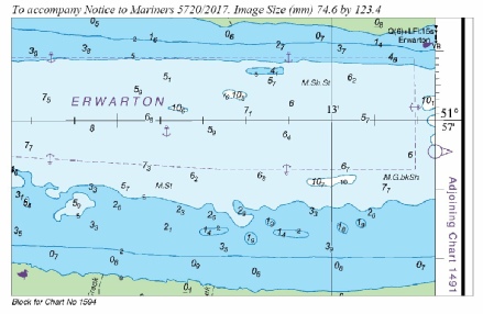
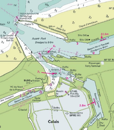
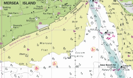
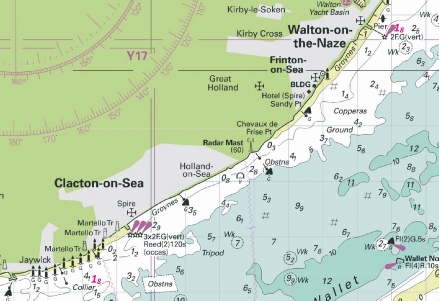


 Q(9)15s


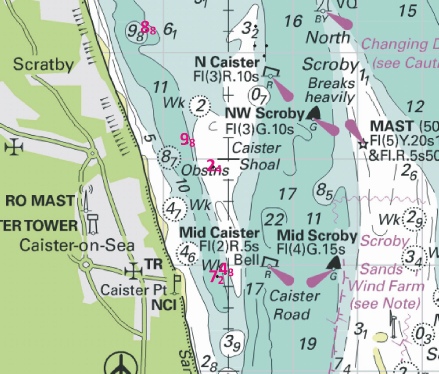
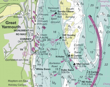
 Q(6)+LFl.15s Oikos at
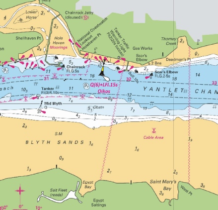
 at 51° 17´·39N., 2° 58´·47E. and 51° 17´·32N., 2° 56´·47E.
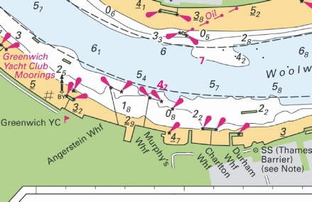
 Obstn
Obstn 
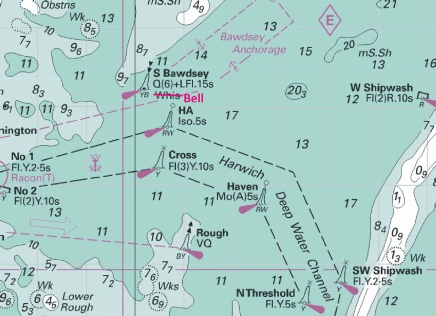
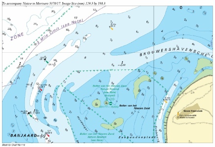
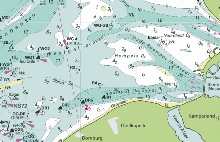
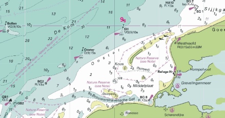
 VQ(9)10s H.F.Gravelines
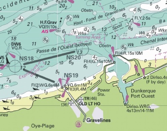
 at 51° 29´·495N., 0° 01´·820W.
  at 51° 29´·464N., 0° 01´·796W.
 VQ(3)5s
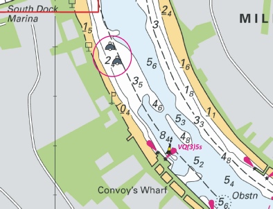
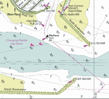
 Mo(U)Y.15s CB19
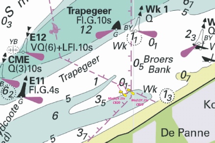
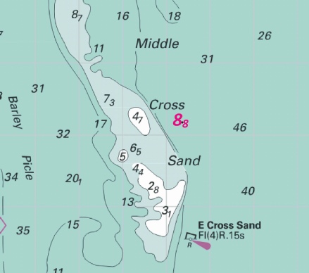
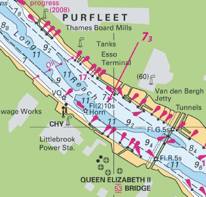
 Steenbank
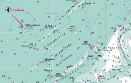
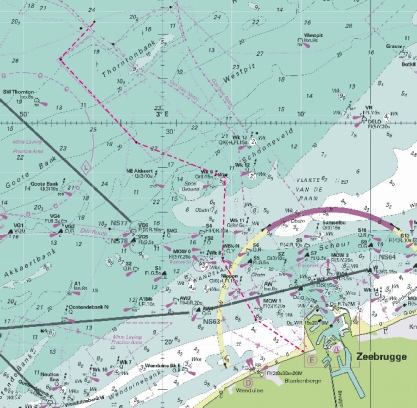
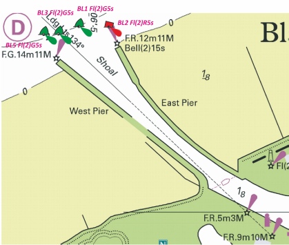
 Wk
Wk  Wk
Wk 
 Wk
Wk 


 CHY (167) at 51° 27´·35N., 0° 23´·33E, and

 ,
,  at 51° 17´·42N., 1° 29´·66E.
 ,
, 

 Whitaker (10), with
  at 51° 39´·65N., 1° 06´·17E.
  East Barrow (11), with
  Middle Sand (10), with
  Margate Hook (11), with
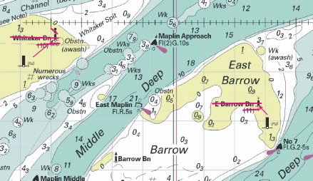
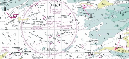


 Fl.Y.5s HBL
 3F.G(vert) at 51° 06´·981N., 1° 18´·858E.
  ·Q.G at 51° 06´·920N., 1° 19´·026E.

 , with
  at 51° 25´·795N., 0° 39´·629E.
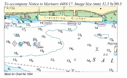


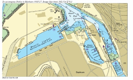
 at 52° 27´·01N., 1° 49´·55E.


 Q(6)+LFl.15s V@S-
 Fl.Y.5s V@S2

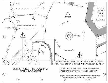
 at 52° 25´·2N., 1° 49´·7E.

 at:
at: )
)


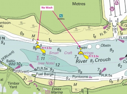
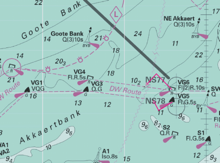


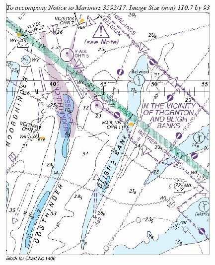
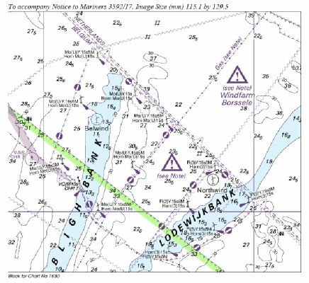
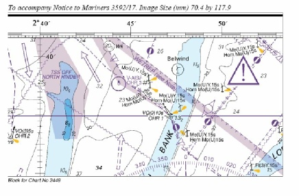

 at
at
 at 52° 18´·51N., 1° 46´·82E.
 at 52° 19´·76N., 1° 47´·58E.

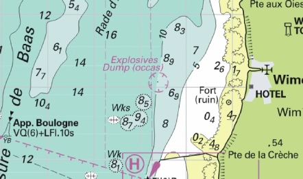


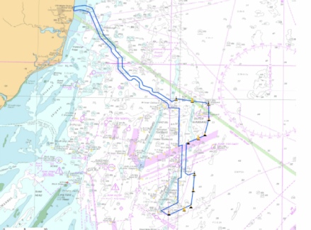

 P 1A
P 1A  Iso.R.8s P 4A
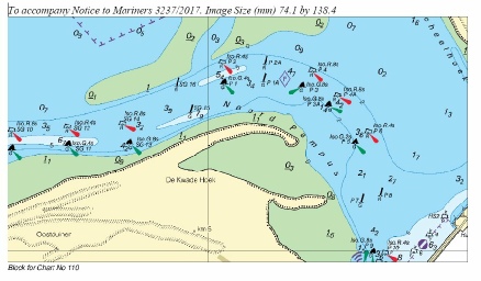

 Q.Y
Q.Y 
 Fl.Y.5s HD4
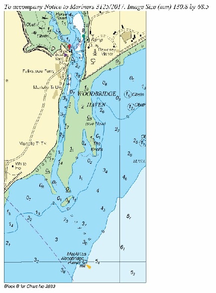
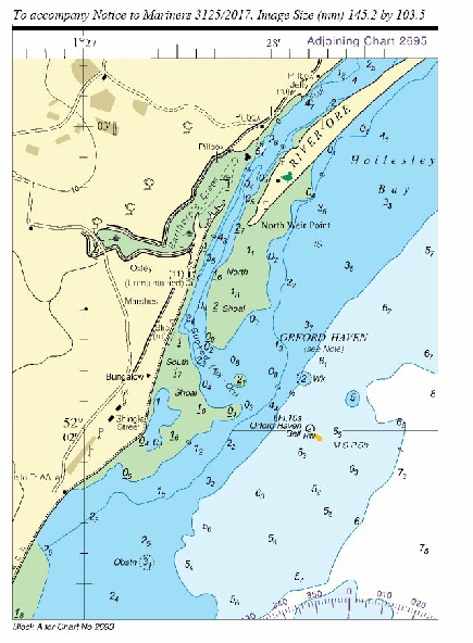
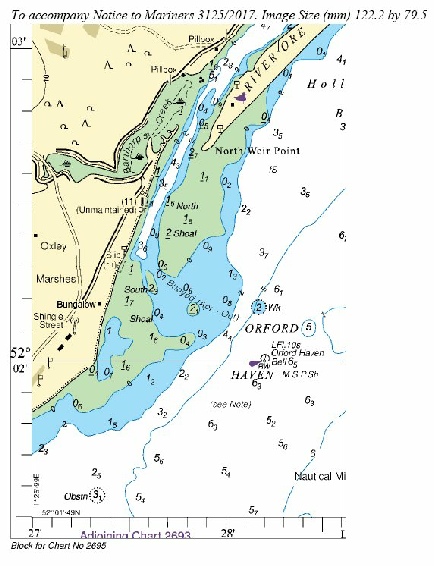
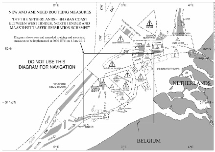
 Fl(4)Y.20s DY4


 at 51° 29´·800N., 0° 04´·467E.


 Fl.Y.3s


 VQ(9)10s Bollen
 at 51° 37´·08N., 3° 23´·88E.


 Mo(A)15s Woodbridge Haven


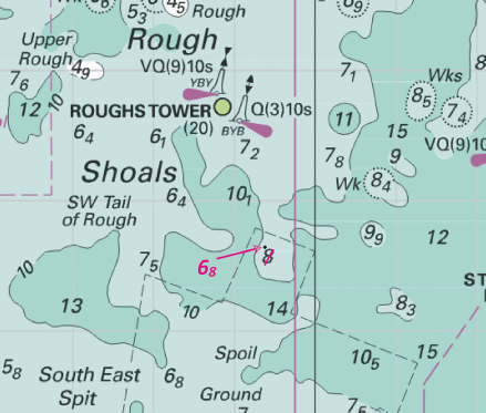


 No 6
No 6 


 Wk
Wk  Wk
Wk  Wk
Wk 

 at 51°19´·7N., 1°41´·6E.
 Beacon Hill (Apr-
 Iso.G.2s at 51°06´·895N., 1°18´·933E.


 Wk
Wk  Wk
Wk  Wk
Wk  Wk
Wk  Wk
Wk  Wk
Wk 
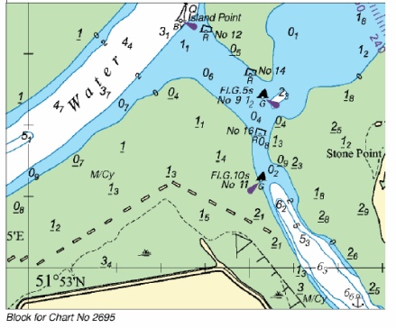
 Fl(5)Y.20s


 Wk
Wk


 VQ(3)5s RAF No 4 Tide Gauge at 52° 52´·54N., 0° 13´·10E. Delete
  close W.
 Fl(2)Y.5s Cable
 RAF No 5, with
  Fl(2)Y.5s RAF No 5 at 52° 51´·39N., 0° 13´·00E.


 intake, , joining: 51° 01´·24N., 2° 10´·75E. to 51° 01´·27N., 2° 10´·81E. (shore)
 at 51° 01´·25N., 2° 10´·74E. and 51° 01´·23N., 2° 10´·77E.
 at 51° 20´·193N., 0° 54´·244E.
 Fairway No 1


 Wk Historic Wk (see Note) at


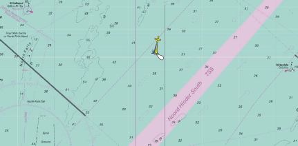
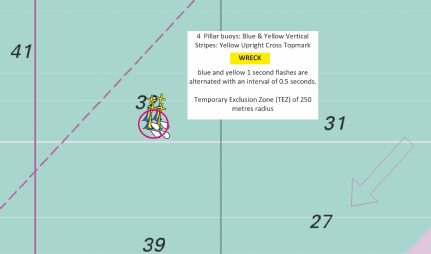
 Wk
Wk
 Wk
Wk
 Wk
Wk


 Wk
Wk 
 at
at 

 VQ Lynn WF N
  Fl.Y.2·5s Lynn WF NW
  VQ(9)10s Lynn WF W
  VQ(6)+LFl.10s Lynn WF S