|
2024 Permanent/Temporary/Preliminary UKHO Notices to Mariners - |
||
|
Week 20 |
New Editions of ADMIRALTY Charts to be published on 30th May, 2024 Chart 1543 England - |
Includes changes to depths from the latest British Government and Trinity House surveys. |
|
Week 20 |
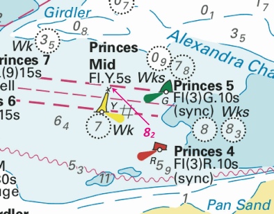
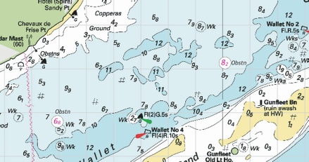
ENGLAND - Insert: depth, 8.2 at 51° 29´·44N., 1° 09´·14E. Delete depth, 7.7, close NW. Notice 2117 refers Base image courtesy of Imray ID10 Chart IN5043 and Meridian Chartware.
|
Affects: UKHO SNC: 1606, 1607 and 1609. UKHO SCC: 5606.5 Imray Full Charts: C1 Imray Leisure Folios 2100.1 One reduction of depth just inside the channel of the Princes Channel between Princes No 5 and No7. Unlikely to hinder leisure craft.
|
|
Week 20 |
NORTH SEA - Insert: limit of restricted area, entry prohibited, , pecked line, joining: (a) 51° 31´·59N., 2° 28´·55E. (b) 51° 32´·53N., 2° 29´·69E. (c) 51° 31´·82N., 2° 31´·21E. (d) 51° 30´·87N., 2° 30´·06E. symbol, Notice 2123 refers Base image courtesy of Imray ID10 Chart C30 and Meridian Chartware
. |
Affects: UKHO SNC: 1630 Imray Full Charts: C30 Last week, NtM 2008 announced a family of four cardinal buoys (one each) marking the site of the ‘soon to come’ Princess Elisabeth Island west of the Westhinder bank. This notice announces the area marked by the buoys are now ‘entry prohibited. New image.
|
|
Week 20 |
NETHERLANDS - Replace:
Notice 2134 refers Base image courtesy of Imray ID10 Chart C2120.7 and Meridian Chartware.
|
Affects: UKHO SNC: 110 (Panel B, Slijkgat to Stellendam) Imray Full Charts: C30 Imray Leisure Folios 2120.7 Light characteristics are added to two previous unlit buoys in the heavily marked channel from Slijkgat to Stellendam.
|
|
Week 19 |
New Editions of ADMIRALTY Charts to be published on 23rd May, 2024 Chart 1534 - A Great Yarmouth Outer Harbour. 1:7,500 B Great Yarmouth Haven. 1:7,500 Chart 1535 - Lowestoft Harbour. 1:6,250 |
Includes changes to depths from the latest British Government, Trinity House and Great Yarmouth Port Authority surveys. |
|
Week 19 |
NORTH SEA - Insert:
Notice 2008 refers Base image courtesy of Imray ID10 Chart C30 and Meridian Chartware.
|
Affects: UKHO SNC: 1630. Imray Full Charts: C30 This notice announces a family of four cardinal buoys (one each) marking the site of the ‘soon to come’ Princess Elisabeth Island. This is located west of the Westhinder bank and east of the NE going TSS. NtM 783 placed two yellow special buoys earlier this year in the same location. The Belgium plan is from the ELIA group and the oject is to create an energy hub which will connect UK, Belgium and Norway. I have linked a brochure with the usual pdf image download. The island is to be built from now to mid 2026 and then the energy hub will be built. The location is probably unlikely to hinder leisure craft given that crossing over the Westhinder bank is best avoided.
|
|
Week 19 |
ENGLAND - Insert:
Notice 2019 refers Base image courtesy of Imray ID10 Chart C1 and Meridian Chartware.
|
Affects: UKHO SNC: 1183 and 1975. UKHO SCC: 5607.4 and 5607.2. Imray Full Charts: C1 Imray Leisure Folios 2000.1 This notice is probably the product of the detailed survey that the Northern Wind undertook at the end of last year. Two new obstructions off Clacton and Frinton. Both in plenty of water for us so unlikely to hinder leisure craft – but of course might be a good lobster pot place! Traditionally pots in this area are poorly marked by some!
|
|
Week 19 |
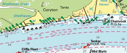
ENGLAND - Replace: depth, 0.1, with circular limit of 0m low water line, radius 30m, centred on: 51° 30´·46N., 0° 32´·59E. depth, 2.4, with depth, 0.6, enclosed by 2m contour 51° 30´·451N., 0° 32´·493E. Insert: depth, 7.7, and extend 10m contour S to enclose 51° 30´·407N., 0° 31´·338E. depth, 5.5, and extend 10m contour S to enclose 51° 30´·423N., 0° 31´·498E. depth, 3.5, and extend 5m contour S to enclose 51° 30´·438N., 0° 31´·618E. Delete depth, 4.4, close W. depth, 3.9, enclosed by 5m contour 51° 30´·438N., 0° 31´·690E. depth, 3.4, and extend 5m contour S to enclose 51° 30´·450N., 0° 31´·752E. depth, 8.8 at 51° 30´·422N., 0° 31´·806E. Delete depth, 9.6, close W. depth, 7.3 at 51° 30´·429N., 0° 31´·881E. Delete depth, 7.5, close NE. drying height, 0.8, and extend 0m low water line S to enclose 51° 30´·486N., 0° 31´·986E. Delete depth, 1.1, close W. depth, 9.1, and extend 10m contour S to enclose 51° 30´·429N., 0° 32´·444E. depth, 11.4 at 51° 30´·419N., 0° 32´·618E. Delete depth, 12.2, close W. depth, 0.2, enclosed by 2m contour at 51° 30´·454N., 0° 32´·696E. Delete depth, 5.9, close SE. Notice 2038 refers Base image courtesy of Imray ID10 Chart IN5036 and Meridian Chartware.
|
Affects: UKHO SNC: 1185 and 1186 (INT 1426) (Panel A, Canvey Island to Coalhouse Point) UKHO SCC: 5606.8 Imray Full Charts: C2 Imray Leisure Folios 2100.2 and 2100.3 This notice has 13 reductions of depth of which one is a drying height but all are located in the commercial area alongside the jetties of Shellhaven, Coryton and Chainrock. Illustrating the changes are impractical at the scale available and are unlikely to be anywhere leisure craft should be so for the first time I am breaking my usual practice.
|
|
Week 19 |
ENGLAND - Insert:
depth, 0.5 at 51° 42´·62N., 1° 30´·92E. Delete depth, 1.7, close SE. depth, 06, enclosed by 2m contour at 51° 42´·52N., 1° 30´·62E. Delete depth, 4, close S. depth, 2.8 at 51° 39´·71N., 1° 37´·81E. Delete depth, 7, close SW and depth, 3.5, close SW. depth, 4.3, and extend 5m contour SE to enclose 51° 38´·82N., 1° 37´·65E. Delete depth, 8.3, close NW. depth, 4.4, and extend 5m contour NE to enclose 51° 38´·32N., 1° 37´·70E. Delete depth, 7.1, close NE. depth, 4.3, and extend 5m contour SE to enclose 51° 40´·63N., 1° 38´·11E. Delete depth, 6.6, close S. depth, 2.9, and extend 5m contour SE to enclose 51° 39´·49N., 1° 37´·73E. Delete depth, 7, close SW. Notice 2107 refers Base image courtesy of Imray ID10 Chart C1 and IN5043 and Meridian Chartware.
|
Affects: UKHO SNC: 1183 and 1975. UKHO SCC: 5607.4 and 5607.2. Imray Full Charts: C1 Imray Leisure Folios 2000.1 Two new wrecks on the Gunfleet Sands between the east side of the wind farm and the Old Gunfleet Lighthouse. Probably unwise to try to cross the sands at that point. The Notice also has seven reductions of depth, two very shallow depths on the Long Sand, east side of the London Array wind farm and five reductions of depth along the east side of the Kentish Knock. Probably unwise to cross the Long Sand just east of the wind farm. Three images: of the second image at the Long Sand three other reductions of depth reported by the earlier Notice 1880 has been included.
|
|
Week 18 |
New Editions of ADMIRALTY Charts to be published on 16th May, 2024 SN Chart 1698 - |
Includes amendments to depths from latest Port Authority surveys. |
|
Week 18 |
ENGLAND - Insert: depth, 8.2, and extend 10m approximate contour SE to enclose 52° 42´·10N., 1° 45´·81E. Delete depth, 8.6, close NW. depth, 15.7, and extend 20m contour E to enclose 52° 41´·72N., 1° 46´·54E. depth, 11.8, and extend 15m contour E to enclose 52° 41´·44N., 1° 46´·00E. depth, 7.4, and extend 10m contour E to enclose 52° 41´·24N., 1° 46´·84E. Delete depth, 9.3, close NW. depth, 13.7, and extend 15m contour NE to enclose 52° 41´·28N., 1° 47´·02E. Delete depth, 15.5, close N and depth, 15.3, close SE. depth, 12.5, and extend 15m contour N to enclose 52° 40´·73N., 1° 47´·50E. depth, 5.5, enclosed by 10m contour at 52° 37´·55N., 1° 49´·14E. depth, 7.2, enclosed by 10m contour at 52° 37´·04N., 1° 49´·15E. depth, 5.7, enclosed by 10m contour at 52° 36´·86N., 1° 49´·13E. depth, 3.2, enclosed by 5m contour at 52° 36´·69N., 1° 49´·01E. depth, 12.8, enclosed by 15m contour at 52° 36´·55N., 1° 49´·16E. depth, 9.7, and extend 10m contour E to enclose 52° 36´·32N., 1° 49´·02E. Delete depth, 17.5, close SE. depth, 4.7, enclosed by 5m contour at 52° 34´·77N., 1° 48´·62E. Delete depth, 11.2, close NW. depth, 3.7, and extend 5m contour W to enclose 52° 34´·63N., 1° 48´·71E. Delete depth, 7.5, close NE. Notice 1974 refers Base image courtesy of Imray ID10 Chart C28 and Meridian Chartware.
|
Affects: UKHO SNC: 1534, 1535 and 1543.. UKHO SCC: 5614.4 (Panel A, Approaches to Great Yarmouth, 5614.5 (Panel A, Northern Approaches to Great Yarmouth) and Chart 5614.6 (Panel A, Caister- Imray Full Charts: C28 14 reductions of depth, 6 in and around the Hemsby and North Scroby buoys, six on the eastern side of the Scroby Sands and 2 on the Corton Sand channel. All still have sufficient depths for leisure craft but the general trend is probably worth attention. In one area the eastern edge of the Scroby Sand is pretty steep. Two images:
|
|
Week 18 |
ENGLAND - depth, 0.9 at 51° 19´·818N., 1° 25´·376E. Delete depth, 1.5, close N. drying height, 0.9, and extend 0m low water line W to enclose 51° 19´·672N., 1° 25´·343E. Delete depth, 0.2, close SW. depth, 2.1 at 51° 19´·491N., 1° 25´·375E. Delete depth, 2.6, close SW. depth, 2.4 at 51° 19´·509N., 1° 25´·214E. Delete depth, 3.2, close NW. depth, 1.9, and extend 2m contour N to enclose 51° 19´·493N., 1° 25´·143E. Delete depth, 2.9, close SE. depth, 2.5 at 51° 19´·567N., 1° 25´·067E. Delete depth, 3.1, close SW and depth, 2.9, close S. depth, 2.9 at 51° 19´·583N., 1° 24´·914E. Delete depth, 3.5, close SW. Replace: depth, 2.8, with depth, 1.8, and extend 2m contour N to enclose 51° 19´·486N., 1° 25´·260E. depth, 3, with depth, 2.4 at 51° 19´·529N., 1° 25´·053E. Notice 1999 refers Base image courtesy of Imray ID10 Chart IN5015 and Meridian Chartware.
|
Affects: UKHO SNC: 1827 (Panel C, Ramsgate) and 1828 (Panel, Ramsgate). UKHO SCC: 5605.15 (Panel B, Ramsgate) and 5606.10 (Panel C, Ramsgate) Imray Full Charts: C8F Imray Leisure Folios 2100.11A (Ramsgate) 9 reductions of depth within Ramsgate Harbour. One (0.9m) is within the Royal Harbour close to the east pontoon of the East Marina, one is a drying height within the entrance of the Royal Harbour and the remainder are in the ‘Turning Basin’. There were 4 other reductions of depth in the Turning Basin area vide NtM 1029 earlier this year so the image includes all the new soundings. Two images:
|
|
Week 18 |
EAST COAST OF ENGLAND - Longsand Head Lighted Buoys On or around the 17th May 2024, the following alterations to buoyage will take place: Longsand Head Lighted Buoy To be moved to new position: Latitude 51° 48.366’N., Longitude 001° 38.160’E. East Longsand Head Lighted Buoy New station to be deployed in position: Latitude 51° 48.123’N., Longitude 001° 39.394’E. Characteristics as below: Pillar: Black above Yellow above Black Q (3) 10s East Cardinal Topmark AIS Transmission: MMSI 992351455 “EAST LONGSAND HEAD BUOY” Movement effected consequent upon a recent survey. Further notice will be given upon buoy deployment. Trinity House Notice to Mariners, 17/04/2024 No 05 of 2024 refers
|
Affects: UKHO SNC: 1183, 1607, 1975.and 2692 UKHO SCC: 5607.2. Imray Full Charts: C1 Imray Leisure Folios 2000.1 This Trinity House Notice gives advance information of changes at the Long Sand Head. On or around 17th May there is a move and a new buoy. Close to the current position of the Longsand Head north cardinal buoy, a new east cardinal buoy will be positioned designated 'East Longsand Head' Light characteristics are shown. Also AIS will be fitted. The Longsand Head north cardinal buoy is moved to the West providing clearance round the Long Sand Head. The image is drawn by me based on Imray showing all recent depths and the intended positions.
|
|
Week 17 |
ENGLAND - Insert: depth, 1 , and extend 2m approximate contour E to enclose 51° 42´·46N., 1° 33´·17E. depth, 0.9 , and extend 2m approximate contour SE to enclose 51° 42´·16N., 1° 32´·86E. depth, 1.1, and extend 2m approximate contour S to enclose 51° 41´·93N., 1° 32´·42E. Delete depth, 3.5, close SW. depth, 0.1 , enclosed by 2m contour 51° 36´·42N., 1° 35´·15E. Delete depth, 5.2, close SE. depth, 0.9 , enclosed by 2m contour 51° 36´·17N., 1° 34´·69E. Delete depth, 8.1, close SW. depth, 0.7 , enclosed by 2m contour 51° 36´·49N., 1° 35´·44E. Notice 1880 refers Base image courtesy of Imray ID10 Chart C1 and Meridian Chartware.
|
Affects: UKHO SNC: 1183, 1607 and 1975. UKHO SCC: 5607.2. Imray Full Charts: C1 Imray Leisure Folios 2000.1 Six reductions of depth, three on the Long Sand and three on the Kentish Knock. The soundings on the Long Sand are outside the Wind Farm to the NE. The three on the Kentish Knock are just outside the south side of the Wind Farm and quite dramatic: i.e. fro8.1m to 0.9. But probably not where we usually go.
|
|
Week 16 |
New Editions of ADMIRALTY Small Craft Charts to be published 18 April 2024 SCC 5614.7 A Cromer to Wells- B Wells- New Editions of ADMIRALTY Small Craft Charts to be published 2 May 2024 SCC 5614.8 Outer Approaches to The Wash. 1:150,000 SCC 5614.9 Approaches to The Wash. 1:75,000 |
Includes full updates for New Edition and Notices to Mariners affecting source charts. Includes full updates for New Edition and Notices to Mariners affecting source charts. |
|
Week 16 |
ENGLAND - Insert: depth, 2.2 at 51° 47´·88N., 1° 37´·22E. Delete depth, 4.5, close NE. depth, 6.9 at 51° 48´·09N., 1° 37´·87E. depth, 11 at 51° 48´·26N., 1° 38´·16E. Notice 1784 refers Base image courtesy of Imray ID10 Chart C1 and Meridian Chartware.
|
Affects: UKHO SNC: 2692. UKHO SCC: 5607.2. Imray Full Charts: C1 Imray Leisure Folios 2000.1 Three new reduced depths for SNC 2692 at the Long Sand Head. A new edition of SNC 2692 was only issued on 28th March! The reduced depths indicate that the Long Sand Head continues the common trend to extend to the NE. I understand it is likely the Long Sand Head North Cardinal which is critical marking the tight corner in the two-
|
|
Week 16 |
ENGLAND - Insert: depth, 8.8, and extend 10m contour SE to enclose 51° 27´·392N., 0° 26´·394E. Delete depth, 8.7, close NW. Notice 1807 refers Base image courtesy of Imray ID10 Chart IN5036 and Meridian Chartware.
|
Affects: UKHO SNC: 1186 (Panel A, Canvey Island to Coalhouse Point). UKHO SCC: 5606.13 (Panel A, Hole Haven to Gravesend Reach) Imray Full Charts: C2 Imray Leisure Folios: 2100.3A An unusual event here; a NtM reporting an increase of depth. One very slight increase of depth in the River Thames in the south end of the Lower Hope Reach just south of the Ovens SHB. Unlikely to hinder leisure craft.
|
|
Week 15 |
ENGLAND - Insert: depth, 18.1, and extend 20m contour W to enclose 51° 08´·31N., 1° 28´·35E. Replace: depth, 17.1, with depth, 15.3 at 51° 08´·34N., 1° 28´·65E. Notice 1566 refers Base image courtesy of Imray ID10 Chart IN5007 and Meridian Chartware.
|
Affects: UKHO SNC: 323 and 1892. UKHO SCC: 5605.7 and 5606.3. Note: This update is included in New Edition 5605.8, published 28 March 2024. Imray Full Charts: C8 Imray Leisure Folios 2100.1 Two reduction of depth just SW of the Southwest Godwin cardinal. Ample water for leisure craft so unlikely to hinder.
|
|
Week 15 |
ENGLAND - Insert: depth, 16.3 at 51° 51´·20N., 1° 36´·22E. Delete depth, 17.1, close E. depth, 16.6 at 51° 51´·12N., 1° 36´·57E. Delete depth, 17.1, close NW. Notice 1597 refers Base image courtesy of Imray ID10 Chart C1 and Meridian Chartware.
|
Affects: UKHO SNC: 1183 and 1975. Note: This update is included in New Edition 2692, published 28 March 2024. UKHO SCC: 5607.2 Imray Full Charts: C1 Imray Leisure Folios 2000.1 Two reductions of depth; this monitoring the DW channel on the Sunk Inner area. Unlikely to hinder leisure craft. The image includes a reduced depth vide NtM 1470 previously.
|
|
Week 15 |
ENGLAND - Insert: depth, 2.7, and extend 5m contour S to enclose 51° 32´·43N., 1° 01´·64E. Delete depth, 4, close NW. depth, 6.2 at 51° 32´·53N., 1° 01´·95E. Delete depth, 6.7, close SW depth, 2.7 at 51° 32´·44N., 1° 01´·60E. Delete depth, 4, close SE. depth, 5.5 at 51° 32´·34N., 1° 01´·23E. Delete depth, 7.2, close SW. depth, 6.1 at 51° 32´·21N., 1° 00´·75E. Delete depth, 7, close E. Replace: depth, 6.5, with depth, 6 at 51° 32´·65N., 1° 02´·22E. depth, 9.1, with depth, 8.6 at 51° 32´·38N., 1° 01´·58E. depth, 1.7, with depth, 1.2, and extend 2m approximate contour S to enclose 51° 32´·43N., 1° 01´·51E. depth, 4.4, with depth, 2.7, and extend 5m contour S to enclose 51° 32´·40N., 1° 01´·47E. Notice 1608 refers Base image courtesy of Imray ID10 Chart IN5043 and Meridian Chartware.
|
Affects: UKHO SNC: 1607 and 1609. UKHO SCC: 5606.6 Imray Full Charts: C1 Imray Leisure Folios 2100.1 Nine reductions of depth at the Mouse channel side of the SW Barrow knoll. If you are a ‘corner cutter’ round the knoll (e.g. to or from the Princes Channel into the West Swin) it is worth seeing the image. Note the edge of that sand is pretty ‘steep-
|
|
Week 15 |
ENGLAND - Insert: depth, 3.1, and extend 5m contour SE to enclose 52° 31´·21N., 1° 48´·69E. Delete depth, 4.5, close N. depth, 3.3, and extend 5m contour SE to enclose 52° 30´·28N., 1° 48´·34E. Delete depth, 3.1, close NW. depth, 9.6, and extend 10m contour S to enclose 52° 29´·78N., 1° 49´·70E. depth, 2.2, and extend 5m contour N to enclose 52° 34´·07N., 1° 49´·18E. Delete depth, 4.6, close E. Notice 1641 refers Base image courtesy of Imray ID10 Chart C28 and Meridian Chartware.
|
Affects: UKHO SNC: 1534, 1535 and 1543. UKHO SCC: 5614.3 and 5614.4 (Panel A, Approaches to Great Yarmouth) Imray Full Charts: C28 Four reductions of depth, three on the east side of the Holm Sand just north of Lowestoft and one on the east side of the Mid Corton Sand off Great Yarmouth.
|
|
Week 15 |
ENGLAND - Insert: pontoon, single firm line, joining: 51° 30´·271N., 0° 04´·195W. 51° 30´·273N., 0° 04´·192W. 51° 30´·262N., 0° 04´·159W. 51° 30´·259N., 0° 04´·162W. Notice 1648 refers Base image courtesy of Imray Chart IN5030 and Meridian Chartware.
|
Affects: UKHO SNC: 3337. UKHO SCC: 5606.15A Imray Full Charts: C2 Imray Leisure Folios 2100.4B A new pontoon in the River Thames at the Pool, just upstream of the Hermitage Wharf pontoon.
|
|
Week 15 |
ENGLAND - Insert: depth, 3.4 at 51° 31´·036N., 0° 08´·036E. Delete depth, 3.7 , close W. Notice 1655 refers Base image courtesy of Imray ID10 Chart IN5036 and Meridian Chartware.
|
Affects: UKHO SNC: 2151 (Panel A, Continuation at same scale). UKHO SCC: 5606.14B Imray Full Charts: C2 Imray Leisure Folios 2100.4A One reduction of depth in the River Thames, at Horseshoe Corner in Halfway Reach. Unlikely to hinder leisure craft.
|
|
Week 14 |
BELGIUM - Yellow special purpose light- Characteristic Designation Buoy Type Position Fl.Y.5s HD26 Conical 51° 14´·22N., 2° 48´·62E. Fl.Y.5s HD25 Conical 51° 12´·58N., 2° 50´·35E. Notice 1459(T) refers Base image courtesy of Imray ID10 Chart C2120.3 and Meridian Chartware.
|
Affects: UKHO SNC: 1872, 1873, 1874 and 2449. UKHO SCC: 5605.11 Imray Full Charts: C30 Imray Leisure Folios 2120.3 This temporary Notice is placing two new Yellow special lit buoys very close to existing similar buoys either side of the Stroombank west of Ostendee.
|
|
Week 14 |
ENGLAND - Insert: depth, 15.8 at 51° 51´·50N., 1° 36´·12E. Delete depth, 16.2, close SE. Notice 1470 refers Base image courtesy of Imray ID10 Chart C1 and Meridian Chartware.
|
Affects: UKHO SNC: 1975. Note: This update is included in New Edition 2692, published 28 March 2024. UKHO SCC: 5607.2 Imray Full Charts: C1 Imray Leisure Folios 2000.1 One reduction of depth NE of the Sunk Inner Mark in line with the DW channel leading to the exit to Felixstowe. Unlikely to hinder leisure craft.
|
|
Week 14 |
ENGLAND - Insert:
Automatic Identification System, AIS, at light, and legend, Bird Nesting Structure, close SE. at 52° 14´·28N., 1° 39´·02E.
Automatic Identification System, AIS, at light at 52° 27´·63N., 1° 45´·80E. Delete:
Automatic Identification System, AIS, at light, and legend, Bird Nesting Structure, close NE at 52° 27´·72N., 1° 45´·82E. Delete:
Notice 1502 refers Base image courtesy of Imray ID10 Chart C1 and Meridian Chartware.
|
Affects: UKHO SNC: 1504, 1535, 1543 and 1610. UKHO SCC: 5614.1 (Panel A, Orford Ness to Benacre Ness) and 5614.2 Imray Full Charts: C28 This notice confirms the Preliminary Notice 2318(T) of last year. This marks the three Bird Nesting Structures, two off Lowestoft, the third, off Minsmere. The Notices adds AIS on all three Structures and a legend on charts. Light characteristics remain as reported last year.
|
|
Week 14 |
BELGIUM - Amend: range of light to, 11M at: 51° 09´·35N., 2° 43´·00E, and 51° 09´·42N., 2° 43´·08E. Notice 1475 refers Base image courtesy of Imray ID10 Chart C30B and Meridian Chartware.
|
Affects: UKHO SNC: 2449. Imray Full Charts: C30B Imray Leisure Folios 2120.3 and 2120.3A The pair of lights either side of the entrance into Nieuwpoorte is increased to 11M.
|
|
Week 14 |
NETHERLANDS - Insert:
Move:
Notice 1512 refers Base image courtesy of Imray ID10 Chart C2120.7 and Meridian Chartware.
|
Affects: UKHO SNC: 110 (Panel B, Slijkgat to Stellendam).. Imray Full Charts: C30 Imray Leisure Folios 2120.7 This, a quite involved notice providing details of new buoys and moved buoys at the entrance of the Slijkgat which leads to Stellendam. The changes have added two pairs of lateral buoys. The annotations on the image is quite involved but the message is that there is a very clearly marked channel with 18 paired lateral buoys.
|
|
Week 13 |
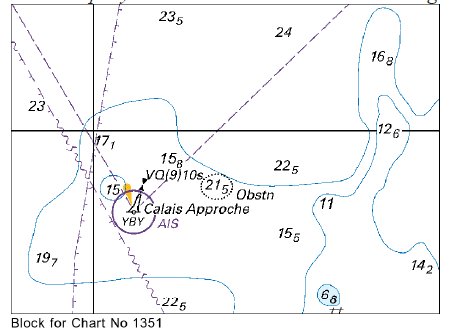
DOVER STRAIT - Insert: depth, 15.3 at 51° 21´·10N., 2° 17´·78E. Delete depth, 15.7, close NE and depth, 16.9, close SE. depth, 17.6, and extend 20m E to enclose 51° 20´·68N., 2° 18´·74E. depth, 29.5, and extend 30m contour NW to enclose 51° 17´·06N., 2° 14´·15E. Delete depth, 32, close NW. depth, 21.5 at 51° 16´·50N., 2° 14´·80E. Delete depth, 24.5, close E. depth, 26.5 of 51° 16´·32N., 2° 05´·80E. Delete depth, 28.5, close NE and N and depth, 28, close W. depth, 29, and extend 30m contour SE to enclose 51° 15´·89N., 2° 05´·83E. Chart 1351 Insert the accompanying block, centred on: 50° 59´·0N., 1° 45´·3E. Notice 1351 refers Base image courtesy of Imray ID10 Chart C30 and Meridian Chartware. The block is copyright of the UKHO
|
Affects: UKHO SNC: 323, 1351, 1406, 1610, 1872, 1873 and 2449. UKHO SCC: 5605.2, 5605.1 (Panel B, Northern Approaches to Dover Strait), 5606.1 and 5607.1 Imray Full Charts: C8 Imray Leisure Folios 2110.2 Six reduced depths in the West Hinder and Sandiettie TSS and a new UKHO block around the Calais Approche west cardinal buoy. This is deep water so should not hinder leisure craft. 2 reductions just south of the Fairybank S. south cardinal buoy and 4 reductions in the Sandiettie TSS in the junction area with the West Hinder TSS. Ample water also around the Calais west cardinal.
|
|
Week 13 |
ENGLAND - Move:
to: 52° 41´·56N., 1° 46´·53E. Notice 1367 refers Base image courtesy of Imray ID10 Chart C28 and Meridian Chartware.
|
Affects: UKHO SNC: 1534 and 1543. UKHO SCC: 5614.2, 5614.5 (Panel A, Northern Approaches to Great Yarmouth) and 5614.6 (Panel A, Caister- Imray Full Charts: C28 The North Scroby north cardinal buoy has been moved a small distance to the north. The North Scroby sands break heavily.
|
|
Week 13 |
ENGLAND - Insert: depth, 9.9, enclosed by 10m contour at 51° 48´·42N., 1° 39´·17E. Delete depth, 10.7, close NW and depth, 10.3, close NW. depth, 10.2 at 51° 48´·63N., 1° 39´·41E. Delete depth, 11.1, close NW and depth, 10.7, close W. depth, 14, enclosed by 15m contour at 51° 49´·84N., 1° 36´·46E. Delete depth, 15.9, close W. Replace: depth, 10.1, with depth, 9.4, enclosed by 10m contour 51° 50´·02N., 1° 35´·82E. Notice 1378 refers Base image courtesy of Imray ID10 Chart C1 and Meridian Chartware.
|
Affects: UKHO SNC: 1183, 1610 and 1975. Note: This update is included in New Edition 2692, published 28 March 2024. UKHO SCC: 5607.2 Imray Full Charts: C1 Imray Leisure Folios 2000.1 A reduction of depth, three of which are in the ‘turn’ of the Long Sand Head two-
|
|
Week 13 |
NORTH SEA - Insert: legend, Historic Wk (see Note), at wreck 51° 22´·88N., 2° 27´·13E. Notice 1390 refers Base image courtesy of Imray ID10 Chart C30 and Meridian Chartware
|
Affects: UKHO SNC: 1630 and 2449. UKHO SCC: 5606.2 and 5607.2 Imray Full Charts: C30 Imray Leisure Folios 2110.2 New legend recording an historic wreck close east of the Westhinder south cardinal buoy. The wrecks adjacent were added vide NtM 766/2024.
|
|
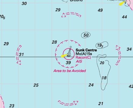
Week 13 |
ENGLAND - Amend: Sunk Centre light- Notice 1433 refers Base image courtesy of Imray ID10 Chart C1 and Meridian Chartware.
|
Affects: UKHO SNC: 1183. UKHO SCC: 5606.2 and 5607.2 Imray Full Charts: C1 This notice applies only to the small scale chart of the whole Thames Estuary (SNC 1183). The change is the light characteristics of the Sunk Centre safe water buoy. I believe most charts are all ready correct.
|
|
Week 13 |
ENGLAND - Insert: depth, 8.6, and extend 10m contour E to enclose 52° 37´·66N., 1° 45´·14E. Delete depth, 13, close SE. Notice 1434 refers Base image courtesy of Imray ID10 Chart C28 and Meridian Chartware.
|
Affects: UKHO SNC: 1534. UKHO SCC: 5614.5 (Panel A, Northern Approaches to Great Yarmouth) Imray Full Charts: C28 One single significant reduction of depth off shore north of Great Yarmouth. The reduction is just north of an outfall pipe. The end of the outfall is marked by a lit port hand buoy which also marks the lateral edge of the Caister Road.
|
|
Week 12 |
ENGLAND - Insert: depth, 8 at 51° 36´·23N., 1° 20´·53E. Delete depth, 8.3, close SW. depth, 8.2 at 51° 36´·12N., 1° 20´·28E. Delete depth, 8.6, close NE. depth, 4.9, and extend 5m approximate contour NE to enclose 51° 35´·50N., 1° 20´·82E. depth, 6.2 at 51° 35´·24N., 1° 21´·21E. Delete depth, 7.1, close SW. depth, 6.3 at 51° 35´·09N., 1° 21´·44E. Delete depth, 6.9, close SW. depth, 5.5 at 51° 35´·57N., 1° 20´·74E. Delete depth, 6.7, close NW. Replace: depth, 9.5, with depth, 9 at 51° 35´·67N., 1° 20´·74E. Notice 1222 refers Base image courtesy of Imray ID10 Chart IN5043 and Meridian Chartware.
|
Affects: UKHO SNC: 1606, 1607 and 1975. UKHO SCC: 5606.2 and 5607.2 Imray Full Charts: C1 Imray Leisure Folios 2100.1 and 2000.1 7 reduction of depth in Fisherman’s Gat. Still ample water for leisure craft and still just outside the west side of the buoyage. But note there is a just the suggestion that the drying patch of the Long Sand on the mid-
|
|
Week 12 |
ENGLAND - Insert: legend, Works in progress (2023), orientated 222°/42°, centred on: 52° 28´·407N., 1° 45´·454E. Notice 1224 refers Base image courtesy of Imray ID10 Chart C28H and Meridian Chartware.
|
Affects: UKHO SNC: 1535 (Panel A, Lowestoft Harbour). UKHO SCC: 5614.20 (Panel A, Lowestoft Harbour) Imray Full Charts: C28H ‘Works in progress (2023) to be annotated on the east side of Waveney Dock in Lowestoft Harbour.
|
|
Week 12 |
ENGLAND - Chart 1534, Chart 5614.4 (Panel A, Approaches to Great Yarmouth) and Chart 5614.5 (Panel A, Northern Approaches to Great Yarmouth) Insert: bridge, double firm line, width 27m, joining: 52° 35´·58N., 1° 43´·52E. 52° 35´·58N., 1° 43´·61E. Chart 1534 (Panel B, Great Yarmouth Haven) [ previous Insert: the accompanying block , centred on: 52° 35´·6N., 1° 43´·6E. Chart 5614.5 (Panel B, Great Yarmouth Haven) Insert: the accompanying block , centred on: 52° 35´·6N., 1° 43´·6E. Notice 1251 refers UKHP Blocks are copyright.
|
Affects: UKHO SNC: 1534, 1534 (Panel B, Great Yarmouth Haven). UKHO SCC: 5614.5 (Panel B, Great Yarmouth Haven). Imray Full Charts: C28 Two new UKHO blocks marking the new bridge now opened in Great Yarmouth Haven: one block is for a SN Chart, the other for a SC chart. Other SNC and SCCs are to be drawn in on charts.
|
|
Week 12 |
ENGLAND - Insert: depth, 1.4, and extend 2m contour SE to enclose 51° 26´·069N., 0° 42´·971E. Delete depth, 1.8, close NE. depth, 7.9 at 51° 26´·150N., 0° 43´·403E. Delete depth, 8.5, close NE. depth, 15.4 at 51° 26´·347N., 0° 43´·865E. Delete depth, 16.3, close SE. Notice 1254 refers Base image courtesy of Imray ID10 Chart IN5016 and Meridian Chartware.
|
Affects: UKHO SNC: 1185, 1834, 2482 and 3683. UKHO SCC: 5606.9, Chart 5606.10 (Panel A, Mouth of River Medway and West Swale) and Chart 5606.11 (Panel A, Saltpan Reach to Chatham Reach) Imray Full Charts: Y18 Imray Leisure Folios 2100.5 and 2100.2 Three reductions of depth in the River Medway, two are with ample water for leisure craft, the third is a sounding of 1.4m just off Grain Pier.
|
|
Week 12 |
ENGLAND - Insert: the accompanying block, centred on: 51° 30´·9N., 0° 08´·3E. Notice 1265 refers Block is copyright of the UKHO.
|
Affects: UKHO SNC: 2151 (Panel A, Continuation at same scale). UKHO SCC: 5606.2 and 5607.2 Imray Full Charts: C2 Imray Leisure Folios 2100.4A A new UKHO block for the River Thames, Halfway Reach off Dagenham.
|
|
Week 12 |
ENGLAND - Insert:
Notice 1295 refers Base image courtesy of Imray ID10 Chart C28 and Meridian Chartware.
|
Affects: UKHO SNC: 1503 and 1504. UKHO SCC: 5606.2 and 5607.2 Imray Full Charts: C28 New lit port hand buoy close inshore close to the Gas Terminals at Bacton, Norfolk.
|
|
Week 12 |
ENGLAND - Insert: depth, 4.2, and extend 5m contour NW to enclose 52° 28´·309N., 1° 45´·654E. Delete depth, 4.9, close SW. depth, 3.6, and extend 5m contour NW to enclose 52° 28´·273N., 1° 45´·593E. Delete depth, 4.9 , close NE. depth, 1.5, enclosed by 2m contour at 52° 28´·259N., 1° 45´·633E. Delete depth, 4.1, close SW, depth, 2.4, close SE and depth, 4.3, close W. Notice 1300 refers Base image courtesy of Imray ID10 Chart C28D and Meridian Chartware.
|
Affects: UKHO SNC: 1535 (Panel, Lowestoft Harbour) and 1535. UKHO SCC: 5614.20 (Panel A, Lowestoft Harbour) and 5614.3 Imray Full Charts: C28D and C28H. Three new reduced depths just outside the entrance of Lowestoft Harbour: two still have ample water but the third is at 1.5m, a significant reduced from 4+m on the Lowestoft Bank hindering access to or from the Stanford Channel. Worth noting. A depth of 4.9m is added from an earlier NtM this year
|
|
Week 12 |
ENGLAND - Insert: depth, 9 at 51° 53´·03N., 1° 31´·00E. Delete depth, 9.9, close NW. Notice 1304 refers Base image courtesy of Imray ID10 Chart C1 and Meridian Chartware.
|
Affects: UKHO SNC: 1183. Note: This update is included in New Edition 2692, published 28 March 2024. UKHO SCC: 5607.2 Imray Full Charts: C1 Imray Leisure Folios: 2000.1 One reduction of depth on the east edges of the Roughs Shoals. At 9m, unlikely to hinder leisure craft.
|
|
Week 12 |
ENGLAND - A dangerous wreck, with a least depth of 1·6m, has been reported in approximate position 51° 23´·623N., 0° 30´·244E. Mariners are advised to navigate with caution in the area. Former Notice 1891(T)/23 is cancelled. Notice 1219(T) refers Base image courtesy of Imray ID10 Chart Y18 and Meridian Chartware.
|
Affects: UKHO SNC: 1835 and 2482. UKHO SCC: 5606.11. Imray Full Charts: Y18 Imray Leisure Folios: 2100.5 A new dangerous wreck ‘amongst’ the moorings on the south- NtM 1107 earlier reported two other fouls close to this reported position.
|
|
Week 11 |
New Editions of ADMIRALTY Charts on 28th March, 2024 Standard National Charts Chart 2692 England - Small Craft Charts SCC 5605.8 Dover to Deal. 1:37,500 SCC 5605.9 Deal to Ramsgate. 1:37,500 SCC 5607.4 Southern Approaches to Harwich. 1:50,000 SCC 5607.5 Harwich to Orford Ness. 1:50,000 SCC 5607.6 A Approaches to Harwich and Woodbridge Haven. 1:25,000 B Continuation of River Deben. 1:25,000 SCC 5607.7 Rivers Stour and Orwell. A River Stour. 1:25,000 B River Orwell. 1:25,000 C Ipswich. 1:10,000 SCC 5607.8 A Rivers Ore and Alde. 1:25,000 B Orford Haven and Approaches. 1:25,000 |
Includes changes to depths from the latest British Government and Port of London Authority surveys. Includes full updates for New Edition and Notices to Mariners affecting source charts. |
|
Week 11 |
ENGLAND - Insert: symbol, overfalls at 52° 26´·29N., 1° 46´·84E. Notice 1190 refers Base image courtesy of Imray ID10 Chart C28 and Meridian Chartware.
|
Affects: UKHO SNC: 1535 and 1543. UKHO SCC: 5614.1 (Panel A, Orford Ness to Benacre) and 5614.2 Imray Full Charts: C28 A new ‘Overfalls’, a new symbols is placed just west of the Newcome Sand port hand buoy: i.e. the overfalls are just outside of the channel at the south entrance of the Stanford Channel to Lowestoft.
|
|
Week 10 |
ENGLAND - Insert: depth, 2.4 at 51° 42´·05N., 1° 25´·32E. Delete depth, 3.9, close N. depth, 0.7 at 51° 41´·83N., 1° 25´·65E. Delete depth, 0.9, close SW. depth 4.6, and extend 5m contour NW to enclose 51° 41´·75N., 1° 23´·95E. Delete depth, 6.7, close W. depth, 2.9 at 51° 41´·18N., 1° 24´·13E. Delete depth, 3.1, close SE. Notice 1026 refers Base image courtesy of Imray ID10 Chart IN5043 and Meridian Chartware.
|
Affects: UKHO SNC: 1183 and 1975. UKHO SCC: 5606.2 and 5607.2 Imray Full Charts: C1 Imray Leisure Folios 2100.1 and 2000.1 Four reductions of depth on the Little Sunk, two of which are on the usual crossing point and two indicating a slight growth of the Little Sunk knoll. This change is caused by our 2023 survey and the crossing point is NOT significantly affected. At the moment the growth of the Little Sunk appears to be quite slow, indeed the worse depth of 0.7m looked like the ‘crest’ of a sand wave.
|
|
Week 10 |
ENGLAND - Insert: depth, 4.9 , and extend 5m contour NW to enclose 52° 28´·294N., 1° 45´·607E. Notice 1027 refers Base image courtesy of Imray ID10 Chart C28D and Meridian Chartware.
|
Affects: UKHO SNC: 1535 and 1535 (Panel, Lowestoft Harbour). UKHO SCC: 5614.20 (Panel A, Lowestoft Harbour) and 5614.3 Imray Full Charts: C28D One reduction of depth in the approaches to Lowestoft Harbour entrance. Unlikely to hinder leisure craft.
|
|
Week 10 |
ENGLAND - Insert: drying height, 1.9 at 51° 24´·055N., 0° 33´·281E. Delete drying height, 0.7, close E. drying height, 0.2, and extend 0m low water line E to enclose 51° 24´·054N., 0° 33´·328E. depth, 0.5 at 51° 24´·037N., 0° 33´·349E. Delete depth, 1, close SE. depth, 5, enclosed by 5m contour at 51° 24´·102N., 0° 33´·478E. Delete depth, 5.3, close S. depth, 4.7 , enclosed by 5m contour at 51° 24´·068N., 0° 33´·518E. Delete depth, 5.1, close E. and depth, 5.6, close SW. depth, 4.8 , enclosed by 5m contour at 51° 24´·060N., 0° 33´·573E. Delete depth, 5.3 , close SW and depth 5.1, close W. Notice 1028 refers Base image courtesy of Imray ID10 Chart Y18 and Meridian Chartware.
|
Affects: UKHO SNC: 1835 and 2482. UKHO SCC: 5606.11 (Panel B, Saltpan Reach to Chatham Reach Imray Full Charts: Y18 Imray Leisure Folios 2100.5 Six reduction of depth (of which two are new drying heights) in the River Medway at the entrance of the Chatham Docks and the No 30 port hand buoy.
|
|
Week 10 |
ENGLAND - Insert: depth, 1.9, enclosed by 2m contour at 51° 19´·484N., 1° 25´·322E. Delete depth, 2.5, close E. depth, 2.7 at 51° 19´·534N., 1° 25´·287E. Delete depth, 2.9, close W. depth, 2.5 at 51° 19´·562N., 1° 25´·263E. Delete depth, 2.8, close NE. and depth, 3, close SW. depth, 2.6 at 51° 19´·566N., 1° 25´·147E. Delete depth, 3.1, close S. Notice 1029 refers Base image courtesy of Imray ID10 Chart IN5015 and Meridian Chartware.
|
Affects: UKHO SNC: 1827 (Panel C, Ramsgate). Note: This update is included in New Edition 1828, published 21/12/2023. UKHO SCC: 5605.15 (Panel B, Ramsgate) and 5606.10 (Panel C, Ramsgate) Imray Full Charts: C8F Imray Leisure Folios 2100.11.A Four reductions of depth in the Outer Harbour of the Port of Ramsgate. Whilst the revised depths are not great they should not hinder leisure craft.
|
|
Week 10 |
ENGLAND - Delete:
Notice 1076 refers Base image courtesy of Imray ID10 Chart Y9 and Meridian Chartware.
|
Affects: UKHO SNC: 1200, Note: This update is included in New Edition 108, published 22 February 2024. UKHO SCC: 5614.10 (Panel A, The Wash Eastern Part), 5614.11 (Panel A, The Wash Central Part and 5614.9. Imray Full Charts: Y9 The Yellow special lit buoy at the northerly tip of the Roaring Middle shoal in the centre of the Wash is deleted.
|
|
Week 10 |
ENGLAND - Replace:
Insert: depth, 1.7 , and extend 2m approximate contour E to enclose 52° 30´·93N., 1° 48´·54E. Delete depth, 7.1 , close NE. Notice 1082 Base image courtesy of Imray ID10 Chart C28 and Meridian Chartware.
|
Affects: UKHO SNC: 1535 and 1543. UKHO SCC: 5614.2. Imray Full Charts: C28 A wreck on the eastern side of the Holm Sand (off Lowestoft) is deleted and a reduced depth of 1.7m placed in lieu.
|
|
Week 10 |
ENGLAND - Insert:
Delete:
Notice 1083 refers Base image courtesy of Imray ID10 Chart Y9 and Meridian Chartware.
|
Affects: UKHO SNC: 1975 and 3750. UKHO SCC: 5606.6. Imray Full Charts: Y17B Imray Leisure Folios 2000.8 Note: Former Notice 1319(T)/23 is cancelled. This Notice is catching up with the changes of buoyage at the Ray Sand which occurred in 2023 as a result of surveys. The previous two Safe Water Buoys – the Raysand North and Raysand Middle are removed completely. A new unlit yellow buoy – The Raysand North is placed quite well to the East and the unlit round yellow Ray Sand buoy is moved to match the same longitude meridian. There is a CTTE download at on the Download page which provides the detailed chartlet with has had the correct buoyage since July last year. By all means use the free download. Use the 1° meridian to find the best water north of the Ray Sand between the River Blackwater and the Ray Sand. There are plans for a new edition of UKHO Chart 1975 Thames Estuary – Northern Part in the summer this year which should bring the contours up to date. As of today Navionics have placed the Ray Sand in the right place, have deleted the Raysand Middle, kept the Safe Water coloured Raysand North in the (wrong) old position and the Buxey Beacon in the wrong position. It tends to be handy to know where you are if you use Navionics. C-
|
|
Week 10 |
ENGLAND - Delete established direction of traffic flow arrow: On SN Chart 1185 direction 266° centred on: 51° 29´·49N., 0° 48´·89E. direction 282° centred on: 51° 29´·63N., 0° 44´·88E. direction 272° centred on: 51° 30´·16N., 0° 39´·51E. and 51° 30´·28N., 0° 34´·74E. direction 089° centred on: 51° 30´·10N., 0° 33´·05E. direction 092° centred on: 51° 29´·95N., 0° 38´·83E. direction 101° centred on: 51° 29´·36N., 0° 45´·12E. direction 086° centred on: 51° 29´·25N., 0° 48´·84E. On SN Chart 1186 (Panel A, Canvey Island to Coalhouse Point) direction 272° centred on: 51° 30´·249N., 0° 36´·121E. and 51° 30´·293N., 0° 34´·396E. direction 267° centred on: 51° 30´·315N., 0° 32´·755E. direction 260° centred on: 51° 30´·262N., 0° 31´·404E. direction 080° centred on: 51° 30´·025N., 0° 31´·585E. direction 090° centred on: 51° 30´·106N., 0° 32´·870E. direction 094° centred on: 51° 30´·047N., 0° 34´·337E. direction 093° centred on: 51° 30´·025N., 0° 36´·083E. On SN Chart 1606 direction 054° centred on: 51° 33´·47N., 1° 10´·06E. and 51° 32´·10N., 1° 07´·42E. direction 234° centred on: 51° 32´·33N., 1° 07´·21E. and 51° 33´·27N., 1° 10´·40E. On SN Chart 1607 direction 267° centred on: 51° 29´·61N., 0° 52´·37E. direction 086° centred on: 51° 29´·33N., 0° 51´·91E. On SN Chart 1609 direction 234° centred on: 51° 33´·47N., 1° 10´·07E. and 51° 32´·32N., 1° 07´·21E. direction 266° centred on: 51° 29´·56N., 0° 51´·42E. direction 088° centred on: 51° 29´·34N., 0° 51´·18E. direction 055° centred on: 51° 32´·08N., 1° 07´·42E. and 51° 33´·27N., 1° 10´·39E. On SC Chart 5606.7 direction 266° centred on: 51° 29´·49N., 0° 48´·89E. direction 282° centred on: 51° 29´·63N., 0° 44´·88E. direction 102° centred on: 51° 29´·36N., 0° 45´·12E. direction 086° centred on: 51° 29´·25N., 0° 48´·84E. On SC Chart 5606.8 direction 272° centred on: 51° 30´·16N., 0° 39´·51E. and 51° 30´·28N., 0° 34´·74E. direction 089° centred on: 51° 30´·10N., 0° 33´·05E. direction 092° centred on: 51° 29´·95N., 0° 38´·83E. On SC Chart 5606.9 direction 266° centred on: 51° 29´·49N., 0° 48´·90E. direction 282° centred on: 51° 29´·63N., 0° 44´·88E. direction 102° centred on: 51° 29´·36N., 0° 45´·12E. direction 086° centred on: 51° 29´·25N., 0° 48´·84E. On SC Chart 5606.5 direction 267° centred on: 51° 29´·61N., 0° 52´·37E. direction 086° centred on: 51° 29´·33N., 0° 51´·91E. Notice 1106 refers |
Affects: UKHO SNC: 1185, 1186 (Panel A, Canvey Island to Coalhouse Point), 1606, 1607 and 1609. UKHO SCC: 5606.7, 5606.8, 5606.9 and 5606.5 Imray Full Charts: C2 and C1 Imray Leisure Folios 2100.2 and 2100.1 This Notice deletes a total of 42 established direction of traffic flow arrows in the Sea Reach of the River Thames and the Outer Thames. This affects detailed 5 SN charts and 4 SC charts. If the Speaker can break conventions so can I, so I have not illustrated the changes on the grounds that this does not affect leisure craft.
|
|
Week 10 |
ENGLAND - Insert:
Delete:
Notice 1107 refers Base image courtesy of Imray ID10 Chart Y18 and Meridian Chartware.
|
Affects: UKHO SNC: 1835 and 2482 (Panel B, Rochester). UKHO SCC: 5606.11 (Panel B, Rochester). Imray Full Charts: Y18 Imray Leisure Folios 2100.6A A wreck in the middle of moorings in Bridge Reach just before Rochester Bridge is deleted and two ‘FOUL’ are substituted.
|
|
Week 09 |
ENGLAND - The unlit buoy, DZ No 2, in position 52° 54´·42N., 0° 07´·48E., is reported missing. Mariners are advised to navigate with caution in the area. Notice 893(T) refers Base image courtesy of Imray ID10 Chart Y9 and Meridian Chartware.
|
Affects: UKHO SNC: 1200. UKHO SCC: 5614.11 (Panel A, The Wash Central Part) [ and 5614.12 (Panel A, The Wash Western Part) Imray Full Charts: Y9 Following on Notice 872 last week which reported the change of top mark (yellow ‘X’) and light characteristics for the DZ3 buoy which marks part of the western side of the Holbeach Firing Practice Area in the Wash, this temporary notice is reporting that the adjacent special yellow buoy DZ2 is missing.
|
|
Week 09 |
ENGLAND - Note: This update is included in New Edition 106, published 22 February 2024. Insert depth, 7.7, and extend 10m contour NE to enclose 52° 44´·09N., 1° 57´·77E. Delete depth, 8.7, close S and depth, 8.8, close SW. depth, 9.8, enclosed by 10m contour at 52° 41´·42N., 1° 59´·03E. Delete depth, 10.8, close S. depth, 9.7, enclosed by 10m contour at 52° 46´·59N., 1° 52´·25E. Delete depth, 10.1, close S. Notice 911 refers Base image courtesy of Imray ID10 Chart C28 and Meridian Chartware.
|
Affects: UKHO SNC: 1408, 1504 and 1543. UKHO SCC: 5614.2 Imray Full Charts: C28 Three reductions of depth variously on the Newarp Banks well off Scroby and Hemsby. Unlikely to hinder leisure craft.
|
|
Week 09 |
BELGIUM - Insert: * depth, 19.7, and extend 20m contour NW to enclose 51° 24´·87N., 2° 40´·41E. Replace: *
*
* = New entries Notice 912 refers Base image courtesy of Imray ID10 Chart C30, C2120.3 and C2120.4 and Meridian Chartware.
|
Affects: UKHO SNC: 1406, 1630 and 2449. UKHO SCC: 5605.1 (Panel B, Northern Approaches to Dover Strait), 5606.1 and 5607.1 Imray Full Charts: C30 Imray Leisure Folios 2120.3 and 2140.4 This Notice follows on the Notice 766 from last week about a number of revised depths over wrecks and Obstn in Belgium waters. This notice repeats 6 revised depths over wrecks dealt with last week to include SNC 1630. That leaves us with one revised depth at the east edge of the Westhinder Ships anchorage which has over 19m, a revised depth of 15.8 over a wreck well osshore off Oostende and a revised depth over an ‘obstn’ of 2.3m which is 4nm north of Zeebrugge Harbour entrance. Three images.
|
|
Week 08 |
New Editions of ADMIRALTY Charts to be published 22 February 2024 Chart 106 - Note: This chart is to be deleted from the list of charts affected by Notice 2900(T)/19. This chart remains affected by Notice 482(T)/24. Chart 108 England - 1:75,000 Wells- |
Includes significant safety- |
|
Week 08 |
ENGLAND - Insert depth, 15.7 at 51° 48´·91N., 1° 33´·34E. Delete depth, 16, close NE. Notice 769 refers Base image courtesy of Imray ID10 Chart C1 and Meridian Chartware.
|
Affects: UKHO SNC: 2692 UKHO SCC: 5607.1 Imray Full Charts: C1 Imray Leisure Folios: 2100.1 One slight reduction of depth right on the line of the Sunk/Black Deep deep water channel. Obviously the PLA monitors the depth of that channel rigorously. At 15.7m unlikely to hinder leisure craft but don’t linger!
|
|
Week 08 |
ENGLAND - Insert: depth, 3.1 at 51° 07´·553N., 1° 20´·223E. Delete depth, 4.3, close S. depth, 7.4 at 51° 07´·506N., 1° 20´·553E. Delete depth, 7.9, close W. depth, 4.8, and extend 5m contour S to enclose 51° 07´·492N., 1° 20´·252E. Delete depth, 5.2, close NW. depth, 0.1 at 51° 07´·063N., 1° 18´·690E. Delete depth, 0.6, close SE. depth, 7.7 at 51° 06´·821N., 1° 18´·953E. Delete depth, 8.3, close NW. depth, 7.8 at 51° 06´·726N., 1° 19´·273E. Delete depth, 9.2, close W. drying height, 0.2, enclosed by 0m low water line at 51° 07´·496N., 1° 20´·101E. Replace: depth, 7.4, with depth, 6.9 at 51° 07´·599N., 1° 20´·358E. Notice 773 refers Base image courtesy of Imray ID10 Chart IN5013 and Meridian Chartware.
|
Affects: UKHO SNC: 1698 UKHO SCC: 5605.14A Imray Full Charts: C8D Imray Leisure Folios: 2100.11C Five reductions of depth in the Eastern Terminal of Dover Harbour where we ought not to be and three reductions of depth at the Western side of the Harbour. Two are with ample water alongside the Cruise Terminal but the last reduction which is of 0.1m is very adjacent to the starboard hand mark marking the entrance to the Tidal (Yacht) harbour. Do not cut the corner without enough tide! Two images:
|
|
Week 08 |
BELGIUM - Replace:
Notice 766 refers Base image courtesy of Imray ID10 Chart C30, C2120.3 and C2120.4 and Meridian Chartware
. |
Affects: UKHO SNC: 323, 1406, 1872, 1873, 1874 and 2449 UKHO SCC: 5605.11, 5605.1 (Panel B, Northern Approaches to Dover Strait) and 5606.1. Imray Full Charts: C30 Imray Leisure Folios: 2120.3 and 2120.4 Thirteen revised depths over wrecks in Belgium waters. Surprisingly 12 of the depths are less than previously recorded despite 10 of then being previously swept. Five of the wrecks are located in the West Hinder TSS, their approaches or adjacent. All are in deep water and will not hinder a leisure craft. Four wrecks are around the approaches to Oostende. One at 1.4m on the edge of the Stroombank is worth noting in particular. The final four wrecks are on the approaches to Zeebrugge and are previously marked (obviously) and are unlikely to hinder leisure craft. Three images.
|
|
Week 08 |
ENGLAND - Insert: depth, 2.4 at 51° 23´·424N., 0° 45´·029E. Delete depth, 4.3.close SE. Notice 784 refers Base image courtesy of Imray ID10 Chart Y14 and Meridian Chartware.
|
Affects: UKHO SNC: 2482 2482 (Panel, Continuation of The Swale), 2482 (Panel A, Ferry Reach) and 2572 UKHO SCC: 5606.10 (Panel A, Mouth of River Medway and West Swale) and 5606_10 (Panel B, Ferry Reach) Imray Full Charts: Y14 Imray Leisure Folios: 2100.6 One reduction of depth to 2.4m just east of the Kingsferry Bridge, River Swale.
|
|
Week 08 |
ENGLAND - Delete: Automatic Identification System, AIS, at B1 light- Notice 794 refers Base image courtesy of Imray ID10 Chart IN5043 and Meridian Chartware.
|
Affects: UKHO SNC: 1200 UKHO SCC: 5614.11 and 5614.12 Imray Full Charts: Y9 AIS has been removed from the B1 lit buoy in the Wash. The B1 buoy is a yellow special buoy marking the apex of the shipping anchorage at the approaches to Boston.
|
|
Week 08 |
BELGIUM - Insert:
51° 30´·82N., 2° 28´·81E. sounding out of position, 9.2 at 51° 24´·62N., 2° 32´·75E. Delete depth, 9.7, close SW. Notice 783 refers Base image courtesy of Imray ID10 Chart C30 and Meridian Chartware.
|
Affects: UKHO SNC: 1406, 1630, 1872 and 1873 UKHO SCC: 5606.1 and 5607.1 Imray Full Charts: C30 Two new yellow special lit buoys between Fairy Bank and the Noordhinder – that’s west of the Noord Hinder South TSS. There is also an adjustment of depth east of the West Hinder bank. Unlikely to hinder leisure craft.
|
|
Week 08 |
ENGLAND - The yellow light- Mariners are advised to navigate with caution in the area. Former Notice 598(T)/24 is cancelled. Notice 795(T) refers Base image courtesy of Imray ID10 Chart IN5013 and Meridian Chartware.
|
Affects: UKHO SNC: 1698 UKHO SCC: 5605.14 Imray Full Charts: C8D Imray Leisure Folios: 2100.11C This is a temporary Notice advising us that the Special yellow lit buoy just outside and north of the Western Harbour entrance of Dover.is currently unlit.
|
|
Week 08 |
ENGLAND - Insert: depth, 4.9 , enclosed by 5m contour at 51° 57´·110N., 1° 15´·077E. Replace: depth, 5.3 , with depth, 4 , enclosed by 5m contour at 51° 56´·948N., 1° 17´·011E. Notice 815 refers Base image courtesy of Imray ID10 Chart Y16 and Meridian Chartware.
|
Affects: UKHO SNC: 1491 and 2693 UKHO SCC: 5607.7 Imray Full Charts: Y16 Imray Leisure Folios: 2000.5 Two reductions of depth in the River Stour, one west of the Parkeston starboard hand buoy, the other off the Trinity House Pier. At 4m+ unlikely to hinder leisure craft.
|
|
Week 08 |
ENGLAND - Replace:
Notice 872 refers Base image courtesy of Imray ID10 Chart Y9 and Meridian Chartware.
|
Affects: UKHO SNC: 1200 (and this update is included in New Edition 108, published early 2024). UKHO SCC: 5614.11 (Panel A, The Wash Central Part) [ and 5614.12 (Panel A, The Wash Western Part) Imray Full Charts: Y9 Change of top mark (yellow ‘X’) and light characteristics for the DZ3 buoy which marks part of the western side of the Holbeach Firing Practice Area in the Wash.
|
|
Week 08 |
ENGLAND - Delete:
51° 29´·942N., 0° 02´·962E. 51° 29´·177N., 0° 00´·103W. 51° 29´·157N., 0° 00´·142W. Notice 873 refers Base image courtesy of Imray ID10 Chart IN5030 and Meridian Chartware.
|
Affects: UKHO SNC: 3337 UKHO SCC: None Old UKHO Leisure Folio: 5606.13 (Panel A, Hole Haven to Gravesend Reach) and 5606.15 (Panel A, Hook Ness to Tower Bridge) Imray Full Charts: C2 Imray Leisure Folios: 2000.4 (Panel B Tower Bridge to Barking Creek) Deletion of three shore based lights alongside in the River Thames: one at jetty of the Thames Refinery just east of the Thames Barrier, two also deleted at the jetty off the Greenwich Power Station.
|
|
Week 07 |
ENGLAND - Insert: depth, 4, and extend 5m contour SE to enclose 51° 32´·43N., 1° 01´·61E. Notice 638 refers Base image courtesy of Imray ID10 Chart IN5043 and Meridian Chartware.
|
Affects: UKHO SNC: 1607 and 1609 UKHO SCC: 5606.6 Imray Full Charts: C1 Imray Leisure Folios: 2100.1 One reduction of depth in the Mouse Channel east of the SW Barrow cardinal buoy. Unlikely to hinder leisure craft. The Image also includes the detail of NtM 335 regarding the new ‘obstn’ west of the ‘Alice’ Danger mark.
|
|
Week 07 |
ENGLAND - Replace depth, 1.9, with depth, 0.7 at 51° 29´·931N., 0° 02´·973E. Notice 643 refers Base image courtesy of Imray ID10 Chart IN5030 and Meridian Chartware.
|
Affects: UKHO SNC: 3337 UKHO SCC: 5606.13 (Panel A, Hole Haven to Gravesend Reach) Imray Full Charts: C2 Imray Leisure Folios: 2100.3A Significant reduction of depth right by the jetty off the Thames Refinery on the North Woodwich bank of the River Thames. Not likely to hinder leisure there!
|
|
Week 07 |
ENGLAND - Insert: depth, 4.9, and extend 5m contour W to enclose 51° 27´·906N., 0° 27´·284E. Delete depth, 7.2, close SW. Notice 646 refers Base image courtesy of Imray ID10 Chart IN5036 and Meridian Chartware.
|
Affects: UKHO SNC: 1186 (Panel A, Canvey Island to Coalhouse Point). UKHO SCC: 5606.13 (Panel A, Hole Haven to Gravesend Reach) Imray Full Charts: C2 Imray Leisure Folios: 2100.3A A significant reduction of depth close by the north end of the pontoon off Cliffe Fort, River Thames, Lower Hope Reach . Unlikely to hinder leisure craft.
|
|
Week 06 |
New Editions of ADMIRALTY Charts to be published on 22nd February, 2024 Chart 106 England - 1:75,000 Chart 108 England - Wells- |
Includes significant safety- Amendments to depths from the latest British Government surveys. |
|
Week 06 |
ENGLAND - Source: Port of London Authority Works are in progress at London Gateway Container Terminal, in an area bounded by the following positions: 51° 30´·228N., 0° 28´·060E. 51° 30´·072N., 0° 28´·114E. 51° 30´·196N., 0° 29´·233E. 51° 30´·158N., 0° 29´·243E. 51° 30´·162N., 0° 29´·298E. 51° 30´·090N., 0° 29´·320E. 51° 29´·938N., 0° 27´·979E. 51° 30´·217N., 0° 27´·873E. 51° 30´·237N., 0° 28´·016E. 51° 30´·229N., 0° 28´·022E. 51° 30´·226N., 0° 28´·028E. 51° 30´·224N., 0° 28´·029E. 51° 30´·222N., 0° 28´·038E. Mariners are advised to navigate with caution in the area. Former Notice 1496(T)/23 is cancelled. Notice 515(T) refers Base image courtesy of Imray ID10 Chart IN5036 and Meridian Chartware.
|
Affects: UKHO SNC: 1185 and 1186 UKHO SCC: 5606.13 (Panel A, Hole Haven to Gravesend Reach) Imray Full Charts: C2 Imray Leisure Folios: 2100.3A Long term temporary notice warning of the extension of the Thames Gateway Terminal – west side of the existing terminal and we are recommended to be on the other side of the River.
|
|
Week 06 |
ENGLAND - Insert: the accompanying block, centred on: 51° 06´·9N., 1° 18´·9E. Notice 554 refers The block is copyright of UKHO
|
Affects: UKHO SNC: 1698 UKHO SCC: 5605.14 Imray Full Charts: C8D Imray Leisure Folios: 2100.11C A UKHO block is for the SNC and relevant SCC chart covering part of the western side of Dover harbour.
|
|
Week 06 |
ENGLAND - The yellow light- The yellow light- Mariners are advised to navigate with caution in the area. Notice 598(T) refers Base image courtesy of Imray ID10 Chart IN5013 and Meridian Chartware.
|
Affects: UKHO SNC: 1698 UKHO SCC: 5605.14 Imray Full Charts: C8D Imray Leisure Folios: 2100.11C Two temporary omission at Dover Harbour; first the lit yellow special buoy ‘North East’ is off station, the second the lit yellow special buoy just outside the eastern entrance is unlit.
|
|
Week 06 |
ENGLAND - Replace:
Notice 634 refers Base image courtesy of Imray ID10 Chart Y9 and Meridian Chartware.
|
Affects: UKHO SNC: 1200 UKHO SCC: 5614.10 (Panel A, the Wash Eastern Part) Imray Full Charts: Y9 This notice reports a change of mark in the approaches to Kings Lynn. Beacon ‘B’ was destroyed last year and replaced with a lit yellow special buoy. Now the Beacon ‘B’ has been reinstated as before in lieu of the temporary yellow special buoy.
|
|
Week 06 |
BELGIUM - Note: Red all round light and light description, F.R.19m11M, on charts 1873 and 5605.12 remain unchanged. Chart 1872 [ previous update 302/24 ] WGS84 DATUM Delete limit of restricted area, entry prohibited, 51° 07´·96N., 2° 33´·51E. 51° 07´·85N., 2° 33´·61E. 51° 07´·95N., 2° 33´·89E. 51° 08´·06N., 2° 33´·79E. limit of restricted area, entry prohibited, 51° 06´·97N., 2° 34´·55E. 51° 06´·86N., 2° 34´·65E. 51° 06´·95N., 2° 34´·87E. 51° 07´·05N., 2° 34´·76E. legend, Buoyed (occas), centred on: 51° 08´·22N., 2° 33´·33E. 51° 06´·76N., 2° 34´·64E. Amend: light to, Iso.4s36m18M 51° 13´·800N., 2° 55´·892E. light to, Iso.4s50m18M 51° 13´·631N., 2° 56´·095E. Delete: yellow light flare and associated light description, Q.Y, at light at 51° 14´·514N., 2° 55´·179E. Notice 629 refers Base image courtesy of Imray ID10 Chart C2120.3 and Meridian Chartware.
|
Affects: UKHO SNC: 1872, 1873, 1873 (Panel A, Oostende) and 1874 UKHO SCC: 5605.11 and 5605.12 (Panel E, Oostende) Imray Full Charts: C30 Imray Leisure Folios: 2120.3 Three changes in Belgium waters. First (small) two prohibited areas are defined on the Trapegeer bank off the De Panne coast with two occasional buoys associated with the prohibited area. Second light characteristics are changed for two lights within Oostende harbour (height and range changes). Third, the yellow light at the eastern entrance of Oostende harbour is deleted. Of course the lighthouse close-
|
|
Week 05 |
ENGLAND - Insert:
Notice 447 refers Base image courtesy of Imray ID10 Chart IN5043 and Meridian Chartware.
|
Affects: UKHO SNC: 1607 and 1609 UKHO SCC: 5606.5 Imray Full Charts: C1 Imray Leisure Folios: 2100.1 This is a catch-
|
|
Week 04 |
FRANCE - Insert: depth, 1.9, enclosed by 2m and 5m contours and extend 10m contour SE to enclose 51° 09´·39N., 2° 23´·95E. depth, 5, enclosed by 5m contour at 51° 08´·60N., 2° 21´·90E. Delete depth, 5.5, close NW.
Notice 302 refers Base image courtesy of Imray ID10 Chart C30 and Meridian Chartware.
|
Affects: UKHO SNC: 1872 and 1874 UKHO SCC: 5605.10 and 5605.11 Imray Full Charts: C30 Two reductions of depth on the southern side of the Binnen Ratel bank whch is one of the off-
|
|
Week 04 |
ENGLAND - Amend: legend to, 5·0m, centred on: 52° 03´·024N., 1° 09´·776E. legend to, 3·9m, centred on: 52° 02´·888N., 1° 09´·783E. and 52° 02´·944N., 1° 09´·785E. legend to, 6·6m, centred on: 52° 02´·461N., 1° 09´·450E. legend to, 6·5m, centred on: 52° 02´·335N., 1° 09´·441E. Notice 320 refers Base image courtesy of Imray ID10 Chart Y16A and Meridian Chartware.
|
Affects: UKHO SNC: 1183, 1606 and 1607 UKHO SCC: 5607.7 (Panel C, Ipswich) Imray Full Charts: Y16A Imray Leisure Folios: 2000.5 (Panel A, Ipswick) Five new legends displaying dredged depths in the Ipswich Marina and Docks. All ample water for us of course.
|
|
Week 04 |
ENGLAND - Insert:
Notice 335 refers Base image courtesy of Imray ID10 Chart IN5043 and Meridian Chartware.
|
Affects: UKHO SNC: 1607 and 1609 UKHO SCC: 5606.6 and 5606.2 Imray Full Charts: C1 Imray Leisure Folios: 2100.1 A new ‘obstn’ in the Mouse Channel east of the SW Barrow west cardinal buoy and west of the ‘Alice’ danger buoy. Adjacent to the new ‘obstn’ are three unlit Orange buoys; all these close to an existing lit yellow special buoy.
|
|
Week 04 |
ENGLAND - Insert:
Delete pontoon and associated legend, Pontoon, close NW of 51° 27´·496N., 0° 16´·031E. Notice 345 refers Base image courtesy of Imray ID10 Chart IN5036 and Meridian Chartware.
|
Affects: UKHO SNC: 2151 UKHO SCC: 5606.14 (Panel A Gravesend Reach to Erith Reach) Imray Full Charts: C2 Imray Leisure Folios: 2100.3 New dolphin installed instead of a former pontoon on the south bank of the River Thames in Long Reach east of the QEII bridge. Solely a commercial dolphin.
|
|
Week 04 |
FRANCE - Insert: depth, 27 at 51° 02´·49N., 1° 36´·13E. Delete depth, 28, close E and depth, 27.5, close SW. depth, 12.6 at 51° 05´·24N., 1° 50´·71E. Delete depth, 13.5, close S. circular limit of low water line, radius 100m, centred on: 50° 54´·97N., 1° 39´·38E. Delete depth, 0.8, close N. depth, 1.7, enclosed by 2m contour at 50° 54´·38N., 1° 38´·24E. Delete depth, 2.7, close N. depth, 1.3, enclosed by 2m contour at 50° 54´·05N., 1° 37´·51E. Delete depth, 2.5, close NW. Replace: depth, 2.8, with depth, 1.4, enclosed by 2m contour at 50° 55´·18N., 1° 39´·58E.
Notice 341 refers Base image courtesy of Imray ID10 Chart IN5036 and Meridian Chartware.
|
Affects: UKHO SNC: 323, 1406, 1892 and 2449 UKHO SCC: 5605.10, 5605.2, 5605.1 (Panel B, Northern Approaches to Dover Strait) and 5606.1 Imray Full Charts: C8 Two reduction of depth in the English Channel, neither of which will hinder leisure craft, four reductions of depth on the Banc a la Ligne and La Barriere off Wissant west of Calais and a change of wreck designation east of the Colbart SW south cardinal buoy Of two reductions in the Channel, one is in the NE running TSS, the other on the tail of the Ruytingen bank. Of the four reductions of depth ‘off Wissant’, two are shown as soundings, the third is a circular limit of low water line. I admit needing to turn to ‘Symbols and Abbreviations’ for the ‘low water line level’ for the exact definition; that being the line of 0. Probably suggests trying to find a lee east of Gris Nez is not the best idea. The wreck east of the Colbart SW just in the TSS separation zone is now defined as an unsurveyed wreck over which the exact depth is unknown but is considered to have a safe clearance of 20m – so unlikely to hinder leisure craft. Note it is marked ‘PA’ i.e. positon approximate. Three images.
|
|
Week 03 |
ENGLAND - Insert: depth, 4.3, and extend 5m contour N to enclose 51° 33´·27N., 1° 17´·39E. Delete depth, 6.3, close NW. depth, 7.9 at 51° 33´·34N., 1° 18´·34E. Delete depth, 8.4, close SW. depth, 6.8 at 51° 33´·24N., 1° 19´·27E. Delete depth, 7.7, close SW. depth, 6 at 51° 33´·16N., 1° 19´·61E. Delete depth, 7.3, close SE. Replace: depth, 8, with depth, 7.3 at 51° 32´·98N., 1° 20´·25E. Notice 196 refers Base image courtesy of Imray ID10 Chart IN5036 and Meridian Chartware.
|
Affects: UKHO SNC: 1183, 1606 and 1607 UKHO SCC: 5606.6 and 5606.2 Imray Full Charts: C1 Imray Leisure Folios: 2100.1 5 reductions of depth in the North Edinburgh Channel. None of the reductions are likely to hinder leisure craft and if that is all affecting the North Edinburgh channel it is logical that the Channel remains as it used to be. No buoyage of course.
|
|
Week 03 |
ENGLAND - Insert: depth, 3 at 51° 29´·354N., 0° 11´·001E. Delete depth, 3.8, close NW. Notice 198 refers Base image courtesy of Imray ID10 Chart IN5036 and Meridian Chartware.
|
Affects: UKHO SNC: 2151 (Panel A, continuation at the same scale) UKHO SCC: 5606.14 (Panel A) Imray Full Charts: C2 Imray Leisure Folios: 2100.4A One reduction of depth in the River Thames, Erith Reach right by the downside of the wharf/pontoon off Rainham Marshes. Unlikely to hinder leisure craft.
|
|
Week 03 |
BELGIUM - Insert:
Notice 174 refers Base image courtesy of Imray ID10 Chart C2120.3 and Meridian Chartware.
|
Affects: UKHO SNC: 1872 and 1874 UKHO SCC: 5605.11 Imray Full Charts: C30 Imray Leisure Folios: 2120.3 Two new north cardinal buoys just off Wenduine, east of De Hann and Oostende. These are additional to a line of such buoys that mark the obstructions along the shore..
|
|
Week 03 |
ENGLAND - Insert: depth, 13.8 at 51° 30´·06N., 0° 39´·49E. Delete depth, 14, close W. Notice 203 refers Base image courtesy of Imray ID10 Chart IN5036 and Meridian Chartware.
|
Affects: UKHO SNC: 1185 UKHO SCC: 5606.8 Imray Full Charts: C1 Imray Leisure Folios: 2100.2 One reduction of depth right in the middle of the Yantlet channel, River Thames east of the recommended small craft crossing transit. Not where we ought to be or likely to hinder leisure craft.
|
|
Week 03 |
ENGLAND - Insert: depth, 13.6, and extend 15m contour E to enclose 52° 38´·05N., 1° 52´·40E. depth, 11.7, enclosed by 15m contour 52° 37´·93N., 1° 52´·42E. Delete depth, 17.9, close N. depth, 9.4, and extend 10m contour N to enclose 52° 37´·89N., 1° 51´·84E. Delete depth, 9.7, close SW. depth, 14.2, enclosed by 15m contour 52° 37´·67N., 1° 52´·62E. Delete depth, 18.5, close S. depth, 16.5, and extend 20m contour E to enclose 52° 37´·61N., 1° 52´·85E. depth, 11.9, and extend 15m contour E to enclose 52° 37´·44N., 1° 52´·55E. Delete depth, 19.9, close NE. depth, 16.7, and extend 20m contour E to enclose 52° 37´·30N., 1° 52´·66E. Insert sounding out of position: depth 11.7, and extend 15m contour SE to enclose 52° 37´·93N., 1° 52´·42E. Delete depth, 13.7, close NW. depth, 13.6, and extend 15m contour E to enclose 52° 37´·52N., 1° 52´·57E. Notice 259 refers Base image courtesy of Imray ID10 Chart C28 and Meridian Chartware.
|
Affects: UKHO SNC: 1504, 1534 and 1543 UKHO SCC: 5614.2 Imray Full Charts: C28 9 reductions of depth in the entrance to the Barley Picle twixt the Middle Cross and South Cross Sands (offshore of Great Yarmouth). Some quite significant changes in depth but all still unlikely to hinder leisure craft.
|
|
Week 02 |
ENGLAND - Insert: depth, 8.3 at 51° 30´·411N., 0° 10´·121E. Delete depth, 8.4, close W. depth, 6.7 at 51° 30´·331N., 0° 10´·123E. depth, 5.7 at 51° 30´·319N., 0° 10´·109E. Delete depth, 6.1, close W. depth, 8.3 at 51° 30´·305N., 0° 10´·207E. depth, 6.7 at 51° 30´·340N., 0° 10´·311E. depth, 6 at 51° 30´·278N., 0° 10´·192E. Delete depth, 6.1, close SE. depth, 4.5, and extend 5m contour NE to enclose 51° 30´·192N., 0° 10´·334E. Delete depth, 4.7, close NW. depth, 6.7 at 51° 30´·205N., 0° 10´·350E. depth, 9 at 51° 30´·202N., 0° 10´·414E. Delete depth, 9.3, close SW. Notice 111 refers Base image courtesy of Imray ID10 Chart IN5036 and Meridian Chartware.
|
Affects: UKHO SNC: 2151 (Panel A, continuation at the same scale) UKHO SCC: 5606.14 (Panel A) Imray Full Charts: C2 Imray Leisure Folios: 2100.4 A cluster of 9 reductions of depth in the River Thames in Erith Reach off Jenningtree Point. Unlikely to hinder leisure craft.
|
|
Week 02 |
NETHERLANDS - Insert:
Notice 149 refers Base image courtesy of Imray ID10 Chart C30 and Meridian Chartware.
|
Affects: UKHO SNC: 110, 1406, 1630, 1872, 1874 and 2449 Imray Full Charts: C30 Imray Leisure Folios: 2120.6 One new wreck off the Dutch coast, on the Rabsank, north of the Westpit two-
|
|
Week 01 |
ENGLAND - Note: This update is included in New Edition 2052, published 28 December 2023. Insert: depth, 15.2 at 51° 48´·78N., 1° 37´·39E. Delete depth, 16.3, close NW. Notice 29 refers Base image courtesy of Imray ID10 Chart C1 and Meridian Chartware.
|
Affects: UKHO SNC: 1975 and 2692 UKHO SCC: 5607.2 Imray Full Charts: C1 Imray Leisure Folios: 2000.1 and 2100.1 One reduction of depth in the Long Sand Head two-
|


 entry prohibited, within:
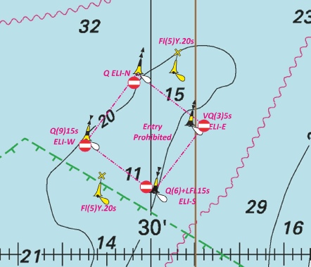
 SG 16
SG 16 
 SG 15
SG 15 
 Q ELI-
 VQ(3)5s ELI-
 Q(6)+LFl.15s ELI-
 Q(9)15s ELI-
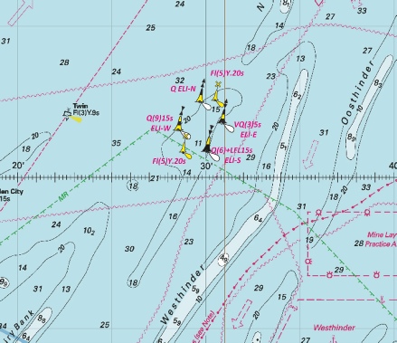
 Obstn
Obstn 


 Fl.Y.5s3M
 Fl.Y.5s3M, close NE of
 Fl.Y.2·5s3M, close NE of 52° 27´·72N., 1° 45´·82E.


 Iso.R.4s SG 6 at 51
 Iso.G.8s SG 5A
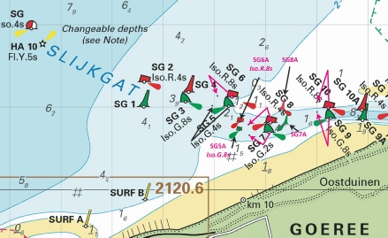

 VQ N Scroby


 with depth,
 Raysand North
  Raysand
  Raysand Middle
  Raysand North
 at 51° 23´·622N., 0° 30´·265E. and


 Obstn
Obstn 


 at 51° 22´·23N., 2° 29´·55E.


 at 51° 24´·42N., 2° 49´·09E.
 with
with  at 51° 22´·70N., 3° 05´·24E.
 ,
,  ,
, 

 at 51° 22´·16N., 2° 26´·23E.
 at 51° 22´·55N., 2° 29´·25E.
 at 51° 23´·47N., 2° 35´·90E.


 at 51° 11´·94N., 2° 44´·97E.
 at 51° 14´·78N., 2° 55´·39E.
 at 51° 24´·74N., 3° 06´·58E.


 at 51° 22´·72N., 3° 05´·20E.


 Fl(5)Y.20s


 at
at 


 Fl.Y.2s B
  Fl.Y.2s B at 52° 49´·09N., 0° 21´·14E.
 , and associated legend,

 at 51° 31´·92N., 1° 02´·86E.
 (3 buoys)

 at 51° 27´·496N., 0° 16´·031E.
 with
with  at 50° 48´·11N., 1° 19´·95E.


 Q Obstn23


 at 51° 35´·54N., 3° 07´·96E.
