|
Notices - |
||
|
Week 52 |
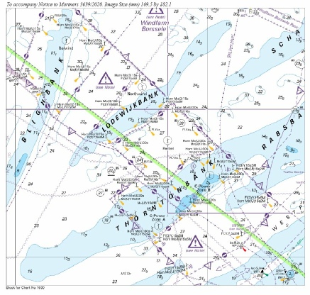
NETHERLANDS - Chart 110 Insert: submarine power cable, 51° 43´·60N., 2° 57´·95E. 51° 42´·04N., 3° 04´·06E. 51° 40´·23N., 3° 08´·72E. 51° 37´·06N., 3° 12´·56E. 51° 35´·98N., 3° 13´·30E. 51° 34´·79N., 3° 17´·26E. 51° 32´·15N., 3° 21´·58E. Chart 116 Insert:
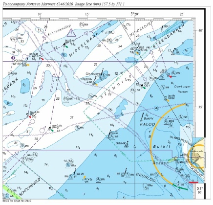
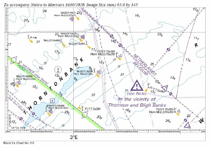
submarine power cable, 51° 32´·03N., 3° 21´·77E. 51° 28´·30N., 3° 29´·31E. 51° 25´·81N., 3° 32´·30E. 51° 25´·75N., 3° 32´·37E. 51° 25´·57N., 3° 36´·62E. 51° 25´·26N., 3° 41´·14E. Chart 1406 Insert: submarine power cable, 51° 25´·58N., 3° 43´·23E. 51° 25´·02N., 3° 42´·19E. 51° 25´·61N., 3° 32´·59E. 51° 28´·30N., 3° 29´·31E. 51° 34´·79N., 3° 16´·89E. 51° 35´·98N., 3° 13´·30E. 51° 40´·23N., 3° 08´·72E. 51° 42´·04N., 3° 04´·06E. 51° 43´·60N., 2° 57´·95E. Chart 1630 Insert: the accompanying block, centred on: 51° 37´·2N., 3° 11´·2E. submarine power cable, 51° 25´·53N., 3° 38´·40E. 51° 25´·72N., 3° 35´·91E. 51° 25´·61N., 3° 32´·59E. 51° 28´·29N., 3° 29´·31E. 51° 29´·73N., 3° 26´·34E. 51° 30´·75N., 3° 24´·68E. and 51° 25´·37N., 3° 38´·39E. 51° 25´·53N., 3° 32´·49E. 51° 28´·21N., 3° 29´·18E. 51° 29´·65N., 3° 26´·24E. 51° 30´·65N., 3° 24´·56E. Chart 2449 Insert: the accompanying block, centred on: 51° 35´·3N., 3° 17´·0E.
Images are copyright of the UKHO. |
Affects: UKHO Charts: 110, 116, 1406, 1630 and 2449 Imray Charts: C30. This notice has amendments for 4 charts covering Dutch waters east of Walcheren listing the submarine cables linking up the various Wind Farms north of Zeebrugge. The notice also provides two new UKHO blocks of that area.
|
|
Week 32 |
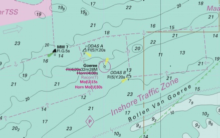
NETHERLANDS - Note: Radar beacon remains unchanged. Amend: light to, Mo(U)15s at 51° 55´·50N., 3° 40´·10E. fog signal to, Horn Mo(U)30s, at light above
Base image courtesy of Imray ID10 Chart C30 and Meridian Chartware |
Affects: UKHO Charts: 110, 112, 1406, 1408, 1630 and 2182A Imray Charts: C30 . Changes of the light and sound characteristics at the Goeree Light which is on the approaches to the Hook of Holland.
|
|
Week 30 |
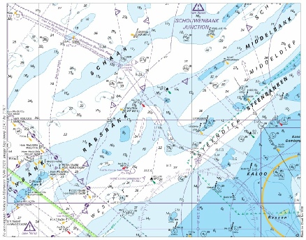
NETHERLANDS - Chart 110 Insert: the accompanying block, centred on: 51° 33´·8N., 3° 01´·4E. Chart 1630 Insert: the accompanying block, centred on: 51° 35´·4N., 2° 56´·0E.
Images copyright of the UKHO |
Affects: UKHO Charts: 110 and 1630 Imray Charts: C30 Two new UKHO blocks for two charts covering the Wind Farms adjacent to the Thorntonbank.
|
|
Week 26 |
New Editions of ADMIRALTY Charts 9th July, 2020 Chart 1872 - Blankenberge. 1:15,000 Chart 1874 - 1:60,000 A Zeebrugge. 1:20,000 B Brugge. 1:15,000 |
Includes significant safety- Includes significant safety- |
|
Week 16 |
NETHERLANDS - Insert: depth, 7.3 at 51° 25´·21N., 3° 06´·74E. Delete depth, 8, close S. Replace: depth, 13.5, with depth, 12.6 at 51° 27´·39N., 3° 01´·22E. Delete depth, 13, close NE.
Base image courtesy of Imray ID10 Chart C30 and Meridian Chartware |
Affects: UKHO Charts: 1630 and 2449 Imray Charts: C30 Two reductions of depth on the Flemish Banks off Zeebrugge.
|
|
Week 15 |
New Editions of ADMIRALTY Charts published 9th April 2020 Chart 1872 North Sea, Dunkerque to Vlissingen. 1:100,000 Blankenberge. 1:15,000 Note: On publication of this New Edition former Notices 1964(T)/18, 1749(P)/20 and 3524(T)/19 are cancelled. This chart remains affected by Notices 1745(P)/18, 242(T)/19, 428(P)/19, 1157(T)/19, 2320(T)/19, 2927(P)/19 and 6214(T)/19. Chart 1873 International Chart Series, North Sea, Dunkerque to Oostende. 1:60,000 A Oostende. 1:15,000 B Nieuwpoort. 1:20,000 Note: On publication of this New Edition former Notices 1964(T)/18 and 1749(P)/20 are cancelled. This chart remains affected by Notice 2320(T)/19. Chart 1874 International Chart Series, North Sea, Westerschelde, Oostende to Westkapelle. 1:60,000 A Zeebrugge. 1:20,000 B Brugge. 1:15,000 Note: On publication of this New Edition former Notices 3524(T)/19 and 1749(P)/20 are cancelled. This chart remains affected by Notices, 1745(P)/18, 242(T)/19, 428(P)/19, 1157(T)/19, 2927(P)/19 and 6214(T)/19. |
Includes significant safety- Includes significant safety- and buoyage. (A modified reproduction of INT1480 published by Belgium). Includes significant safety- (A modified reproduction of INT1474 published by Belgium). |
 joining:
 CAISSON