|
2023 Permanent/Temporary/Preliminary UKHO Notices to Mariners - |
||
|
Week 52 |
ENGLAND - Insert: depth, 6.1 at 51° 30´·494N., 0° 33´·368E. Delete depth, 6.4, close E. depth, 6.1 at 51° 30´·423N., 0° 33´·326E. Delete depth, 6.2, close NW. 8.2 at 51° 30´·411N., 0° 33´·417E. Delete depth, 8.7, close NE. 11.8 at 51° 30´·371N., 0° 33´·349E. Delete depth, 12.5, close E. depth, 12.3 at 51° 30´·329N., 0° 33´·354E. Delete depth, 14.4, close SE. Replace: depth, 3, with depth, 2.7 at 51° 30´·47N., 0° 33´·13E. depth, 14.3, with depth, 14.1 at 51° 30´·379N., 0° 33´·503E. Notice 4961 refers Base image courtesy of Imray ID10 Chart IN5036 and Meridian Chartware.
|
Affects: UKHO SNC: 1185 and 1186 (Panel A, Canvey Island to Coalhouse Point) UKHO SCC: 5606.8 Imray Full Charts: C2 Imray Leisure Folios: 2000.2 Seven reductions of depth in the River Thames off Hole Haven and the Tanker Jetties. Unlikely to hinder leisure craft.
|
|
Week 52 |
ENGLAND - Works are taking place at Berth 1, 52° 34´·516N., 1° 44´·031E. Construction of additional pontoon facilities are taking place in the vicinity of position 52° 34´·413N., 1° 44´·033E. Mariners are advised to navigate with caution in the area. Charts will be updated when works are complete. Notice 4979(P) refers Base image courtesy of Imray ID10 Chart C28C and Meridian Chartware.
|
Affects: UKHO SNC: 1534 UKHO SCC: 5614.4 and 5614.5 Imray Full Charts: C28C Works on Berth 1 in the River Yare and associated new pontoon works close by. The tide runs hard at that point.
|
|
Week 52 |
BELGIUM - Insert: depth, 19.5, extend 20m contour SW to enclose 51° 28´·83N., 2° 45´·27E. Delete depth, 20.5, close W and depth 20.3, close NW depth, 19.8, enclosed by 20m contour at 51° 26´·67N., 2° 46´·51E. Delete depth, 22, close S. depth, 13.8 at 51° 27´·49N., 2° 51´·64E. depth, 16.9 at 51° 29´·33N., 2° 57´·11E. Delete depth, 18.6, close W depth, 4.9, enclosed by 5m contour at 51° 25´·89N., 3° 04´·00E. Delete depth, 5.4, close S and depth 5.7 close N. depth, 12.3 at 51° 27´·10N., 2° 50´·33E. Delete depth, 14.3, close S. depth, 27.5 at 51° 31´·85N., 2° 44´·56E. Delete depth, 29, close NW. depth, 14.9 at 51° 27´·53N., 2° 53´·02E. Delete depth, 16.2, close W. Notice 5001 refers Base image courtesy of Imray ID10 Chart C30 and Meridian Chartware.
|
Affects: UKHO SNC: 1872, 1873, 1874 and 2449 UKHO SCC: 5606.8 Imray Full Charts: C30 8 reductions of depth in and around the Goote Bank offshore Zeebrugge. Unlikely to hinder leisure craft.
|
|
Week 52 |
ENGLAND - Insert depth, 11.8 at 51° 30´·20N., 0° 38´·23E. Delete depth, 12.4, close S. Notice 5014 refers Base image courtesy of Imray ID10 Chart IN5037 and Meridian Chartware.
|
Affects: UKHO SNC: 1185 UKHO SCC: 5606.8 Imray Full Charts: C2 Imray Leisure Folios: 2000.2 One reduction of depth right in the centre of the Yantlet Channel close to the recommended Small Craft Crossing transit twixt the West Leigh Middle and East Blyth buoys. At 11.8m it is unlikely to hinder any leisure craft but the Pilot of a Panamax might be concerned and a New Panamax v. worried!
|
|
Week 52 |
ENGLAND - Insert: depth, 8.7, and extend 10m contour S to enclose 51° 27´·399N., 0° 26´·384E. Delete depth, 11.4, close SE. Notice 5050 refers Base image courtesy of Imray ID10 Chart IN5036 and Meridian Chartware.
|
Affects: UKHO SNC: 1186 (Panel A, Canvey Island to Coalhouse Point) UKHO SCC: 5606.8 Imray Full Charts: C2 Imray Leisure Folios: 2000.3 One reduction of depth in the River Thames, Lower Hope Reach, close south of the Ovens SHB. Unlikely to hinder leisure craft.
|
|
Week 52 |
NETHERLANDS - Insert: depth, 4.9, enclosed by 5m contour at 51° 32´·39N., 3° 20´·00E. Delete depth 5.4. Notice 5048 refers Base image courtesy of Imray ID10 Chart C2120.4 and Meridian Chartware.
|
Affects: UKHO SNC: 110, 1630, 1872, 1874 and 2449 UKHO SCC: 5606.8 Imray Full Charts: C30 Imray Leisure Folios: 2120.4 One reduction of depth close east of the Botkil-
|
|
Week 51 |
ENGLAND - Insert :
Replace: depth, 11.9, with depth, 11.8 at 51° 41´·24N., 1° 17´·59E. Notice 4832 refers Base image courtesy of Imray ID10 Chart IN5043 and Meridian Chartware.
|
Affects: UKHO SNC: 1183 and 1975 UKHO SCC: 5606.6 and 5607.2 Imray Full Charts: C1 Imray Leisure Folios: 2000.1 One new wreck and one new depth in the Barrow Deep. Both will be unlikely to hinder any leisure craft but note that the wreck is in the corner of the Barrow Deep Anchorage!
|
|
Week 51 |
ENGLAND - Note: This update is included in New Edition 1828, published 21 December 2023. Insert: depth, 0.2 at 51° 19´·67N., 1° 25´·34E. Delete depth, 0.9, close W. Notice 4841 refers Base image courtesy of Imray ID10 Chart C8F and Meridian Chartware.
|
Affects: UKHO SNC: 1827 (Panel C, Ramsgate) (and 1828) UKHO SCC: 5605.15 (Panel B, Ramsgate and 5606.10 (Panel C, Ramsgate) Imray Full Charts: C8F Imray Leisure Folios: 2100.11B One new reduction of depth on the east side of entrance into the Ramsgate Royal Harbour. At 0.2m worth noting.
|
|
Week 51 |
BELGIUM - Amend: range of light to 22M at 51° 14´·179N., 2° 55´·829E. Notice 4828 refers Base image courtesy of Imray ID10 Chart C30C and Meridian Chartware.
|
Affects: UKHO SNC: 1406, 1872, 1873 (Panel A, Oostende), 1873, 1874, 2182A and 2449 UKHO SCC: 5605.12 (Panel E, Oostende), 5605.11, 5606.1 and 5607.1 Imray Full Charts: C30C Imray Leisure Folios: 2120.3 and 2120.4 The range of the Oostende Light House has been reduced from 27M to 22M.
|
|
Week 51 |
ENGLAND - Insert: depth, 8.1 at 51° 27´·857N., 0° 17´·754E. Delete depth, 8.2, close NE and depth, 8.2, close S. Notice 4880 refers Base image courtesy of Imray ID10 Chart IN5036 and Meridian Chartware.
|
Affects: UKHO SNC: 2151 UKHO SCC: 5665.14 (Panel A, Gravesend Reach to Erith Reach. Imray Full Charts: C2 Imray Leisure Folios: 2100.3 (Panel B Queen Elizabeth Bridge to Coalhouse Point). One small, very small reduction of depth on the edge of the main channel of the River Thames at Fiddler’s Reach (West Thurrock). Unlikely to hinder leisure craft.
|
|
Week 51 |
ENGLAND - Insert: drying height, 0.1, enclosed by 0m low water line at 52° 28´·18N., 1° 45´·53E. Delete depth, 1.6, close N. Notice 4888 refers Base image courtesy of Imray ID10 Chart C28D and Meridian Chartware.
|
Affects: UKHO SNC: 1535 UKHO SCC: 5614.3 Imray Full Charts: C28D One reduction of depth on the west side of the Newcome Sand approaching Lowestoft. Worth noting if using the Lowestoft South Road.
|
|
Week 50 |
Admiralty Charts To Be Published 28 December 2023 New Editions of ADMIRALTY SN Charts Chart 2052 - Chart 2693 - A Continuation of River Stour. 1:25,000 B Ipswich. 1:10,000 C Continuation of River Deben. 1:25,000 |
Includes changes to depths from the latest British Government and Port Authority Surveys, amended dredged areas and navigational aids. Includes significant safety- |
|
Week 50 |
ENGLAND - Replace:
Notice 4681 refers Base image courtesy of Imray ID10 Chart C28 and Meridian Chartware.
|
Affects: UKHO SNC: 1535 UKHO SCC: 5614.3 Imray Full Charts: C28 This notice is only updating the Small Craft Chart covering the Holm Sand (north of Lowestoft probably because the last edition of the relevant SNC (SNC 1535) included the change. The change is replace the wreck icon and depth 4.7m with just the depth of 1.7m. From which we can conclude that the wreck has been covered by sand. There were a number of revised depths around the Holm Sand vide NtM 956 so I have used the same image but updated it.
|
|
Week 50 |
ENGLAND - The yellow light- 52° 55´·70N., 0° 16´·52E. is reported off station until further notice. Mariners are advised to navigate with caution in the area. Notice 4710(T) refers Base image courtesy of Imray ID10 Chart Y9 and Meridian Chartware.
|
NOTICE: Kings Lynn Conservatory Board have just announced the W1 buoy and AIS has been put back into place. 04/12/23 Affects: UKHO SNC: 108 and 1200 UKHO SCC: 5614.11 and 5614.9 Imray Full Charts: Y9 The yellow light buoy W1 marking the shipping Wisbech and Sutton Bridge anchorage in the Wash is temporarily reported off station.
|
|
Week 50 |
ENGLAND - A dangerous wreck exists in approximate position 52° 35´·000N., 1° 43´·800E. Mariners are advised to navigate with caution in the area and consult the local port authorities for the latest information. Notice 4713(T) refers Base image courtesy of Imray ID10 Chart C28C and Meridian Chartware.
|
Affects: UKHO SNC: 1534 UKHO SCC: 5614.4 and 5614.5 Imray Full Charts: C28C A dangerous wreck is reported in the River Yare close to the west side of the bank, just above the tunnel.
|
|
Week 49 |
Admiralty Charts To Be Published 21 December 2023 New Editions of ADMIRALTY SN Charts Chart 1828 - |
New Edition to include latest information from British Government Surveys. |
|
Week 49 |
ENGLAND - Insert: drying height, 2.1 at 51° 23´·899N., 0° 31´·394E. Delete drying height, 1.6, close SW. Notice 4555 refers Base image courtesy of Imray ID10 Chart Y18 and Meridian Chartware.
|
Affects: UKHO SNC: 1835 UKHO SCC: 5606.11 Imray Full Charts: Y18 Imray Leisure Folios: 2100.5 One new drying height close by the south side of Whitewall Creek in Upnor Reach, River Medway.
|
|
Week 49 |
ENGLAND - Insert: depth, 13.9 at 51° 30´·164N., 0° 30´·915E. Delete depth, 14, close W. Notice 4579 refers Base image courtesy of Imray ID10 Chart C2 and Meridian Chartware.
|
Affects: UKHO SNC: 1186 (Panel A, Convey Island to Coalhouse Point) UKHO SCC: 5605.14, 5606.5 and 5606.2. Imray Full Charts: C2 Imray Leisure Charts: 2100.2 This a matter of precision: one (tiny) reduction of depth on the northern edge of the Yantlet Channel opposite Cliffe Fleet in the River Thames. Very unlikely to hinder leisure craft.
|
|
Week 49 |
FRANCE - Insert: circular limit of restricted area, radius 300m, entry prohibited, pecked line, centred on: 51° 16´·17N., 2° 17´·04E. Notice 4613 refers Base image courtesy of Imray ID10 Chart C30 and Meridian Chartware.
|
Affects: UKHO SNC: 323 and 1873 UKHO SCC: 5605.11 Imray Full Charts: C30 A restricted area of 300m radius has been imposed on the Separation Zone just at the entrance of the West Hinder TSS. This is SW of the Bergues north cardinal buoy. Note that NtM 424(T) earlier this year there was a Virtual AIS waypoint.
|
|
Week 48 |
East Coast Of England - Caister Road - Moved to new assigned position: Latitude 52° 40.760’N., Longitude 001° 45.800’E. North Scroby Lighted Buoy Moved to new assigned position: Latitude 52° 41.560’N., Longitude 001° 46.530’E. Movement effected consequent upon a recent survey. Trinity House Notices to Mariners No 30 of 2023 refers Base image courtesy of Imray ID10 Chart C28 and Meridian Chartware.
|
Affects: UKHO SNC: 1534 and 1543. UKHO SCC: 5614. 5 (Panel A, Northern Approaches to Great Yarmouth). Imray Full Charts: C28 Trinity House have moved the North Caister North Cardinal Buoy to the north. There have been several UKHO Notices this year advising changed depth in and around the North Scroby sands.
|
|
Week 48 |
BELGIUM - Delete:
Move:
Notice 4434 refers Base image courtesy of Imray ID10 Chart C2120.4 and Meridian Chartware.
|
Affects: UKHO SNC: 1872, 1873, 1874 (Panel C, Zeebrugge Voorhaven) and 2449 UKHO SCC: 5605.11 Imray Full Charts: C30 Imray Leisure Folios: C2120.4 Two different areas: first, three buoys marking (with others) a major wreck on the south side of the Nieuwpoort Bank have been removed. Ample other marks are retained. Second there is a very small move of the ‘Z2’ port hand buoy within the harbour of Zeebrugge.
|
|
Week 47 |
BELGIUM - Chart 1872 Insert the accompanying block, centred on: 51° 14´·4N., 2° 35´·8E. Chart 2449 Insert the accompanying block, centred on: 51° 16´·4N., 2° 44´·4E. All Charts Insert: legend, Historic Wk (see Note), at wreck 51° 26´·80N., 2° 20´·00E. 51° 17´·43N., 2° 36´·39E. 51° 21´·19N., 2° 38´·33E. 51° 19´·71N., 2° 49´·30E. 51° 33´·14N., 2° 51´·65E. 51° 18´·79N., 2° 56´·75E. 51° 12´·52N., 2° 38´·63E. 51° 25´·67N., 3° 07´·31E. legend, Historic Wks (see Note), at wreck 51° 13´·88N., 2° 38´·03E. 51° 13´·88N., 2° 38´·03E. 51° 27´·40N., 3° 04´·32E. 51° 27´·35N., 3° 03´·98E. 51° 25´·46N., 3° 05´·43E. radar beacon, Racon(N), at light MOW4 at 51° 25´·10N., 3° 17´·92E.
legend, Historic Wk (see note), close W. Replace:
legend, Historic Wk (see note), close SE. Notice 4309 refers UKHO Blocks are UKHO copyright.
|
Affects: UKHO SNC: 1406, 1610, 1873, 1874 and 2449 UKHO SCC: 5605.11, 5605.1 (Panel B, Northern Approaches to Dover Strait), 5606.1 and 5607.1. Imray Full Charts: C30 Imray Leisure Charts: 2120.1, 2120.3 and 2120.4. This Notices is probably the most involved (but not particularly complicated) Notice in over the ten years that I have illustrated. The Notice is derived from two Belgium notices and has a variety of different corrections. The notice affects 5 UKHO SNC and 4 UKHO SCC, one full Imray chart and 3 Imray Leisure Charts. The Notice provides a UKHO block each for 2 of the 5 SNC and has 18 additional corrections. The corrections comprise: 8 wrecks which are now designated ‘Historic Wk’ 4 locations with wrecks that are now designated ‘Historic Wks’ 1 existing light now had Racon: this is the light MOW4 which is north of the Wielingen Channel twixt Oostende and Vlissingen 5 existing wrecks with revised depths and designation of ‘Historic Wk’ . Apart from the Racon on light MOW4, the changes are unlikely to hinder, or be hindered by, or much relevant to leisure craft.
|
|
Week 47 |
ENGLAND - Amend: legend to, Dredged to 16·0m, centred on: 51° 55´·91N., 1° 25´·29E. legend to, 16·0m, centred on: 51° 53´·09N., 1° 33´·61E. Insert limit of dredged channel, pecked line, joining: 51° 52´·37N., 1° 33´·16E. 51° 52´·24N., 1° 33´·20E. Delete former limit of dredged channel, pecked line, joining: 51° 52´·37N., 1° 33´·16E. 51° 52´·24N., 1° 33´·14E. legend, Channel Deepening (see Note), centred on: 51° 56´·36N., 1° 31´·25E. 51° 52´·93N., 1° 33´·60E. Notice 4352 refers Base image courtesy of Imray ID10 Chart C1 and Meridian Chartware.
|
Affects: UKHO SNC: 1183, 1610 and 2692 UKHO SCC: 5607.2. Imray Full Charts: C1 and Y16 This notice changes the depth of the dredged channel from the Sunk to and into Felixstowe to an increased 16m and extends the marked channel to extend south right up to the S. Threshold yellow special lit buoy.
|
|
Week 46 |
New Editions of ADMIRALTY Small Craft Charts to be published on 30th November, 2023 SCC 5606.4 Gull Stream to Princes Channel. 1:50,000 SCC 5606.5 Princes Channel to Medway Approach Channel. 1:50,000 SCC 5606.6 Whitaker Channel to West Swin. 1:50,000 |
Includes full updates for New Edition and Notices to Mariners affecting source charts. |
|
Week 45 |
New Editions of ADMIRALTY Small Craft Charts to be published on 23rd November, 2023 SCC 5606.10 A Mouth of River Medway and West Swale. 1:25,000 B The Swale, Ferry Reach. 1:12,500 C Ramsgate. 1:5,000 SCC 5606.11 A River Medway, Saltpan Reach to Chatham Reach. 1:25,000 B River Medway, Rochester. 1:12,500 C Approaches to Ramsgate. 1:12,500 SCC 5606.12 A The Swale, Shell Ness to Conyer Creek. 1:25,000 B River Medway, Rochester Bridge to Wouldham. 1:25,000 C River Medway,Wouldham to Lower Cut. 1:25,000 D Lower Cut to Allington Marina. 1:25,000 E Continuation to Maidstone. 1:25,000 |
Includes full updates for New Edition and Notices to Mariners affecting source charts. |
|
Week 45 |
ENGLAND - Insert: depth, 2.9, enclosed by 5m approximate contour 52° 36´·55N., 1° 46´·52E. Notice 4095 refers Base image courtesy of Imray ID10 Chart C28 and Meridian Chartware.
|
Affects: UKHO SNC: 1534 UKHO SCC: 5614.5 (Panel A, Northern Approaches to Great Yarmouth) Imray Full Charts: C28 This notice is identical to NtM 3902 last week. Its purpose is to notify the correction to the appropriate Small Craft Chart (5614.5 Panel A).
|
|
Week 44 |
ENGLAND - Insert: depth, 2.9, enclosed by 5m approximate contour 52° 36´·55N., 1° 46´·52E. Notice 3902 refers Base image courtesy of Imray ID10 Chart C28 and Meridian Chartware.
|
Affects: UKHO SNC: 1534 UKHO SCC: 5614.5 (Panel A, Northern Approaches to Great Yarmouth) Imray Full Charts: C28 One reduction of depth just east of the Scroby Elbow SHB. In week 37 (NtM 3088) we had a series of reductions of depth along the west edge of the South Scroby sands so this reduction is added (in blue) to the previous image.
|
|
Week 44 |
ENGLAND - Insert: depth, 3.2 at 51° 30´·330N., 0° 00´·302E. Delete depth, 3.5, close N. depth, 5.1 at 51° 30´·178N., 0° 00´·656E. depth, 1.7, and extend 2m contour SE to enclose 51° 30´·152N., 0° 00´·544E. Replace: depth, 2.3, with depth, 1.5, and extend 2m contour N to enclose 51° 30´·125N., 0° 00´·575E. Notice 3926 refers Base image courtesy of Imray ID10 Chart IN5030 and Meridian Chartware.
|
Affects: UKHO SNC: 3337 UKHO SCC: 5606.15 Imray Full Charts: C2 Imray Leisure Charts: 2100.4 4 reductions of depth in the River Thames, one in the centre of Bugsby Reach, a second on the edge of the channel of the Reach and two soundings off North Greenwich Pier.
|
|
Week 43 |
ENGLAND - Insert: depth, 9.6, enclosed by 10m contour at 52° 38´·87N., 1° 49´·13E. depth, 1.8, enclosed by 2m contour at 52° 37´·99N., 1° 49´·13E. Delete depth, 12.7, close N. depth, 0.7, enclosed by 2m contour at 52° 38´·06N., 1° 48´·80E. Delete depth, 10.8, close N. Notice 3842 refers Base image courtesy of Imray ID10 Charts C28 and Meridian Chartware.
|
Affects: UKHO SNC: 1534 and 1543 UKHO SCC: 5614.2 and 5614.6 (Panel A, Caister- Imray Full Charts: C28 Three dramatic reductions of depth e.g. from 10.8m to 0.7m, on the east side of the Middle Scroby Sands. The east side of the Scoby Sands i.e abutting Barley Picle is not marked by buoyage.
|
|
Week 42 |
ENGLAND - Insert: limit of restricted area 51° 26´·081N., 0° 40´·406E. 51° 25´·659N., 0° 39´·227E. 51° 25´·057N., 0° 38´·426E. and 51° 25´·053N., 0° 38´·420E. 51° 24´·970N., 0° 38´·310E. 51° 24´·881N., 0° 36´·326E. and 51° 24´·879N., 0° 36´·320E. 51° 24´·872N., 0° 36´·302E. and 51° 24´·866N., 0° 36´·287E. 51° 24´·600N., 0° 35´·636E. 51° 24´·115N., 0° 35´·005E. 51° 24´·067N., 0° 34´·452E. and 51° 24´·742N., 0° 33´·039E. 51° 24´·566N., 0° 33´·039E. 51° 24´·006N., 0° 33´·755E. 51° 24´·115N., 0° 35´·005E. 51° 24´·147N., 0° 35´·048E. Notice 3711 refers Base image courtesy of Imray ID10 Charts Y18 and Meridian Chartware.
|
Affects: UKHO SNC: 1834 and 1835 (This update is included in New Edition 2482, published 7 September 2023) UKHO SCC: 5606.11 (Panel A, Saltpan Reach to Chatham) Imray Full Charts: Y18 Imray Leisure Charts: 2100.5 A new limit prohibiting fishing in the River Medway. The Limit extends west from Elphinstone Point to the starboard hand buoy off Stoke Creek to Oakham Ness Jetty to Oakham Ness to the RoRo at Kingsnorth Jetty to No 23 Darnet SHB to the North Cardinal Beacon at Folly Point to a point midway south of Hoo Island to No 29 SHB to No 31 PHB to land west of Port Werburgh.
|
|
Week 42 |
ENGLAND - Replace: symbol, black unlit beacon with sphere topmark, Yantlet Beacon, with Notice 3746 refers Base image courtesy of Imray ID10 Charts IN5037 and Meridian Chartware.
|
Affects: UKHO SNC: 1185 UKHO SCC: 5606.8 Imray Full Charts: C2 Imray Leisure Charts: 2100.2 The Yantlet Beacon which used to mark the entrance of the Yantlet Creek at Allhallows Marsh on the north side of the Isle of Grain has gone leaving an obstruction.
|
|
Week 42 |
ENGLAND - Insert: depth, 7.9 at 51° 29´·33N., 1° 09´·19E. Notice 3764 refers Base image courtesy of Imray ID10 Charts IN5043 and Meridian Chartware.
|
Affects: UKHO SNC: 1606, 1607 and 1609 UKHO SCC: 5606.2 Imray Full Charts: Y16 Imray Leisure Charts: 2100.1 One reduction of depth right in the middle of the Princes Channel north of the Princes Mid yellow special lit buoy. Not where you need to be and unlikely to hinder leisure craft.
|
|
Week 41 |
ENGLAND - Insert: depth, 7.4 at 52° 08´·48N., 1° 38´·19E. Delete depth, 8.4 and 8.6, close NE. depth, 0.9, and extend 2m approximate contour SE to enclose 52° 06´·84N., 1° 36´·83E. Notice 3585 refers Base image courtesy of Imray ID10 Charts C28 and Meridian Chartware.
|
Affects: UKHO SNC: 1504, 1543, 1610 UKHO SCC: 5614.1 (Panel A, Orford Ness to Benacre Ness) Imray Full Charts: C28 Two reductions of depth on the Aldeburgh Ridge marking reductions slightly to the east and north east parts of the sands.
|
|
Week 41 |
ENGLAND - Insert: depth, 4.3, and extend 5m contour NW to enclose 52° 28´·257N., 1° 45´·552E. Delete depth, 6.1, close SW and depth, 5.9, close NE. depth, 1.6, and extend 2m contour N to enclose 52° 28´·21N., 1° 45´·53E. Delete depth, 1.2, close S. Notice 3589 refers Base image courtesy of Imray ID10 Chart C28D and Meridian Chartware.
|
Affects: UKHO SNC: 1535 (Panel Lowestoft Harbour) and 1535 UKHO SCC: 5614.2 and 5614.3 Imray Full Charts: C28D One reduction of depth and unusually one increase of depth (to 1.6m) at the entrance of Lowestoft Harbour.
|
|
Week 41 |
ENGLAND - Works to deepen the Harwich Deep Water Channel to 16·0m have been completed. There have also been changes to the limits of Harwich Deep Water Channel. The most significant changes are as follows: New Position Former Position 51° 52´·24N., 1° 33´·20E. 51° 52´·24N., 1° 33´·14E. 51° 55´·413N., 1° 18´·954E. 51° 55´·397N., 1° 18´·937E. 51° 55´·720N., 1° 18´·560E. 51° 55´·715N., 1° 18´·538E. Mariners are advised to navigate with caution in the area. WGS84 DATUM) Notice 3598(P) refers
|
Affects: UKHO SNC: 1183, 1491, 1610, 2052, 2692 and 2693 UKHO SCC: 5607.2, 5607.4, 5607.5 and 5607.6 Imray Full Charts: Y16 Imray Leisure Charts: 2000.1 and 2000.4 For the latest information consult Harwich Harbour Operations Service (or Harwich VTS) and local notices. These changes will be included in the next New Edition of Charts 1491, 2693, 2052, 5607.4, 5607.5, 5607.6, to be published late 2023. Chart 1183, 1610, 2692 and 5607.2 will be updated by Notice to Mariners. This notice amends the limits of the Harwich Deep Water channel following the substantial project deepening the channel to 16m. There are three limits quoted as the most significant changes but (unusually) I am not illustrating the changes as they are so small. |
|
Week 41 |
NETHERLANDS - Insert: the accompanying block, centred on: 51° 53´·5N., 4° 06´·0E.
limit of marine farm, pecked line, joining above
Delete: depth, 19.9 at 51° 36´·36N., 3° 36´·50E. Notice 3637 refers Base image courtesy of Imray ID10 Chart C2120.6 and Meridian Chartware
|
Affects: UKHO SNC: 110 and 116 Imray Full Charts: C30 Imray Leisure Charts: 2120.6 A new marine farm on the north side of the Roompot, to the Oosterschelde, Holland: includes one deletion of depth in the middle of the farm. A new margin note is added by a UKHO block.
|
|
Week 41 |
ENGLAND - Insert: limit of dredged area, pecked line, joining: 51° 56´·870N., 1° 15´·501E. 51° 56´·894N., 1° 15´·504E. dredged depth, 8·5m, centred on: 51° 56´·879N., 1° 15´·566E. Delete: former limit of dredged area, pecked line, and associated legend, 9·5m, joining: 51° 56´·875N., 1° 15´·386E. 51° 56´·900N., 1° 15´·389E. 51° 56´·894N., 1° 15´·504E. Notice 3672 refers Base image courtesy of Imray ID10 Chart Y16 and Meridian Chartware.
|
Affects: UKHO SNC: 1491 and 2693 UKHO SCC: 5607.7 (Panel A, River Stour) Imray Full Charts: Y16 Imray Leisure Charts: 2000.4 and 2000.5 This is small detail: a revised limit of the dredged area at the Parkeston Quay RoRo on the River Stour (at Harwich).
|
|
Week 41 |
ENGLAND - Replace:
Notice 3676 refers Base image courtesy of Imray ID10 Chart IN5037 and Meridian Chartware.
|
Affects: UKHO SNC: 3683 UKHO SCC: 5606.9 Imray Full Charts: C1 Imray Leisure Charts: 2100.4 Depth over an established wreck in the Medway Approach Channel is reduced to 17.9m. Unlikely to hinder leisure craft as we shouldn’t be there and has enough water!
|
|
Week 41 |
ENGLAND - Insert depth, 2.9 at 51° 29´·830N., 0° 01´·648E. Delete depth, 3.4, close NW and depth, 3.1 at 51° 29´·837N., 0° 01´·702E. depth, 5.7 at 51° 29´·733N., 0° 01´·648E. Delete depth, 5.8, close NE. Replace: depth, 2.8, with depth, 4.4 at 51° 29´·747N., 0° 02´·521E. Notice 3678 refers Base image courtesy of Imray ID10 Chart IN5030 and Meridian Chartware.
|
Affects: UKHO SNC: 3337 (Panel B, Thames Tidal Barrier) and 3337 Imray Full Charts: C2 Imray Leisure Charts: 2100.3 Two reductions of depth west of the Thames Barrier and an increase of depth at the Barrier Garden Pier east of the Thames Barrier.
|
|
Week 40 |
BELGIUM - Delete:
Notice 3509 refers Base image courtesy of Imray ID10 Charts C2120.430 and Meridian Chartware.
|
Affects: UKHO SNC: 1872 and 1874 Imray Full Charts: C30 Imray Leisure Charts: 2120.4 Two special yellow buoys west of Cadzand very close, close to the shore are deleted. One buoy is designated ‘HD17’ (the other not illustrated)
|
|
Week 40 |
FRANCE - Insert:
Move:
Notice 3541 refers Base image courtesy of Imray ID10 Charts C2110.2 and Meridian Chartware.
|
Affects: UKHO SNC: 323, 1350 and 1873 UKHO SCC: 5605.12 (Panel C, Dunkerque) and 5605.10. Imray Full Charts: C30 Imray Leisure Charts: 2110.2 Two new Yellow Special ODAS buoys close south of the Banc in Ratel (off Dunkerque) and four small moves of channel markers in the Chenal Intermediaire between the west and east entrances of Dunkerque.
|
|
Week 39 |
New Editions of ADMIRALTY Small Craft Charts to be published on 12th October, 2023 SCC 5614.3 Approaches to Lowestoft. 1:25,000 SCC 5614.4 A Approaches to Great Yarmouth. 1:25,000 B Great Yarmouth Outer Harbour. 1:7,500 SCC 5614.5 A Northern Approaches to Great Yarmouth. 1:25,000 B Great Yarmouth Haven. 1:7,500 SCC 5614.20 Whitton Ness to Goole and Keadby and Lowestoft Harbour. A Lowestoft Harbour. 1:6,250 B Whitton Ness to Goole and Mere Dyke. 1:50,000 C Continuation to Keadby. 1:50,000 |
Includes full updates for New Edition and Notices to Mariners affecting source charts. |
|
Week 39 |
BELGIUM - Yellow light- Type Characteristics Designation AIS Position Superbuoy ODAS Fl(5)Y.20s SWLB068 Yes 51° 28´·14N., 2° 25´·77E. Conical ODAS Fl(5)Y.20s SWMini073 No 51° 31´·13N., 2° 29´·28E. Superbuoy ODAS Fl(5)Y.20s SWLB069 Yes 51° 35´·41N., 2° 32´·12E. Mariners are advised to navigate with caution. Notice 3314(T) refers Base image courtesy of Imray ID10 Charts C30 and Meridian Chartware.
|
Affects: UKHO SNC: 1406, 1872 and 2449 UKHO SCC: 5606.1 and 5607.1 Imray Full Charts: C30 Three temporary ODAS buoys ( Ocean data acquisition system), two superbuoy size have been positioned west of the Westhinder and Noordhinder banks east of the TSS.
|
|
Week 39 |
ENGLAND - Amend: legend to, 5·6m, centred on: 52° 02´·331N., 1° 09´·437E. legend to, 8·2m, centred on: 52° 02´·342N., 1° 09´·530E. legend to, 6·2m, centred on: 52° 02´·459N., 1° 09´·449E. legend to, 8·4m, centred on: 52° 02´·561N., 1° 09´·681E. legend to, 7·2m, centred on: 52° 02´·603N., 1° 09´·710E. Notice 3355 refers Base image courtesy of Imray ID10 Charts Y16A and Meridian Chartware.
|
Affects: UKHO SNC: 2693 (Panel B Ipswich) UKHO SCC: 5607.7 (Panel C, Ipswich) Imray Full Charts: Y16A Imray Leisure Charts: 2000.5A 5 revised depths alongside the berths at Ipswich Quays.
|
|
Week 39 |
ENGLAND - Works are taking place in the Wellington Docks (51° 07´·21N., 1° 18´·66E.) Pontoons have been removed leaving the unlit support piles. Mariners are advised to navigate with caution in the area and consult the local port authorities for the latest information. Notice 3366(T) refers
|
Affects: UKHO SNC: 1698 UKHO SCC: 5605.14 Imray Full Charts: C8 Imray Leisure Charts: 2100.11C Works inside Wellington Docks in Dover Harbour is taking place. Pontoons have been removed leaving unlit piles in place. No image. |
|
Week 38 |
New Editions of ADMIRALTY Small Craft Charts to be published on 5th October, 2023 SCC 5607.3 Outer Approaches to the River Blackwater 1:50,000 SCC 5607.4 Southern Approaches to Harwich 1:50,000 |
Includes full updates for New Edition and Notices to Mariners affecting source charts. |
|
Week 38 |
BELGIUM - A North cardinal light- Former Notice 427(T)/23 is cancelled. Notice 3183(T) refers Base image courtesy of Imray ID10 Charts DELCST100 and Meridian Chartware.
|
Affects: UKHO SNC: 1872, 1873, 1874 and 2449 UKHO SCC: 5605.11 Imray Full Charts: C30 Imray Leisure Charts: 2120.4 The new north cardinal buoy placed west of the Oostende harbour (guarding two old wrecks) vide NtM 427(T) earlier this year is now moved slightly more to the west and towards the shore.
|
|
Week 38 |
ENGLAND - Insert: depth, 9.7, and extend 10m contour W to enclose 52° 27´·76N., 1° 46´·89E. Delete depth, 10.2, close S. depth, 4.8, and extend 5m contour W to enclose 52° 26´·68N., 1° 47´·19E. depth, 4.3, and extend 5m contour N to enclose 52° 26´·48N., 1° 47´·14E. Delete depth, 5.1, close NW and depth, 5.3, close SW. depth, 2.5 at 52° 26´·37N., 1° 46´·96E. Delete depth, 3.4, close E. depth, 2.6 at 52° 26´·26N., 1° 46´·88E. Delete depth, 3.6, close SW. Replace: depth, 4.7, with depth, 4.3 at 52° 26´·57N., 1° 47´·18E. Notice 3232 refers Base image courtesy of Imray ID10 Charts C28 and Meridian Chartware.
|
Affects: UKHO SNC: 1535 and 1543 UKHO SCC: 5614.3, 5614.1 (Panel A, Orford Ness to Benacre Ness) and 5614.2 Imray Full Charts: C28 Five reductions of depth, one just south of the SW Holm SHB and 4 between the South Holm cardinal buoy and Newcombe Sand PHB. Unlikely to hinder leisure craft but the trend of the south entrance of the Stanford Channel is to shallow.
|
|
Week 38 |
FRANCE - Insert: the accompanying block, centred on: 50° 58´·8N., 1° 51´·7E. Notice 3214 refers The block is copyright of the UKHO.
|
Affects: UKHO SNC: 1351 UKHO SCC: 5605.12A Imray Full Charts: C8G Imray Leisure Charts:2100.11D A new UKHO block showing the outer commercial basin of Calais harbour.
|
|
Week 38 |
FRANCE - Insert: depth, 5, and extend 5m contour SW to enclose 51° 08´·60N., 2° 21´·90E. Delete depth, 5.5, close NW. depth, 1.9, enclosed by 2m and 5m contours and extend 10m contour SE to enclose 51° 09´·39N., 2° 23´·95E. Notice 3238 refers Base image courtesy of Imray ID10 Charts C30 and Meridian Chartware.
|
Affects: UKHO SNC: 323 and 2449 UKHO SCC: 5605.10 and 5605.11 Imray Full Charts: C30 Two reduction of depth on the Binnen Ratel bank (one of the banks off Dunkerque). Now quite shallow and not marked. Note on the image the ODAS superbuoy is deleted as notified in an earlier NtM.
|
|
Week 38 |
NETHERLANDS - Sector light, Oc.WRG.6s11m6M, in position 51° 31´·59N., 3° 26´·05E., has been temporarily extinguished. Mariners are advised to navigate with caution in the area and consult the local port authorities for the latest information. Notice 3247(T) refers Base image courtesy of Imray ID10 Charts C28 and Meridian Chartware.
|
Affects: UKHO SNC: 116, 1872 and 1874 Imray Full Charts: C30 Imray Leisure Charts: 2120.4 The sector light at the Oostgat point (on the Dutch Walcheren coast by Westkepelle) is temporarily extinguished.
|
|
Week 37 |
ENGLAND - Insert: depth, 10.1 at 52° 34´·628N., 1° 44´·778E. Delete depth, 10.7, close N. depth, 5.4 at 52° 34´·349N., 1° 44´·299E. Delete depth, 5.8, close W. depth, 9.3, enclosed by 10m approximate contour at 52° 37´·21N., 1° 46´·47E. Delete depth, 13.4, close N and depth, 13.7, close W. depth, 2.8, enclosed by 5m approximate contour at 52° 37´·03N., 1° 46´·51E. Delete depth, 11.4, close NE. depth, 4.3, enclosed by 5m approximate contour at 52° 36´·84N., 1° 46´·51E. Delete depth, 11, close NE and depth, 11.7, close NE depth, 6, enclosed by 10m approximate contour at 52° 36´·66N., 1° 46´·50E. Delete depth, 11.3, close E. depth, 3.1, enclosed by 5m approximate contour at 52° 36´·48N., 1° 46´·59E. Delete depth, 11.1, close SW. depth, 1.3 at 52° 34´·280N., 1° 44´·243E. Delete depth, 1.8, close SW. depth, 6.3, and extend 10m contour W to enclose 52° 36´·01N., 1° 46´·65E. Notice 3088 refers Base image courtesy of Imray ID10 Charts C28 and Meridian Chartware.
|
Affects: UKHO SNC: 1534 (Panel A, Great Yarmouth Outer Harbour), 1534 and 1543 UKHO SCC: 5614.4 (Panel B, Great Yarmouth Outer Harbour), 5614.4 (Panel A, Approaches to Great Yarmouth). 5614.5 (Panel A, Northern Approaches to Great Yarmouth) and 5614.2 Imray Full Charts: C28 and C28C Three new depths around the entrance to both the Outer Harbour of Great Yarmouth and the Yare entrance plus 6 seriously reduced depths on the west side of the South Scoby Sands. There are two earlier NtMs around the Outer Harbour; these depths are included in the first image in blue.
|
|
Week 37 |
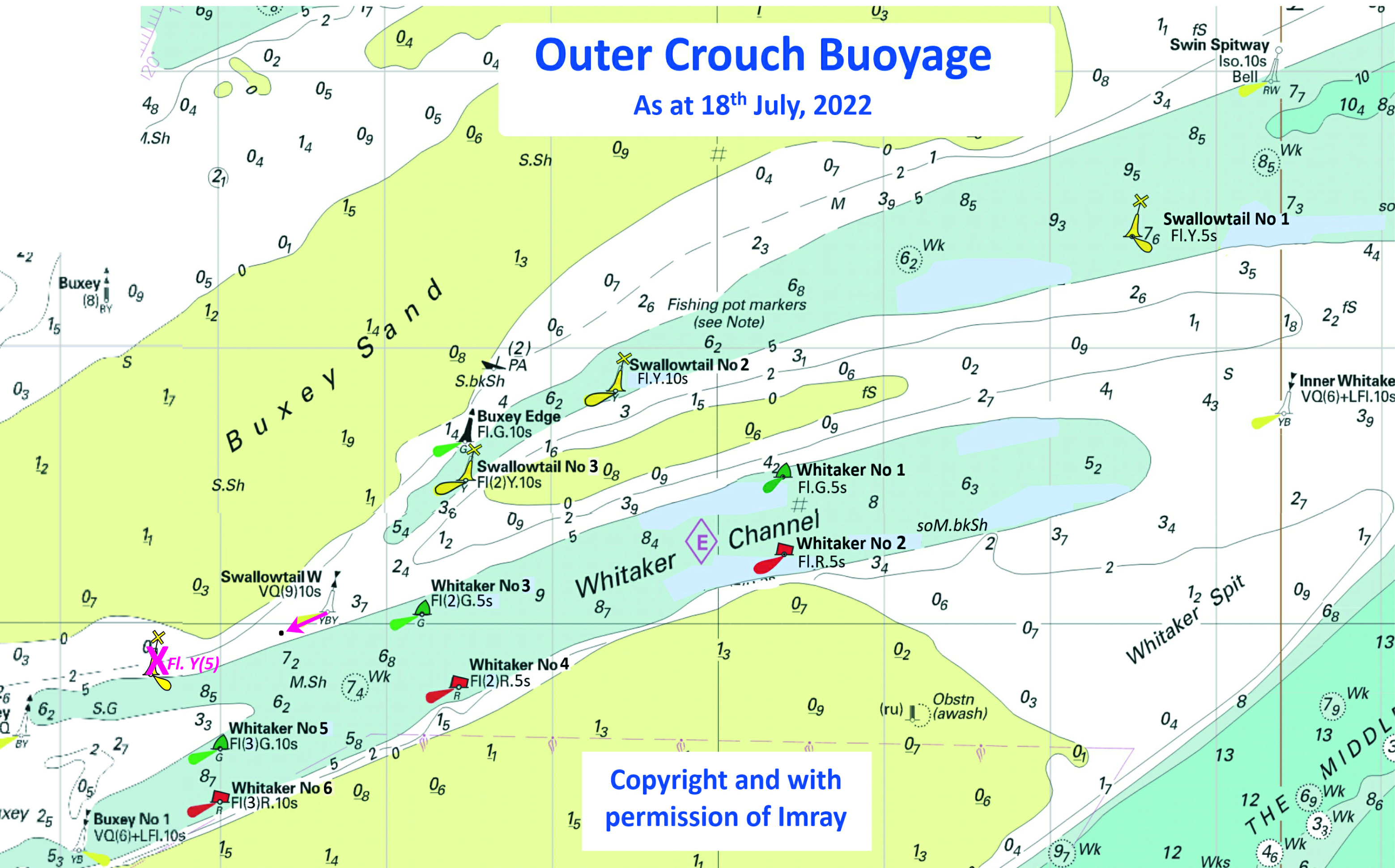
ENGLAND - The following light- Characteristic Designation Position Fl.Y.10s Swallowtail No 2 51° 40´·84N., 1° 04´·39E. Fl(2)Y.10s Swallowtail No 3 51° 40´·52N., 1° 03´·45E. Mariners are advised to navigate with caution in the area. Notice 3095(T) refers Base image courtesy of Imray ID10 Charts Y17 and Meridian Chartware.
|
Affects: UKHO SNC: 1975 and 3750 UKHO SCC: 5606.6 and 5607.3 Imray Full Charts: Y17B Imray Leisure Charts: 2000.8 The Yellow special Swallowtail buoys Nos 2 and 3 are temporary absent for maintenance. They were removed in June but Crouch HA have not yet announced their return.
|
|
Week 37 |
ENGLAND - Replace: the existing note, CROSS CHANNEL FERRIES, with the accompanying note, CROSS- Chart 323: 50° 57´·60N., 2° 10´·41E. Chart 1610: 51° 08´·40N., 1° 02´·26E. Chart 1698: 51° 07´·548N., 1° 17´·672E. Chart 1828: 51° 11´·67N., 1° 19´·21E. Chart 1892: 50° 44´·75N., 1° 52´·70E. Chart 2449: 50° 54´·62N., 3° 14´·06E. Chart 2451: 51° 08´·61N., 0° 39´·75E. Notice 3130 refers
|
Affects: UKHO SNC: 323, 1610, 1698, 1828, 1892, 2449 and 2451 UKHO SCC: 5605.14 Imray Full Charts: C8 Imray Leisure Charts: 21008, 2100.11 This notice is announcing the replacement of the note about Cross Channel Ferries and Dover. This affects 7 SNC charts: those for passing vessels are warned to pass at least 1nM from Dover breakwater, those yachts entering are warned to report to Dover VTS on Ch74 when 2 miles off; all vessels must report when 1 mile off. CROSS- Ferries enter and leave Dover and other ports at frequent intervals. Vessels passing Dover should keep at least 1 mile off the breakwaters. Information concerning shipping movements can be obtained from Dover Vessel Traffic Service and Ramsgate Port Control. See ADMIRALTY List of Radio Signals. VESSEL REPORTING For details of the Dover Vessel Traffic Service see ADMIRALTY List of Radio Signals. The jurisdiction of Dover Harbour Board extends 1 mile seaward of the breakwaters. All yachts should report to Dover VTS on VHF Ch 74 when 2 miles from the port. All vessels must report within 1 mile of the port and take traffic instructions from Dover VTS. |
|
Week 37 |
ENGLAND - Insert: depth, 8.9 at 51° 26´·993N., 0° 21´·581E. Delete depth, 9.3, close E. depth, 10, enclosed by 10m contour at 51° 26´·958N., 0° 21´·846E. Delete depth, 10.1, close E. Replace: depth, 10.5, with depth, 10, and extend 10m contour NW to enclose 51° 27´·019N., 0° 21´·814E. Notice 3165 refers Base image courtesy of Imray ID10 Charts IN5036 and Meridian Chartware.
|
Affects: UKHO SNC: 1186 (Panel B, Coalhouse Point to Tilbury) and 2151 UKHO SCC: 5606.13 Imray Full Charts: C2 Imray Leisure Charts: 2100.3 Three small reductions of depth in Gravesend Rach, River Thames. Unlikely to hinder leisure craft.
|
|
Week 36 |
ENGLAND - A partially submerged wreck exists in position 51° 46´·07N., 0° 53´·85E. Mariners are advised to navigate with caution in the area. Notice 3007(T) refers Base image courtesy of Imray ID10 Charts Y17 and Meridian Chartware.
|
Affects: UKHO SNC: 3741. UKHO SCC: 5607.9 Imray Full Charts: Y17A Imray Leisure Charts: 2000.6 This Temporary Notice is marking the position of the sunken ketch on a mooring in Mersea Quarters, River Blackwater. The ketch is obvious in clear daylight as the masts are exposed. The ketch is NOT lit. It is understood removal was delayed because of weather conditions but will be re-
|
|
Week 35 |
ENGLAND - The Sunk Inner light- Mariners are advised to navigate with caution in the area. Notice 2977(T) refers Base image courtesy of Imray ID10 Charts C1 and Meridian Chartware.
|
Affects: UKHO SNC: 1183, 1406, 1408, 1610, 1975, 2052, 2182A and 2692. UKHO SCC: 5607.1, 5607.2 and 5614.25 Imray Full Charts: C1 Imray Leisure Charts: 2000.1 A temporary notice reporting a short term replacement for the Inner Sunk safe water mark. The light float is removed for service and has a safe water buoy with different light characteristics substituted. Last I saw the light float on the Shotley TH mooring.
|
|
Week 34 |
New Editions of ADMIRALTY Charts to be published on 7th September, 2023 Chart 2482 - Continuation of THE SWALE on the same scale. 1:25,000 A Ferry Reach. 1:12,500 B Rochester. 1:12,500 C Continuation to Maidstone. 1:25,000 |
Includes updated hydrography from the latest British Government and local authority surveys. |
|
Week 34 |
NORTH SEA - Note: Charts 1406, 1610, 2449, 5605.1, 5606.1, 5606.2, 5606.4, 5607.1 are to be deleted from the list of charts affected by Notice 2038(P)/22. Charts 106, 1504 are to be deleted from the list of charts affected by Notice 2521(P)/22. Insert submarine cable, Chart 106 joining: 52° 43´·30N., 1° 41´·82E. 52° 43´·52N., 1° 42´·72E. 52° 43´·22N., 1° 52´·32E. 52° 42´·09N., 2° 01´·90E. 52° 43´·02N., 2° 06´·16E. 52° 42´·77N., 2° 19´·62E. Chart 323 joining: 51° 24´·94N., 2° 08´·07E. 51° 23´·41N., 2° 12´·64E. 51° 22´·19N., 2° 14´·23E. 51° 21´·49N., 2° 17´·91E. 51° 21´·63N., 2° 18´·99E. 51° 21´·62N., 2° 19´·56E. 51° 22´·33N., 2° 24´·42E. 51° 22´·56N., 2° 26´·86E. Delete legend, Planned, centred on: 51° 23´·29N., 1° 28´·15E. Chart 1183 Delete legend, Planned, centred on: 51° 27´·05N., 1° 31´·65E. 51° 28´·89N., 1° 41´·03E. 51° 27´·94N., 1° 57´·03E. Chart 1406, joining: 51° 13´·57N., 2° 53´·82E. 51° 18´·03N., 2° 48´·06E. 51° 21´·65N., 2° 45´·63E. 51° 21´·97N., 2° 33´·79E. 51° 22´·73N., 2° 29´·78E. 51° 21´·51N., 2° 16´·46E. 51° 25´·69N., 2° 06´·38E. 51° 29´·40N., 1° 49´·45E. Chart 1504, joining: 52° 43´·30N., 1° 41´·82E. 52° 43´·45N., 1° 48´·99E. 52° 42´·12N., 2° 02´·84E. 52° 42´·97N., 2° 06´·06E. 52° 42´·80N., 2° 24´·56E. 52° 44´·85N., 2° 42´·69E. 52° 46´·28N., 3° 04´·48E. 52° 52´·43N., 3° 09´·54E. 52° 53´·43N., 3° 22´·09E. 52° 55´·71N., 3° 23´·99E. Chart 1610, joining: 51° 21´·97N., 2° 21´·75E. 51° 21´·43N., 2° 17´·86E. 51° 22´·22N., 2° 14´·14E. 51° 23´·36N., 2° 12´·82E. 51° 26´·36N., 2° 03´·53E. 51° 28´·72N., 1° 53´·19E. 51° 29´·51N., 1° 48´·18E. 51° 29´·44N., 1° 45´·02E. 51° 28´·81N., 1° 41´·71E. 51° 28´·69N., 1° 35´·81E. Chart 1828 Delete legend, Under Construction, centred on: 51° 26´·70N., 1° 31´·68E. 51° 23´·69N., 1° 28´·99E. Chart 2449, joining: 51° 13´·52N., 2° 53´·93E. 51° 18´·03N., 2° 48´·06E. 51° 21´·58N., 2° 45´·54E. 51° 21´·94N., 2° 34´·44E. 51° 22´·78N., 2° 29´·72E. 51° 21´·55N., 2° 17´·90E. 51° 22´·18N., 2° 14´·27E. 51° 23´·54N., 2° 12´·51E. 51° 26´·81N., 2° 01´·72E. 51° 29´·65N., 1° 47´·99E. 51° 28´·76N., 1° 40´·56E. 51° 28´·72N., 1° 35´·83E. Chart 5605.1 (Panel B, Northern Approaches to Dover Strait), joining: 51° 26´·99N., 2° 00´·89E. 51° 23´·69N., 2° 12´·39E. 51° 22´·28N., 2° 14´·04E. 51° 21´·51N., 2° 16´·46E. 51° 22´·73N., 2° 29´·78E. 51° 21´·97N., 2° 33´·79E. 51° 21´·59N., 2° 44´·90E. Chart 5606.4, joining: 51° 22´·76N., 1° 26´·83E. 51° 23´·44N., 1° 28´·67E. 51° 24´·18N., 1° 29´·76E. 51° 24´·71N., 1° 30´·97E. 51° 25´·04N., 1° 31´·30E. 51° 27´·50N., 1° 31´·99E. 51° 28´·01N., 1° 32´·35E. 51° 28´·68N., 1° 33´·72E. 51° 28´·70N., 1° 35´·69E. Chart 5606.1, joining: 51° 13´·57N., 2° 53´·82E. 51° 18´·03N., 2° 48´·06E. 51° 21´·58N., 2° 45´·54E. 51° 21´·94N., 2° 34´·44E. 51° 22´·78N., 2° 29´·72E. 51° 21´·55N., 2° 17´·90E. 51° 22´·18N., 2° 14´·27E. 51° 23´·54N., 2° 12´·51E. 51° 26´·81N., 2° 01´·72E. 51° 29´·35N., 1° 49´·44E. Chart 5607.1, joining: 51° 13´·57N., 2° 53´·82E. 51° 14´·20N., 2° 53´·00E. and 51° 14´·51N., 2° 52´·60E. 51° 18´·03N., 2° 48´·06E. 51° 21´·58N., 2° 45´·54E. 51° 21´·94N., 2° 34´·44E. 51° 22´·78N., 2° 29´·72E. 51° 21´·55N., 2° 17´·90E. 51° 22´·18N., 2° 14´·27E. 51° 23´·54N., 2° 12´·51E. 51° 26´·81N., 2° 01´·72E. 51° 29´·35N., 1° 49´·44E. Notice 2859 refers Base image courtesy of Imray ID10 Charts C30 and Meridian Chartware. |
Affects: UKHO SNC: 106, 323, 1183, 1406, 1504, 1610, 1828 and 2449 UKHO SCC: 5605.1 (Panel B, Northern Approaches to Dover Strait), 5606.4, 5606.1 and 5607.1 Imray Full Charts: C30 Imray Leisure Charts: 2100.1, 2100.7, 2110.2 and 2120.3 This notice finalises two Preliminary Notices (3028 and 2521/22) showing the position of new submarine cables between North Foreland and Ostend.
|
|
Week 33 |
ENGLAND - Amend: designation of buoy to, No 15 at 51° 37´·57N., 0° 47´·09E. Notice 2739 refers Base image courtesy of Imray ID10 Charts Y18 and Meridian Chartware.
|
Affects: UKHO SNC: 3750 UKHO SCC: 5607.12 (Panel A, Rivers Crouch and Roach) Imray Full Charts: Y18 Imray Leisure Charts: 2000.9 A correction of designation of the SHB in the River Crouch off Creeksea. The designation is No 15 which is already correct on the Imray chart image shown.
|
|
Week 32 |
ENGLAND - A temporary exclusion zone has been established in an area bounded by the following positions whilst demolition works take place: 51° 30´·577N., 0° 02´·637W. 51° 30´·538N., 0° 02´·624W. 51° 30´·526N., 0° 02´·684W. 51° 30´·497N., 0° 02´·770W. 51° 30´·549N., 0° 02´·819W. 51° 30´·572N., 0° 02´·708W. No vessel shall navigate or remain within this exclusion zone, except those permitted by the PLA to make use of Stone Stairs barge moorings or by prior permission of London VTS. Mariners are advised to navigate with caution in the area. Notice 2665(T) refers Base image courtesy of Imray ID10 Charts IN5030 and Meridian Chartware.
|
Affects: UKHO SNC: 3337 UKHO SCC: 5606.15 Imray Full Charts: C2 Imray Leisure Charts: 2100.4 A temporary exclusion zone for emergency demolition works at the Free Trade Wharf west of Limehouse Marina.
|
|
Week 31 |
EAST COAST OF ENGLAND - The following buoys have been returned to their assigned positions: Walker Lighted Buoy Moved back to assigned position: Latitude 51° 53.791’N., Longitude 001° 33.903’E. Southwest Shipwash Lighted Buoy Moved back to assigned position: Latitude 51° 54.750’N., Longitude 001° 34.213’E. Trinity House Notice to Mariners 12/2023, dated 3rd April 2023, is hereby cancelled. Trinity House No 20 of 2023 refers
|
Affects: UKHO SNC: 2052 UKHO SCC: 5607.1 and 5607.2 Imray Full Charts: C1 Imray Leisure Charts: 2000.1 The temporary movement of the Walter and Southwest Shipwash lighted buoys to facility the dredging working for the Deep Water Channel from the Sunk to Felixstowe is now cancelled and the buoys back to their normal charted positions. No image. |
|
Week 31 |
BELGIUM - Insert: depth, 7.7 at 51° 23´·23N., 3° 08´·17E. Delete depth, 8.9, close SW. Notice 2571 refers Base image courtesy of Imray ID10 Charts C2120.4 and Meridian Chartware.
|
Affects: UKHO SNC: 1630, 1872, 1874 and 2449. Imray Full Charts: C30 Imray Leisure Charts: 2120.4 One reduction of depth just west of the east cardinal buoy ‘SZ’ on the approaches to Zeebruggee. At 7.7m it is unlikely to hinder leisure craft.
|
|
Week 31 |
ENGLAND - Note: Former Notice 3682(T)/22 is cancelled. Insert Wk at 51° 44´·67N., 1° 02´·18E. Notice 2607 refers Base image courtesy of Imray ID10 Charts Y17 and Meridian Chartware.
|
Affects: UKHO SNC: 3741. UKHO SCC: 5607.9 and 5607.3 Imray Full Charts: Y17 and C1 Imray Leisure Charts: 2000.7 This notice updates the temporary notice 3682(T) of last year which reported a dangerous wreck close by the Colne Bar SHB. The wreck is downgraded from ‘dangerous’ to an ‘8.4m Wk’.
|
|
Week 30 |
New Editions of ADMIRALTY Charts to be published 10 August 2023 Chart 1606 - Chart 1607 - Chart 1609 England - |
Includes significant safety- |
|
Week 30 |
BELGIUM - Replace:
Notice 2492 refers Base image courtesy of Imray ID10 Charts C2120.1 and Meridian Chartware.
|
Affects: UKHO SNC: 1872 and 1874. UKHO SCC: 5605.11 Imray Full Charts: C30 Imray Leisure Charts: 2120.1 Replacement of two north cardinal buoys and their designation marking shoreline obstructions to the west of Blankenberge.
|
|
Week 30 |
NETHERLANDS - Insert: maritime limit, pecked line, joining: 51° 26´·81N., 3° 32´·69E. 51° 26´·62N., 3° 33´·46E. 51° 26´·36N., 3° 33´·78E. 51° 25´·85N., 3° 33´·28E. Delete: former maritime limit, pecked line, joining: 51° 26´·64N., 3° 33´·32E. 51° 26´·62N., 3° 33´·46E. 51° 26´·43N., 3° 33´·71E. Move:
Notice 2534 refers Base image courtesy of Imray ID10 Charts C2120.5 and Meridian Chartware.
|
Affects: UKHO SNC: 116 (Panel A, Vlissingen), 116 and 1874. Imray Full Charts: C30 Imray Leisure Charts: 2120.5 Slight adjustment of the maritime limits to the west of Vlissingen and similar slight movement of two buoys marking the Galgeput channel.
|
|
Week 30 |
ENGLAND - Insert: depth, 9.4 at 51° 28´·499N., 0° 27´·217E. Delete depth, 9.6, close S. Replace: depth, 8.7, with depth, 8.6 at 51° 27´·137N., 0° 25´·726E. depth, 9.2, with depth, 9.1 at 51° 26´·925N., 0° 25´·373E. Notice 2550 refers Base image courtesy of Imray ID10 Charts IN5036 and Meridian Chartware.
|
Affects: UKHO SNC: 1186 (INT 1426) (Panel A, Canvey Island to Coalhouse Point) and Chart 1186 (INT 1426) (Panel B, Coalhouse Point to Tilbury) UKHO SCC: 5605.11 Imray Full Charts: C2 Imray Leisure Charts: C2100.3 Three slight reduction of depth in the River Thames, one in the middle of the channel in Lower Hope Reach and two in the channel off Tilbury SCB. Unlikely to hinder leisure craft.
|
|
Week 29 |
New Editions of ADMIRALTY Charts published 20 July 2023 Chart 1534 - A Great Yarmouth Outer Harbour. 1:7,500 B Great Yarmouth Haven. 1:7,500 Chart 1535 - Lowestoft Harbour. 1:6,250 Note: This chart is to be deleted from the list of charts affected by Notice 2318(P)/23. |
Includes changes to depths from the latest British Government, Trinity House and Great Yarmouth Port Authority surveys. Includes changes to depths from the latest British Government, Trinity House and ABP Lowestoft surveys. |
|
Week 29 |
ENGLAND - Insert: depth, 9.5 at 51° 26´·959N., 0° 23´·548E. Notice 2443 refers Base image courtesy of Imray ID10 Charts C2 and Meridian Chartware.
|
Affects: UKHO SNC: 1186 (Panel B, Coalhouse Point to Tilbury) UKHO SCC: 5606.13 Imray Full Charts: C2 Imray Leisure Charts: C2120.3 One reduction of depth on the Diver Shoal in Gravesend Reach of the River Thames. At over 9m, unlikely to hinder leisure craft.
|
|
Week 28 |
ENGLAND - Works are taking place in Lowestoft and Minsmere to construct artificial nesting structures, in the following positions: Characteristic Designation Position
Mariners are advised to navigate with caution and maintain a safe distance of at least 500m from construction vessels in the area. Charts will be updated when works are complete. Notice 2318(P) refers Base image courtesy of Imray ID10 Charts C28 and C28D and Meridian Chartware.
|
Affects: UKHO SNC: 1504, 1535, 1543 and 1610. UKHO SCC: 5614.1, 5614.2 and 5614.3 Imray Full Charts: C28, C28D Three new yellow special buoys marking artificial nesting structures, one placed off shore Minsmere Haven and two off Kirkley (south of Lowestoft).
|
|
Week 28 |
NETHERLANDS - Note: Former Notice 2027(P)/23 is cancelled. Chart 110 Insert the accompanying block A, centred on: 51° 40´·3N., 3° 30´·0E., and, the accompanying block B, centred on: 51° 40´·3N., 3° 38´·3E. Chart 110 (Panel A, Noordland Roompotsluis) Insert: the accompanying block C, centred on: 51° 36´·9N., 3° 40´·0E. Chart 116 Insert:
Notice 2329 refers Base image courtesy of Imray ID10 Chart C2120.6 and Meridian Chartware.
|
Affects: UKHO SNC: 110, 110 (Panel A, Noordland Roompotsluis) and 116. Imray Full Charts: C30 Imray Leisure Charts: 2120.6. This notice comprises three UKHO block for two charts and details of changes for buoy positions and characteristics for a third chart, all in relation to the approaches to Roompotsluis. Most of the changes relating to the third chart are slight movement and re-
|
|
Week 28 |
FRANCE - Delete:
Notice 2364 refers Base image courtesy of Imray ID10 Chart C8 and Meridian Chartware.
|
Affects: UKHO SNC: 1406, 1872, 1873 and 2449. UKHO SCC: 5605.11, Chart 5605.1 (Panel B, Northern Approaches to Dover Strait) and 5606.1 Imray Full Charts: C8 Imray Leisure Charts: 2110.2. Deletion of the Superbuoy offshore north of Dunkerque in the Dyck Oriental channel.
|
|
Week 28 |
ENGLAND - Insert: depth, 7 at 51° 06´·892N., 1° 19´·226E. Delete depth, 7.5, close NW. depth, 6.5 at 51° 06´·856N., 1° 19´·322E. Delete depth, 7.2, close SW. Notice 2386 refers Base image courtesy of Imray ID10 Chart IN5013 and Meridian Chartware.
|
Affects: UKHO SNC: 1698. UKHO SCC: 5605.14 (Panel A Dover). Imray Full Charts: C8D Imray Leisure Charts: 2100.11C. Two reduction of depth in Dover Harbour close by the Prince of Wales pier.
|
|
Week 28 |
NETHERLANDS - New light- Characteristic Designation Buoy Type Position
The following light- Characteristic Designation Former Position New Position
Mariners are advised to navigate with caution in the area. Notice 2338(T) refers Base image courtesy of Imray ID10 Chart C2120.6 and Meridian Chartware.
|
Affects: UKHO SNC: 116. Imray Full Charts: C30 Imray Leisure Charts: 2120.6. Two new light buoys have been deployed until further notice and two light buoys have been moved in the Oostgat channel (Westkapelle to Vlissigen).
|
|
Week 27 |
New Editions of ADMIRALTY Charts to be published on 2th July, 2023 Chart 1534 - A Great Yarmouth Outer Harbour. 1:7,500 B Great Yarmouth Haven. 1:7,500 Chart 1535 - Lowestoft Harbour. 1:6,250 |
Includes changes to depths from the latest British Government, Trinity House and Great Yarmouth Port Authority surveys. Includes changes to depths from the latest British Government, Trinity House and ABP Lowestoft surveys. |
|
Week 27 |
ENGLAND - Insert: depth, 1.3 at 51° 30´·349N., 0° 00´·130E. Delete depth, 1.7, close W. depth, 4.7 at 51° 29´·312N., 0° 00´·100W. Delete depth, 4.9, close NW. depth, 4.5 at 51° 29´·217N., 0° 00´·165W. Delete depth, 6.3, close E. depth, 3.6, and extend 5m contour S to enclose 51° 29´·159N., 0° 00´·491W. depth, 5.9 at 51° 29´·138N., 0° 00´·510W. Delete depth, 6.4, close E.
Notice 2209 refers Base image courtesy of Imray ID10 Chart IN5030 and Meridian Chartware.
|
Affects: UKHO SNC: 3337. UKHO SCC: 5606.15. Imray Full Charts: C2 Imray Leisure Charts: 2100.4. 5 reductions of depth and one new light(!) at Blackwall and Greenwich: one reduced depth just off Blackwall Point and a ‘new’ light off Blackwall Basin. I say ‘new’ because the light is already marked on Imray. The remaining reductions are in Greenwich Reach. Two images:
|
|
Week 27 |
ENGLAND - Insert: depth, 6.7 at 51° 28´·163N., 0° 15´·071E. Delete depth, 6.8, close E. Notice 2228 refers Base image courtesy of Imray ID10 Chart IN5036 and Meridian Chartware.
|
Affects: UKHO SNC: 2151. UKHO SCC: 5606.14 Imray Full Charts: C2 Imray Leisure Charts: C2100.4 One small reduction of depth close to the jetties at Purfleet. Unlikely to hinder leisure craft and not where you out to be!
|
|
Week 27 |
ENGLAND - Insert: drying height, 0.1, enclosed by 0m low water line at 51° 58´·73N., 1° 23´·83E. Delete depth, 0.7, close SW and depth, 1.1, close W. drying height, 1.5, and extend 0m low water line W to enclose 51° 58´·68N., 1° 23´·35E. Notice 2234 refers
|
Affects: UKHO SNC: 2052 and 2693. UKHO SCC: 5607.6 (Panel A, Approaches to Harwich and Woodbridge Haven) and 5607.5 Imray Full Charts: Y16 Imray Leisure Charts: C2000.3 This notice locates two drying heights on the knolls at the Deben entrance. The East Coast Pilot chartlet from Imray already records thse drying heights and it is best to use that chartlet. Download it at: https://www.eastcoastpilot.com/downloads |
|
Week 27 |
ENGLAND - Insert: depth, 4.2 , and extend 5m contour NE to enclose 51° 29´·504N., 0° 00´·043W. Delete depth 4.7 , close SE. Notice 2272 refers Base image courtesy of Imray ID10 Chart IN5030 and Meridian Chartware.
|
Affects: UKHO SNC: 3337. UKHO SCC: 5606.15. Imray Full Charts: C2 Imray Leisure Charts: 2100.4. Notice 1705 in week 21 notified three reduction of depth in Greenwich Reach. This notice is revising and reducing one of those soundings. Unlikely to hinder leisure craft.
|
|
Week 27 |
ENGLAND - Move:
Delete: Notice 2297 refers Base image courtesy of Imray ID10 Chart C28 and Meridian Chartware.
|
Affects: UKHO SNC: 1543 and 1610. UKHO SCC: 5614.1 Imray Full Charts: C28 A slight movement of two yellow special lit buoys just off Sizewell Bank. The Image on Imray is already correct.
|
|
Week 26 |
New Editions of ADMIRALTY Charts to be published 13 July 2023 SNC 1975 England - |
Includes changes to depths from the latest Port of London Authority and Trinity House surveys. |
|
Week 26 |
ENGLAND - Amend: fog signal to, Bell, at light- Notice 2115 refers Base image courtesy of Imray ID10 Chart Y9 and Meridian Chartware.
|
Affects: UKHO SNC: 108 and 1190. UKHO SCC: 5614.9 and 5614.8 Imray Full Charts: Y9 The Fog signal for the North Well Safe Water Buoy centrally in the Wash has been changed from Whistle to Bell.
|
|
Week 26 |
NETHERLANDS - A north cardinal buoy, Q, ZINK- Notice 2122(T) refers Base image courtesy of Imray ID10 Chart C2120.4 and Meridian Chartware.
|
Affects: UKHO SNC: 116, 1872 and 1874. UKHO SCC: 5606.7 and 5606.9 Imray Full Charts: C1 Imray Leisure Charts: C2120.4 The temporary north cardinal buoy installed outside of the Wielingen channel (coastside) leading to Vlissengen vide NtM 1606(T) in week 19 has been moved the buoy 1.3nm approx. east.
|
|
Week 26 |
ENGLAND - Delete:
Notice 2154 refers Base image courtesy of Imray ID10 Chart ON5013 and Meridian Chartware.
|
Affects: UKHO SNC: 1698. UKHO SCC: 5605.14 (Panel A, Dover) Imray Full Charts: C8D Imray Leisure Charts: C2100.11C One of the yellow special buoys marking the recreation area in Dover harbour has been withdrawn.
|
|
Week 26 |
ENGLAND - Insert: drying height, 0.4, and extend 0m approximate low water line N to enclose 51° 38´·43N., 1° 24´·35E. drying height, 0.3, and extend 0m low water line NW to enclose 51° 42´·32N., 1° 30´·32E. Delete:
Notice 2189 refers Base image courtesy of Imray ID10 Chart ON5043 and Meridian Chartware.
|
Affects: UKHO SCC: 5606.2 and 5607.2 Imray Full Charts: C1 Imray Leisure Charts: 2100.1 and 2000.1. This notice is including two new drying heights and a deletion of a wreck that were reported in NtM 1798 in Week 22. These new drying heights are both on the Long Sand and are included to update two UKHO small craft charts. I am repeating what I said in week 22: “Three new drying areas around the Black Deep: one on Long Sand at the edge of the Black Deep No 6 port hand buoy, a second, a drying area, on the Long Sand near the Black Deep No 4 close to the old Beacon, the third, again on the Long Sand where a wreck was once marked at 3.2m. On the Little Sunk a depth is reduced to 0.9m which formerly was marked close by as 1.8m. That does not affect the Little Sunk ‘crossing’ but suggests it is worth a re-
|
|
Week 26 |
ENGLAND - Replace:
depth, 13.3, with depth, 13.2 at 51° 29´·40N., 0° 47´·57E. Notice 2202 refers Base image courtesy of Imray ID10 Chart ON5043 and Meridian Chartware.
|
Affects: UKHO SNC: 1185. UKHO SCC: 5606.7 and 5606.9 Imray Full Charts: C1 Imray Leisure Charts: C2100.2 A small change of depth over an ‘Obstn’ and a similarly small reduction of depth close by in the Yantlet Channel off Shoeburyness. Unlikely to hinder leisure craft.
|
|
Week 25 |
NETHERLANDS - Changes to buoyage have taken place in the vicinity of the following positions: Location Position Banjaard 51° 43´·17N., 3° 32´·69E. Westgat 51° 38´·96N., 3° 30´·80E. Roompot 51° 36´·15N., 3° 32´·05E. Buoy- Notice 2027(P) refers
|
Affects: UKHO SNC: 110, 116, 1630, 1872 and 1874. Imray Full Charts: C30 This preliminary notice is advanced warning advising that buoy positions in the Banjaard, Westgat and Roompot channels (approaches to the Oosterschelde) are being changed and characteristics are also being altered. Details will be announced in due course. No image. |
|
Week 25 |
ENGLAND - Insert: 51° 29´·83N., 0° 49´·54E. 51° 29´·77N., 0° 49´·61E. 51° 29´·71N., 0° 49´·35E. 51° 29´·72N., 0° 49´·25E. Notice 2112 refers Base image courtesy of Imray ID10 Chart ON5037 and Meridian Chartware.
|
Affects: UKHO SNC: 1185 and 1609. UKHO SCC: 5606.7 and 5606.9 Imray Full Charts: C1 Imray Leisure Charts: C2100.2 Four new ‘FOULS’ in the Southend Deep Water Anchorage south of the Shoebury Beacon. Unlikely to be an anchorage for leisure craft!
|
|
Week 24 |
New Editions of ADMIRALTY Charts published 15 June 2023 Chart 3683 England - Sheerness. 1:6,250 New Editions of ADMIRALTY Small Craft Charts published 15 June 2023 SCC 5614.2 Lowestoft to Winterton Ness. 1:75,000 SCC 5614.6 A Caister- B Southwold Harbour. 1:7,500 |
Includes changes to depths from the latest Peel Ports Medway and Port of London Authority surveys. Includes full updates for New Edition and Notices to Mariners affecting source charts. Note: On publication of this New Edition former Notice 1092(T)/22 is cancelled. This chart remains affected by Notice 2521(P)/22. This chart is to be deleted from the list of charts affected by Notice 4758(P)/22. Includes full updates for New Edition and Notices to Mariners affecting source charts. ote: This chart remains affected by Notice 2521(P)/22. |
|
Week 24 |
ENGLAND - Insert: depth, 13.9, and extend 15m contour E to enclose 52° 41´·56N., 1° 45´·96E. depth, 9.7, and extend 10m contour N to enclose 52° 41´·50N., 1° 46´·62E. Delete depth, 10.6, close NW. depth, 5, and extend 5m contour E to enclose 52° 41´·27N., 1° 45´·89E. depth, 6.5 at 52° 41´·39N., 1° 45´·82E. Delete depth, 7.2, close SW. Replace: depth, 12.4, with depth, 9.8, and extend 10m contour NE to enclose 52° 41´·50N., 1° 45´·87E. depth, 8.2, with depth, 6.9 at 52° 41´·52N., 1° 45´·66E. Notice 1956 refers Base image courtesy of Imray ID10 Chart C28 and Meridian Chartware.
|
Affects: UKHO SNC: 1534 and 1543. UKHO SCC: 5614. 5 (Panel A, Northern Approaches to Great Yarmouth). Imray Full Charts: C28 Six reductions of depth in the north part of Caister Road close by the Hemsby and North Scroby buoys. Unlikely to hinder leisure craft.
|
|
Week 24 |
ENGLAND - Replace:
Notice 1982 refers Base image courtesy of Imray ID10 Chart C1 and Meridian Chartware.
|
Affects: UKHO SNC: 1183 and 1607. UKHO SCC: 5606.4, 5606.5 and 5606.2. Imray Full Charts: C1 Imray Leisure Charts: 2100.1 Revised depth over a dangerous wreck west of the Reculver Port hand Buoy (North Kent coast route). Worth noting at 1.8m.
|
|
Week 24 |
ENGLAND - Replace: the existing note with the accompanying note, ENTRY RESTRICTED, centred on: 51° 06´·709N., 1° 20´·497E. Delete:
legend, Works in progress (2021- limit of restricted area, Notice 1984 refers Base image courtesy of Imray ID10 Chart IN5013 and Meridian Chartware.
|
Affects: UKHO SCC: 5605.14, 5606.5 and 5606.2. Imray Full Charts: C8D Imray Leisure Charts: 2100.11D Some ‘tidying-
|
|
Week 24 |
ENGLAND - Insert: depth, 14 at 51° 30´·165N., 0° 30´·891E. depth, 13.3 at 51° 30´·284N., 0° 32´·890E. Delete depth, 13.9, close W. Notice 1998 refers Base image courtesy of Imray ID10 Chart IN5036 and Meridian Chartware.
|
Affects: UKHO SNC: Chart 1186 (Panel A, Canvey Island to Coalhouse Point) UKHO SCC: 5605.14, 5606.5 and 5606.2. Imray Full Charts: C2 Imray Leisure Charts: 2100.2 Two reductions of depth right on the edge of the northern side of the deep water channel in Sea Reach close opposite to the Cliffe Fleet and Tanker port hand buoys. Unlikely to hinder leisure craft.
|
|
Week 23 |
New Editions of ADMIRALTY Small Craft Charts to be published 22 June 2023 SCC 5614.10 A The Wash, Eastern Part. 1:37,500 B Continuation of Lynn Cut. 1:37,500 C King's Lynn. 1:10,000 SCC 5614.11 A The Wash, Central Part. 1:37,500 B Continuation of the River Nene. 1:50,000 C Continuation of the River Nene to Wisbech. 1:50,000 SCC 5614.12 A The Wash, Western Part. 1:37,500 B Approaches to Boston. 1:20,000 C Boston. 1:10,000 |
Includes full updates for New Edition and Notices to Mariners affecting source charts. |
|
Week 23 |
ENGLAND - Insert: depth, 5.7 at 52° 34´·813N., 1° 44´·727E. Delete depth, 7.9, close SE. depth, 10.2 at 52° 34´·697N., 1° 44´·657E. Delete depth, 11.8, close SW. depth, 10.2 at 52° 34´·651N., 1° 44´·729E. Delete depth, 11.5, close NE. depth, 9.5, and extend 10m contour NE to enclose 52° 34´·632N., 1° 44´·777E. Delete depth, 11.6, close SE. depth, 9.9, and extend 10m contour N to enclose 52° 34´·630N., 1° 44´·618E. Delete depth, 10.6, close E. depth, 7.7 at 52° 34´·584N., 1° 44´·834E. depth, 10.8 at 52° 34´·585N., 1° 44´·872E. Delete depth, 12.4, close NE. drying height, 0.4, and extend 0m low water line NW to enclose 52° 34´·542N., 1° 44´·686E. depth, 6.9 at 52° 34´·486N., 1° 44´·718E. Delete depth, 7.3, close NE. and depth, 7.2, close SW. depth, 6 at 52° 34´·363N., 1° 44´·581E. Delete depth, 6.9, close N. depth, 1.5, enclosed by 2m contour at 52° 34´·548N., 1° 44´·377E. depth, 6.7 at 52° 34´·601N., 1° 44´·391E. depth, 9.8, and extend 10m contour E to enclose 52° 35´·48N., 1° 45´·11E. Delete depth, 10.7, close NE. depth, 9.8, and extend 10m contour SE to enclose 52° 35´·23N., 1° 45´·04E. depth, 4.9, and extend 5m contour N to enclose 52° 35´·28N., 1° 44´·54E. depth, 4.9, and extend 5m contour SE to enclose 52° 35´·01N., 1° 44´·63E. depth, 7.7 at 52° 34´·58N., 1° 44´·83E. depth, 4.9, and extend 5m contour NE to enclose 52° 34´·32N., 1° 44´·53E. Delete depth, 6.2, close NE. depth, 2.2 at 52° 34´·26N., 1° 44´·41E. depth, 9.9, enclosed by 10m contour at 52° 34´·23N., 1° 45´·10E. Delete depth, 11.6, close SE. depth, 6.6 at 52° 33´·70N., 1° 45´·27E. Replace: depth, 3.6, with depth, 2.8 at 52° 34´·751N., 1° 44´·756E. Notice 1877 refers Base image courtesy of Imray ID10 Chart C28, C28C and Meridian Chartware.
|
Affects: UKHO SNC: 1534 (Panel A, Great Yarmouth Outer Harbour), 1534 and 1535. UKHO SCC: 5614. 4 (Panel B, Great Yarmouth Outer Harbour and 5614.3 and 5614.4 (Panel A, Approaches to Great Yarmouth). Imray Full Charts: C28 and C28C Twenty-
|
|
Week 23 |
ENGLAND - Insert: depth, 6.6 at 52° 35´·18N., 1° 46´·87E. depth, 7.8 at 52° 34´·36N., 1° 47´·25E. depth, 10.9 at 52° 33´·61N., 1° 47´·85E. Delete depth, 11.4, close SE. Notice 1884 refers Base image courtesy of Imray ID10 Chart C28 and Meridian Chartware.
|
Affects: UKHO SNC: 1534, 1534 and 1535. UKHO SCC: 5614. 4 (Panel A, Approaches to Great Yarmouth), 5614.3 and 5614.5 (Panel A, Northern approaches to Great Yarmouth). Imray Full Charts: C28 Three reduction of depth in the Holm channel (southern approach to Great Yarmouth) between the SW Scroby and Mid Corton starboard hand buoys. Unlikely to hinder leisure craft.
|
|
Week 23 |
ENGLAND - A dangerous wreck has been reported in approximate position 51° 23´·595N., 0° 30´·187E. Mariners are advised to navigate with caution in the area. Base image courtesy of Imray ID10 Chart IN5016 and Meridian Chartware. Notice 1891(T) refers
|
Affects: UKHO SNC: 1835 and 2482. UKHO SCC: 5606.11. Imray Full Charts: Y18D Imray Leisure Charts: 2100.5D One dangerous wreck reported in the River Medway close to the large mooring buoy east of Rochester Bridge.. This was first notified by Peel Ports in Week 11 so perhaps lifting the wreck is more difficult that expected.
|
|
Week 23 |
ENGLAND - Move:
Delete: legend, Buoyed, centred on: 51° 58´·22N., 1° 23´·35E. Notice 1918 refers
|
Affects: UKHO SNC: 2052 and 2693. UKHO SCC: 5607.6 (Panel A, Approaches to Harwich and Woodbridge Haven) and 5607.5. Imray Full Charts: Y16 Imray Leisure Charts: 2000.3 This Notice is confirmation of the notice by Trinity House NtM No 13 of 2023 and updating UKHO charts for the move of the Woodbridge Haven Safe Water buoy. The position is as announced by East Coast Pilot using their download. The download button on the left will go to the East Coast Pilot link. |
|
Week 22 |
ENGLAND - Insert: drying height, 0.4, and extend 0m approximate low water line N to enclose 51° 38´·43N., 1° 24´·35E. drying height, 0.3, and extend 0m low water line NW to enclose 51° 42´·32N., 1° 30´·32E. depth, 0.9, and extend 2m contour S to enclose 51° 41´·77N., 1° 25´·57E. Delete depth, 1.8, close NE. circular limit of 0m low water line, radius 60m, centred on: (b) 51° 41´·65N., 1° 29´·46E. legend, Dries, close W of: (b) above Replace: depth, 15.9, with depth, 15.8 at 51° 44´·93N., 1° 30´·63E. Delete:
Notice 1798 refers Base image courtesy of Imray ID10 Chart IN5043 and Meridian Chartware.
|
Affects: UKHO SNC: 1183, 1975 and 2692 UKHO SCC: 5606.2 and 5607.2 Imray Full Charts: C1 Imray Leisure Charts: 2100.1 and 2000.1. Three new drying areas around the Black Deep: one on Long Sand at the edge of the Black Deep No 6 port hand buoy, a second, a drying area, on the Long Sand near the Black Deep No 4 close to the old Beacon, the third, again on the Long Sand where a wreck was once marked at 3.2m. On the Little Sunk a depth is reduced to 0.9m which formerly was marked close by as 1.8m. That does not affect the Little Sunk ‘crossing’ but suggests it is worth a re- Finally there is a tiny reduction of 0.1m in the centre of the Black Deep deep water channel.
|
|
Week 22 |
ENGLAND - Insert: depth, 7.2 at 51° 24´·532N., 0° 35´·892E. Delete depth, 8.1, close W. depth, 8.3, and extend 10 m contour S to enclose 51° 24´·630N., 0° 36´·122E. Delete depth, 8.8, close N and depth, 10.5, close SE. depth, 7.1 at 51° 24´·602N., 0° 36´·282E. Delete depth, 8.6, close SW and depth, 7.5, close E. depth, 6.2 at 51° 24´·539N., 0° 36´·611E. Delete depth, 6.7, close E. depth, 6.7 at 51° 24´·521N., 0° 37´·468E. Delete depth, 7.2, close W. depth, 8.2 at 51° 24´·670N., 0° 38´·488E. Delete depth, 9.3, close S. Notice 1836 refers Base image courtesy of Imray ID10 Chart IN5016 and Meridian Chartware.
|
Affects: UKHO SNC: 1834 and 2482 UKHO SCC: 5606.11 (Panel A, Saltpan Reach to Chatham Reach) Imray Full Charts: C1 Imray Leisure Charts: 2100.5. Six reductions of depth in the River Medway between Darnet Ness and the Medway No 15 (SHB). As all are at least 6.2m unlikely to hinder leisure craft.
|
|
Week 22 |
ENGLAND - 1. Secondary Channels have been established adjacent to the main Knock John Channel. 2. A Northern Inbound channel has been established in an area bounded by the following positions: 51° 33´·79N., 1° 10´·75E. 51° 33´·71N., 1° 10´·85E. 51° 33´·50N., 1° 10´·29E. 51° 33´·42N., 1° 10´·10E. 51° 33´·08N., 1° 09´·24E. 51° 33´·06N., 1° 09´·20E. 51° 33´·01N., 1° 09´·07E. 51° 33´·00N., 1° 09´·05E. 51° 32´·99N., 1° 09´·03E. 51° 32´·87N., 1° 08´·72E. 51° 32´·47N., 1° 07´·74E. 51° 32´·47N., 1° 07´·73E. 51° 32´·14N., 1° 06´·93E. 51° 32´·08N., 1° 06´·77E. 51° 32´·06N., 1° 06´·72E. 51° 32´·14N., 1° 06´·63E. 51° 33´·52N., 1° 10´·05E. 3. A Southern Outbound channel has been established in an area bounded by the following positions: 51° 33´·50N., 1° 11´·11E. 51° 33´·26N., 1° 10´·45E. 51° 31´·85N., 1° 06´·98E. 51° 31´·93N., 1° 06´·88E. 51° 32´·14N., 1° 07´·40E. 51° 32´·39N., 1° 08´·02E. 51° 32´·41N., 1° 08´·07E. 51° 32´·57N., 1° 08´·47E. 51° 32´·59N., 1° 08´·52E. 51° 32´·70N., 1° 08´·80E. 51° 32´·72N., 1° 08´·84E. 51° 32´·83N., 1° 09´·10E. 51° 32´·91N., 1° 09´·31E. 51° 32´·96N., 1° 09´·43E. 51° 32´·96N., 1° 09´·43E. 51° 32´·97N., 1° 09´·44E. 51° 32´·99N., 1° 09´·49E. 51° 33´·33N., 1° 10´·35E. 51° 33´·58N., 1° 11´·01E. 4. The minimum depth within the new secondary channels is 9m and vessels which can safely navigate outside of the main Knock John Channel should do so. 5. Mariners are advised to navigate with caution in the area and consult the local port authorities for the latest information. 6. These changes will be included in New Edition of Charts 1606, 1607 and 1609 to be published mid 2023. Notice 1830(P) refers Base image courtesy of Imray ID10 Chart IN5043 and Meridian Chartware.
|
Affects: UKHO SNC: 1606, 1607 and 1609 UKHO SCC: 5606.2 Imray Full Charts: C1 Imray Leisure Charts: 2100.1. The Port of London Authority has established two secondary channels either side of the existing established Knock John Channel. These secondary channels alongside from the Knock John port hand buoy ‘paired’ with the Knock John No 1 south cardinal buoy to the Knock John No 7. The secondary channels have a minimum depth of 9m and vessels which can safely navigate outside of the main Knock John Channel should use it rather than the established Channel. Note that the northern side of the Knock John are for inbound vessels and the southern side for outbound vessels.
|
|
Week 21 |
New Editions of ADMIRALTY Small Craft Charts to be published on 8th June, 2023 SCC 5607.12 A Rivers Crouch and Roach. 1:25,000 B Continuation of the River Roach. 1:25,000 SCC 5607.13 Continuation of River Crouch. A Continuation of River Crouch. 1:25,000 B Burnham- C Entrance to Walton Backwaters. 1:12,500 D Continuation to Battlesbridge. 1:25,000 SCC 5614.1A Orford Ness to Benacre Ness. 1:75,000 B Orford Ness. 1:50,000 |
Includes full updates for New Edition and Notices to Mariners affecting source charts. |
|
Week 21 |
ENGLAND - Insert: depth, 4.5 , and extend 5m contour E to enclose 51° 29´·556N., 0° 00´·043W. depth, 4.7 , and extend 5m contour E to enclose 51° 29´·485N., 0° 00´·028W. depth, 2.6 at 51° 29´·093N., 0° 00´·417W. Notice 1705 refers Base image courtesy of Imray ID10 Chart IN5030 and Meridian Chartware.
|
Affects: UKHO SNC: 3337 UKHO SCC: 5606.1. Imray Full Charts: C2 Imray Leisure Charts: 2100.4. Three reductions of depth in the River Thames off Millwall and Greenwich. Unlikely to hinder leisure craft.
|
|
Week 21 |
ENGLAND - Insert: depth, 7.8, and extend 10m contour N to enclose 52° 41´·01N., 1° 52´·99E. Delete depth, 25.5, close NW. depth, 9.8, and extend 10m contour NE to enclose 52° 40´·98N., 1° 53´·12E. depth, 18.6, and extend 20m contour E to enclose 52° 40´·89N., 1° 53´·30E. depth, 19.8, and extend 20m contour E to enclose 52° 40´·53N., 1° 53´·49E. Delete depth, 25.5, close N. depth, 10.4 at 52° 37´·99N., 1° 51´·40E. Delete depth, 11.8, close SE. depth, 9.7, and extend 10m contour E to enclose 52° 37´·82N., 1° 51´·77E. Delete depth, 10.7, close N. depth, 11.8, and extend 15m contour E to enclose 52° 37´·82N., 1° 52´·20E. depth, 7.2, and extend 10m contour E to enclose 52° 37´·71N., 1° 51´·65E. Delete depth, 8.9, and 12 close NW Notice 1710 refers Base image courtesy of Imray ID10 Chart C28 and Meridian Chartware.
|
Affects: UKHO SNC: 1504, 1534 and 1543 UKHO SCC: 5614.2 Imray Full Charts: C28 Four reduction of depth on the east side of the Middle Cross Sand (off Caister) and four reductions of depth in the channel twixt the Middle Cross Sand and South Cross Sand. Unlikely at those depths to hinder leisure craft but nonetheless a couple at the Middle Cross Sand are dramatic (e.g. 25.5m down to 7.8m).
|
|
Week 21 |
ENGLAND - Insert: depth, 4.4, and extend 5m contour S to enclose 51° 32´·40N., 1° 01´·46E. Notice 1752 refers Base image courtesy of Imray ID10 Chart IN5043 and Meridian Chartware.
|
Affects: UKHO SNC: 1607 and 1609 UKHO SCC: 5606.2 Imray Full Charts: C1 Imray Leisure Charts: 2100.1. One reduction of depth on the tail of the SW Barrow sands. At 4.4m unlikely to hinder leisure craft.
|
|
Week 20 |
New Editions of ADMIRALTY Small Craft Charts to be published on 25th May, 2023 SCC 5606.2 Southern Thames Estuary 1:100,000 SCC 5607.2 Foulness Point to Landguard Point. 1:100,000 |
Includes full updates for New Edition and Notices to Mariners affecting source charts. |
|
Week 20 |
ENGLAND - Insert: depth, 2.1 at 52° 28´·466N., 1° 45´·414E. Delete depth, 2.7 , close SW. Notice 1656 refers Base image courtesy of Imray ID10 Chart 28H and Meridian Chartware.
|
Affects: UKHO SNC: 1535 UKHO SCC: 5614.20 (Panel A, Lowestoft Harbour) Imray Full Charts: C28H One reduction of depth in Waveney Dock of Lowestoft Harbour (not where we ought to be!).
|
|
Week 20 |
ENGLAND - Insert: depth, 1.8, enclosed by 2m contour at 51° 31´·70N., 1° 13´·71E. Delete depth, 5.6, close W and depth, 7.8, close SE. depth, 1, and extend 2m contour S to enclose 51° 31´·86N., 1° 14´·91E. Delete depth, 2.5, close N. depth, 6 at 51° 31´·26N., 1° 15´·62E. Delete depth, 9.6, close E. depth, 0.6, and extend 2m approximate contour S to enclose 51° 32´·00N., 1° 14´·63E. depth, 2.3 at 51° 31´·68N., 1° 15´·12E. depth, 4.8, enclosed by 5m contour at 51° 31´·44N., 1° 15´·29E. Delete depth, 7.5, close SW. depth, 3.9, and extend 5m contour SW to enclose 51° 31´·57N., 1° 14´·18E. Delete depth, 5.7, close NE. depth, 4.3, enclosed by 5m contour at 51° 31´·58N., 1° 13´·81E. Delete depth, 7.8, close NE. depth, 3.6, and extend 5m approximate contour SW to enclose 51° 31´·76N., 1° 13´·15E. Delete depth, 7.1, close SE. depth, 4.6, and extend 5m approximate contour SW to enclose 51° 31´·85N., 1° 12´·84E. Notice 1670 refers Base image courtesy of Imray ID10 Chart IN5043 and Meridian Chartware.
|
Affects: UKHO SNC: 1183, 1606 and 1607 UKHO SCC: 5606.5 and 5606.6 Note: This update is included in the New Edition 5606_2, published 25 May 2023. Imray Full Charts: C1 Imray Leisure Charts: 2100.2 Ten reductions of depth in the South Edinburgh Channel. Still feasible but of course not ‘buoyed’.
|
|
Week 20 |
ENGLAND - Insert:
Breakwater, single firm line, joining: 51° 07´·145N., 1° 19´·293E. and 51° 07´·155N., 1° 19´·237E. Notice 1679 refers Base image courtesy of Imray ID10 Chart IN5013 and Meridian Chartware.
|
Affects: UKHO SNC: 1698 UKHO SCC: 5605.14 (Panel A, Dover) Imray Full Charts: C8D Imray Leisure Charts: 2100.11C. A new breakwater with light just outside the entrance to the all-
|
|
Week 19 |
ENGLAND - Insert depth, 1.6, and extend 2m contour SE to enclose 51° 07´·162N., 1° 18´·922E. Delete depth, 2.1, close E. depth, 4 at 51° 07´·123N., 1° 19´·318E. Delete depth, 4.8, close NE. depth, 3.4 at 51° 07´·139N., 1° 19´·318E. Delete depth, 3.5, close NW. depth, 4.3, and extend 5m contour NE to enclose 51° 07´·143N., 1° 19´·343E. depth, 4.9, and extend 5m contour SW to enclose 51° 07´·158N., 1° 19´·358E. Delete depth, 5.2, close SW. depth, 4.9, and extend 5m contour SW to enclose 51° 07´·114N., 1° 19´·398E. Delete depth, 5.4, close SW. Notice 1615 refers Base image courtesy of Imray ID10 Chart IN5013 and Meridian Chartware.
|
Affects: UKHO SNC: 1698 UKHO SCC: 5605.14 (Panel A, Dover) Imray Full Charts: C8D Imray Leisure Charts: 2100.11C. Six reductions of depth in the approaches to the new tidal marina in Dover Harbour.
|
|
Week 19 |
NETHERLANDS - A north cardinal buoy, Q , ZINK- (WGS84 DATUM) Notice 1606(T) refers Base image courtesy of Imray ID10 Chart C2120.5 and Meridian Chartware.
|
Affects: UKHO SNC: 116, 1872 and 1874 Imray Full Charts: C30 Imray Leisure Charts: 2120.5. One new lit North Cardinal buoy installed temporarily on the north Dutch coast of the approaches to Westershelde An unlit north cardinal buoy is just to the east.
|
|
Week 18 |
ENGLAND - Insert: depth, 14.7, and extend 15m contour S to enclose 52° 44´·13N., 1° 52´·86E. Delete depth, 17.8, close S and depth, 17.5, close E depth, 9.9, and extend 10m contour NE to enclose 52° 44´·89N., 1° 53´·47E. Delete depth, 10.3, close NW. Notice 1549 refers Base image courtesy of Imray ID10 Chart C28 and Meridian Chartware.
|
Affects: UKHO SNC: 106 and 1504 UKHO SCC: 5614.2 Imray Full Charts: C28 Two reductions of depth around the North-
|
|
Week 18 |
ENGLAND - Insert: depth, 10.3 at 51° 28´·413N., 0° 14´·617E. Delete depth, 10.5, close W. depth, 3.7 at 51° 31´·036N., 0° 08´·021E. Notice 1552 refers Base image courtesy of Imray ID10 Chart IN5036 and Meridian Chartware.
|
Affects: UKHO SNC: 2151 and 2151 (Panel A, Continuation of the same scale) UKHO SCC: 5606.14 A and B Imray Full Charts: C2 Imray Leisure Charts: 2100.4 A. Two reduced depths close to commericla jetties in the River Thames. One in Long Reach off the Purfleet tankage; the other west of Dagenham in Halfway Reach by Dagenham Docks. Unlikely to be close to where we are!
|
|
Week 18 |
ENGLAND - Insert: depth, 1.8, enclosed by 2m contour at 51° 30´·87N., 0° 39´·85E. Delete depth, 2.3, close N. Notice 1554 refers Base image courtesy of Imray ID10 Chart IN5037 and Meridian Chartware.
|
Affects: UKHO SNC: 1185 UKHO SCC: 5606.8 Imray Full Charts: C2 Imray Leisure Charts: 2100.2 One reduction of depth to 1.8 just south of the Leigh Middle Sand in Sea Reach, River Thames.
|
|
Week 18 |
ENGLAND - Insert: depth, 6.9 at 51° 27´·292N., 0° 20´·358E. Delete depth, 7.2, close W. Notice 1571 refers Base image courtesy of Imray ID10 Chart IN5036 and Meridian Chartware.
|
Affects: UKHO SNC: 1186 (Panel B, Coalhouse Point to Tilbury) and 2151 UKHO SCC: 5606.14 Imray Full Charts: C2 Imray Leisure Charts: 2100.3B One reduction of depth right in the middle of the lock entrance to Tilbury Docks, Northfleet Hope, River Thames. Not likely to hinder leisure craft.
|
|
Week 17 |
ENGLAND - Replace: depth, 5.9, with depth, 5.7 at 51° 29´·895N., 0° 02´·705E. Notice 1419 refers Base image courtesy of Imray ID10 Chart IN5030 and Meridian Chartware.
|
Affects: UKHO SNC: 3337 (Panel B, Thames Tidal Barrier) and 3337 UKHO SCC: 5606.7, 5606.9 and 5606.5 Imray Full Charts: C2 Imray Leisure Charts: 2100.4 One slight reduction of depth east of the Thames Barrier. Unlikely to hinder leisure craft..
|
|
Week 17 |
ENGLAND - Insert: depth, 14.7, and extend 15m contour SW to enclose 52° 44´·13N., 1° 52´·86E. Delete depth, 15.7, close SW. Notice 1487 refers Base image courtesy of Imray ID10 Chart C28 and Meridian Chartware.
|
Affects: UKHO SNC: 1543 UKHO SCC: 5614.25 Imray Full Charts: C28 One reduction of depth east of the NE Cross Sand cardinal buoy. Unlikely to hinder leisure craft.
|
|
Week 17 |
ENGLAND - Insert: drying height, 1.8 , and extend approximate 0m low water line S to enclose 51° 13´·43N., 1° 32´·88E. drying height, 1.7, and extend 0m approximate low water line NW to enclose 51° 18´·43N., 1° 31´·41E. drying height, 0.6, and extend 0m low water line SE to enclose 51° 18´·29N., 1° 30´·83E Delete drying height, 0.1, close NW. depth, 0.8, and extend 2m and 5m contours NW to enclose 51° 17´·52N., 1° 30´·99E. depth, 2.2, enclosed by 5m contour 51° 17´·31N., 1° 30´·70E. Delete depth, 12.2 , close SW. depth, 2, enclosed by 2m contour at 51° 17´·10N., 1° 30´·91E. drying height, 0.4, and extend approximate 0m low water line S to enclose 51° 17´·28N., 1° 32´·80E. Delete depth, 0.1, close NW. drying height, 3.1 at 51° 16´·92N., 1° 32´·52E. depth, 4.1, and extend 5m contour W to enclose 51° 16´·17N., 1° 29´·45E. Delete depth, 4.6 , close SE. drying height, 0.5, and extend approximate 0m low water line NE to enclose 51° 16´·02N., 1° 32´·05E. Delete depth, 1.3, close W. drying height, 0.5, and extend approximate 0m low water line SE to enclose 51° 15´·72N., 1° 32´·07E. Delete depth, 0.8, close N. depth, 0.1, and extend 2m contour SE to enclose 51° 15´·52N., 1° 32´·25E. depth, 1.5, and extend 2m and 5m contours S to enclose 51° 14´·33N., 1° 31´·27E. drying height, 3.3 at 51° 14´·11N., 1° 34´·24E. Delete drying height, 0.6, close SW. drying height, 3.4 at 51° 13´·88N., 1° 33´·06E. Delete drying height, 1.1, close NE. drying height, 1.8, and extend approximate 0m low water line S to enclose 51° 13´·43N., 1° 32´·88E. Notice 1494 refers Base image courtesy of Imray ID10 Chart IN5043 and Meridian Chartware.
|
Affects: UKHO SCC: 5605.8 and 5605.9 Imray Full Charts: C8 Imray Leisure Folios: 2100.7 This Notice is updating relevant local SCC in and around the Goodwin Sands. The original Notice is 1285 from week 15 for the relevant SN charts and is identical.
|
|
Week 17 |
ENGLAND - Works are in progress at the Calor Gas Terminal jetty, until 13th October 2023, in an area bounded by the following positions: 51° 30´·417N., 0° 34´·041E. 51° 30´·403N., 0° 34´·175E. 51° 30´·362N., 0° 34´·165E. 51° 30´·374N., 0° 34´·028E. Works are in progress at London Gateway Container Terminal, until approximately August 2023, in an area bounded by the following positions: 51° 30´·228N., 0° 28´·060E. 51° 30´·072N., 0° 28´·114E. 51° 30´·196N., 0° 29´·233E. 51° 30´·158N., 0° 29´·243E. 51° 30´·162N., 0° 29´·298E. 51° 30´·090N., 0° 29´·320E. 51° 29´·938N., 0° 27´·979E. 51° 30´·217N., 0° 27´·873E. 51° 30´·237N., 0° 28´·016E. 51° 30´·229N., 0° 28´·022E. 51° 30´·226N., 0° 28´·028E. 51° 30´·224N., 0° 28´·029E. 51° 30´·222N., 0° 28´·038E. Mariners are advised to navigate with caution in the area. Notice 1496(T) refers Image courtesy of the Port of London Authority local notice
|
Affects: UKHO SNC: 1185 and 1186 UKHO SCC: 5606.8 Imray Full Charts: C2 Imray Leisure Folios: 2100.3 Works in progress until mid October at the Calor Gas Terminal in the Sea Reach, River Thames east of the Hole Haven.
|
|
Week 17 |
ENGLAND - Insert: depth, 9.3 at 51° 26´·993N., 0° 21´·601E. Delete depth, 9.4, close NW. Notice 1507 refers Base image courtesy of Imray ID10 Chart IN5036 and Meridian Chartware.
|
Affects: UKHO SNC: 1186 (Panel B, Coalhouse Point to Tilbury) and 2151 UKHO SCC: 5606.14 Imray Full Charts: C2 Imray Leisure Folios: 2100.3 One reduction of depth in Gravesend Reach, River Thames. At 9.3m, unlikely to hinder leisure craft.
|
|
Week 17 |
ENGLAND - Insert:
Notice 1523 refers Base image courtesy of Imray ID10 Chart IN5037 and Meridian Chartware.
|
Affects: UKHO SNC: 1185, 1609 and 3683 UKHO SCC: 5606.7 and 5606.9 Imray Full Charts: C2 Imray Leisure Folios: 2100.2 One new ‘obstn’ on the eastern tail of the Nore Sand in Sea Reach, River Thames. Not a suitable place to anchor!
|
|
Week 16 |
ENGLAND - Insert: depth, 13.3 at 51° 29´·40N., 0° 52´·43E. Delete depth, 13.4, close E. depth, 14.2, and extend 15m contour S to enclose 51° 31´·81N., 1° 05´·74E. depth, 15, and extend 15m contour SE to enclose 51° 32´·43N., 1° 07´·70E. Delete depth, 15.2, close SW. depth, 14.4 at 51° 32´·37N., 1° 07´·72E. Delete depth, 14.6, close S. depth 8.1 at 51° 29´·49N., 1° 07´·63E. Delete depth, 8.4, close W and depth 8.3 close E. depth 7.2 at 51° 29´·38N., 1° 06´·75E. Delete depth, 7.3, close E and depth, 5.8, close SE. depth, 12.6 at 51° 29´·09N., 0° 54´·89E. Delete depth, 11.4, close N. depth, 13 at 51° 31´·51N., 1° 04´·56E. Delete depth, 15.9, close E. Replace: depth, 15.5, with depth, 15.4 at 51° 32´·08N., 1° 07´·20E. depth, 14.7, with depth, 14.5 at 51° 32´·48N., 1° 08´·01E. depth, 7.9, with depth, 7.8 at 51° 29´·36N., 1° 07´·63E. Notice 1358 refers Base image courtesy of Imray ID10 Chart IN5043 and Meridian Chartware.
|
Affects: UKHO SNC: 1185, 1606, 1607 and 1609 UKHO SCC: 5606.7, 5606.9 and 5606.5 Imray Full Charts: C1 Imray Leisure Charts: 2100.1 and 2100.2 11 reductions of depth, 2 around the sea Reach No 1 area and West Oaze, 3 around the Princes Nos 6 and 7 buoys and 6 in the Mouse and Knock John Channels. All unlikely to hinder leisure craft.
|
|
Week 16 |
ENGLAND - Insert depth, 12.9 at 51° 30´·41N., 0° 35´·71E. Delete depth, 14.2 close NE. depth, 2.8, and extend 5m contour N to enclose 51° 29´·78N., 0° 36´·88E. Delete depth, 3.8, close SW. (sounding out of position on SCC 5606.8) Replace: depth, 6.6 , with depth, 4.3, and extend 5m contour N to enclose 51° 29´·80N., 0° 37´·19E. Delete:
Notice 1407 refers Base image courtesy of Imray ID10 Chart IN5047 and Meridian Chartware.
|
Affects: UKHO SNC: 1185 and 1186 (Panel A, Canvey Island to Coalhouse Point) UKHO SCC: 5606.8 Imray Full Charts: C2 Imray Leisure Charts: 2100.2 Three reductions of depth, one off Canvey Island, River Thames and two off Sheppey close to the Small Craft Crossing point. Also ne wreck deleted east of the East Blyth buoy.
|
|
Week 15 |
New Editions of ADMIRALTY Charts to be published on 27th April, 2023 Chart 1200 - Boston. 1:10,000 Approaches to Boston. 1:20,000 Continuation of the River Nene. 1:50,000 Continuation of the River Nene to Wisbech. 1:50,000 Lynn Cut continued. 1:37,500 Kings Lynn. 1:10,000 |
Includes amendment to lights and depths from the latest Port Authority Surveys. |
|
Week 15 |
ENGLAND - Insert depth, 11.3 at 52° 32´·09N., 1° 46´·51E. Delete depth, 12.5, close N, depth, 12.6, close NE and depth, 13.7, close SW. depth, 11.8 at 52° 31´·75N., 1° 46´·57E. Delete depth, 12.9, close SW. depth, 5.4 at 52° 29´·40N., 1° 47´·16E. Delete depth, 6.8, close S. Notice 1280 refers Base image courtesy of Imray ID10 Chart C28 and Meridian Chartware.
|
Affects: UKHO SNC: 1534 and 1535 UKHO SCC: 5614.3 and 5614.4 (Panel A, Approaches to Great Yarmouth) and 5614.2 Imray Full Charts: C28 Three new reductions of depth in the Corton Road (north of the approaches to Lowestoft). The depths are unlikely to hinder leisure craft (note the image includes a fourth reduction of depth in the Corton Road from the previous NtM 1023).
|
|
Week 15 |
ENGLAND - Note: This update is included in New Edition 5606.3, published 30/03/2023 Insert: drying height, 1.7, and extend 0m approximate low water line N to enclose 51° 18´·43N., 1° 31´·41E. drying height, 0.4, and extend approximate 0m low water line S to enclose 51° 17´·28N., 1° 32´·80E. depth, 2, enclosed by 2m contour at 51° 17´·10N., 1° 30´·91E. drying height, 3.1 at 51° 16´·92N., 1° 32´·52E. drying height, 0.5, extend approximate 0m low water line NE to enclose 51° 16´·02N., 1° 32´·05E. drying height, 0.5, extend approximate 0m low water line SE to enclose 51° 15´·72N., 1° 32´·07E. Delete depth, 1.3, close W and depth, 0.8, close N depth, 0.1, and extend 2m contour SE to enclose 51° 15´·52N., 1° 32´·25E. drying height, 3.4 at 51° 13´·88N., 1° 33´·06E. Delete drying height, 1.1, close NE. drying height, 1.8, and extend approximate 0m low water line S to enclose 51° 13´·43N., 1° 32´·88E. drying height, 0.6, extend 0m low water line SE to enclose 51° 18´·29N., 1° 30´·83E. Delete drying height, 0.1, close NW. depth, 0.8, extend 2 m and 5m contours NW to enclose 51° 17´·52N., 1° 30´·99E. Delete depth, 1.2, close S. depth, 2.2, enclosed by 5m contour 51° 17´·31N., 1° 30´·70E. Delete depth, 12.2, close SW. depth, 4.1, extend 5m contour W to enclose 51° 16´·17N., 1° 29´·45E. Delete depth, 4.6, close SE. depth, 1.5, extend 2m and 5m contours S to enclose 51° 14´·33N., 1° 31´·27E. Delete depth, 0.9, close NW. drying height, 3.3 at 51° 14´·11N., 1° 34´·24E. Delete drying height, 0.6, close SW. depth, 2, enclosed by 2m contour 51° 17´·10N., 1° 30´·91E. Notice 1285 refers Base image courtesy of Imray ID10 Chart IN5007 and Meridian Chartware.
|
Affects: UKHO SNC: 323 and 1828 UKHO SCC: 5606.3 Imray Full Charts: C8 Imray Leisure Folios: 2100.7 8 revised drying heights and 6 reduction of depth in and around the Goodwin Sands with some dramatic changes (e.g. 12.2m reduced to 2.2m). There were some extensive revised depths in the Gull Stream vide NtM 815 so the image of that notice is worth consideration in conjunction with this Notice.
|
|
Week 15 |
ENGLAND - Insert: depth, 4.9, and extend 5m contour E to enclose 52° 34´·782N., 1° 43´·915E. depth, 4.9, and extend 5m contour N to enclose 52° 34´·331N., 1° 44´·513E. Delete depth, 5.7, close N. depth, 3.1 at 52° 34´·296N., 1° 44´·400E. Delete depth, 3.8, close SE. depth, 2.2 at 52° 34´·265N., 1° 44´·410E. Replace: depth, 4.1, with depth, 3.6 at 52° 34´·264N., 1° 44´·491E. Notice 1318 refers Base image courtesy of Imray ID10 Chart C28C and Meridian Chartware
|
Affects: UKHO SNC: 1534 (Panel A, Great Yarmouth Outer Harbour) and 1534 (Panel B, Great Yarmouth Haven) UKHO SCC: 5614.4 (Panel B, Great Yarmouth Outer Harbour) and 5614.5 (Panel B, Great Yarnouth Haven) Imray Full Charts: C28C Four reductions of depths, one in the River Yare and three just south of the entrance to the River Yare.
|
|
Week 15 |
ENGLAND - The pillar buoy (The Ray Sand North), in position 51° 40´·70N., 0° 59´·50E. is reported off station. Mariners are advised to navigate with caution in the area. Notice 1319(T) refers Base image courtesy of Imray ID10 Chart Y17B and Meridian Chartware.
|
Affects: UKHO SNC: 1975 and 3750 UKHO SCC: 5606.6 and 5607.3 Imray Full Charts: Y17B Imray Leisure Folios: 2000.8 This Notice is confirming the local Notice from the Crouch Harbour Authority that the Ray Sand North Safe Water buoy went off station. I believe the buoy will be replaced in a different position in due course.
|
|
Week 14 |
New Editions of ADMIRALTY Small Craft Charts to be published on 20th April, 2023 SCC 5606.6 Whitaker Channel to West Swin. 1:50,000 SCC 5607.3 Outer Approaches to the River Blackwater. 1:50,000 SCC 5607.4 Southern Approaches to Harwich. 1:50,000 SCC 5607.5 Harwich to Orford Ness. 1:50,000 |
Includes full updates for New Edition and Notices to Mariners affecting all source charts. |
|
Week 14 |
ENGLAND - Changes to buoyage have taken place within Harwich Deep Water Channel to allow for channel dredging. The following light- Characteristic - Mo(A)5s Haven 51° 55´·76N., 1° 32´·57E. 51° 55´·74N., 1° 32´·54E. Fl(3)Y.10s Cross 51° 56´·23N., 1° 30´·48E. 51° 56´·20N., 1° 30´·47E. *Q(9)15s Walker 51° 53´·797N., 1° 33´·898E. 51° 53´·789N., 1° 33´·970E. *Fl.Y.5s North Threshold 51° 54´·501N., 1° 33´·476E. 51° 54´·497N., 1° 33´·426E. *Fl.Y.2·5s Southwest Shipwash 51° 54´·754N., 1° 34´·208E. 51° 54´·748N., 1° 34´·250E. Mariners are advised to navigate with caution in the area. Former Notice 3766(T)/22. *Indicates new or revised entry. Notice 1228(T) refers Base image courtesy of Imray ID10 Chart C1 and Meridian Chartware.
|
Affects: UKHO SNC: 1610, 2052, 2692 and 2693 UKHO SCC: 5607.2 and 5607.5 Imray Full Charts: C1. Imray Leisure Folios: 2000.4 The UKHO has copied a recent Harwich Haven Authority notice about temporary moves affecting buoys in the Harwich Deep Water Channel. This affects 5 buoys at the Sunk area end.
|
|
Week 13 |
EAST COAST OF ENGLAND - Amendment: Oxley (Seasonal) Unlighted Buoy Re- Weir (Seasonal) Unlighted Buoy Re- Alterations effected consequent upon a recent survey. Trinity House Notice to Mariners No 9 of 2023 Base image courtesy of Imray ID10 Chart C28F and Meridian Chartware
|
UKHO SNC: 2052, 2693 and 2695 UKHO SCC: 5607.5 and 5607.8 Imray Full Charts: C28F Imray Leisure Folios: 2000.1 and 2000.2 Notifiication from Trinity House that Weir and Oxley buoys (at Orford Haven) have been re-
|
|
Week 13 |
ENGLAND - Insert in various positions on each chart: 1. legend, Small Vessels Crossing (see Note). 2. the accompanying note, SMALL VESSELS CROSSING, Chart 1610 Legend centred on 51° 00´·30N., 1° 20´·73E., and 51° 08´·65N., 1° 38´·31E. Note centred on: 51° 19´·89N., 1° 15´·83E. Chart 1892 Legend centred on 51° 07´·49N., 1° 34´·54E., and 50° 59´·50N., 1° 25´·52E. Note centred on: 50° 43´·29N., 1° 52´·70E. Chart 2449 Legend centred on 51° 00´·25N., 1° 20´·73E., and 51° 05´·56N., 1° 34´·38E., and 51° 12´·84N., 1° 45´·55E. Note centred on: 50° 48´·99N., 3° 14´·03E. Chart 2451 Legend centred on 51° 07´·49N., 1° 34´·18E., and 50° 57´·65N., 1° 16´·81E. Note centred on: 51° 07´·84N., 0° 54´·85E. Chart 5605.7 Legend centred on 50° 59´·50N., 1° 25´·52E. Chart 5605.2 Legend centred on 51° 00´·20N., 1° 20´·74E., and 51° 05´·56N., 1° 34´·38E. 51° 12´·84N., 1° 45´·55E. Notice 1126 refers Image copyright of the UKHO.
|
Affects: UKHO SNC: 1610, 1892, 2449 and 2451 UKHO SCC: 5605.7 and 5605.2 Imray Full Charts: C8 Imray Leisure Folios: 2100.11 This notice marks a warning about small craft, unlit and/or unlit crossing the Dover Straits. A legend is added in various positions dependent upon each SN or SC chart between the Sandiettie and S. Varne.
|
|
Week 13 |
ENGLAND - Insert: depth, 15.3 at 52° 37´·15N., 1° 46´·35E. Delete depth, 16.4, close N. depth, 7.7 at 52° 33´·02N., 1° 47´·56E. Delete depth, 8.5, close N. depth, 7.4 at 52° 32´·36N., 1° 48´·40E. Delete depth, 8.3, close NW. Replace: depth, 10.2, with depth, 9.7, enclosed by 10m contour at 52° 33´·37N., 1° 46´·97E. Notice 1189 refers Base image courtesy of Imray ID10 Chart C28 and Meridian Chartware.
|
Affects: UKHO SNC: 1534 and 1535 UKHO SCC: 5614.3, 5614.4 (Panel A Approaches to Great Yarmouth) and 5614.5 (Panel A, Northern Approaches to Great Yarmouth) Imray Full Charts: C28 4 reductions of depth, one in the Yarmouth Road, just west of the South Scroby Sand, and three in and around the north of the Holm Sand. All unlikely to hinder leisure craft.
|
|
Week 13 |
ENGLAND - Insert:
Replace:
Notice 1191 refers Base image courtesy of Imray ID10 Chart IN5037 and Meridian Chartware.
|
Affects: UKHO SNC: 1185 and 1609 UKHO SCC: 5606.7 and 5606.9 Imray Full Charts: C2 Imray Leisure Folios: 2100.2 One obstruction and four new or revised depths of fouls in and around the area between Sea Reach (river Thames) No1 and 4. As all are over 10 metres at CD, unlikely to hinder leisure craft.
|
|
Week 13 |
ENGLAND - Insert: depth, 5.5 at 51° 30´·789N., 0° 06´·857E. Delete depth, 5.8, close W. depth, 4.7, and extend 5m contour SE to enclose 51° 30´·815N., 0° 06´·845E. Delete depth, 5, close W. depth, 4.3 at 51° 30´·848N., 0° 06´·847E. Delete depth, 4.5, close SW. depth, 6.7 at 51° 30´·811N., 0° 07´·028E. depth, 7.4 at 51° 29´·626N., 0° 10´·712E. depth, 6.3 at 51° 29´·584N., 0° 10´·753E. Replace: depth, 6.9, with depth, 6.8 at 51° 30´·883N., 0° 07´·177E Notice 1196 refers Base image courtesy of Imray ID10 Chart C2 and Meridian Chartware.
|
Affects: UKHO SNC: 2151 (Panel A, Continuation at same scale) UKHO SCC: 5605.14 Imray Full Charts: C2 Imray Leisure Folios: 2100.3 A ‘cluster’ of 5 reduced depths in Barking Reach and 2 in Erith Reach, River Thames. All unlikely to hinder leisure craft.
|
|
Week 12 |
DOVER STRAIT - Insert the accompanying block, centred on: 51° 02´·5N., 0° 43´·1E. Notice 1070 refers The UKHO is copyright of the UK Hydrographic Office.
|
Affects: UKHO SNC: 5500 Imray Full Charts: C8 Imray Leisure Folios: 2100.8 The UKHO block is for part of the planning chart of the Dover Straits. The block adds two warnings: First about Ferries leaving Dover and the need to keep 1nm off the harbour entrances; second a warning of small unlit craft crossing the Straits and abandoning. Sightings should be passed to the HM Coastguard.
|
|
Week 12 |
ENGLAND - Delete:
Notice 1085 refers Base image courtesy of Imray ID10 Chart IN5013 and Meridian Chartware.
|
Affects: UKHO SNC: 1698 UKHO SCC: 5605.14 (Panel A Dover) Imray Full Charts: C8D Imray Leisure Folios: 2100.11D One light on end of a Ferry Jetty at the Eastern Terminal of Dover Harbour has been deleted.
|
|
Week 12 |
ENGLAND - Insert: sounding out of position, 11.3 at 53° 02´·71N., 1° 05´·64E. Delete depth, 14.3, close SE. Notice 1086 refers Base image courtesy of Imray ID10 Chart C28 and Meridian Chartware.
|
Affects: UKHO SNC: 108 UKHO SCC: 5614.7 (Panel A, Cromer to Wells- Imray Full Charts: C28 One correction of a sounding just SW of the W. Sheringham west cardinal buoy (off Blakeney). Unlikely to hinder leisure craft.
|
|
Week 12 |
ENGLAND - Insert: depth, 8.4 at 51° 27´·524N., 0° 16´·558E. Delete depth, 8.5, close E. depth, 8.3 at 51° 27´·543N., 0° 16´·480E. Delete depth, 8, close N. depth, 5.2 at 51° 30´·479N., 0° 05´·231E. Delete depth, 5.4, close NE.
depth, 8.5 at 51° 30´·361N., 0° 10´·099E. Delete depth, 9.3, close NE. depth, 4.7, and extend 5m contour N to enclose 51° 30´·205N., 0° 10´·314E. Delete depth, 4.9, close SE. depth, 3.6 at 51° 29´·870N., 0° 01´·302E. Delete depth, 4.1, close NW. Replace:
depth, 3.5, with depth, 3 at 51° 27´·637N., 0° 19´·314E. depth, 8.5, with depth, 8.4 at 51° 30´·424N., 0° 10´·057E.
51° 29´·885N., 0° 03´·779E and. 51° 29´·890N., 0° 03´·865E. 51° 31´·595N., 0° 05´·516E. (at Welbeck Wharf in Barking Creek) Delete:
Notice 1087 refers Base image courtesy of Imray ID10 Chart C2 and Meridian Chartware.
|
Affects: UKHO SNC: 2151, 2151 (Panel A, Continuation at same scale), 3337 and 3337 (Panel A, Barking Creek) UKHO SCC: 5605.14 Imray Full Charts: C2 Imray Leisure Folios: 2100.3, 2100.4 A complicated Notice to Mariners in the River Thames listing 8 reduction of depth, deletion of 2 shore side lights, installation of one shore side light, 23 dolphins and a change of beacon. All this between Woolwich Reach and Erith. 5 images illustrating the changes. None of the depths are likely to hinder leisure craft.
|
|
Week 11 |
New Editions of ADMIRALTY Small Craft Charts to be published on 30th March, 2023 SCC 5605.10 Calais to Dunkerque. 1:75,000 SCC 5605.15 Ramsgate and Approaches 1:12,500 Approaches to Ramsgate. 1:12,500 Ramsgate. 1:5,000 SCC 5606.3 Dover to Ramsgate including Sandettié Bank. 1:75,000 SCC 5606.10 Mouth of River Medway and West Swale. 1:25,000 Ferry Reach. 1:12,500 Ramsgate 1:5,000 SCC 5606.11 Saltpan Reach to Chatham Reach. 1:25,000 Rochester. 1:12,500 Approaches to Ramsgate. 1:12,500 |
Includes full updates for New Edition and Notices to Mariners affecting source charts. |
|
Week 11 |
ENGLAND - Insert: depth, 9.1, and extend 10m contour W to enclose 52° 36´·13N., 1° 46´·62E. depth, 5, enclosed by 5m contour 52° 31´·96N., 1° 48´·58E. depth, 4.8, enclosed by 5m contour 52° 31´·69N., 1° 48´·89E. depth, 13.4, and extend 15 m contour E to enclose 52° 31´·41N., 1° 49´·40E. depth, 3.6, and extend 5m contour NW to enclose 52° 36´·39N., 1° 46´·81E. Delete depth, 7.6, close NE. depth, 9, and extend 10m contour E to enclose 52° 31´·75N., 1° 49´·22E. Delete depth, 13.2, close E. depth, 9.2, enclosed by 10m contour 52° 30´·31N., 1° 49´·73E. Delete depth, 10.8, close N. Notice 956 refers Base image courtesy of Imray ID10 Chart C28 and Meridian Chartware.
ENGLAND - Insert depth, 4.6, and extend 5m contour SW to enclose 52° 30´·10N., 1° 46´·74E. Delete depth, 4.6, close SE. depth, 1.4, and extend 2m contour SW to enclose 52° 29´·68N., 1° 47´·01E. Delete depth, 6.6, close S and depth, 2.2 close NE. the accompanying block, centred on: 52° 27´·6N., 1° 47´·2E. depth, 1.4, and extend 2m contour E to enclose 52° 28´·05N., 1° 47´·71E. depth, 7.6, and extend 10m contour E to enclose 52° 27´·84N., 1° 47´·85E. depth, 0.9, and extend 2m contour E to enclose 52° 27´·71N., 1° 47´·58E. Notice 1023 refers Base image courtesy of Imray ID10 Chart C28 and Meridian Chartware. The blocks are copyright of the UKHO
|
Affects: UKHO SNC: 1534 and 1535 UKHO SCC: 5614.2, 5614.3, 5614.4 (Panel A, Approaches to Great Yarmouth) and 5614.5 (Panel A, Northern Approaches to Great Yarmouth) Imray Full Charts: C28 Seven reductions of depth in and around the approaches to Great Yarmouth. Not particularly likely to hinder leisure craft This notice is co-
Affects: UKHO SNC: 1535 UKHO SCC: 5614.2 and 5614.3. Imray Full Charts: C28 Five additional reductions of depth on and around the approaches to Lowestoft and includes a new UKHO block. Obviously the UKHO block is useful.
|
|
Week 10 |
ENGLAND - Move:
Notice 847 refers Base image courtesy of Imray ID10 Chart IN5037 and Meridian Chartware
|
Affects: UKHO SNC: 1185 UKHO SCC: 5606.7 and 5606.8 Imray Full Charts: C1 Imray Leisure Folios: 2100.2 A move of the two opening lateral buoys into the Ray Gut of Leigh-
|
|
Week 10 |
ENGLAND - Insert depth, 3.8 at 51° 29´·255N., 0° 01´·399W. depth, 1.9, and extend 2m contour S to enclose 51° 29´·223N., 0° 01´·305W. Delete: depth, 6.3 at 51° 29´·256N., 0° 01´·474W. depth, 4.8 at 51° 29´·278N., 0° 01´·448W. Notice 855 refers Base image courtesy of Imray ID10 Chart IN5030 and Meridian Chartware.
|
Affects: UKHO SNC: 3337 UKHO SCC: 5606.15 Imray Full Charts: C2 Imray Leisure Folios: 2100.4 Two reductions of depth close by the Masthouse Terrace Pier at Greenwich Reach.
|
|
Week 10 |
ENGLAND - Insert: depth, 0.5 at 51° 19´·780N., 1° 25´·251E. Delete depth 1.5 depth, 0.1 at 51° 19´·641N., 1° 25´·061E. Delete depth, 0.6, close NW. Notice 871 refers Base image courtesy of Imray ID10 Chart IN5015 and Meridian Chartware.
|
Affects: UKHO SNC: 1827 (Panel C, Ramsgate), 1828 (Panel, Ramsgate) UKHO SCC: 5605.15 (Panel B, Ramsgate) and 5606.10 (Panel C, Ramsgate) Imray Full Charts: C8F Imray Leisure Folios: 2100.11A Two reductions of depth within Ramsgate Harbour, one close by the entrance of the East Marina and the second, in the outer harbour.
|
|
Week 10 |
ENGLAND - The following lateral buoys are reported to be off station: Characteristic Designation Position Fl.R.10s Outer Crouch No 4 51° 38’·00 N., 0° 58’·00 E. Fl(2)R.5s Whitaker No 4 51° 39´·77N., 1° 03´·43E. Mariners are advised to navigate with caution in the area. (ETRS89 DATUM) Notice 866(T) refers
|
Affects: UKHO SNC: 1975 and 3750 UKHO SCC: 5606.6 and 5607.3 Imray Full Charts: Y17B Imray Leisure Folios: 2000.8 Confirmation of the temporary notice by the Crouch Harbour Authority that the Outer Crouch No 4 and the Whitaker No 4 are off station. No image considered necessary. |
|
Week 10 |
NETHERLANDS - Insert legend, Historic Wk (see Note), at wreck 51° 33´·14N., 2° 51´·65E. legend, Historic Wks (see Note), centred on: 51° 27´·00N., 3° 02´·99E. legend, Historic Wks (see Note), centred on: 51° 25´·48N., 3° 07´·32E. Replace:
Notice 876 refers NETHERLANDS - Insert legend, Historic Wk (see Note), at wreck 51° 26´·80N., 2° 20´·00E.
Notice 908 refers Base image courtesy of Imray ID10 Chart C30 and Meridian Chartware.
|
Affects: UKHO SNC: 1630 Imray Full Charts: C30 Two associated Notices notifying Historical Wrecks in Dutch waters well offshore. Two images combined.
|
|
Week 10 |
ENGLAND - Insert depth, 8 at 51° 28´·271N., 0° 14´·771E. Delete depth, 7.8, close SE. depth, 6.9 at 51° 28´·238N., 0° 14´·858E. Delete depth, 7.2, close SE. depth, 4.6, and extend 5m contour S to enclose 51° 29´·779N., 0° 01´·896E. Delete depth, 4.8, close N. Notice 932 refers Base image courtesy of Imray ID10 Chart IN5030 and IN5036 and Meridian Chartware.
|
Affects: UKHO SNC: 2151, 3337 (Panel B, Thames Tidal Barrier) and 3337 UKHO SCC: 5606.13 and 5606.14 Imray Full Charts: C2 Imray Leisure Folios: 2100.3 Two reductions of depth in Long Reach, Purfleet and one mid stream west of the Thames barrier. Unlikely to hinder leisure craft.
|
|
Week 9 |
New Editions of ADMIRALTY Charts to be published on 16th March, 2023 Chart 1543 England - SCC 5605.8 Dover to Deal. 1:37,500 SCC 5605.9 Deal to Ramsgate. 1:37,500 |
Includes changes to depths from the latest British Government surveys. Includes full updates for New Edition and Notices to Mariners affecting source charts. |
|
Week 9 |
ENGLAND - Small Craft Chart 5607.4 Insert: the accompanying note, CHANNEL DEEPENING, centred on: 51° 53´·77N., 1° 13´·88E. legend, Channel Deepening (see Note), centred on: 51° 56´·03N., 1° 27´·20E. Small Craft Chart 5607.5 Insert: the accompanying note, CHANNEL DEEPENING, centred on: 52° 00´·43N., 1° 18´·66E. legend, Channel Deepening (see Note), centred on: 51° 55´·92N., 1° 25´·34E. Small Craft Chart 5607.6 (Panel A, Approaches to Harwich and Woodbridge Haven) Insert: the accompanying note, CHANNEL DEEPENING, centred on: 51° 59´·83N., 1° 21´·55E. legend, Channel Deepening (see Note), centred on: 51° 55´·78N., 1° 22´·15E. Notice 762 refers Base image courtesy of Imray ID10 Chart Y16 and Meridian Chartware.
|
Affects: UKHO SCC: 5607.4, 5607.5 and 5607.6 (Panel A, Approaches to Harwich and Woodbridge Haven) Imray Full Charts: Y16 Imray Leisure Folios: 2000.4 The Notice provides an identical legend showing the channel deepening works on the approaches to Felixstowe. Each SCC chart also has a marginal note thus: CHANNEL DEEPENING Work to deepen Harwich Deep Water Channel to 16·0m is in progress. Extensive dredging operations and associated activity will be conducted within and alongside the channel. For the latest information consult Harwich Harbour Operations Service, (or Harwich VTS) and local notices to mariners.
|
|
Week 9 |
ENGLAND - Insert depth, 9.5 at 51° 27´·049N., 0° 23´·920E. Replace: depth, 7.4, with depth, 7.3 at 51° 26´·875N., 0° 23´·377E. Notice 789 refers Base image courtesy of Imray ID10 Chart IN5043 and Meridian Chartware.
|
Affects: UKHO SNC: 1186 (Panel B, Coalhouse Point to Tilbury) UKHO SCC: 5606.14 Imray Full Charts: C2 Imray Leisure Folios: 2100.3 Two reductions of depth in the Gravesend Reach off the West Tilbury Marshes. Unlikely to hinder leisure craft.
|
|
Week 9 |
ENGLAND - Insert depth, 13.5 at 51° 33´·11N., 1° 09´·78E. Delete depth, 13, close S and SW. depth, 14.2 at 51° 33´·17N., 1° 09´·78E. depth, 13.5 at 51° 33´·23N., 1° 10´·05E. Delete depth, 13.6, close W and delete depth, 13.6, close W. Replace depth, 13.9, with depth, 13.7 at 51° 33´·19N., 1° 09´·55E. Notice 813 refers Base image courtesy of Imray ID10 Chart IN5043 and Meridian Chartware.
|
Affects: UKHO SNC: 1606, 1607 and 1609 UKHO SCC: 5606.6 Imray Full Charts: C1 Imray Leisure Folios: 2100.1 An extraordinary tight cluster of 4 reductions of depth around the Knock John Buoys Nos 2 and 3. Not likely to hinder leisure craft but clearly is tight at LWS for big container ships there!
|
|
Week 9 |
ENGLAND - Note: This update is included in New Edition 5605.9, published 16 March 2023. Insert depth, 4.5, and extend 5m contour E to enclose 51° 15´·07N., 1° 26´·32E. Delete depth, 4.9, close NW and depth 5 close W. depth, 1.9, and extend 2m contour NW to enclose 51° 16´·82N., 1° 28´·83E. depth, 4.5, and extend 5m contour NW to enclose 51° 17´·79N., 1° 30´·09E. Delete depth, 2.7, close W.
depth, 7.9 at 51° 15´·14N., 1° 27´·33E. Delete depth, 9.1, close W. depth, 5.9 at 51° 14´·81N., 1° 26´·78E. Delete depth, 6.5, close W and depth, 6.2, close NW.
Replace:
depth, 8.4, with depth, 8.1 at 51° 15´·97N., 1° 27´·74E. depth, 6.5, with depth, 10.9, with depth, 10.3 at 51° 18´·16N., 1° 30´·26E. Notice 815 refers Base image courtesy of Imray ID10 Chart IN5043 and Meridian Chartware.
|
Affects: UKHO SNC: 323 and 1828 UKHO SCC: 5606.3 Imray Full Charts: C1 Imray Leisure Folios: 2100.7 Eleven of reductions of depth or new obstructions in and around the Gull Stream off Deal. Quite varied depths but none should hinder leisure craft.
|
|
Week 8 |
New Editions of ADMIRALTY Charts to be published on 9th March, 2023 Chart 3750 England - A Burnham- B Continuation of River Crouch. 1:25,000 |
Includes changes to depths from the latest Port of London and commercial surveys and buoyage. |
|
Week 8 |
ENGLAND - Insert:
Move:
Notice 650 refers Base image courtesy of Imray ID10 Chart C2 and Meridian Chartware.
|
Affects: UKHO SNC: 3337 UKHO SCC: 5606.15 Imray Full Charts: C2 Imray Leisure Folios: 2100.4 New yellow special lit buoy (seasonal) just north of the )2 arena and one move of a ships mooring in Bugsby Reach.
|
|
Week 8 |
ENGLAND - Insert depth, 0.2, enclosed by 2m contour at 51° 41´·30N., 1° 00´·80E. Delete depth, 2.2, close NW. drying height,2.8 at 51° 40´·28N., 0° 57´·62E. Delete drying height, 1.8, close E. drying height,2.2 at 51° 40´·60N., 0° 58´·24E. Delete drying height, 0.8, close SW. drying height,1.6 at 51° 40´·98N., 0° 58´·95E. drying height, 0.9, enclosed by 0m low water line at 51° 41´·00N., 0° 59´·54E. Delete depth, 0.9, close NW. drying height, 0.6, enclosed by 0m low water line 51° 41´·05N., 1° 00´·51E. drying height, 1.6, and extend 0m low water line W to enclose 51° 40´·02N., 0° 59´·10E. drying height, 2.6 at 51° 38´·93N., 0° 58´·80E. Notice 667 refers Base image courtesy of Imray ID10 Chart IN5043 and Meridian Chartware.
|
Affects: UKHO SNC: 3741 and 3750 (Note: This update is included in New Edition 1975, published 19 January 2023. UKHO SCC: 5606.6 and 5607.3 Imray Full Charts: C1 Imray Leisure Folios: 2000.8 8 reductions of depth on the Ray Sand. Note that the warning ‘Less Water 2021’ is no longer displayed on the primary chart (chart 1975). Do NOT rely on Navionics or C-
|
|
Week 8 |
ENGLAND - Insert depth, 10.3 at 51° 48´·45N., 1° 39´·13E. Delete depth, 10.7, close NW. depth, 10.7 at 51° 48´·63N., 1° 39´·37E. Delete depth, 11.1, close NW. Notice 738 refers Base image courtesy of Imray ID10 Chart C1 and Meridian Chartware.
|
Affects: UKHO SNC: 1975 and 2052 Imray Full Charts: C1 Imray Leisure Folios: 2100.1 and 2000.1 Two additional reductions of depth at the Long Sand Head in the ship’s Two-
|
|
Week 8 |
NETHERLANDS - Insert depth, 4.3 at 51° 40´·86N., 3° 25´·58E. Delete depth, 4.9, close N. Notice 669 refers Base image courtesy of Imray ID10 Chart C2120.6 and Meridian Chartware.
|
Affects: UKHO SNC: 110 Imray Full Charts: C30 Imray Leisure Folios: 2120.6 One reductions of depth on the Steenbanken off the Dutch coast of the Westkapelle.
|
|
Week 8 |
BELGIUM - A yellow light- (WGS84 DATUM) Notice 746(T) refers Base image courtesy of Imray ID10 Chart C30 and Meridian Chartware.
|
Affects: UKHO SNC: 1630, 1872 and 2449 Imray Full Charts: C30 A new temporary buoy marking scientific equipment in the middle of the Off Noord Hinder TSS two-
|
|
Week 7 |
ENGLAND - Insert: depth, 7.3 at 51° 29´·40N., 1° 06´·34E. Delete depth, 6.1, close S. depth, 7.3 at 51° 29´·37N., 1° 06´·77E. Replace: depth, 7.4, with depth, 7.6 at 51° 29´·60N., 1° 07´·04E. Notice 589 refers Base image courtesy of Imray ID10 Chart IN5043 and Meridian Chartware.
|
Affects: UKHO SNC: 1606, 1607 and 1609 UKHO SCC: 5606.2 and 5606.5 Imray Full Charts: C1 Imray Leisure Folios: 2100.1 and 2100.2 Two very slight reductions of depth in the centre of the Deep Water line of the Princes Channel abaft the Princes No 6 PHB and one reduction at the Princes No 7 SHB. Unlikely to hinder leisure craft and unlikely where we ought to be!
|
|
Week 7 |
ENGLAND - Replace: depth, 8.7 , with depth, 8.6 at 51° 27´·188N., 0° 25´·912E. Notice 613 refers Base image courtesy of Imray ID10 Chart C2 and Meridian Chartware.
|
Affects: UKHO SNC: 1186 Panel A, Canvey Island to Coalhouse Point) and 1186 Imray Full Charts: C2 Imray Leisure Folios: 2100.3 One slight increase of depth just off Tilbury. Unlikely to hinder leisure craft!
|
|
Week 7 |
ENGLAND - Insert: depth, 15.7 at 51° 51´·93N., 1° 35´·74E. Delete depth, 16.7, close W. 15.2 at 51° 51´·73N., 1° 35´·47E. Delete depth, 15.7, close NW. depth, 14.5, enclosed by 15m contour at 51° 50´·75N., 1° 33´·52E. Delete depth, 15.7, close SE. Notice 636 refers Base image courtesy of Imray ID10 Chart C1 and Meridian Chartware.
|
Affects: UKHO SNC: 2692 UKHO SCC: 5607.2 Imray Full Charts: C1 Imray Leisure Folios: 2100.1 and 2000.1 Three reduction of depth in and around the Sunk Inner Precautionary Area. Unlikely to hinder leisure craft.
|
|
Week 7 |
ENGLAND - Insert: depth, 15.9 at 51° 26´·944N., 0° 44´·149E. Delete depth, 17.3, close SW. Notice 637 refers Base image courtesy of Imray ID10 Chart IN5037 and Meridian Chartware.
|
Affects: UKHO SNC: 3683 (Panel, Sheerness) and 3683 UKHO SCC: 5606.5 Imray Full Charts: Y14 Imray Leisure Folios: 2100.2 and 2100.5 One reduction of depth in the Medway, close south of the Grain Hard SHB. Unlikely to hinder leisure craft though.
|
|
Week 6 |
ENGLAND - A stranded wreck has been reported in position 51° 21´·28N., 1° 26´·75E. Mariners are advised to navigate with caution in the area and consult the local port authorities for the latest information. (ETRS89 DATUM) Notice 493(T) refers Base image courtesy of Imray ID10 Chart C8 and Meridian Chartware.
|
Affects: UKHO SNC: 1827 UKHO SCC: 5606.4 Imray Full Charts: C8 Imray Leisure Folios: 2100.1 and 2100.7 A temporary notice notifying a new stranded wreck on the shore just south of Broadstairs.
|
|
Week 6 |
ENGLAND - Insert depth, 10.1 at 52° 41´·74N., 1° 46´·34E. Delete depth, 10.6, close SE. depth, 9.8, enclosed by 10m contour at 52° 41´·58N., 1° 46´·50E. Delete depth, 10.7, close NW. depth, 7.1 at 52° 41´·41N., 1° 46´·69E. Delete depth, 7.6, close NW Notice 514 refers Base image courtesy of Imray ID10 Chart C28 and Meridian Chartware.
|
Affects: UKHO SNC: 1534 UKHO SCC: 5614.5 Imray Full Charts: C28 Three reductions of depth on the east side of the North Scroby Sands between the Hemsby and N. Scroby buoys. Unlikely to hinder leisure craft.
|
|
Week 5 |
ENGLAND - Note: This update is included in New Edition 1975, published 19 January 2023. Insert: depth, 7.9, and extend 10m contour NE to enclose 51° 48´·16N., 1° 38´·19E. Delete depth, 8.4, or 9.2 close SW or 9.3 close W, depending on which chart to correct. sounding out of position, 16. at 51° 48´·34N., 1° 36´·94E. Delete depth, 17.9, close SE. (the sounding is at the Black Deep port hand buoy, hence ‘out of position) depth, 15.9 at 51° 48´·29N., 1° 37´·44E. Delete depth, 17.5, close W. depth, 12.1 at 51° 48´·24N., 1° 38´·33E. Delete depth, 12.9, close S. depth, 10.7 at 51° 48´·14N., 1° 38´·89E. Delete depth, 11.4, close N. depth, 14.4, and extend 15m contour E to enclose 51° 48´·13N., 1° 39´·52E. depth, 11.4 at 51° 48´·09N., 1° 39´·21E. Delete depth, 13.4, close SE. depth, 10.8 at 51° 48´·11N., 1° 38´·46E. Delete depth, 11.8, close SW. depth, 6.7 at 51° 48´·05N., 1° 37´·97E. Delete depth, 8.8, close SE. depth, 4.9, and extend 5m contour NE to enclose 51° 47´·99N., 1° 37´·72E. Delete depth, 7.1, close NE. depth, 6.3 at 51° 47´·98N., 1° 37´·49E. Delete depth, 6.7, close E. depth, 9.2, and extend 10m contour N to enclose 51° 48´·10N., 1° 37´·79E. Delete depth, 12.8, close N. Notice 359 refers Base image courtesy of Imray ID10 Chart C1 and Meridian Chartware.
|
Affects: UKHO SNC: 1610 and 2692 UKHO SCC: 5607.2 Imray Full Charts: C1 Imray Leisure Folios: 2000.2 Twelve reductions of depth in and around the Long Sand Head. The reductions indicate the Long Sand Head continues to extend to the North-
|
|
Week 5 |
NETHERLANDS - Insert: sounding out of position, 0.2, and extend 2m contour E to enclose 51° 41´·49N., 3° 33´·16E. depth, 0.9, and extend 2m contour E to enclose 51° 43´·28N., 3° 32´·02E. depth, 2.2 at 51° 43´·81N., 3° 32´·23E. Delete depth, 3.6, close S. Replace: depth, 7.3, with depth, 6.3 at 51° 42´·31N., 3° 34´·56E. Notice 365 refers Base image courtesy of Imray ID10 Chart C2120.6 and Meridian Chartware.
|
Affects: UKHO SNC: 110 Imray Full Charts: C30 Imray Leisure Folios: 2120.6 Four reductions of depth around the Geul van de Banjaard channel (the channel north to and from the Oosterschelde).
|
|
Week 5 |
ENGLAND - Mariners are advised that Kingsnorth Power Station 51° 25´·150N., 0° 36´·400E. has been demolished. These changes will be included on the next New Edition of Charts 2482 and 5606.11. Former Notice 2077(P)/21 is cancelled. NOTE: Content of Notice unchanged, re- Notice 457(P) refers Base image courtesy of Imray ID10 Chart C1 and Meridian Chartware.
|
Affects: UKHO SNC: 2482 UKHO SCC: 5606.11 Imray Full Charts: Y17 Imray Leisure Folios: 2100.5 This preliminary notice is solely to ‘tidy-
|
|
Week 5 |
BELGIUM - A dangerous wreck has been reported in position 51° 16´·16N., 2° 18´·28E. It is marked by a virtual aid to navigation (VAIS). Mariners are advised to navigate with caution in the area. Former Notice 2320(T)/19 is cancelled. NOTE: Content of Notice unchanged, re- Notice 424(T) refers Base image courtesy of Imray ID10 Chart C30 and Meridian Chartware.
|
Affects: UKHO SNC: 323, 1406, 1610, 1872, 1873 and 2449 UKHO SCC: 5605.1, 5606.1 and 5607.1 Imray Full Charts: C30 Imray Leisure Folios: 2100.2 This Notice is a repeat of NtN 2320 of 2019, re-
|
|
Week 5 |
BELGIUM - The North cardinal light- Former Notice 2167(T)/21 is cancelled. NOTE: Content of Notice unchanged, re- Notice 427(T) refers Base image courtesy of Imray ID10 Chart C2120.3 and Meridian Chartware.
|
Affects: UKHO SNC: 1872, 1873, 1874 and 2449 UKHO SCC: 5605.11 Imray Full Charts: C30 Imray Leisure Folios: 2120.3 and 2120.4 The north cardinal buoy marking two obstn off the coast west of Oostende has been temporarily moved.
|
|
Week 5 |
ENGLAND - Recent survey information has shown that depths and drying heights less than charted exist within the approaches to the Port of Boston. The most significant are as follows: Depth Position 5·3m 52° 57´·25N., 0° 07´·86E. 3·5m 52° 57´·15N., 0° 07´·86E. 0·6m 52° 56´·73N., 0° 07´·58E. 0·8m 52° 56´·53N., 0° 07´·16E. 0·3m 52° 56´·19N., 0° 05´·36E. 1·2m 52° 56´·14N., 0° 05´·18E. Drying height Position 0·8m 52° 57´·06N., 0° 08´·00E. 0·9m 52° 56´·96N., 0° 07´·81E. 1·9m 52° 56´·88N., 0° 07´·98E. Light characteristics at Tabs Head light in position 52° 56´·01N., 0° 04´·92E.have been amended to Q.4m1M Mariners are advised to navigate with caution in the area. These changes will be included in a New Edition of Charts 1200, 5614.11 and 5614.12 to be published early 2023. Notice 477(P) refers Base image courtesy of Imray ID10 Chart Y9 and Meridian Chartware.
|
Affects: UKHO SNC: 1200 UKHO SCC: 5614.11 and 5614.12 Imray Full Charts: Y9 Preliminary notice providing details of 6 reductions of depth and three new drying heights in and around the channel leading to the New Cut to Boston. The channel is significantly shallow. New charts promised early this year.
|
|
Week 4 |
New Editions of ADMIRALTY Standard National Charts on 9th February, 2023 Chart 1183 - |
Includes changes to depths from the latest British Government and Port of London Authority Surveys. |
|
Week 4 |
ENGLAND - Insert: depth, 12.7 at 51° 29´·45N., 0° 48´·22E. depth, 13.7 at 51° 29´·35N., 0° 48´·50E. depth, 13.8 at 51° 29´·41N., 0° 50´·49E. Delete depth, 14 and 13.9, close SW. Notice 248 refers Base image courtesy of Imray ID10 Chart IN5037 and Meridian Chartware.
|
Affects: UKHO SNC: 1185 and 1609 UKHO SCC: 5606.7 and 5606.9 Imray Full Charts: C1 Imray Leisure Folios: 2100.2 Three slight reductions of depth in the primary and secondary Yantlet Channel in Sea Reach of the London River. Unlikely to hinder leisure craft and ‘not where we ought to be’ anyway.
|
|
Week 4 |
ENGLAND - Insert: depth, 8.2 at 51° 28´·192N., 0° 19´·051E. Delete depth, 6.4 , close NE. Replace: depth, 6.3 , with depth, 6.2 at 51° 28´·235N., 0° 18´·993E. Notice 272 refers Base image courtesy of Imray ID10 Chart C2 and Meridian Chartware.
|
Affects: UKHO SNC: 2151 Imray Full Charts: C2 Imray Leisure Folios: 2000.3B One increase and one decrease of depth close to the White Hart SHB off Thurrock Yacht Club, River Thames. Unlikely to hinder leisure craft.
|
|
Week 4 |
ENGLAND - Note: This update is included in New Edition 1183, published 9 February 2023. Move:
Notice 293 refers Base image courtesy of Imray ID10 Chart IN5037 and Meridian Chartware.
|
Affects: UKHO SNC: 1607 UKHO SCC: 5606.5 and 5606.2 Imray Full Charts: C1 Imray Leisure Folios: 2100.2 The special yellow mark off Whitstable Street has been moved closer to the Street.
|
|
Week 4 |
ENGLAND - Note: This update is included in New Edition 1975, published 19 January 2023. Chart 3750 Insert: the accompanying block, centred on: 51° 39´·8N., 1° 01´·6E. depth, 3.7 at 51° 37´·65N., 0° 56´·51E. Delete depth, 4.1, close NE. SCC Charts Insert: obstruction out of position, depth, 3.6, and extend 5m contour N to enclose 51° 39´·11N., 1° 00´·68E. depth, 3.7, and extend 5m contour N to enclose 51° 39´·12N., 1° 01´·11E. Delete depth, 5.3, close NW. depth, 3.6, and extend 5m contour SE to enclose 51° 39´·30N., 1° 01´·34E. depth, 3.9, and extend 5m contour SE to enclose 51° 39´·91N., 1° 02´·35E. Delete depth, 7.2, close SE depth, 3.1 at 51° 39´·99N., 1° 02´·68E. Delete depth, 3.7, close NE. depth, 2.8 at 51° 40´·33N., 1° 03´·22E. Delete depth, 3.6, close NE. depth, 3.7 at 51° 37´·65N., 0° 56´·51E. Delete depth, 4.1, close NE. Notice 317 refers Base image courtesy of Imray ID10 Charts IN5037, Y17 and Meridian Chartware.
|
Affects: UKHO SNC: 3750 UKHO SCC: 5606.6, 5607.3 and 5607.12 Imray Full Charts: Y17B and C1 Imray Leisure Folios: 2000.8 There is a new UKHO block covering the west tail of the Swallowtail and the Whitaker Channel of the Crouch around the Sunken Buxey. The new depths are courtesy of a Port of London Authority survey last year. The block is for the full SNC UKHO chart and there are a series of 6 depth changes and a new obstn for the SCC charts (which doesn’t get a new block). In case you want to plot the individual changes I have marked up the changes using the jpg image. If you click on the jpg you can download it. Also, of course, you can download the UKHO block as a pdf via the button. Note that out of view of the UKHO block there is a new depth close west of the Crouch NCB. Note also the UKHO block incorporates the removal of that yellow special mark just north of the Sunken Buxey and the re-
|
|
Week 4 |
ENGLAND - Insert: depth, 8.1 at 51° 36´·23N., 1° 20´·58E. Delete depth, 8.5, close SE. depth, 7.7 , and extend 8m approximate contour NE to enclose 51° 36´·06N., 1° 20´·21E. Delete depth, 8.1, close SW. Notice 318 refers Base image courtesy of Imray ID10 Chart C1 and Meridian Chartware.
|
Affects: UKHO SNC: 1606 UKHO SCC: 5606.2. Imray Full Charts: C1 Imray Leisure Folios: 2000.1 and 2100.1 Two revised depths at the entrance of Fisherman’s Gat. With at least 7.7m water unlikely to hinder leisure craft.
|
|
Week 3 |
New Editions of ADMIRALTY Small Craft Charts on 2nd February, 2023 SCC 5607.9 Approaches to Mersea Island and Brightlingsea. 1:25,000 SCC5607.10 Harbours on the East Coast. A River Colne. 1:25,000 B Colchester Quays. 1:12,500 C Brightlingsea. 1:12,500 D West Mersea. 1:12,500 |
Includes full updates for New Edition and Notices to Mariners affecting source charts. Includes full updates for New Edition and Notices to Mariners affecting source charts. |
|
Week 3 |
ENGLAND - Delete: depth, 14.2, with seabed type, R at 51° 56´·351N., 1° 18´·568E. Notice 126 refers Base image courtesy of Imray ID10 Chart Y16 and Meridian Chartware.
|
Affects: UKHO SNC: 1491 and 2693 UKHO SCC: 5607.6 Imray Full Charts: Y16 Imray Leisure Folios: 2000.4 and 2000.5 Harwich Harbour Authority have notified the UKHO of the removal of a rock within the main harbour channel. Bit of a non-
|
|
Week 3 |
NETHERLANDS - Replace:
Notice 174 refers Base image courtesy of Imray ID10 Chart C2120.6 and Meridian Chartware.
|
Affects: UKHO SNC: 110 Imray Full Charts: C30 Imray Leisure Folios: 2120.6 Removal of light characteristics at the beacon in the restricted area outside of the Oosterschelde. The beacon remains but unlit. Not where we should be!
|
|
Week 3 |
ENGLAND - Note: This update is included in New Edition 1975, published 19 January 2023. Delete: Fl(5)Y at 51° 39´·83N., 1° 01´·56E. Notice 228 refers Base image courtesy of Imray ID10 Chart Y18 and Meridian Chartware.
|
Affects: UKHO SNC: 3750 and 1975 UKHO SCC: 5606.6 and 5607.3 Imray Full Charts: Y18B Imray Leisure Folios: 2000.8 The yellow special buoy west of the Swallowtail in the Outer Crouch is now removed permanently (as previous notified by CHA at the end of last year. The image includes the 2022 revised position of the Swallowtail West cardinal buoy.
|
|
Week 2 |
New Editions of ADMIRALTY Charts to be published on 12th January, 2023 Chart 323 - Chart 1827 - A Approaches to Ramsgate. 1:12,500 B Pegwell Bay and the River Stour. 1:12,500 C Ramsgate. 1:5000 D Broadstairs. 1:5000 E Margate. 1:7,500 Chart 1828- Ramsgate. 1:5,000 New Editions of ADMIRALTY Small Craft Charts to be published on 12th January, 2023 SCC 5607.11 A River Blackwater Bradwell to Maldon. 1:25,000 B Bradwell. 1:12,500 C Tollesbury. 1:12,500 D Maldon. 1:12,500 New Editions of ADMIRALTY Charts on 19th January, 2023 Chart 1975 England - Chart 2052 International Chart Series, England - |
Includes changes to depths from the latest British Government surveys. Includes changes to depths from the latest British Government and Port Authority Surveys Includes changes from the latest British Government and Port Authority Surveys. Includes full updates for New Edition and Notices to Mariners affecting source charts. Includes changes to depths from the latest British Government, Port of London Authority, and Trinity House surveys. Includes changes to depths from the latest British Government and Port of London Authority Surveys. |
|
Week 2 |
ENGLAND - Insert: depth, 5.6 at 51° 29´·790N., 0° 01´·361E. Notice 91 refers Base image courtesy of Imray ID10 Chart C2 and Meridian Chartware.
|
Affects: UKHO SNC: 3337 Imray Full Charts: C2 Imray Leisure Folios: 2100.4 One reduction of depth in the centre of the river at the Woolwich Reach, River Thames. Unlikely to hinder leisure craft.
|
|
Week 2 |
ENGLAND - Replace: depth, 29.5, with depth, 28 at 51° 10´·06N., 1° 41´·14E. Notice 92 refers Base image courtesy of Imray ID10 Chart C8 and Meridian Chartware.
|
Affects: UKHO SNC: 1610, 1892 and 2449 UKHO SCC: 5605.2 and 5606.3 Imray Full Charts: C8 Imray Leisure Folios: 2100.7 and 2100.8 One reduction of depth in the middle of the SW bound TSS west of the Sandettie west cardinal buoy. At 28m, unlikely to hinder leisure craft!
|
|
Week 1 |
No Notices for this week affecting the monitored areas |
|


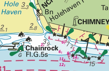
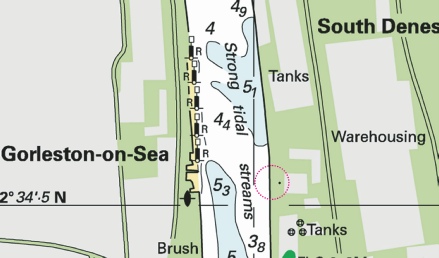
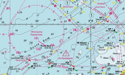


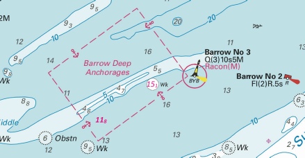

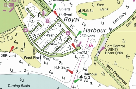

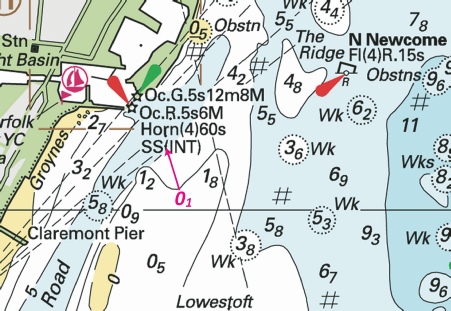


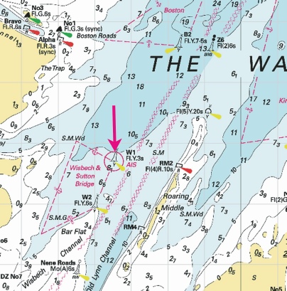


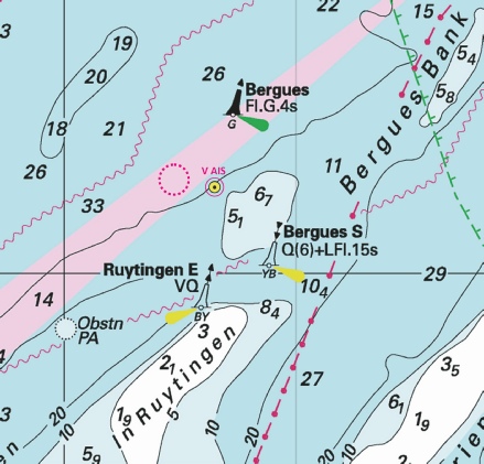

 SYM-
SYM- Q(6)+LFl.15s SYM-
 Fl.Y.5s SYM1
  from: 51° 21´·28N., 3° 12´·47E. to: 51° 21´·27N., 3° 12´·43E.

 Wk
Wk 

 with
with 
 Wk
Wk 
 Wk
Wk 
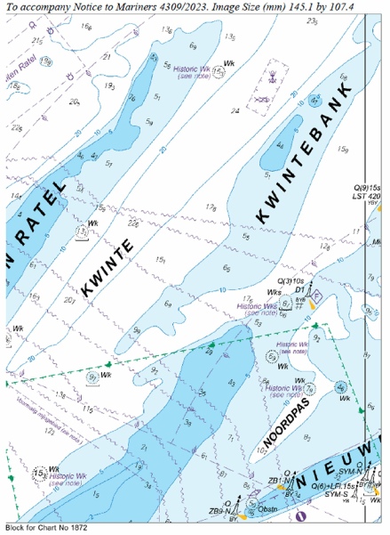
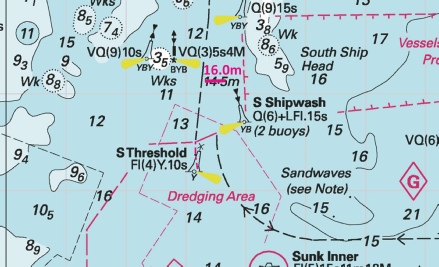

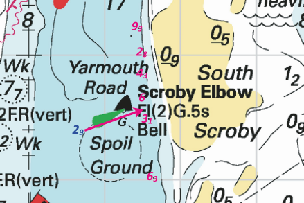

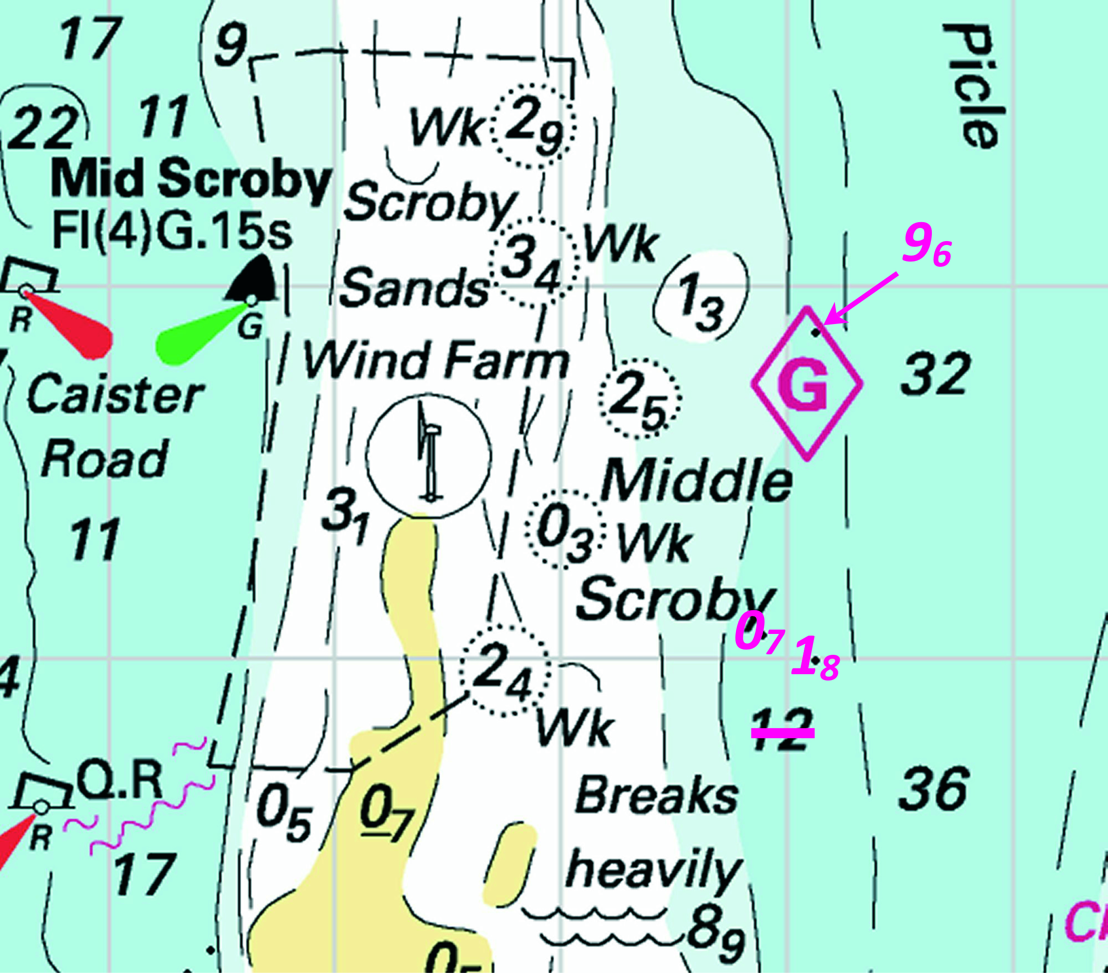

 , joining:
 at 51° 28´·52N., 0° 40´·44E.


 RP-
RP- , within the four special marks above.
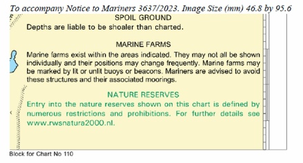


 Fl.Y.5s
  Fl.Y.20s
 Fl(3)G.12s DW17
 Fl.R.4s DW20
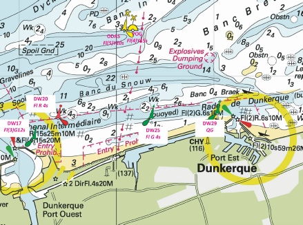


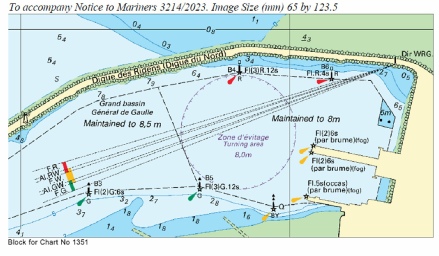


 ,
,


 Q SH4
Q SH4 

 VQ(3)5s SG-
 , from 51° 26´·64N., 3° 33´·32E. to 51° 26´·62N., 3° 33´·46E.

 Fl.Y.5s3M ANS 1 52° 14´·29N., 1° 39´·02E.

 R6
R6 
 R 10
R 10  Iso.R.4s R 14
  VQ(3)5s OR 13-
 Fl(5)Y.20s ODAS EOLOS

 Q(9)15s ZINK-
 Iso.R.8s OG 6A
 at 51° 30´·202N., 0° 00´·387W.


 Fl(5)Y.20s (2 buoys) PA
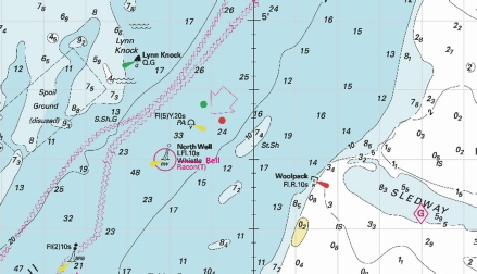

 Fl(4)Y.20s
 , close SE of 51° 42´·32N., 1° 30´·32E.

 at 51° 29´·42N., 0° 47´·32E.
 at:
at:
 at 51° 23´·65N., 1° 12´·10E.
 (INT) SS PA at 51° 07´·157N., 1° 18´·660E.
 , and associated legend,
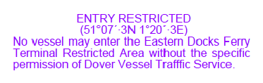


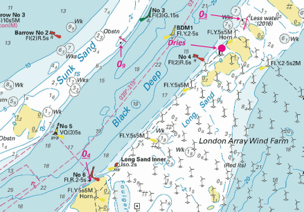


 2F.G(vert) at


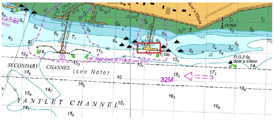
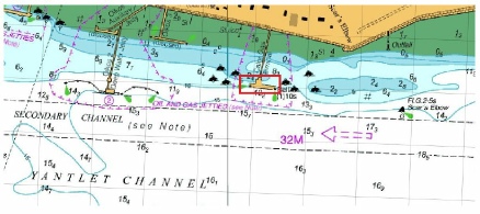


 at 51° 29´·85N., 0° 38´·53E.


 ,at 51° 29´·21N., 0° 47´·46E.
 (12.9)


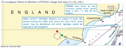
 Fl(2)R.5s at 51° 07´·497N., 1° 20´·279E.

 at 51° 30´·933N., 0° 05´·822E.
 Fl(2)10s Horn(1)20s with
  Fl(2)10s Horn(1)20s at 51° 28´·105N., 0° 14´·701E.
 Q(6)+LFl.15s with
  at 51° 30´·827N., 0° 05´·700E.
 Dn with
  Dn at:
 Siren(2)20s at 51° 30´·404N., 0° 09´·177E., and
 close E.


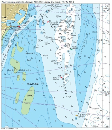
 from: 51° 31´·27N., 0° 42´·43E. to: 51° 31´·23N., 0° 42´·55E.
 from: 51° 31´·33N., 0° 42´·43E. to: 51° 31´·30N., 0° 42´·57E.

 Wk
Wk 


 Obstn
Obstn  ,
, ,
, ,
,

 Fl.Y.2s (Mar-
 , from: 51° 30´·145N., 0° 00´·822E. to: 51° 30´·085N., 0° 00´·867E.


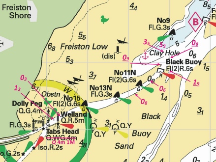


 Fl(5)Y.20s

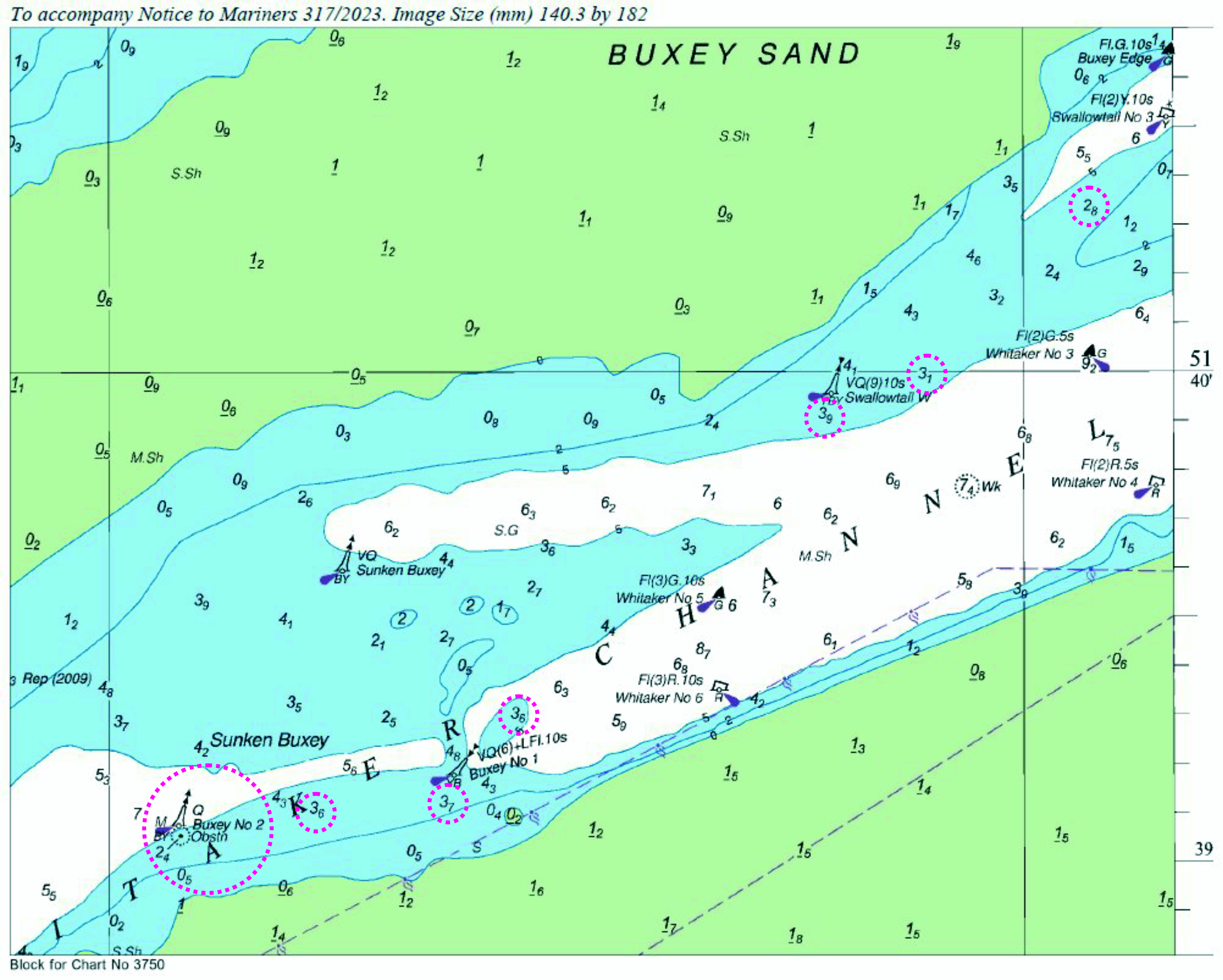


 Fl(5)Y.20s OS 4 with
  at 51° 39´·35N., 3° 41´·64E.