|
Notices - |
||
|
Week 16 |
ENGLAND - Insert: depth, 2.2 at 51° 47´·88N., 1° 37´·22E. Delete depth, 4.5, close NE. depth, 6.9 at 51° 48´·09N., 1° 37´·87E. depth, 11 at 51° 48´·26N., 1° 38´·16E. Notice 1784 refers Base image courtesy of Imray ID10 Chart C1 and Meridian Chartware.
|
Affects: UKHO SNC: 2692. UKHO SCC: 5607.2. Imray Full Charts: C1 Imray Leisure Folios 2000.1 Three new reduced depths for SNC 2692 at the Long Sand Head. A new edition of SNC 2692 was only issued on 28th March! The reduced depths indicate that the Long Sand Head continues the common trend to extend to the NE. I understand it is likely the Long Sand Head North Cardinal which is critical marking the tight corner in the two-
|
|
Week 15 |
ENGLAND - Insert: pontoon, single firm line, joining: 51° 30´·271N., 0° 04´·195W. 51° 30´·273N., 0° 04´·192W. 51° 30´·262N., 0° 04´·159W. 51° 30´·259N., 0° 04´·162W. Notice 1648 refers Base image courtesy of Imray Chart IN5030 and Meridian Chartware.
|
Affects: UKHO SNC: 3337. UKHO SCC: 5606.15A Imray Full Charts: C2 Imray Leisure Folios 2100.4B A new pontoon in the River Thames at the Pool, just upstream of the Hermitage Wharf pontoon.
|
|
Week 15 |
ENGLAND - Insert: depth, 3.4 at 51° 31´·036N., 0° 08´·036E. Delete depth, 3.7 , close W. Notice 1655 refers Base image courtesy of Imray ID10 Chart IN5036 and Meridian Chartware.
|
Affects: UKHO SNC: 2151 (Panel A, Continuation at same scale). UKHO SCC: 5606.14B Imray Full Charts: C2 Imray Leisure Folios 2100.4A One reduction of depth in the River Thames, at Horseshoe Corner in Halfway Reach. Unlikely to hinder leisure craft.
|
|
Week 12 |
ENGLAND - Insert: the accompanying block, centred on: 51° 30´·9N., 0° 08´·3E. Notice 1265 refers Block is copyright of the UKHO.
|
Affects: UKHO SNC: 2151 (Panel A, Continuation at same scale). UKHO SCC: 5606.2 and 5607.2 Imray Full Charts: C2 Imray Leisure Folios 2100.4A A new UKHO block for the River Thames, Halfway Reach off Dagenham.
|
|
Week 10 |
ENGLAND - Delete established direction of traffic flow arrow: On SN Chart 1185 direction 266° centred on: 51° 29´·49N., 0° 48´·89E. direction 282° centred on: 51° 29´·63N., 0° 44´·88E. direction 272° centred on: 51° 30´·16N., 0° 39´·51E. and 51° 30´·28N., 0° 34´·74E. direction 089° centred on: 51° 30´·10N., 0° 33´·05E. direction 092° centred on: 51° 29´·95N., 0° 38´·83E. direction 101° centred on: 51° 29´·36N., 0° 45´·12E. direction 086° centred on: 51° 29´·25N., 0° 48´·84E. On SN Chart 1186 (Panel A, Canvey Island to Coalhouse Point) direction 272° centred on: 51° 30´·249N., 0° 36´·121E. and 51° 30´·293N., 0° 34´·396E. direction 267° centred on: 51° 30´·315N., 0° 32´·755E. direction 260° centred on: 51° 30´·262N., 0° 31´·404E. direction 080° centred on: 51° 30´·025N., 0° 31´·585E. direction 090° centred on: 51° 30´·106N., 0° 32´·870E. direction 094° centred on: 51° 30´·047N., 0° 34´·337E. direction 093° centred on: 51° 30´·025N., 0° 36´·083E. On SN Chart 1606 direction 054° centred on: 51° 33´·47N., 1° 10´·06E. and 51° 32´·10N., 1° 07´·42E. direction 234° centred on: 51° 32´·33N., 1° 07´·21E. and 51° 33´·27N., 1° 10´·40E. On SN Chart 1607 direction 267° centred on: 51° 29´·61N., 0° 52´·37E. direction 086° centred on: 51° 29´·33N., 0° 51´·91E. On SN Chart 1609 direction 234° centred on: 51° 33´·47N., 1° 10´·07E. and 51° 32´·32N., 1° 07´·21E. direction 266° centred on: 51° 29´·56N., 0° 51´·42E. direction 088° centred on: 51° 29´·34N., 0° 51´·18E. direction 055° centred on: 51° 32´·08N., 1° 07´·42E. and 51° 33´·27N., 1° 10´·39E. On SC Chart 5606.7 direction 266° centred on: 51° 29´·49N., 0° 48´·89E. direction 282° centred on: 51° 29´·63N., 0° 44´·88E. direction 102° centred on: 51° 29´·36N., 0° 45´·12E. direction 086° centred on: 51° 29´·25N., 0° 48´·84E. On SC Chart 5606.8 direction 272° centred on: 51° 30´·16N., 0° 39´·51E. and 51° 30´·28N., 0° 34´·74E. direction 089° centred on: 51° 30´·10N., 0° 33´·05E. direction 092° centred on: 51° 29´·95N., 0° 38´·83E. On SC Chart 5606.9 direction 266° centred on: 51° 29´·49N., 0° 48´·90E. direction 282° centred on: 51° 29´·63N., 0° 44´·88E. direction 102° centred on: 51° 29´·36N., 0° 45´·12E. direction 086° centred on: 51° 29´·25N., 0° 48´·84E. On SC Chart 5606.5 direction 267° centred on: 51° 29´·61N., 0° 52´·37E. direction 086° centred on: 51° 29´·33N., 0° 51´·91E. Notice 1106 refers |
Affects: UKHO SNC: 1185, 1186 (Panel A, Canvey Island to Coalhouse Point), 1606, 1607 and 1609. UKHO SCC: 5606.7, 5606.8, 5606.9 and 5606.5 Imray Full Charts: C2 and C1 Imray Leisure Folios 2100.2 and 2100.1 This Notice deletes a total of 42 established direction of traffic flow arrows in the Sea Reach of the River Thames and the Outer Thames. This affects detailed 5 SN charts and 4 SC charts. If the Speaker can break conventions so can I, so I have not illustrated the changes on the grounds that this does not affect leisure craft.
|
|
Week 08 |
ENGLAND - Delete:
51° 29´·942N., 0° 02´·962E. 51° 29´·177N., 0° 00´·103W. 51° 29´·157N., 0° 00´·142W. Notice 873 refers Base image courtesy of Imray ID10 Chart IN5030 and Meridian Chartware.
|
Affects: UKHO SNC: 3337 UKHO SCC: None Old UKHO Leisure Folio: 5606.13 (Panel A, Hole Haven to Gravesend Reach) and 5606.15 (Panel A, Hook Ness to Tower Bridge) Imray Full Charts: C2 Imray Leisure Folios: 2000.4 (Panel B Tower Bridge to Barking Creek) Deletion of three shore based lights alongside in the River Thames: one at jetty of the Thames Refinery just east of the Thames Barrier, two also deleted at the jetty off the Greenwich Power Station.
|
|
Week 07 |
ENGLAND - Replace depth, 1.9, with depth, 0.7 at 51° 29´·931N., 0° 02´·973E. Notice 643 refers Base image courtesy of Imray ID10 Chart IN5030 and Meridian Chartware.
|
Affects: UKHO SNC: 3337 UKHO SCC: 5606.13 (Panel A, Hole Haven to Gravesend Reach) Imray Full Charts: C2 Imray Leisure Folios: 2100.3A Significant reduction of depth right by the jetty off the Thames Refinery on the North Woodwich bank of the River Thames. Not likely to hinder leisure there!
|
|
Week 07 |
ENGLAND - Insert: depth, 4.9, and extend 5m contour W to enclose 51° 27´·906N., 0° 27´·284E. Delete depth, 7.2, close SW. Notice 646 refers Base image courtesy of Imray ID10 Chart IN5036 and Meridian Chartware.
|
Affects: UKHO SNC: 1186 (Panel A, Canvey Island to Coalhouse Point). UKHO SCC: 5606.13 (Panel A, Hole Haven to Gravesend Reach) Imray Full Charts: C2 Imray Leisure Folios: 2100.3A A significant reduction of depth close by the north end of the pontoon off Cliffe Fort, River Thames, Lower Hope Reach . Unlikely to hinder leisure craft.
|
|
Week 06 |
ENGLAND - Source: Port of London Authority Works are in progress at London Gateway Container Terminal, in an area bounded by the following positions: 51° 30´·228N., 0° 28´·060E. 51° 30´·072N., 0° 28´·114E. 51° 30´·196N., 0° 29´·233E. 51° 30´·158N., 0° 29´·243E. 51° 30´·162N., 0° 29´·298E. 51° 30´·090N., 0° 29´·320E. 51° 29´·938N., 0° 27´·979E. 51° 30´·217N., 0° 27´·873E. 51° 30´·237N., 0° 28´·016E. 51° 30´·229N., 0° 28´·022E. 51° 30´·226N., 0° 28´·028E. 51° 30´·224N., 0° 28´·029E. 51° 30´·222N., 0° 28´·038E. Mariners are advised to navigate with caution in the area. Former Notice 1496(T)/23 is cancelled. Notice 515(T) refers Base image courtesy of Imray ID10 Chart IN5036 and Meridian Chartware.
|
Affects: UKHO SNC: 1185 and 1186 UKHO SCC: 5606.13 (Panel A, Hole Haven to Gravesend Reach) Imray Full Charts: C2 Imray Leisure Folios: 2100.3A Long term temporary notice warning of the extension of the Thames Gateway Terminal – west side of the existing terminal and we are recommended to be on the other side of the River.
|
|
Week 04 |
ENGLAND - Insert:
Delete pontoon and associated legend, Pontoon, close NW of 51° 27´·496N., 0° 16´·031E. Notice 345 refers Base image courtesy of Imray ID10 Chart IN5036 and Meridian Chartware.
|
Affects: UKHO SNC: 2151 UKHO SCC: 5606.14 (Panel A Gravesend Reach to Erith Reach) Imray Full Charts: C2 Imray Leisure Folios: 2100.3 New dolphin installed instead of a former pontoon on the south bank of the River Thames in Long Reach east of the QEII bridge. Solely a commercial dolphin.
|
|
Week 03 |
ENGLAND - Insert: depth, 3 at 51° 29´·354N., 0° 11´·001E. Delete depth, 3.8, close NW. Notice 198 refers Base image courtesy of Imray ID10 Chart IN5036 and Meridian Chartware.
|
Affects: UKHO SNC: 2151 (Panel A, continuation at the same scale) UKHO SCC: 5606.14 (Panel A) Imray Full Charts: C2 Imray Leisure Folios: 2100.4A One reduction of depth in the River Thames, Erith Reach right by the downside of the wharf/pontoon off Rainham Marshes. Unlikely to hinder leisure craft.
|
|
Week 03 |
ENGLAND - Insert: depth, 13.8 at 51° 30´·06N., 0° 39´·49E. Delete depth, 14, close W. Notice 203 refers Base image courtesy of Imray ID10 Chart IN5036 and Meridian Chartware.
|
Affects: UKHO SNC: 1185 UKHO SCC: 5606.8 Imray Full Charts: C1 Imray Leisure Folios: 2100.2 One reduction of depth right in the middle of the Yantlet channel, River Thames east of the recommended small craft crossing transit. Not where we ought to be or likely to hinder leisure craft.
|
|
Week 02 |
ENGLAND - Insert: depth, 8.3 at 51° 30´·411N., 0° 10´·121E. Delete depth, 8.4, close W. depth, 6.7 at 51° 30´·331N., 0° 10´·123E. depth, 5.7 at 51° 30´·319N., 0° 10´·109E. Delete depth, 6.1, close W. depth, 8.3 at 51° 30´·305N., 0° 10´·207E. depth, 6.7 at 51° 30´·340N., 0° 10´·311E. depth, 6 at 51° 30´·278N., 0° 10´·192E. Delete depth, 6.1, close SE. depth, 4.5, and extend 5m contour NE to enclose 51° 30´·192N., 0° 10´·334E. Delete depth, 4.7, close NW. depth, 6.7 at 51° 30´·205N., 0° 10´·350E. depth, 9 at 51° 30´·202N., 0° 10´·414E. Delete depth, 9.3, close SW. Notice 111 refers Base image courtesy of Imray ID10 Chart IN5036 and Meridian Chartware.
|
Affects: UKHO SNC: 2151 (Panel A, continuation at the same scale) UKHO SCC: 5606.14 (Panel A) Imray Full Charts: C2 Imray Leisure Folios: 2100.4 A cluster of 9 reductions of depth in the River Thames in Erith Reach off Jenningtree Point. Unlikely to hinder leisure craft.
|
|
SCROLL DOWN FOR PRE- |
||
|
Week 52 |
ENGLAND - Insert: depth, 6.1 at 51° 30´·494N., 0° 33´·368E. Delete depth, 6.4, close E. depth, 6.1 at 51° 30´·423N., 0° 33´·326E. Delete depth, 6.2, close NW. 8.2 at 51° 30´·411N., 0° 33´·417E. Delete depth, 8.7, close NE. 11.8 at 51° 30´·371N., 0° 33´·349E. Delete depth, 12.5, close E. depth, 12.3 at 51° 30´·329N., 0° 33´·354E. Delete depth, 14.4, close SE. Replace: depth, 3, with depth, 2.7 at 51° 30´·47N., 0° 33´·13E. depth, 14.3, with depth, 14.1 at 51° 30´·379N., 0° 33´·503E. Notice 4961 refers Base image courtesy of Imray ID10 Chart IN5036 and Meridian Chartware.
|
Affects: UKHO SNC: 1185 and 1186 (Panel A, Canvey Island to Coalhouse Point) UKHO SCC: 5606.8 Imray Full Charts: C2 Imray Leisure Folios: 2000.2 Seven reductions of depth in the River Thames off Hole Haven and the Tanker Jetties. Unlikely to hinder leisure craft.
|
|
Week 52 |
ENGLAND - Insert depth, 11.8 at 51° 30´·20N., 0° 38´·23E. Delete depth, 12.4, close S. Notice 5014 refers Base image courtesy of Imray ID10 Chart IN5037 and Meridian Chartware.
|
Affects: UKHO SNC: 1185 UKHO SCC: 5606.8 Imray Full Charts: C2 Imray Leisure Folios: 2000.2 One reduction of depth right in the centre of the Yantlet Channel close to the recommended Small Craft Crossing transit twixt the West Leigh Middle and East Blyth buoys. At 11.8m it is unlikely to hinder any leisure craft but the Pilot of a Panamax might be concerned and a New Panamax v. worried!
|
|
Week 52 |
ENGLAND - Insert: depth, 8.7, and extend 10m contour S to enclose 51° 27´·399N., 0° 26´·384E. Delete depth, 11.4, close SE. Notice 5050 refers Base image courtesy of Imray ID10 Chart IN5036 and Meridian Chartware.
|
Affects: UKHO SNC: 1186 (Panel A, Canvey Island to Coalhouse Point) UKHO SCC: 5606.8 Imray Full Charts: C2 Imray Leisure Folios: 2000.3 One reduction of depth in the River Thames, Lower Hope Reach, close south of the Ovens SHB. Unlikely to hinder leisure craft.
|
|
Week 51 |
ENGLAND - Insert: depth, 8.1 at 51° 27´·857N., 0° 17´·754E. Delete depth, 8.2, close NE and depth, 8.2, close S. Notice 4880 refers Base image courtesy of Imray ID10 Chart IN5036 and Meridian Chartware.
|
Affects: UKHO SNC: 2151 UKHO SCC: 5665.14 (Panel A, Gravesend Reach to Erith Reach. Imray Full Charts: C2 Imray Leisure Folios: 2100.3 (Panel B Queen Elizabeth Bridge to Coalhouse Point). One small, very small reduction of depth on the edge of the main channel of the River Thames at Fiddler’s Reach (West Thurrock). Unlikely to hinder leisure craft.
|
|
Week 49 |
ENGLAND - Insert: depth, 13.9 at 51° 30´·164N., 0° 30´·915E. Delete depth, 14, close W. Notice 4579 refers Base image courtesy of Imray ID10 Chart C2 and Meridian Chartware.
|
Affects: UKHO SNC: 1186 (Panel A, Convey Island to Coalhouse Point) UKHO SCC: 5605.14, 5606.5 and 5606.2. Imray Full Charts: C2 Imray Leisure Charts: 2100.2 This a matter of precision: one (tiny) reduction of depth on the northern edge of the Yantlet Channel opposite Cliffe Fleet in the River Thames. Very unlikely to hinder leisure craft.
|
|
Week 44 |
ENGLAND - Insert: depth, 3.2 at 51° 30´·330N., 0° 00´·302E. Delete depth, 3.5, close N. depth, 5.1 at 51° 30´·178N., 0° 00´·656E. depth, 1.7, and extend 2m contour SE to enclose 51° 30´·152N., 0° 00´·544E. Replace: depth, 2.3, with depth, 1.5, and extend 2m contour N to enclose 51° 30´·125N., 0° 00´·575E. Notice 3926 refers Base image courtesy of Imray ID10 Chart IN5030 and Meridian Chartware.
|
Affects: UKHO SNC: 3337 UKHO SCC: 5606.15 Imray Full Charts: C2 Imray Leisure Charts: 2100.4 4 reductions of depth in the River Thames, one in the centre of Bugsby Reach, a second on the edge of the channel of the Reach and two soundings off North Greenwich Pier.
|
|
Week 42 |
ENGLAND - Replace: symbol, black unlit beacon with sphere topmark, Yantlet Beacon, with Notice 3746 refers Base image courtesy of Imray ID10 Charts IN5037 and Meridian Chartware.
|
Affects: UKHO SNC: 1185 UKHO SCC: 5606.8 Imray Full Charts: C2 Imray Leisure Charts: 2100.2 The Yantlet Beacon which used to mark the entrance of the Yantlet Creek at Allhallows Marsh on the north side of the Isle of Grain has gone leaving an obstruction.
|
|
Week 41 |
ENGLAND - Insert depth, 2.9 at 51° 29´·830N., 0° 01´·648E. Delete depth, 3.4, close NW and depth, 3.1 at 51° 29´·837N., 0° 01´·702E. depth, 5.7 at 51° 29´·733N., 0° 01´·648E. Delete depth, 5.8, close NE. Replace: depth, 2.8, with depth, 4.4 at 51° 29´·747N., 0° 02´·521E. Notice 3678 refers Base image courtesy of Imray ID10 Chart IN5030 and Meridian Chartware.
|
Affects: UKHO SNC: 3337 (Panel B, Thames Tidal Barrier) and 3337 Imray Full Charts: C2 Imray Leisure Charts: 2100.3 Two reductions of depth west of the Thames Barrier and an increase of depth at the Barrier Garden Pier east of the Thames Barrier.
|
|
Week 37 |
ENGLAND - Insert: depth, 8.9 at 51° 26´·993N., 0° 21´·581E. Delete depth, 9.3, close E. depth, 10, enclosed by 10m contour at 51° 26´·958N., 0° 21´·846E. Delete depth, 10.1, close E. Replace: depth, 10.5, with depth, 10, and extend 10m contour NW to enclose 51° 27´·019N., 0° 21´·814E. Notice 3165 refers Base image courtesy of Imray ID10 Charts IN5036 and Meridian Chartware.
|
Affects: UKHO SNC: 1186 (Panel B, Coalhouse Point to Tilbury) and 2151 UKHO SCC: 5606.13 Imray Full Charts: C2 Imray Leisure Charts: 2100.3 Three small reductions of depth in Gravesend Rach, River Thames. Unlikely to hinder leisure craft.
|
|
Week 32 |
ENGLAND - A temporary exclusion zone has been established in an area bounded by the following positions whilst demolition works take place: 51° 30´·577N., 0° 02´·637W. 51° 30´·538N., 0° 02´·624W. 51° 30´·526N., 0° 02´·684W. 51° 30´·497N., 0° 02´·770W. 51° 30´·549N., 0° 02´·819W. 51° 30´·572N., 0° 02´·708W. No vessel shall navigate or remain within this exclusion zone, except those permitted by the PLA to make use of Stone Stairs barge moorings or by prior permission of London VTS. Mariners are advised to navigate with caution in the area. Notice 2665(T) refers Base image courtesy of Imray ID10 Charts IN5030 and Meridian Chartware.
|
Affects: UKHO SNC: 3337 UKHO SCC: 5606.15 Imray Full Charts: C2 Imray Leisure Charts: 2100.4 A temporary exclusion zone for emergency demolition works at the Free Trade Wharf west of Limehouse Marina.
|
|
Week 30 |
ENGLAND - Insert: depth, 9.4 at 51° 28´·499N., 0° 27´·217E. Delete depth, 9.6, close S. Replace: depth, 8.7, with depth, 8.6 at 51° 27´·137N., 0° 25´·726E. depth, 9.2, with depth, 9.1 at 51° 26´·925N., 0° 25´·373E. Notice 2550 refers Base image courtesy of Imray ID10 Charts IN5036 and Meridian Chartware.
|
Affects: UKHO SNC: 1186 (INT 1426) (Panel A, Canvey Island to Coalhouse Point) and Chart 1186 (INT 1426) (Panel B, Coalhouse Point to Tilbury) UKHO SCC: 5605.11 Imray Full Charts: C2 Imray Leisure Charts: C2100.3 Three slight reduction of depth in the River Thames, one in the middle of the channel in Lower Hope Reach and two in the channel off Tilbury SCB. Unlikely to hinder leisure craft.
|
|
Week 29 |
ENGLAND - Insert: depth, 9.5 at 51° 26´·959N., 0° 23´·548E. Notice 2443 refers Base image courtesy of Imray ID10 Charts C2 and Meridian Chartware.
|
Affects: UKHO SNC: 1186 (Panel B, Coalhouse Point to Tilbury) UKHO SCC: 5606.13 Imray Full Charts: C2 Imray Leisure Charts: C2120.3 One reduction of depth on the Diver Shoal in Gravesend Reach of the River Thames. At over 9m, unlikely to hinder leisure craft.
|
|
Week 27 |
ENGLAND - Insert: depth, 1.3 at 51° 30´·349N., 0° 00´·130E. Delete depth, 1.7, close W. depth, 4.7 at 51° 29´·312N., 0° 00´·100W. Delete depth, 4.9, close NW. depth, 4.5 at 51° 29´·217N., 0° 00´·165W. Delete depth, 6.3, close E. depth, 3.6, and extend 5m contour S to enclose 51° 29´·159N., 0° 00´·491W. depth, 5.9 at 51° 29´·138N., 0° 00´·510W. Delete depth, 6.4, close E.
Notice 2209 refers Base image courtesy of Imray ID10 Chart IN5030 and Meridian Chartware.
|
Affects: UKHO SNC: 3337. UKHO SCC: 5606.15. Imray Full Charts: C2 Imray Leisure Charts: 2100.4. 5 reductions of depth and one new light(!) at Blackwall and Greenwich: one reduced depth just off Blackwall Point and a ‘new’ light off Blackwall Basin. I say ‘new’ because the light is already marked on Imray. The remaining reductions are in Greenwich Reach. Two images:
|
|
Week 27 |
ENGLAND - Insert: depth, 6.7 at 51° 28´·163N., 0° 15´·071E. Delete depth, 6.8, close E. Notice 2228 refers Base image courtesy of Imray ID10 Chart IN5036 and Meridian Chartware.
|
Affects: UKHO SNC: 2151. UKHO SCC: 5606.14 Imray Full Charts: C2 Imray Leisure Charts: C2100.4 One small reduction of depth close to the jetties at Purfleet. Unlikely to hinder leisure craft and not where you out to be!
|
|
Week 27 |
ENGLAND - Insert: depth, 4.2 , and extend 5m contour NE to enclose 51° 29´·504N., 0° 00´·043W. Delete depth 4.7 , close SE. Notice 2272 refers Base image courtesy of Imray ID10 Chart IN5030 and Meridian Chartware.
|
Affects: UKHO SNC: 3337. UKHO SCC: 5606.15. Imray Full Charts: C2 Imray Leisure Charts: 2100.4. Notice 1705 in week 21 notified three reduction of depth in Greenwich Reach. This notice is revising and reducing one of those soundings. Unlikely to hinder leisure craft.
|
|
Week 26 |
New Editions of ADMIRALTY Charts to be published 13 July 2023 SNC 1975 England - |
Includes changes to depths from the latest Port of London Authority and Trinity House surveys. |
|
Week 26 |
ENGLAND - Replace:
depth, 13.3, with depth, 13.2 at 51° 29´·40N., 0° 47´·57E. Notice 2202 refers Base image courtesy of Imray ID10 Chart ON5043 and Meridian Chartware.
|
Affects: UKHO SNC: 1185. UKHO SCC: 5606.7 and 5606.9 Imray Full Charts: C1 Imray Leisure Charts: C2100.2 A small change of depth over an ‘Obstn’ and a similarly small reduction of depth close by in the Yantlet Channel off Shoeburyness. Unlikely to hinder leisure craft.
|
|
Week 25 |
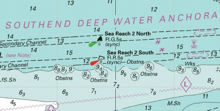
ENGLAND - Insert: 51° 29´·83N., 0° 49´·54E. 51° 29´·77N., 0° 49´·61E. 51° 29´·71N., 0° 49´·35E. 51° 29´·72N., 0° 49´·25E. Notice 2112 refers Base image courtesy of Imray ID10 Chart ON5037 and Meridian Chartware.
|
Affects: UKHO SNC: 1185 and 1609. UKHO SCC: 5606.7 and 5606.9 Imray Full Charts: C1 Imray Leisure Charts: C2100.2 Four new ‘FOULS’ in the Southend Deep Water Anchorage south of the Shoebury Beacon. Unlikely to be an anchorage for leisure craft!
|
|
Week 24 |
ENGLAND - Replace:
Notice 1982 refers Base image courtesy of Imray ID10 Chart C1 and Meridian Chartware.
|
Affects: UKHO SNC: 1183 and 1607. UKHO SCC: 5606.4, 5606.5 and 5606.2. Imray Full Charts: C1 Imray Leisure Charts: 2100.1 Revised depth over a dangerous wreck west of the Reculver Port hand Buoy (North Kent coast route). Worth noting at 1.8m.
|
|
Week 21 |
ENGLAND - Insert: depth, 4.5 , and extend 5m contour E to enclose 51° 29´·556N., 0° 00´·043W. depth, 4.7 , and extend 5m contour E to enclose 51° 29´·485N., 0° 00´·028W. depth, 2.6 at 51° 29´·093N., 0° 00´·417W. Notice 1705 refers Base image courtesy of Imray ID10 Chart IN5030 and Meridian Chartware.
|
Affects: UKHO SNC: 3337 UKHO SCC: 5606.1. Imray Full Charts: C2 Imray Leisure Charts: 2100.4. Three reductions of depth in the River Thames off Millwall and Greenwich. Unlikely to hinder leisure craft.
|
|
Week 18 |
ENGLAND - Insert: depth, 10.3 at 51° 28´·413N., 0° 14´·617E. Delete depth, 10.5, close W. depth, 3.7 at 51° 31´·036N., 0° 08´·021E. Notice 1552 refers Base image courtesy of Imray ID10 Chart IN5036 and Meridian Chartware.
|
Affects: UKHO SNC: 2151 and 2151 (Panel A, Continuation of the same scale) UKHO SCC: 5606.14 A and B Imray Full Charts: C2 Imray Leisure Charts: 2100.4 A. Two reduced depths close to commericla jetties in the River Thames. One in Long Reach off the Purfleet tankage; the other west of Dagenham in Halfway Reach by Dagenham Docks. Unlikely to be close to where we are!
|
|
Week 18 |
ENGLAND - Insert: depth, 1.8, enclosed by 2m contour at 51° 30´·87N., 0° 39´·85E. Delete depth, 2.3, close N. Notice 1554 refers Base image courtesy of Imray ID10 Chart IN5037 and Meridian Chartware.
|
Affects: UKHO SNC: 1185 UKHO SCC: 5606.8 Imray Full Charts: C2 Imray Leisure Charts: 2100.2 One reduction of depth to 1.8 just south of the Leigh Middle Sand in Sea Reach, River Thames.
|
|
Week 18 |
ENGLAND - Insert: depth, 6.9 at 51° 27´·292N., 0° 20´·358E. Delete depth, 7.2, close W. Notice 1571 refers Base image courtesy of Imray ID10 Chart IN5036 and Meridian Chartware.
|
Affects: UKHO SNC: 1186 (Panel B, Coalhouse Point to Tilbury) and 2151 UKHO SCC: 5606.14 Imray Full Charts: C2 Imray Leisure Charts: 2100.3B One reduction of depth right in the middle of the lock entrance to Tilbury Docks, Northfleet Hope, River Thames. Not likely to hinder leisure craft.
|
|
Week 17 |
ENGLAND - Replace: depth, 5.9, with depth, 5.7 at 51° 29´·895N., 0° 02´·705E. Notice 1419 refers Base image courtesy of Imray ID10 Chart IN5030 and Meridian Chartware.
|
Affects: UKHO SNC: 3337 (Panel B, Thames Tidal Barrier) and 3337 UKHO SCC: 5606.7, 5606.9 and 5606.5 Imray Full Charts: C2 Imray Leisure Charts: 2100.4 One slight reduction of depth east of the Thames Barrier. Unlikely to hinder leisure craft..
|
|
Week 17 |
ENGLAND - Works are in progress at the Calor Gas Terminal jetty, until 13th October 2023, in an area bounded by the following positions: 51° 30´·417N., 0° 34´·041E. 51° 30´·403N., 0° 34´·175E. 51° 30´·362N., 0° 34´·165E. 51° 30´·374N., 0° 34´·028E. Works are in progress at London Gateway Container Terminal, until approximately August 2023, in an area bounded by the following positions: 51° 30´·228N., 0° 28´·060E. 51° 30´·072N., 0° 28´·114E. 51° 30´·196N., 0° 29´·233E. 51° 30´·158N., 0° 29´·243E. 51° 30´·162N., 0° 29´·298E. 51° 30´·090N., 0° 29´·320E. 51° 29´·938N., 0° 27´·979E. 51° 30´·217N., 0° 27´·873E. 51° 30´·237N., 0° 28´·016E. 51° 30´·229N., 0° 28´·022E. 51° 30´·226N., 0° 28´·028E. 51° 30´·224N., 0° 28´·029E. 51° 30´·222N., 0° 28´·038E. Mariners are advised to navigate with caution in the area. Notice 1496(T) refers Image courtesy of the Port of London Authority local notice
|
Affects: UKHO SNC: 1185 and 1186 UKHO SCC: 5606.8 Imray Full Charts: C2 Imray Leisure Folios: 2100.3 Works in progress until mid October at the Calor Gas Terminal in the Sea Reach, River Thames east of the Hole Haven.
|
|
Week 17 |
ENGLAND - Insert: depth, 9.3 at 51° 26´·993N., 0° 21´·601E. Delete depth, 9.4, close NW. Notice 1507 refers Base image courtesy of Imray ID10 Chart IN5036 and Meridian Chartware.
|
Affects: UKHO SNC: 1186 (Panel B, Coalhouse Point to Tilbury) and 2151 UKHO SCC: 5606.14 Imray Full Charts: C2 Imray Leisure Folios: 2100.3 One reduction of depth in Gravesend Reach, River Thames. At 9.3m, unlikely to hinder leisure craft.
|
|
Week 17 |
ENGLAND - Insert:
Notice 1523 refers Base image courtesy of Imray ID10 Chart IN5037 and Meridian Chartware.
|
Affects: UKHO SNC: 1185, 1609 and 3683 UKHO SCC: 5606.7 and 5606.9 Imray Full Charts: C2 Imray Leisure Folios: 2100.2 One new ‘obstn’ on the eastern tail of the Nore Sand in Sea Reach, River Thames. Not a suitable place to anchor!
|
|
Week 16 |
ENGLAND - Insert: depth, 13.3 at 51° 29´·40N., 0° 52´·43E. Delete depth, 13.4, close E. depth, 14.2, and extend 15m contour S to enclose 51° 31´·81N., 1° 05´·74E. depth, 15, and extend 15m contour SE to enclose 51° 32´·43N., 1° 07´·70E. Delete depth, 15.2, close SW. depth, 14.4 at 51° 32´·37N., 1° 07´·72E. Delete depth, 14.6, close S. depth 8.1 at 51° 29´·49N., 1° 07´·63E. Delete depth, 8.4, close W and depth 8.3 close E. depth 7.2 at 51° 29´·38N., 1° 06´·75E. Delete depth, 7.3, close E and depth, 5.8, close SE. depth, 12.6 at 51° 29´·09N., 0° 54´·89E. Delete depth, 11.4, close N. depth, 13 at 51° 31´·51N., 1° 04´·56E. Delete depth, 15.9, close E. Replace: depth, 15.5, with depth, 15.4 at 51° 32´·08N., 1° 07´·20E. depth, 14.7, with depth, 14.5 at 51° 32´·48N., 1° 08´·01E. depth, 7.9, with depth, 7.8 at 51° 29´·36N., 1° 07´·63E. Notice 1358 refers Base image courtesy of Imray ID10 Chart IN5043 and Meridian Chartware.
|
Affects: UKHO SNC: 1185, 1606, 1607 and 1609 UKHO SCC: 5606.7, 5606.9 and 5606.5 Imray Full Charts: C1 Imray Leisure Charts: 2100.1 and 2100.2 11 reductions of depth, 2 around the sea Reach No 1 area and West Oaze, 3 around the Princes Nos 6 and 7 buoys and 6 in the Mouse and Knock John Channels. All unlikely to hinder leisure craft.
|
|
Week 16 |
ENGLAND - Insert depth, 12.9 at 51° 30´·41N., 0° 35´·71E. Delete depth, 14.2 close NE. depth, 2.8, and extend 5m contour N to enclose 51° 29´·78N., 0° 36´·88E. Delete depth, 3.8, close SW. (sounding out of position on SCC 5606.8) Replace: depth, 6.6 , with depth, 4.3, and extend 5m contour N to enclose 51° 29´·80N., 0° 37´·19E. Delete:
Notice 1407 refers Base image courtesy of Imray ID10 Chart IN5047 and Meridian Chartware.
|
Affects: UKHO SNC: 1185 and 1186 (Panel A, Canvey Island to Coalhouse Point) UKHO SCC: 5606.8 Imray Full Charts: C2 Imray Leisure Charts: 2100.2 Three reductions of depth, one off Canvey Island, River Thames and two off Sheppey close to the Small Craft Crossing point. Also ne wreck deleted east of the East Blyth buoy.
|
|
Week 13 |
ENGLAND - Insert: depth, 5.5 at 51° 30´·789N., 0° 06´·857E. Delete depth, 5.8, close W. depth, 4.7, and extend 5m contour SE to enclose 51° 30´·815N., 0° 06´·845E. Delete depth, 5, close W. depth, 4.3 at 51° 30´·848N., 0° 06´·847E. Delete depth, 4.5, close SW. depth, 6.7 at 51° 30´·811N., 0° 07´·028E. depth, 7.4 at 51° 29´·626N., 0° 10´·712E. depth, 6.3 at 51° 29´·584N., 0° 10´·753E. Replace: depth, 6.9, with depth, 6.8 at 51° 30´·883N., 0° 07´·177E Notice 1196 refers Base image courtesy of Imray ID10 Chart C2 and Meridian Chartware.
|
Affects: UKHO SNC: 2151 (Panel A, Continuation at same scale) UKHO SCC: 5605.14 Imray Full Charts: C2 Imray Leisure Folios: 2100.3 A ‘cluster’ of 5 reduced depths in Barking Reach and 2 in Erith Reach, River Thames. All unlikely to hinder leisure craft.
|
|
Week 12 |
ENGLAND - Insert: depth, 8.4 at 51° 27´·524N., 0° 16´·558E. Delete depth, 8.5, close E. depth, 8.3 at 51° 27´·543N., 0° 16´·480E. Delete depth, 8, close N. depth, 5.2 at 51° 30´·479N., 0° 05´·231E. Delete depth, 5.4, close NE.
depth, 8.5 at 51° 30´·361N., 0° 10´·099E. Delete depth, 9.3, close NE. depth, 4.7, and extend 5m contour N to enclose 51° 30´·205N., 0° 10´·314E. Delete depth, 4.9, close SE. depth, 3.6 at 51° 29´·870N., 0° 01´·302E. Delete depth, 4.1, close NW. Replace:
depth, 3.5, with depth, 3 at 51° 27´·637N., 0° 19´·314E. depth, 8.5, with depth, 8.4 at 51° 30´·424N., 0° 10´·057E.
51° 29´·885N., 0° 03´·779E and. 51° 29´·890N., 0° 03´·865E. 51° 31´·595N., 0° 05´·516E. (at Welbeck Wharf in Barking Creek) Delete:
Notice 1087 refers Base image courtesy of Imray ID10 Chart C2 and Meridian Chartware.
|
Affects: UKHO SNC: 2151, 2151 (Panel A, Continuation at same scale), 3337 and 3337 (Panel A, Barking Creek) UKHO SCC: 5605.14 Imray Full Charts: C2 Imray Leisure Folios: 2100.3, 2100.4 A complicated Notice to Mariners in the River Thames listing 8 reduction of depth, deletion of 2 shore side lights, installation of one shore side light, 23 dolphins and a change of beacon. All this between Woolwich Reach and Erith. 5 images illustrating the changes. None of the depths are likely to hinder leisure craft.
|
|
Week 10 |
ENGLAND - Insert depth, 3.8 at 51° 29´·255N., 0° 01´·399W. depth, 1.9, and extend 2m contour S to enclose 51° 29´·223N., 0° 01´·305W. Delete: depth, 6.3 at 51° 29´·256N., 0° 01´·474W. depth, 4.8 at 51° 29´·278N., 0° 01´·448W. Notice 855 refers Base image courtesy of Imray ID10 Chart IN5030 and Meridian Chartware.
|
Affects: UKHO SNC: 3337 UKHO SCC: 5606.15 Imray Full Charts: C2 Imray Leisure Folios: 2100.4 Two reductions of depth close by the Masthouse Terrace Pier at Greenwich Reach.
|
|
Week 10 |
ENGLAND - Insert depth, 8 at 51° 28´·271N., 0° 14´·771E. Delete depth, 7.8, close SE. depth, 6.9 at 51° 28´·238N., 0° 14´·858E. Delete depth, 7.2, close SE. depth, 4.6, and extend 5m contour S to enclose 51° 29´·779N., 0° 01´·896E. Delete depth, 4.8, close N. Notice 932 refers Base image courtesy of Imray ID10 Chart IN5030 and IN5036 and Meridian Chartware.
|
Affects: UKHO SNC: 2151, 3337 (Panel B, Thames Tidal Barrier) and 3337 UKHO SCC: 5606.13 and 5606.14 Imray Full Charts: C2 Imray Leisure Folios: 2100.3 Two reductions of depth in Long Reach, Purfleet and one mid stream west of the Thames barrier. Unlikely to hinder leisure craft.
|
|
Week 9 |
ENGLAND - Insert depth, 9.5 at 51° 27´·049N., 0° 23´·920E. Replace: depth, 7.4, with depth, 7.3 at 51° 26´·875N., 0° 23´·377E. Notice 789 refers Base image courtesy of Imray ID10 Chart IN5043 and Meridian Chartware.
|
Affects: UKHO SNC: 1186 (Panel B, Coalhouse Point to Tilbury) UKHO SCC: 5606.14 Imray Full Charts: C2 Imray Leisure Folios: 2100.3 Two reductions of depth in the Gravesend Reach off the West Tilbury Marshes. Unlikely to hinder leisure craft.
|
|
Week 8 |
ENGLAND - Insert:
Move:
Notice 650 refers Base image courtesy of Imray ID10 Chart C2 and Meridian Chartware.
|
Affects: UKHO SNC: 3337 UKHO SCC: 5606.15 Imray Full Charts: C2 Imray Leisure Folios: 2100.4 New yellow special lit buoy (seasonal) just north of the )2 arena and one move of a ships mooring in Bugsby Reach.
|
|
|
|
|
|
Week 7 |
ENGLAND - Replace: depth, 8.7 , with depth, 8.6 at 51° 27´·188N., 0° 25´·912E. Notice 613 refers Base image courtesy of Imray ID10 Chart C2 and Meridian Chartware.
|
Affects: UKHO SNC: 1186 Panel A, Canvey Island to Coalhouse Point) and 1186 Imray Full Charts: C2 Imray Leisure Folios: 2100.3 One slight increase of depth just off Tilbury. Unlikely to hinder leisure craft!
|
|
Week 4 |
ENGLAND - Insert: depth, 12.7 at 51° 29´·45N., 0° 48´·22E. depth, 13.7 at 51° 29´·35N., 0° 48´·50E. depth, 13.8 at 51° 29´·41N., 0° 50´·49E. Delete depth, 14 and 13.9, close SW. Notice 248 refers Base image courtesy of Imray ID10 Chart IN5037 and Meridian Chartware.
|
Affects: UKHO SNC: 1185 and 1609 UKHO SCC: 5606.7 and 5606.9 Imray Full Charts: C1 Imray Leisure Folios: 2100.2 Three slight reductions of depth in the primary and secondary Yantlet Channel in Sea Reach of the London River. Unlikely to hinder leisure craft and ‘not where we ought to be’ anyway.
|
|
Week 4 |
ENGLAND - Insert: depth, 8.2 at 51° 28´·192N., 0° 19´·051E. Delete depth, 6.4 , close NE. Replace: depth, 6.3 , with depth, 6.2 at 51° 28´·235N., 0° 18´·993E. Notice 272 refers Base image courtesy of Imray ID10 Chart C2 and Meridian Chartware.
|
Affects: UKHO SNC: 2151 Imray Full Charts: C2 Imray Leisure Folios: 2000.3B One increase and one decrease of depth close to the White Hart SHB off Thurrock Yacht Club, River Thames. Unlikely to hinder leisure craft.
|
|
Week 2 |
ENGLAND - Insert: depth, 5.6 at 51° 29´·790N., 0° 01´·361E. Notice 91 refers Base image courtesy of Imray ID10 Chart C2 and Meridian Chartware.
|
Affects: UKHO SNC: 3337 Imray Full Charts: C2 Imray Leisure Folios: 2100.4 One reduction of depth in the centre of the river at the Woolwich Reach, River Thames. Unlikely to hinder leisure craft.
|
|
SCROLL DOWN FOR PRE- |
||
|
Week 50 |
ENGLAND - Insert: legend, Works in progress (2022 - Notice 4956 refers Base image courtesy of Imray ID10 Chart C2 and Meridian Chartware.
|
Affects: UKHO Charts: 3337 UKHO Leisure Charts: 5606.6 Imray Charts: C2 Imray Leisure Charts: 2100.4B This notice is reporting ‘works in progress 2022 to 2023 at Brewery Wharf in Deptford Creek.
|
|
Week 49 |
ENGLAND - Insert: depth, 7.5 at 51° 29´·267N., 0° 27´·920E. Delete depth, 7.8, close SE. Replace: depth, 8.8, with depth, 8.7 at 51° 29´·698N., 0° 28´·102E. Notice 4862 refers Base image courtesy of Imray ID10 Chart C2 and Meridian Chartware.
|
Affects: UKHO Charts: 1186 (Panel A, Canvey Island to Coalhouse Point) UKHO Leisure Charts: 5606.6 Imray Charts: C2 Imray Leisure Charts: 2100.3 Two reduction of depth, one just SW of the Lower Hope PHB, the second right by the Mucking No 1 SHB both in Little Hope Reach, River Thames. Unlikely to hinder leisure craft.
|
|
Week 48 |
ENGLAND - Insert: depth, 13.7 at 51° 30´·19N., 0° 32´·57E. Delete depth, 13.9, close NE. depth, 13.6 at 51° 30´·13N., 0° 36´·42E. Delete depth, 13.8, close E. depth, 13.8 at 51° 30´·189N., 0° 32´·496E. depth, 10.7 at 51° 30´·027N., 0° 36´·424E. Delete depth, 10.9, close SE. Replace: depth, 14.9, with depth, 14.7 at 51° 30´·08N., 0° 35´·09E. Delete depth, 13.9 at 51° 30´·23N., 0° 32´·79E. Notice 4794 refers Base image courtesy of Imray ID10 Chart C2 and Meridian Chartware.
|
Affects: UKHO Charts: 1185 and 1186 (Panel A, Convey Island to Coalhouse Point) and 1609 UKHO Leisure Charts: 5606.8 Imray Charts: C2 Imray Leisure Charts: Y18.1, 2100.2 Five new depths in and around the main Yantlet Channel in River Thames, Sea Reach. Unlikely to hinder leisure craft.
|
|
Week 48 |
ENGLAND - Insert: depth, 7.2 at 51° 27´·428N., 0° 26´·391E. Delete depth, 8.2, close SE. depth, 8.7 at 51° 26´·897N., 0° 23´·270E. Delete depth, 8.8, close S. depth, 7.4 at 51° 26´·875N., 0° 23´·377E. Delete depth, 7.5, close E. depth, 8 at 51° 26´·890N., 0° 23´·509E. Delete depth, 8.5, close SE. depth, 8.5 at 51° 26´·897N., 0° 23´·658E. Delete depth, 8.6, close SW. Notice 4844 refers Base image courtesy of Imray ID10 Chart C2 and Meridian Chartware.
|
Affects: UKHO Charts: 1186 (Panel A, Convey Island to Coalhouse Point) and 1186 (Panel B, Coalhouse Point to Tilbury) UKHO Leisure Charts: 5606.13 Imray Charts: C2 Imray Leisure Charts: 2100.3 Five reductions of depth in Gravesend Reach of the River Thames. Unlikely to hinder leisure craft.
|
|
Week 45 |
ENGLAND - Insert: depth, 3.4 at 51° 29´·883N., 0° 02´·127E. Delete depth, 4.4, close E. Notice 4384 refers Base image courtesy of Imray ID10 Chart C2 and Meridian Chartware.
|
Affects: UKHO Charts: 3337 and 3337 (Panel B, Thames Tidal Barrier) UKHO Leisure Charts: 5606.2 and 5606.5 Imray Charts: C2 Imray Leisure Charts: 2100.4 One reduction of depth on the west side of the Thames Barrier, close to the north bank. Unlikely to hinder leisure craft (the image includes two reductions of depth notified vide NtM 3653 in week 37.
|
|
Week 42 |
New Editions of ADMIRALTY Small Craft Charts to be published on 3rd November, 2022 SCC 5606.7 Havengore Bridge to Southend- SCC 5606.8 Southend- 1:25,000 SCC 5606.9 Medway Approach Channel.. 1:25,000 SCC 5606.10 Mouth of River Medway and West Swale. 1:25,000 New Editions of Imrays C and Y series charts. Available now on the Imray website POD. C1 – Thames Estuary - Y17A – Rivers Colne and Blackwater inc plans River Colne to Colchester, Wivenhoe, Brightlingsea, Tollesbury Marina, Bradwell Marina, River Blackwater continuation to Maldon, Maldon 1:35,000 Y17B – Rivers Crouch and Roach inc. plans Burnham Yacht Harbour, River Crouch continuation to Battlesbridge, River Roach continuations to Rochford 1:35,000 |
Includes full updates for New Edition and Notices to Mariners affecting source charts. Imrays charts are available POD and are up to date including all recent updates including at the Spitway, SW Sunk swatchway, the Middle Sunk and the Ray Sand. Charts Y17A and 17B are a new initiative increasing the scale from 1:50,000 previously used on chart Y17 to 1:35,000 thus splitting the area covered by Y17 into two more detailed charts. |
|
Week 40 |
ENGLAND - Insert: depth, 5.2 at 51° 27´·025N., 0° 20´·593E. Delete depth, 5.3, close N. Notice 3903 refers Base image courtesy of Imray ID10 Chart C2 and Meridian Chartware.
|
Affects: UKHO Charts: 1186 (Panel B, Coalhouse Point to Tilbury) and 2152 Imray Charts: C2 Imray Leisure Charts: 2100.3B One very minor reduction of depth just off Tilburyness, River Thames. Unlikely to hinder leisure craft.
|
|
Week 38 |
ENGLAND - Insert: depth, 3.9 at 51° 29´·799N., 0° 01´·754E. Delete depth, 4.6, close S. and depth, 3.9, close N. depth, 3.2 at 51° 30´·237N., 0° 00´·538E. Delete depth, 3.5, close SE. Notice 3764 refers Base image courtesy of Imray ID10 Chart C2 and Meridian Chartware.
|
Affects: UKHO Charts: 3337, 3337 (Panel B, Thames Tidal Barrier) UKHO Leisure Charts: 5606.8 Imray Charts: C2 Imray Leisure Charts: 2100.4 Two slight, isolated reductions of depth in the River Thames; one close west of the Thames Barrier, the second east of the O2 arena in Bugsby Reach. Unlikely to hinder leisure craft. Two images.
|
|
Week 37 |
ENGLAND - Insert: depth, 5.5 at 51° 29´·795N., 0° 02´·602E. Delete depth, 6, close S. depth, 5.7 at 51° 29´·825N., 0° 02´·968E. depth, 5.5 at 51° 29´·792N., 0° 02´·439E. Delete depth, 5.9, close E. depth, 4.9, and extend 5m contour SW to enclose 51° 29´·782N., 0° 02´·855E. Delete depth, 5, close NE. depth, 4.8, enclosed by 5m contour at 51° 29´·786N., 0° 01´·893E. Delete depth, 5.3, close W and depth, 5.4, close E. depth, 3.5 at 51° 30´·48N., 0° 33´·18E. Delete depth, 3.7, close W. depth, 0.9, and extend 2m contour E to enclose 51° 30´·47N., 0° 32´·99E. Delete depth, 1, close W. Notice 3653 refers Base image courtesy of Imray ID10 Chart C2 and Meridian Chartware.
|
Affects: UKHO Charts: 3337, 3337 (Panel B, Thames Tidal Barrier) UKHO Leisure Charts: 5606.8 Imray Charts: C2 Imray Leisure Charts: 2100.4 and 2100.2 5 reductions of depth east of the Thames Barrier and 2 in the Sea Reach close to Hole Haven. Two images.
|
|
Week 37 |
ENGLAND - Insert:
Notice 3711 refers Base image courtesy of Imray ID10 Chart C1 and Meridian Chartware.
|
Affects: UKHO Leisure Charts: 5607.7 and 5607.8 Imray Charts: C1 Imray Leisure Charts: 2100.2 New wreck just north of the Yantlet Shipping channel off Leigh. But at 7.6m unlikely to hinder leisure craft.
|
|
Week 34 |
New Editions of ADMIRALTY Charts to be published 25 August 2022 Chart 1185 - Continuation of Hole Haven Creek. 1:25,000 Chart 1186 - A Canvey Island to Coalhouse Point. B Coalhouse Point to Tilbury. 1:12,500 Chart 2151 - A Continuation at same scale. 1:12,500 |
Includes changes to depths from the latest Port of London Authority and Peel Ports Medway surveys Includes changes to depths from the latest Port of London Authority surveys. Includes changes to depths from the latest Port of London Authority surveys. Note: On publication of this New Edition former Notice 4689(P)/21 is cancelled. |
|
Week 34 |
ENGLAND - A yellow light- Notice 3382(T) refers Base image courtesy of Imray ID10 Chart C2 and Meridian Chartware.
|
Affects: UKHO Charts: 3337 UKHO Leisure Charts: 5606.15 Imray Charts: C2 Imray Leisure Charts: 2100.4B New yellow special lit buoy just north of the Blackwall Point, Bugsby Reach, River Thames.
|
|
Week 32 |
New Editions of ADMIRALTY Charts published 25 August 2022 Chart 1185 International Chart Series, England - Continuation of Hole Haven Creek. 1:25,000 Chart 1186 International Chart Series, England - A Canvey Island to Coalhouse Point. 1:12,500 B Coalhouse Point to Tilbury. 1:12,500 Chart 2151 International Series - A Continuation at same scale. 1:12,500 |
Includes changes to depths from the latest Port of London Authority and Peel Ports Medway surveys. Includes changes to depths from the latest Port of London Authority surveys. Includes changes to depths from the latest Port of London Authority surveys |
|
Week 29 |
ENGLAND - Insert: depth, 7.2 at 51° 28´·206N., 0° 14´·889E. depth, 7.1 at 51° 28´·136N., 0° 15´·192E. depth, 6.8 at 51° 28´·159N., 0° 15´·088E. Delete depth, 7.2, close S. depth, 7.8 at 51° 28´·146N., 0° 15´·155E. Notice 3015 refers Base image courtesy of Imray ID10 Charts C2 and Meridian Chartware.
|
Affects: UKHO Charts: 2151 UKHO Leisure Charts: 5606.14 Imray Charts: C2 Imray Leisure Charts: 2000.3B Four reductions of depth just off the jetties upstream of the QEII Bridge.
|
|
Week 27 |
ENGLAND - Insert: depth, 2.6 at 51° 30´·181N., 0° 10´·280E. Delete depth, 2.8, close W. Notice 2888 refers Base image courtesy of Imray ID10 Chart C2 and Meridian Chartware.
|
Affects: UKHO Charts: 2151 (Panel A, Continuation at same scale) UKHO Leisure Charts: 5607.6 Imray Charts: C2 Imray Leisure Charts: 2100.3 One small reduction of depth just off Jenningtree Point, Halfway Reach, River Thames.
|
|
Week 22 |
ENGLAND - Insert: depth, 8.7 at 51° 27´·135N., 0° 25´·722E. Delete depth, 8.8, close W. depth, 4.5 at 51° 26´·726N., 0° 23´·769E. depth, 9 at 51° 27´·033N., 0° 25´·195E. Delete depth, 9.1, close W. Notice 2215 refers Base image courtesy of Imray ID10 Chart C2 and Meridian Chartware.
|
Affects: UKHO Charts: 1186 (Panel B, Coalhouse Point to Tilbury) and 1186 (Panel B, Coalhouse Point to Tilbury). UKHO Small Craft Charts: 5606.13. Imray Charts: C2 Imray Leisure Charts: 2100.3 Three very small reductions of depth in Gravesend Reach, River Thames. Unlikely to hinder leisure craft.
|
|
Week 21 |
ENGLAND - Insert: depth, 8.2 at 51° 27´·012N., 0° 20´·551E. Delete depth, 8.7, close NE. depth, 6 at 51° 29´·022N., 0° 13´·088E. Delete depth, 5.6, close S. depth, 4.2, and extend 5m contour N to enclose 51° 28´·996N., 0° 13´·099E. Delete depth, 3.8, close S. depth, 4.5, and extend 5m contour NE to enclose 51° 30´·252N., 0° 00´·547E. depth, 1.7 at 51° 30´·347N., 0° 00´·098E. Delete depth, 3.8, close NE. Notice 2021 refers Base image courtesy of Imray ID10 Chart C2 and Meridian Chartware
|
Affects: UKHO Charts: 1186 (Panel B, Coalhouse Point to Tilbury), 2151 and 3337. UKHO Small Craft Charts: 5614.9, 5614_10 (Panel A, The Wash Eastern Part) and Chart 5614_11 (Panel A, The Wash Central Part) Imray Charts: C2 Imray Leisure Charts: 2100.3 and C2100.4 Five changes of depth in the River Thames, one off Tilburyness, two off Dartford Creek and two close to the O2 Arena.
|
|
Week 20 |
ENGLAND - Delete: depth, 10.2 at 51° 27´·703N., 0° 19´·524E. Notice 1880 refers Base image courtesy of Imray ID10 Charts C2 and Meridian Chartware
|
Affects: UKHO Charts: 1186 (Panel B, Coalhouse Point to Tilbury) and 2151. UKHO Small Craft Charts: 5606.8 Imray Charts: C2 Imray Leisure Charts: 2100.3 and C2100.2 One new depth in the channel of the River Thames, Northfleet Hope. At just over 10 metres CD unlikely to hinder leisure craft.
|
|
Week 19 |
ENGLAND - Insert: depth, 7.8 at 51° 29´·260N., 0° 27´·944E. Delete depth, 7.9, close W. depth, 7.9 at 51° 29´·689N., 0° 28´·692E. Delete depth, 8, close NE. depth, 13.8 at 51° 30´·135N., 0° 36´·433E. Delete depth, 14, close S. depth, 8.6 at 51° 26´·959N., 0° 20´·866E Replace: depth, 12.9, with depth, 12.5 at 51° 30´·097N., 0° 32´·064E. Notice 1690 refers Base image courtesy of Imray ID10 Charts C2 and C2100.2 and Meridian Chartware
|
Affects: UKHO Charts: 1185, 1186 (Panel A, Canvey Island to Coalhouse Point), 1186 (Panel B, Coalhouse Point to Tilbury) and 2151. UKHO Small Craft Charts: 5606.8 Imray Charts: C2 Imray Leisure Charts: C2100.2 and C2100.2 5 small reductions of depth in the River Thames: one at Gravesend Reach off Tilbury, two close to the Lower Hope and West Blyth and two in Sea Reach close west of the Tanker and the Sea Reach No 7. None likely to hinder leisure craft.
|
|
Week 19 |
ENGLAND - Insert: depth, 6.6 at 51° 28´·192N., 0° 14´·994E. Delete depth, 6.8, close SW. depth, 7.2 at 51° 28´·175N., 0° 14´·942E. Delete depth, 74, close SE. Notice 1743 refers Base image courtesy of Imray ID10 Charts C2 and Meridian Chartware
|
Affects: UKHO Charts: 2151. Imray Charts: C2 Imray Leisure Charts: 2100.4A Two small reductions of depth in the River Thames off Purfleet. Unlikely to hinder leisure craft.
|
|
Week 16 |
ENGLAND - Insert: depth, 4.5 , extend 5m contour S to enclose 51° 30´·524N., 0° 33´·329E. Delete depth, 6.4 , close W. depth, 6.8 at 51° 30´·512N., 0° 33´·280E. depth, 6.5 at 51° 30´·494N., 0° 33´·381E. Delete depth, 7.2, close NW. depth, 12.5 at 51° 30´·372N., 0° 33´·398E. Delete depth, 13.3, close W. Replace: depth, 6.9 , with depth, 6.5 , and extend 10m contour S to enclose 51° 30´·425N., 0° 33´·322E. Notice 1456 refers Base image courtesy of Imray ID10 Chart C2100.2 and Meridian Chartware
|
Affects: UKHO Charts: 1185 and 1185 (Panel A, Canvey Island to Coalhouse Point) UKHO Small Craft Charts: 5606.8 Imray Charts: C2 Imray Leisure Chart: 2100.2 Five reductions of depth between the Oikos south cardinal buoy and the entrance to Holehaven. But all at least 4.5m CD so unlikely to hinder leisure craft.
|
|
Week 16 |
ENGLAND - Insert: depth, 8.7 at 51° 27´·016N., 0° 20´·581E. Notice 1517 refers Base image courtesy of Imray ID10 Chart C2 and Meridian Chartware
|
Affects: UKHO Charts: 1186 (Panel B, Coalhouse Point to Tilbury), 2151 UKHO Small Craft Charts: 5606.13 Imray Charts: C2 Imray Leisure Chart: 2100.3 One reduction of depth in Gravesend Reach off Tilburyness. Unlikely to hinder leisure craft.
|
|
Week 11 |
ENGLAND - Insert: legend, Works in progress (2022), centred on: 51° 30´·907N., 0° 08´·440E. Notice 935 refers Base image courtesy of Imray ID10 Chart C2 and Meridian Chartware
|
Affects: UKHO Charts: 2151 UKHO Small Craft Charts: 5606.14 Imray Charts: C2 Imray Leisure Folios: 2100.4A Works in progress off the Dagenham Docks, River Thames.
|
|
Week 8 |
ENGLAND - Insert: depth, 6.9 at 51° 27´·556N., 0° 16´·518E. Replace: depth, 8.4, with depth, 7.8 at 51° 27´·694N., 0° 16´·300E. Notice 706 refers Base image courtesy of Imray ID10 Chart C2 and Meridian Chartware
|
Affects: UKHO Charts: 2151 UKHO Small Craft Charts: 5607.2 Imray Charts: C2 Imray Leisure Folios: 2100.3B Two reductions of depth in the River Thames, close to the Oil Terminal west of Stoneness. Unlikely to be where we are!
|
|
Week 5 |
ENGLAND - Insert: depth, 7.8 at 51° 28´·146N., 0° 15´·156E. Delete depth, 7.9, close SE. depth, 8 at 51° 28´·111N., 0° 15´·217E. Delete depth, 9.1, close NE. Notice 448 refers Base image courtesy of Imray ID10 Chart C2 and Meridian Chartware
|
Affects: UKHO Charts: 2151 UKHO Small Craft Charts: 5607.2 Imray Charts: C2 Imray Leisure Folios: 2100.3 Two reductions of depth off the Jan den Bergh Jetties just north of the QEII bridge. Unlikely to hinder leisure craft or where you will be!
|
|
Week 4 |
ENGLAND - Insert:
Move:
Delete: limit of foul ground area, pecked line, centred on: 51° 26´·734N., 0° 22´·092E. Notice 290 refers Base image courtesy of Imray ID10 Chart C2 and Meridian Chartware
|
Affects: UKHO Charts: 1186 (Panel B, Coalhouse Point to Tilbury) and 2151 UKHO Small Craft Charts: 5606.13 Imray Charts: C2 Imray Leisure Folios: 2100.3 One new ‘ships’ buoy and one moved in conjunction with the removal of the adjacent FOUL area in Gravesend Reach, River Thames.
|
|
Week 4 |
ENGLAND - Insert: depth, 10.2 at 51° 27´·703N., 0° 19´·524E. Delete depth, 11.5, close SE. Notice 331 refers Base image courtesy of Imray ID10 Chart C2 and Meridian Chartware
|
Affects: UKHO Charts: 1186 (Panel B, Coalhouse Point to Tilbury) and 2151 UKHO Small Craft Charts: 5606.13 Imray Charts: C1 Imray Leisure Folios: 2100.3 One reduction of depth in the Northfleet Hope reach of the River Thames but at over 10 metres unlikely to hinder leisure craft.
|
|
Week 2 |
ENGLAND - Insert:
Notice 117 refers Base image courtesy of Imray ID10 Chart C2.3 and Meridian Chartware
|
Affects: UKHO Charts: 2151 UKHO Small Craft Charts: 5606.14 (Panel A) Imray Charts: C2.3 Imray Leisure Folios: 2100.4 New ship’s swinging mooring adding at the Greenwich Swinging moorings in the Fiddler’s Reach of the River Thames.
|
|
Week 2 |
ENGLAND - Insert: depth, 5.1 at 51° 30´·702N., 0° 09´·120E. depth, 6.1 at 51° 30´·687N., 0° 08´·960E. Delete depth, 6.4, close NE and depth, 6.8, close SW. Notice 139 refers Base image courtesy of Imray ID10 Chart C2.3 and Meridian Chartware
|
Affects: UKHO Charts: 2151 (Panel A) UKHO Small Craft Charts: 5606.14 (Panel B) Imray Charts: C2.3 Imray Leisure Folios: 2100.4 Two reductions of depth in Halfway Reach of the River Thames, just off the Ford Motor Company factory. At 5m+ unlikely to hinder leisure craft.
|
|
|
Scroll down for pre- |
|
|
Week 50 |
ENGLAND - Insert: depth, 8.2 at 51° 27´·874N., 0° 17´·770E. Delete depth, 8.4, close N. depth, 8.3 at 51° 27´·555N., 0° 17´·468E. Delete depth, 8.9, close NW Notice 5165 refers Base image courtesy of Imray ID10 Chart C2 and Meridian Chartware
|
Affects: UKHO Charts: 2151 Imray Charts: C2 UKHO Small Craft Charts: 5606.14 Imray Leisure Folios: 2100.3B Two reduction of depth in Fiddler’s Reach, River Thames. Both are 8m+ so unlikely to hinder leisure craft.
|
|
Week 48 |
ENGLAND - Insert: depth, 5.2 at 51° 29´·860N., 0° 02´·094E. Delete depth, 5.5, close NE. and depth, 6.3, close S Notice 5004 refers Base image courtesy of Imray ID10 Chart C2 and Meridian Chartware
|
Affects: UKHO Charts: 3337 and 3337 (Panel B, Thames Tidal Barrier) Imray Charts: C2 UKHO Small Craft Charts: 5606.13 (Panel C) Imray Leisure Folios: 2100.4B One reduction of depth west of the Thames Barrier. At 5.2m unlikely to hinder leisure craft.
|
|
Week 46 |
ADMIRALTY Small Craft Charts published 2nd December 2021 SC5606 Edition 1 Thames Estuary - 5606_1 Southern North Sea and Dover Strait. 1:250,000 5606_2 Southern Thames Estuary. 1:100,000 5606_3 Dover Strait Dover to Ramsgate including Sandettié Bank. 1:75,000 5606_4 Gull Stream to Princes Channel. 1:50,000 5606_5 Princes Channel to Medway Approach Channel. 1:50,000 5606_6 Whitaker Channel to West Swin. 1:50,000 5606_7 Havengore Bridge to Southend- 5606_8 River Thames Southend- 5606_9 Medway Approach Channel. 1:25,000 5606_10 A Mouth of River Medway and West Swale. 1:25,000 B The Swale Ferry Reach. 1:12,500 C Ramsgate. 1:5,000 5606_11 A River Medway Saltpan Reach to Chatham Reach. 1:25,000 B River Medway Rochester. 1:12,500 C Approaches to Ramsgate. 1:12,500 5606_12 A The Swale Shell Ness to Conyer Creek. 1:25,000 B River Medway Rochester Bridge to Wouldham. 1:25,000 C River Medway Wouldham to Lower Cut. 1:25,000 D River Medway Lower Cut to Allington Marina. 1:25,000 E River Medway Continuation to Maidstone. 1:25,000 |
A series of new Small Craft charts, replacing the Leisure folios. For the convenience of chart users, the number of the withdrawn folio has been retained for these new charts. All sheets have been fully updated for New Editions and Notice to Mariners affecting source charts. |
|
Week 46 |
ENGLAND - Pier construction works are taking place in an area bounded by the following positions: 51° 31´·068N., 0° 07´·102E. 51° 30´·945N., 0° 07´·202E. 51° 30´·882N., 0° 06´·990E. 51° 30´·977N., 0° 06´·917E. Chart 2151 will be updated when full details are available. Notice 4689(T) refers Base image courtesy of Imray ID10 Chart C2 and Meridian Chartware
|
Affects: UKHO Charts: 2151 Imray Charts: C2 UKHO Leisure Folios: 5606.14B. Imray Leisure Folios: 2100.4 Pier construction works at Barking Jetty, River Thames.
|
|
Week 46 |
ENGLAND - Insert: depth, 8.8 at 51° 26´·933N., 0° 23´·396E. Delete depth, 8.9, close SE. Notice 4798 refers Base image courtesy of Imray ID10 Chart C2 and Meridian Chartware
|
Affects: UKHO Charts: 1186 (Panel B, Coalhouse Point to Tilbury) Imray Charts: C2 UKHO Leisure Folios: 5606.13. Imray Leisure Folios: 2100.4 One reduction of depth on the western side of the Diver Shoal in Gravesend Reach, River Thames. At over 8m unlikely to hinder leisure craft.
|
|
Week 39 |
ENGLAND - Insert: depth, 0.9, and extend 2m contour N to enclose 51° 29´·456N., 0° 00´·096W. Delete depth, 1.1, close S. Notice 3885 refers Base image courtesy of Imray ID10 Chart C2 and Meridian Chartware
|
Affects: UKHO Charts: 3337 Imray Charts: C2 UKHO Leisure Folios: 5606.15. Imray Leisure Folios: 2100.4B One reduction of depth off Saunders Ness in Blackwall Reach, River Thames.
|
|
Week 38 |
ENGLAND - Delete:
Notice 3727 refers Base image courtesy of Imray ID10 Chart C2100+2 and Meridian Chartware
|
Affects: UKHO Charts: 1185 Imray Charts: C2100+2 UKHO Leisure Folios: 5606.7. Imray Leisure Folios: 2100.2 Two FOULS In the Yantlet Secondary Channel (Sea Reach, River Thames) are deleted. One obstruction added in the south secondary channel well east of the No 3 pairs. Unlikely to be a place we would be and hinder us.
|
|
Week 38 |
ENGLAND - Insert: depth, 3.1 at 51° 29´·837N., 0° 01´·702E. Delete depth, 3.5, close SW. depth, 3.9 at 51° 29´·815N., 0° 01´·745E. Delete depth, 4.1, close W. depth, 2.1 at 51° 30´·233N., 0° 00´·487E. Delete depth, 1.6, close NW. depth, 3.5 at 51° 30´·195N., 0° 00´·527E. Delete depth, 4, close E. depth, 3.5 at 51° 30´·192N., 0° 00´·596E. Delete depth, 4, close SW. depth, 4.5, enclosed by 5m contour at 51° 30´·147N., 0° 00´·637E. Delete depth, 5.3, close E. Notice 3771 refers Base image courtesy of Imray ID10 Chart C2 and Meridian Chartware
|
Affects: UKHO Charts: 3337 (Panel B, Thames Tidal Barrier) and 3337 Imray Charts: C2 UKHO Leisure Folios: 5606.13, 2, 5606.15. Imray Leisure Folios: 2104B Six new depths in the River Thames, two in Woolwich Reach west of the Barrier and 4 in Bugsby Reach off North Woolwich. Two images.
|
|
Week 34 |
ENGLAND - Delete:
Notice 3362 refers Base image courtesy of Imray ID10 Chart C2100+2 and Meridian Chartware
|
Affects: UKHO Charts: 1185 Imray Charts: C2 UKHO Leisure Folios: 5606.8. Imray Leisure Folios: 2100.2 Removal of the FOUL just west of the Sea Reach No 7 North special buoy
|
|
Week 32 |
ENGLAND - Amend: light to, 2F.G (vert) 51° 27´·053N., 0° 20´·947E. light to, Northfleet Upper Light Oc.WRG.10s39m7- Tilbury Traffic Warning Light Iso.6s30m6M (occas) 51° 26´·925N., 0° 20´·098E. Notice 3196 refers (Linked to PLA Local Notice L13 of 2021) Base image courtesy of Imray ID10 Chart C2 and Meridian Chartware
|
Affects: UKHO Charts: 1186 (Panel B, Coalhouse Point to Tilbury) and 2151 Imray Charts: C2 UKHO Leisure Folios: 5606.13. Imray Leisure Folios: 2100.3 Change of light characteristics on the northern pontoon at Tilburyness and at the Northfleet Upper Light and Tilbury Traffic Warning Light, River Thames.
|
|
Week 30 |
ENGLAND - Insert: depth, 3 at 51° 26´·744N., 0° 23´·466E. Delete depth, 3.2, close NW.
Delete: pontoon, centred on: 51° 26´·741N., 0° 23´·490E., and,
Notice 2996 refers Base image courtesy of Imray ID10 Chart C2 and Meridian Chartware
|
Affects: UKHO Charts: 1186 (Panel B, Coalhouse Point to Tilbury) Imray Charts: C2 UKHO Leisure Folios: 5606.13. Imray Leisure Folios: 2100.3 One reduction of depth, removal of a pontoon and a ships mooring and insertion of one new ships mooring. All off Gravesend and Shoremead.
|
|
Week 30 |
ENGLAND - Insert: depth, 5.9 at 51° 30´·794N., 0° 06´·911E. Delete depth, 6.9, close NE. depth, 5.4 at 51° 30´·790N., 0° 06´·789E. Delete depth, 5.9, close S. Notice 3013 refers Base image courtesy of Imray ID10 Chart C2 and Meridian Chartware
|
Affects: UKHO Charts: 2151 (Panel A) Imray Charts: C2 UKHO Leisure Folios: 5606.14. Imray Leisure Folios: 2100.4 Two slight reduction of depth in the main river channel of the River Thames at Barking Creek.
|
|
Week 29 |
ENGLAND - Insert: depth, 6.3 at 51° 28´·227N., 0° 19´·021E. Replace: depth, 6.5, with depth, 6.4 at 51° 28´·203N., 0° 19´·095E. depth, 6.8, with depth, 6.7 at 51° 28´·126N., 0° 19´·280E. Notice 2854 refers Base image courtesy of Imray ID10 Chart C2 and Meridian Chartware
|
Affects: UKHO Charts: 2151 Imray Charts: C2 UKHO Leisure Folios: 5606.14. Imray Leisure Folios: 2100.3 Three slight reductions of depth all adjacent to the White Hart SHB off Grays, River Thames. Unlikely to hinder leisure craft.
|
|
Week 29 |
ENGLAND - Insert: depth, 3.7 at 51° 30´·48N., 0° 33´·16E. Delete depth, 3.9, close N and depth 4.3, close SE. depth, 4.9, and extend 5m contour SW to enclose 51° 30´·49N., 0° 33´·42E. Delete depth, 7.2, close SE. depth, 7.2 at 51° 30´·501N., 0° 33´·371E. Delete depth, 8.1, close S. depth, 14.3 at 51° 30´·379N., 0° 33´·499E. Delete depth, 15, close S. depth, 6.9 at 51° 30´·424N., 0° 33´·318E. Delete depth, 7.5, close SE. depth, 5, and extend 5m contour E to enclose 51° 30´·440N., 0° 33´·266E. Delete depth, 4.3, close NW. Replace: depth, 7.5, with depth, 6.9 at 51° 30´·42N., 0° 33´·32E. Notice 2888 refers Base image courtesy of Imray ID10 Chart C2 and Meridian Chartware
|
Affects: UKHO Charts: 1185 and 1186 (Panel A, Canvey Island to Coalhouse Point) Imray Charts: C2 UKHO Leisure Folios: 5606.13. Imray Leisure Folios: 2100.2 and 2100.3 6 slight reductions of depth off Holehaven Point, Sea Reach, River Thames. Unlikely to hinder leisure craft.
|
|
Week 26 |
ENGLAND - Delete:
51° 27´·436N., 0° 17´·588E. Notice 2613 refers Base image courtesy of Imray ID10 Chart C2 and Meridian Chartware
|
Affects: UKHO Charts: 2151 Imray Charts: C2 UKHO Leisure Folios: 5606.14A. Imray Leisure Folios: 2100.3B. Deletion of two yellow buoys off Greenhithe, River Thames.
|
|
Week 26 |
ENGLAND - Replace:
Notice 2664 refers Base image courtesy of Imray ID10 Chart C2 and Meridian Chartware
|
Affects: UKHO Charts: 2151 Imray Charts: C2 UKHO Leisure Folios: 5606.14A. Imray Leisure Folios: 2100.3B. One ship’s mooring off Greenhithe, River Thames is removed and a Foul inserted in its place.
|
|
Week 25 |
ENGLAND - Insert:
Delete:
Notice 2548 refers Base image courtesy of Imray ID10 Chart C2 and Meridian Chartware
|
Affects: UKHO Charts: 1186 (Panel A, Canvey Island to Coalhouse Point) Imray Charts: C2 UKHO Leisure Folios: 5606.14. Imray Leisure Folios: 2100.3. The Pontoon Barge and associated lit special mark close to the Cliffe Pumping Station on the east bank of Lower Hope Reach (River Thames) has been moved north close to the recommended Inward Small Craft Crossing Point.
|
|
Week 24 |
ENGLAND - Insert: depth, 7.2 at 51° 28´·148N., 0° 15´·093E. Delete depth, 8.2, close S. Notice 2378 refers Base image courtesy of Imray ID10 Chart C2 and Meridian Chartware
|
Affects: UKHO Charts: 2151 Imray Charts: C2 UKHO Leisure Folios: 5606.14. Imray Leisure Folios: 2100.3. One reduction of depth off the Purfleet Jetties, River Thames. Probably not where we would be!
|
|
Week 20 |
ENGLAND - Insert: depth, 6 at 51° 27´·088N., 0° 22´·825E. Delete depth, 7.1, close SW. depth, 11.8 at 51° 27´·106N., 0° 23´·268E. Delete depth, 12.8, close S. depth, 11.7 at 51° 27´·114N., 0° 23´·439E. Delete depth, 14.3, close W. depth, 7.2 at 51° 27´·109N., 0° 23´·570E. Notice 2019 refers Base image courtesy of Imray ID10 Chart C2 and Meridian Chartware
|
Affects: UKHO Charts: 1186 (Panel A, Canvey Island to Coalhouse Point) and 2151 Imray Charts: C2 UKHO Leisure Folios: 5606.13. Imray Leisure Folios: 2100.3B. 4 reduction of depth off the jetties of the West Tilbury Power Station and Sewage Works. Unlikely to be a place we would go!
|
|
Week 20 |
ENGLAND - Insert: depth, 6.6 at 51° 27´·310N., 0° 20´·216E. Notice 2061 refers Base image courtesy of Imray ID10 Chart C2 and Meridian Chartware
|
Affects: UKHO Charts: 1186 (Panel A, Canvey Island to Coalhouse Point) and 2151 Imray Charts: C2 UKHO Leisure Folios: 5606.14. Imray Leisure Folios: 2100.3B. One reduction of depth right in the middle of the entrance to the Tilbury Lock (Unusually I have marked the new sounding in black ink – for obvious reasons).
|
|
Week 18 |
ENGLAND - Insert: depth, 6.4 at 51° 30´·528N., 0° 33´·309E. Delete depth, 8.3, close SE. depth, 4.3 at 51° 30´·453N., 0° 33´·206E. Delete depth, 4.7, close E. depth, 7.5 at 51° 30´·420N., 0° 33´·323E. Delete depth, 7.7, close E. depth, 15 at 51° 30´·368N., 0° 33´·496E. depth, 15.4 at 51° 30´·337N., 0° 33´·693E. Delete depth, 15.6, close SE Notice 1812 refers Base image courtesy of Imray ID10 Chart C2100+2 and Meridian Chartware
|
Affects: UKHO Charts: 1185 and 1186 (Panel A, Canvey Island to Coalhouse Point) Imray Charts: C2100.2 UKHO Leisure Folios: 5606.8. Imray Leisure Folios: 2100.2, 2100.3. 5 reductions of depth in Sea Reach of the River Thames; these are off Hole Haven Point.
|
|
Week 15 |
ENGLAND - Insert
Notice 1490 refers Base image courtesy of Imray ID10 Chart C1 and Meridian Chartware
|
Affects: UKHO Charts: 1185 and 1609 Imray Charts: C1 UKHO Leisure Folios: 5606.8. Imray Leisure Folios: 2100.2, 2100.3. A new obstn discovered just outside of the DW channel of Yantlet by the Sea Reach No 1 North. Not likely to hinder leisure craft and not where we ought to be! The image includes other previous NtM changes from 2020.
|
|
Week 13 |
ENGLAND - Delete 51° 29´·087N., 0° 10´·898E. 51° 29´·080N., 0° 10´·836E. 51° 29´·065N., 0° 10´·856E. 51° 29´·053N., 0° 10´·877E. Notice 1377 refers Base image courtesy of Imray ID10 Chart C2 and Meridian Chartware
|
Affects: UKHO Charts: 2151 (Panel A) Imray Charts: C2 UKHO Leisure Folios: 5606.14. Imray Leisure Folios: , 2100.3 (A). 4 large mooring buoys deleted in the Erith Reach, River Thames.
|
|
Week 12 |
ENGLAND - Insert: depth, 13,9 at 51° 30´·20N., 0° 32´·61E. Delete depth, 14, close NE, depth, 13,1 at 51° 30´·04N., 0° 36´·32E. depth, 14 at 51° 30´·13N., 0° 36´·44E. Delete depth, 14, close NE. depth, 12,9 at 51° 30´·097N., 0° 32´·059E. Delete depth, 13, close E. Notice 1243 refers Base image courtesy of Imray ID10 Chart C2100.2 and Meridian Chartware
|
Affects: UKHO Charts: 1185 and 1186(Panel A) Imray Charts: C2 UKHO Leisure Folios: 5606.8. Imray Leisure Folios: 2100.2, 2100.3. 4 slight reductions of depth in the Sea Reach, River Thames adjacent to Holehaven and the east. At over 13m unlikely to hinder leisure craft.
|
|
Week 11 |
ENGLAND - Chart 2151 (Panel A, Continuation at same scale) Insert the accompanying block, centred on: 51° 30´·1N., 0° 04´·7E. Chart 3337 Insert the accompanying block, centred on: 51° 30´·2N., 0° 04´·7E. Notice 1096 refers Base image courtesy of Imray ID10 Chart C2 and Meridian Chartware
|
Affects: UKHO Charts: 2151 (Panel A) and 3337 Imray Charts: C2 UKHO Leisure Folios: 5606.14 (B). Imray Leisure Folios: 2100.4B. Two UKHO blocks showing the entrances of the George V lock and Gallions Reach Marina in Gallions Reach of the River Thames.
|
|
Week 11 |
ENGLAND - Insert: depth, 6.7 at 51° 30´·228N., 0° 00´·647E. Delete depth, 6.9, close N. depth, 3.5 at 51° 30´·232N., 0° 00´·549E. Delete depth, 3.9, close SE. Notice 1194 refers Base image courtesy of Imray ID10 Chart C2 and Meridian Chartware
|
Affects: UKHO Charts: 3337 Imray Charts: C2 UKHO Leisure Folios: 5606.15. Imray Leisure Folios: 2100.4B. Two reductions of depth in the River Thames, Bugby’s Reach.
|
|
Week 10 |
ENGLAND - Replace: depth, 1.3, with depth, 1.1 at 51° 29´·445N., 0° 00´·102W. Notice 1037 refers Base image courtesy of Imray ID10 Chart C2 and Meridian Chartware
|
Affects: UKHO Charts: 3337 Imray Charts: C2 UKHO Leisure Folios: 5606.15. Imray Leisure Folios: 2100.4B Small reduction of depth on the west side of the bottom of the Blackwall Reach, River Thames. A shoal patch off Saunders Ness.
|
|
Week 9 |
ENGLAND - Insert: depth, 8.7 at 51° 29´·502N., 0° 27´·855E. Delete depth, 9.2, close SW. Notice 988 refers Base image courtesy of Imray ID10 Chart C2 and Meridian Chartware
|
Affects: UKHO Charts: 1186 (Panel A) Imray Charts: C2 UKHO Leisure Folios: 5606.8, 5606.14. Imray Leisure Folios: 2100.2, 2100.3. One reduction of depth on the edge of the marked channel of the River Thames between the Mucking No 3 and Mucking No 1 SHBs. At over 8m, unlikely to hinder leisure craft.
|
|
Week 7 |
ENGLAND - Insert: depth, 13.2 at 51° 29´·99N., 0° 38´·21E. Delete depth, 13.5, close E. depth, 13.9 at 51° 30´·12N., 0° 36´·79E. Delete depth, 14.1, close N. depth, 13.6 at 51° 30´·14N., 0° 38´·53E. Delete depth, 13.9, close SW. Replace: depth, 14, with depth, 13.9 at 51° 30´·06N., 0° 39´·43E. Notice 781 refers Base image courtesy of Imray ID10 Chart C2100.2 and Meridian Chartware
|
Affects: UKHO Charts: 1185 Imray Charts: C1, C2100.2 UKHO Leisure Folios: 5606.8. Imray Leisure Folios: 2100.3 4 very slight reductions of depth in the Sea Reach Shipping Channel between Nos 6 and 7. At over 13m unlikely to hinder leisure craft. I have included depths vide NtM 5032 of 2020 (close to the south bank) in the image.
|
|
Week 1 |
ENGLAND - Insert: depth, 6.5 at 51° 30´·699N., 0° 08´·871E. Delete depth, 6.9, close S. Notice 42 refers Base image courtesy of Imray ID10 Chart C2 and Meridian Chartware
|
Affects: UKHO Charts: 2151 (Panel A) Imray Charts: C2 UKHO Leisure Folios: 5606.14 B. Imray Leisure Folios: 2100.4 A. One small reduction of depth on the edge of the main channel in the Halfway Reach of the River Thames. Unlikely to hinder leisure craft.
|
|
2020 Notices for this area below |
||
|
Week 52 |
ENGLAND - Insert: depth, 13.1 at 51° 29´·39N., 0° 52´·71E. Delete depth, 13.8, close NE. depth, 12 at 51° 29´·34N., 0° 52´·87E. Delete depth, 13.3, close N.
Base image courtesy of Imray ID10 Chart C1 and Meridian Chartware |
Affects: UKHO Charts: 1185 and 1609 Imray Charts: C1 UKHO Leisure Folios: 5606.7. Imray Leisure Folios: 2100.2. Two new soundings just east of the Sea Reach South PHB; one repeats an earlier sounding from NtM 1505 this year. Unlikely to hinder leisure craft. The image includes an obstruction the Yantlet Channel notified earlier in NtM 3853. At 10.7m unlikely to hinder leisure craft and not where we ought to be!
|
|
Week 52 |
ENGLAND - Insert: depth, 1 at 51° 30´·48N., 0° 32´·91E. Delete depth, 1.4, close W. depth, 1.4, and extend 2m contour SE to enclose 51° 30´·472N., 0° 32´·981E. depth, 2.5 at 51° 30´·471N., 0° 33´·057E. Delete depth, 2.8, close NW. Replace: depth, 7.8 with, depth, 6.9 at 51° 30´·428N., 0° 33´·203E.
Base image courtesy of Imray ID10 Chart C2100.2 and Meridian Chartware |
Affects: UKHO Charts: 1185 and 1186 (Panel A) Imray Charts: C2100.2 UKHO Leisure Folios: 5606.13. Imray Leisure Folios: 2100.2 A ‘cluster’ of 4 new soundings just east of the Jetty at Chainrock SHB at Hole Haven, River Thames.
|
|
Week 51 |
ENGLAND - Insert: depth, 4.5, and extend 5m contour S to enclose 51° 29´·882N., 0° 02´·092E. depth, 5.5 at 51° 29´·867N., 0° 02´·119E. depth, 5.1 at 51° 29´·884N., 0° 02´·208E. Delete depth, 5.8, close SE. depth, 5.1 at 51° 29´·814N., 0° 02´·729E. and 51° 29´·792N., 0° 02´·743E. Delete depth, 5.8, close N
Base image courtesy of Imray ID10 Chart C2 and Meridian Chartware |
Affects: UKHO Charts: 3337 and 3337 (Panel B) Imray Charts: C2 UKHO Leisure Folios: 5606.13. Imray Leisure Folios: 2100.4B 5 new reduced depth in and around the Woolwich Barrier. But at all 4m+ unlikely to hinder leisure craft.
|
|
Week 49 |
ENGLAND - Insert: depth, 5.9 at 51° 27´·549N., 0° 17´·685E.
Base image courtesy of Imray ID10 Chart C2 and Meridian Chartware |
Affects: UKHO Charts: 2151 Imray Charts: C2 UKHO Leisure Folios: 5606.14A. Imray Leisure Folios: 2100.3B One reduction of depth in the River Thames, Fiddler’s Reach. Not likely to hinder leisure craft.
|
|
Week 47 |
ENGLAND - Insert :
Delete:: legend, Works in Progress (2019), close W of 51° 27´·096N., 0° 22´·880E.
Base image courtesy of Imray ID10 Chart C2 and Meridian Chartware |
Affects: UKHO Charts: 2151 (Panel A) Imray Charts: C2 UKHO Leisure Folios: 5606.13. Imray Leisure Folios: 2100.3B Two new dolphins, one lit, one unlit on the north side of the Gravesend Reach, River Thames between the Sewage Works and Tilbury Fort.
|
|
Week 47 |
ENGLAND - Insert: the accompanying block, centred on: 51° 27´·1N., 0° 23´·2E.
The Block is copyright of the UKHO |
Affects: UKHO Charts: 1186 (Panel B) Imray Charts: C2 UKHO Leisure Folios: 5606.13. Imray Leisure Folios: 2100.3B New UKHO Block showing some changes for the Tilbury Jetties in Gravesend Reach (right next to the location of the previous Notice).
|
|
Week 47 |
ENGLAND - Insert: depth, 7.5 at 51° 26´·881N., 0° 23´·433E.
Base image courtesy of Imray ID10 Chart C2 and Meridian Chartware |
Affects: UKHO Charts: 1186 (Panel B ) Imray Charts: C2 UKHO Leisure Folios: 5606.13. Imray Leisure Folios: 2100.3B One reduction of depth in the main channel in Gravesend Reach, River Thames off the Tilbury Power Station. Unlikely to hinder leisure craft.
|
|
Week 46 |
ENGLAND - Insert: depth, 5.5 at 51° 30´·314N., 0° 10´·110E. Delete depth, 6, close NW.
Base image courtesy of Imray ID10 Chart C2 and Meridian Chartware |
Affects: UKHO Charts: 2151 (Panel A) Imray Charts: C2 UKHO Leisure Folios: 5606.14. Imray Leisure Folios: 2100.3 On reduction of depth on the edge of the channel in Halfway Reach, River Thames off Jenningtree Point. Unlikely to hinder leisure craft.
|
|
Week 46 |
ENGLAND - Insert:
Base image courtesy of Imray ID10 Chart C2 and Meridian Chartware |
Affects: UKHO Charts: 1186 (Panel A) Imray Charts: C2 UKHO Leisure Folios: 5606.14, 5606.8 Imray Leisure Folios: 2100.3, 2100.2 New shore based light on Shellhaven, River Thames, Sea Reach. Already marked on Imray chart!
|
|
Week 46 |
ENGLAND - Delete
Base image courtesy of Imray ID10 Chart C2 and Meridian Chartware |
Affects: UKHO Charts: 3337 Imray Charts: C2 UKHO Leisure Folios: 5606.15 Imray Leisure Folios: 2100.4 The ship mooring buoy just to the west of Orchard Wharf, Bugsby Reach, River Thames (opposite the O2 Arena) is deleted.
|
|
Week 45 |
ENGLAND - Delete:
Base image courtesy of Imray ID10 Chart C2 and Meridian Chartware |
Affects: UKHO Charts: 1186 (Panel B) and 2151. Imray Charts: C2 UKHO Leisure Folios: 5606.14 Imray Leisure Folios: 2100.3 A ‘obstn’ just south of the lock entrance to Tilbury Docks is removed.
|
|
Week 45 |
ENGLAND - Move:
Base image courtesy of Imray ID10 Chart C2 and Meridian Chartware |
Affects: UKHO Charts: 3337. Imray Charts: C2 UKHO Leisure Folios: 5606.15 Imray Leisure Folios: 2100.4 The two lights on Orchard Wharf, Bugsby Reach, River Thames (opposite the O2 Arena) are moved to the respective end of the Jetty.
|
|
Week 44 |
ENGLAND - Insert:
Base image courtesy of Imray ID10 Chart C1 and Meridian Chartware |
UKHO Charts: 1828. Imray Charts: C1 UKHO Leisure Folios: 5606.2, 5606.4 Imray Leisure Folios: 2100.1, 2100.7. A new FOUL almost due north of the Longnose PHB in Margate Road. An earlier FOUL had been added vide Notice 3278 in week 25 so the image shows both.
|
|
Week 43 |
ENGLAND - Delete:
51° 30´·409N., 0° 31´·077E. 51° 30´·389N., 0° 30´·941E. 51° 26´·753N., 0° 21´·887E. 51° 27´·314N., 0° 16´·506E. 51° 28´·638N., 0° 14´·238E
Base image courtesy of Imray ID10 Chart C2 and Meridian Chartware |
Affects: UKHO Charts: 1186 (Panels A and B) and 2151. Imray Charts: C2 UKHO Leisure Folios: 5606.14, 5606.8 Imray Leisure Folios: 2100.3, 2100.2 Deletion of 5 shore based lights between Shellhaven (Sea Reach) and Purfleet.
|
|
Week 43 |
ENGLAND - Insert: depth, 5, enclosed by 5m contour at 51° 42´·07N., 1° 18´·90E. Delete depth, 5.6, close depth, 4.6, and extend 5m contour N to enclose 51° 29´·76N., 0° 38´·06E. Delete depth, 7.3, close NW. drying height, 0.2, and extend 0m low water line N to enclose 51° 29´·66N., 0° 38´·58E. Delete depth, 0.9, close S. depth, 3.5, and extend 5m contour N to enclose 51° 29´·71N., 0° 38´·98E. Delete depth, 6.6, close NW. depth, 2, and extend 2m contour N to enclose 51° 29´·52N., 0° 40´·34E. Replace: depth, 6.8, with depth, 4.6, and extend 5m contour N to enclose 51° 29´·63N., 0° 40´·01E.
Base image courtesy of Imray ID10 Chart C1 and C2100.2 and Meridian Chartware |
Affects: UKHO Charts: 1183 and 1185. Imray Charts: C1 UKHO Leisure Folios: 5607.2, 5606.8. Imray Leisure Folios: 2000.1, 2100.2 One reduction of depth in the Barrow Deep Anchorage and 5 reductions of depth along the Yantlet Flats in Sea Reach (River Thames) between the E. Bythe north cardinal and the W. Nore Sand.
|
|
Week 43 |
ENGLAND - Insert: depth, 5.3 at 51° 27´·034N., 0° 20´·596E. Delete depth, 5.4, close S
Base image courtesy of Imray ID10 Chart C2 and Meridian Chartware |
Affects: UKHO Charts: 1186 (Panel B) and 2151. Imray Charts: C2 UKHO Leisure Folios: 5606.14. Imray Leisure Folios: 2100.3 This one, small reduction of depth revises the previous reduction of depth in Week 37 vide NtM 4422 close to the jetty off Tilburyness, River Thames.
|
|
Week 39 |
ENGLAND - Insert:
Amend: light to, Fl.G.3s6M & 2F.G(vert) Horn(5)30s at 51° 29´·409N., 0° 10´·980E. Delete:
Base image courtesy of Imray ID10 Chart C2 and Meridian Chartware |
Affects: UKHO Charts: 2151 (Panel A) Imray Charts: C2 UKHO Leisure Folios: 5606.14. Imray Leisure Folios: 2100.3. Two new beacons on the Phoenix Jetty in Halfway Reach, River Thames instead of a light and a change of characteristics on the light at the Quay north of Coldharbour Point in Erith Reach.
|
|
Week 39 |
ENGLAND - Delete: (in Panel A 1186):
(in Panel B 1186 and 2151)
Base image courtesy of Imray ID10 Chart C2 and Meridian Chartware |
Affects: UKHO Charts: 1186 (Panel A and Panel B) and 2151 Imray Charts: C2 UKHO Leisure Folios: 5606.14. Imray Leisure Folios: 2100.3. Deletion of a light on the structure around the Cliffe Foot and removal of a large mooring on the south bank of Gravesend Reach, River Thames.
|
|
Week 37 |
ENGLAND - Insert: depth, 5.4 at 51° 27´·027N., 0° 20´·596E. Delete depth, 5.7, close W.
Base image courtesy of Imray ID10 Chart C2 and Meridian Chartware |
Affects: UKHO Charts: 1186 (Panel B) and 2151 Imray Charts: C2 UKHO Leisure Folios: 5606.14. Imray Leisure Folios: 2100.3. One reduction of depth in the River Thames, Gravesend Reach on the north shore side of Tilburyness. Unlikely to hinder leisure craft.
|
|
Week 36 |
ENGLAND - Insert: depth, 1.9, enclosed by 2m contour 51° 27´·329N., 0° 20´·222E. depth, 6.3 at 51° 27´·309N., 0° 20´·287E. Delete depth, 6.7, close E. depth, 7.2 at 51° 27´·289N., 0° 20´·290E. depth, 6.9 at 51° 27´·192N., 0° 20´·259E. depth, 5.7 at 51° 27´·027N., 0° 20´·589E. Delete depth, 6.1, close W. Replace: depth, 7.2, with depth, 6.9 at 51° 26´·992N., 0° 20´·859E.
Base image courtesy of Imray ID10 Chart C2 and Meridian Chartware |
Affects: UKHO Charts: 1186 and 2151 Imray Charts: C2 UKHO Leisure Folios: 5606.14. Imray Leisure Folios: 2100.3. Six reductions of depth off Tilburyness and the channel approaches into the Tilbury Lock.
|
|
Week 36 |
ENGLAND - Insert:
. pile, . at 51° 29´·745N., 0° 02´·538E.
Base image courtesy of Imray ID10 Chart C2 and Meridian Chartware |
Affects: UKHO Charts: 3337 (Panel B) and 3337 Imray Charts: C2 UKHO Leisure Folios: 5606.13. Imray Leisure Folios: 2100.3. New light and new pile (separate) on the south shore of the Thames east of the Thames Barrier.
|
|
Week 35 |
ENGLAND - Delete: legend, Fl.Y.15s Leigh Deposit, centred on: 51° 30´·47N., 0° 40´·09E. legend, Y, centred on: 51° 30´·43N., 0° 40´·23E.
Base image courtesy of Imray ID10 Chart C2100.1 and Meridian Chartware |
Affects: UKHO Charts: 1185 Imray Charts: C1 UKHO Leisure Folios: 5606.8. Imray Leisure Folios: 2100.2. Delete of the legend and details of the Leigh Deposit special buoy off Leigh.
|
|
Week 35 |
ENGLAND - Replace: depth, 11, with
Base image courtesy of Imray ID10 Chart C2100.2 and Meridian Chartware |
Affects: UKHO Charts: 1185 Imray Charts: C1 UKHO Leisure Folios: 5606.7. Imray Leisure Folios: 2100.2. Change of a sounding of 11m to an ‘Obstn’. This is in the northern Yantlet Secondary Channel, east of the Sea Reach No 3 North. At 10.8m not likely to hinder leisure craft and not where we ought to be!
|
|
Week 32 |
ENGLAND - Insert:
Base image courtesy of Imray ID10 Chart 2100.2 and Meridian Chartware |
Affects: UKHO Charts: 1185 and 1609 Imray Charts: C1 UKHO Leisure Folios: 5606.5, 5606.7. Imray Leisure Folios: 2100.2. A new obstruction in the Southern Secondary Yantlet Channel just west of the Sea Reach No 2. At 10.7m unlikely to hinder leisure craft and not where we ought to be! The additional sounding is from NtM No 1505 earlier this year.
|
|
Week 31 |
ENGLAND - Insert: limit of restricted area, 51° 30´·075N., 0° 00´·522E. 51° 30´·231N., 0° 00´·818E. and 51° 30´·150N., 0° 00´·935E. 51° 29´·987N., 0° 00´·622E.
Base image courtesy of Imray ID10 Chart C2 and Meridian Chartware |
Affects: UKHO Charts: 3337 Imray Charts: C2 UKHO Leisure Folios: 5606.15. Imray Leisure Folios: 2100.4. A new ‘no anchoring’ area in the River Thames, Bugsby Reach just south of the North Greenwich Pier.
|
|
Week 31 |
ENGLAND - Chart 1185 Insert the accompanying block, centred on: 51° 30´·5N., 0° 33´·3E. Chart 1186 (Panel A, Canvey Island to Coalhouse Point) Insert the accompanying block, centred on: 51° 30´·5N., 0° 33´·3E.
Images copyright of the UKHO |
Affects: UKHO Charts: 1185 Imray Charts: C2 UKHO Leisure Folios: 5606.13. Imray Leisure Folios: C2100.2. A new UKHO block for two charts of the River Thames off Holehaven Point. One image shown but both can be downloaded via the button.
|
|
Week 29 |
ENGLAND - Insert: depth, 13.5 at 51° 29´·86N., 0° 41´·92E.
Base image courtesy of Imray ID10 Chart C2100.2 and Meridian Chartware |
Affects: UKHO Charts: 1185 Imray Charts: C2 UKHO Leisure Folios: 5606.8. Imray Leisure Folios: C2100.2. One reduction of depth in the Yantlet Channel, Sea Reach, River Thames, east of the Sea Reach No 5 PHB. Not likely to hinder leisure craft.
|
|
Week 29 |
ENGLAND - Insert: depth, 6.4 at 51° 30´·173N., 0° 04´·751E. Delete depth, 6.5, close S. depth, 5, and extend 5m contour SE to enclose 51° 30´·808N., 0° 06´·804E. depth 6.7 at 51° 30´·796N., 0° 07´·075E. Delete depth, 7, close SE. Replace: depth, 7.3, with depth, 6.9 at 51° 30´·883N., 0° 07´·176E.
Base image courtesy of Imray ID10 Chart C2 and Meridian Chartware |
Affects: UKHO Charts: 2151 (Panel A) and 3337 Imray Charts: C2 UKHO Leisure Folios: 5606.14 (B). Imray Leisure Folios: 2100.4 (Plans A and B) 4 reductions of depth in the River Thames, three in Barking Reach, one in Gallions Reach. None likely to hinder leisure craft.
|
|
Week 27 |
ENGLAND - Insert:
Base image courtesy of Imray ID10 Chart C1 and Meridian Chartware |
Affects: UKHO Charts: 1607 and 1828 Imray Charts: C1 UKHO Leisure Folios: 5606.2, 5606.4. Imray Leisure Folios: 2100.1 A new FOUL in the Margate Road, north east of the Longnose PHB in excess of 10m of water.
|
|
Week 26 |
ENGLAND - Insert: depth, 8.5 at 51° 27´·425N., 0° 26´·387E. Delete depth, 7.6, close NW.
Base image courtesy of Imray ID10 Chart C2 and Meridian Chartware |
Affects: UKHO Charts: 1186 (Panel A) Imray Charts: C2 UKHO Leisure Folios: 5606.13. Imray Leisure Folios: 2100.3 One increase of depth on the edge of the River Thames Channel just south of the Ovens SHB in the Lower Hope.
|
|
Week 25 |
ENGLAND - Insert: depth, 9.2 at 51° 29´·489N., 0° 27´·841E. depth, 7.9 at 51° 29´·436N., 0° 28´·171E. Delete depth, 8.3, close NE.
Base image courtesy of Imray ID10 Chart C2 and Meridian Chartware |
Affects: UKHO Charts: 1186 Panel A Imray Charts: C2 UKHO Leisure Folios: 5606.13. Imray Leisure Folios: 2100.3 Two reduced depth either side of the edge of the Thames Channel just above the Mucking No 3 and Lower Hope buoys.
|
|
Week 20 |
ENGLAND - Insert: depth, 6.9 at 51° 30´·694N., 0° 08´·919E. depth, 6.4 at 51° 30´·695N., 0° 08´·964E. Delete depth, 7.1, close SW.
Base image courtesy of Imray ID10 Chart C2 and Meridian Chartware |
Affects: UKHO Charts: 2151 (Panel A) Imray Charts: C2 UKHO Leisure Folios: 5606.14 (B) Imray Leisure Folios: 2100.4. Two reductions of depth on the north side of the channel of the Thames off the Ford Motor Co at Dagenham. Unlikely to hinder leisure craft.
|
|
Week 20 |
ENGLAND - Insert:
depth, 4.1 at 51° 29´·764N., 0° 04´·280E.
Base image courtesy of Imray ID10 Chart C2 and Meridian Chartware |
Affects: UKHO Charts: 2151 (Panel A) and 3337 Imray Charts: C2 UKHO Leisure Folios: 5606.14 (B) Imray Leisure Folios: 2100.4. One new obstruction and one reduction of depth just by the Woolwich Arsenal Pier.
|
|
Week 19 |
ENGLAND - Insert: pontoon, single firm line, joining: 51° 29´·026N., 0° 00´·912W. 51° 29´·028N., 0° 00´·955W. 51° 29´·036N., 0° 00´·954W. 51° 29´·033N., 0° 00´·911W.
Base image courtesy of Imray ID10 Chart C2 and Meridian Chartware |
Affects: UKHO Charts: 3337 Imray Charts: C2 UKHO Leisure Folios: 5606.14 Imray Leisure Folios: 2100.4. New pontoon in Greenwich Reach on the south bank of the Thames off the Victoria and Norway Wharfs.
|
|
Week 18 |
ENGLAND - Replace: depth, 4, with depth, 0.6, and extend 2m contour N to enclose 51° 30´·113N., 0° 04´·515E.
Base image courtesy of Imray ID10 Chart C2 and Meridian Chartware |
Affects: UKHO Charts: 2151 (Panel A) and 3337 Imray Charts: C2 UK UKHO Leisure Folios: 5606.14 Imray Leisure Folios: 2100.4. One quite significant reduction of depth right in the middle of the gutway at the entrance of the lock of King George V Entrance Lock, River Thames.
|
|
Week 18 |
ENGLAND - Insert: depth, 9.4 at 51° 27´·010N., 0° 21´·979E. Delete depth, 9.8 , close W. depth, 7.4 at 51° 28´·171N., 0° 14´·951E.
Base image courtesy of Imray ID10 Chart C2 and Meridian Chartware |
Affects: UKHO Charts: 1186 (Panel B) and 2151 Imray Charts: C2 UK UKHO Leisure Folios: 5606.14 Imray Leisure Folios: 2100.4. Two reductions of depth in the River Thames: one right off the Tilbury Cruise Terminal, the second off the Esso Jetties off Pufleet. Neither likely to hinder leisure craft and not where ought to be!
|
|
Week 17 |
New Editions of ADMIRALTY Charts published 23 April 2020 Chart 1185 - Continuation of Hole Haven Creek. 1:25,000 Note: On publication of this New Edition former Notice 1876(P)/20 is cancelled. |
Includes changes to depths from the latest Port of London Authority Surveys. |
|
Week 17 |
ENGLAND - Insert: depth,10.1 at 51° 27´·017N., 0° 21´·595E. depth, 10 at 51° 27´·023N., 0° 21´·709E.
Base image courtesy of Imray ID10 Chart C2 and Meridian Chartware |
Affects: UKHO Charts: 1186 (Panel B) and 2151 Imray Charts: C2 UK UKHO Leisure Folios: 5606.14 Imray Leisure Folios: 2100.4. Two reductions of depth near to the London International Cruise Terminal at Tilbury. Unlikely to hinder leisure craft; unlikely for us to be there!
|
|
Week 17 |
ENGLAND - Replace: depth, 6.6, with depth, 6.5 at 51° 28´·203N., 0° 19´·094E. depth, 6.2, with depth, 5.8 at 51° 28´·279N., 0° 18´·780E.
Base image courtesy of Imray ID10 Chart C2 and Meridian Chartware |
Affects: UKHO Charts: 2151 Imray Charts: C2 UK UKHO Leisure Folios: 5606.14 Imray Leisure Folios: 2100.4. Two small reductions of depth off Grays at the Black Shelf and White Hart SHBs.
|
|
Week 16 |
ENGLAND - Replace: depth, 6.7, with depth, 6.4 at 51° 27´·028N., 0° 20´·569E. depth, 7.5, with depth, 7.3 at 51° 26´·979N., 0° 20´·838E.
Base image courtesy of Imray ID10 Chart C2 and Meridian Chartware |
Affects: UKHO Charts: 1186 (Panel B) and 2151 Imray Charts: C2 UK UKHO Leisure Folios: 5606.14 Imray Leisure Folios: 2100.4. Two small reductions of depth just north of the main channel of the River Thames off the jetty off Tilburyness. Unlikely to hinder leisure craft.
|
|
Week 16 |
ENGLAND - Insert: R at 51° 26´·749N., 0° 22´·047E.
Base image courtesy of Imray ID10 Chart C2 and Meridian Chartware |
Affects: UKHO Charts: 1186 (Panel B) and 2151 Imray Charts: C2 UK UKHO Leisure Folios: 5606.14 Imray Leisure Folios: 2100.4. An update to the Preliminary Notice No 1736(P) reported last week to amend the two quoted charts. Same details.
|
|
Week 16 |
ENGLAND - Delete:
Base image courtesy of Imray ID10 Chart C2 and Meridian Chartware |
Affects: UKHO Charts: 3337 Imray Charts: C2 UK UKHO Leisure Folios: 5606.14A Imray Leisure Folios: 2100.4. Deletion of the South Cardinal buoy that had been established off the Oil Jetty off Deanston Wharf, Woolwich Reach, River Thames.
|
|
Week 15 |
ENGLAND - A depth of 13·7m exists in position 51° 29´·36N., 0° 48´·26E. This and other changes will be included in the next New Edition of Chart 1185.
Base image courtesy of Imray ID10 Chart C2100.2 and Meridian Chartware |
Affects: UKHO Charts: 1185 Imray Charts: C2 UKHO Leisure Folios: 5606.8 Imray Leisure Folios: 2100.2 Another of the series of preliminary notices advising reduced depths in the Yantlet Channel (shipping Channel). This between the Sea Reach pairs Nos 2 and 3. At 13.7m unlikely to hinder leisure craft – where we ought not to be anyway!
|
|
Week 14 |
ENGLAND - A mooring buoy has been established, in position 51° 26´·749N., 0° 22´·047E. Mariners are advised to navigate with caution in the area. Charts 1186 and 2151 will be updated by NM following New Editions to be published 26 March 2020.
Base image courtesy of Imray ID10 Chart C2 and Meridian Chartware |
Affects: UKHO Charts: 1186 and 2151 Imray Charts: C2 UK UKHO Leisure Folios: 5606.14 Imray Leisure Folios: 2100.4. One new mooring buoy just off the West Street Pier of Gravesend.
|
|
Week 13 |
New Editions of ADMIRALTY Charts published 26 March 2020 Chart 1186 - A Canvey Island to Coalhouse Point. 1:12,500 B Coalhouse Point to Tilbury. 1:12,500 Chart 2151 - A 1:12,500 |
Includes changes to depths from the latest Port of London Authority surveys. Note: On publication of this New Edition former Notices 1330(P)/20, 1491(P)/20 and 1495(P)/20 are cancelled. Includes changes to depths from the latest Port of London Authority surveys. Note: On publication of this New Edition former Notices 1344(P)/20, 1451(P)/20 and 1491(P)/20 are cancelled. |
|
Week 13 |
ENGLAND - Insert: depth, 14 at 51° 30´·14N., 0° 36´·45E. and at 51° 30´·06N., 0° 39´·44E.
Base image courtesy of Imray ID10 Chart C2100.2 and Meridian Chartware |
Affects: UKHO Charts: 1185 Imray Charts: C2110.2 UKHO Leisure Folios: 5606.8 Imray Leisure Folios: 2100.2 Two reduced depths right in the middle of the Yantlet Channel, River Thames between Sea Reach No 6 and No 8. Ample water for leisure craft.
|
|
Week 12 |
ENGLAND - Insert: depth, 13.6 at 51° 29´·36N., 0° 47´·38E.
Base image courtesy of Imray ID10 Chart C2 and Meridian Chartware |
Affects: UKHO Charts: 1185 Imray Charts: C1, C2100.2 UKHO Leisure Folios: 5606.9 Imray Leisure Folios: 2100.2. Another reduction of depth in the Yantlet Channel, River Thames. Last week notified several other reductions so last week’s image now includes this week’s change.
|
|
Week 12 |
ENGLAND - Insert: depth, 6.5 at 51° 30´·146N., 0° 04´·747E. Delete depth, 7.1, close NE.
Base image courtesy of Imray ID10 Chart C2 and Meridian Chartware |
Affects: UKHO Charts: 3337 Imray Charts: C2 UKHO Leisure Folios: 5606.14 Imray Leisure Folios: 2100.4 This permanent notice is identical to last week’s Preliminary notice (1344(P)) in Gallions Reach.
|
|
Week 12 |
ENGLAND - The following depths exist at Erith, River Thames: Depth Position 7·1m 51° 30´·686N., 0° 08´·941E. 6·4m 51° 30´·342N., 0° 10´·109E. 7·1m 51° 29´·050N., 0° 12´·990E. These and other changes will be included in a New Edition of Chart 2151 to be published early 2020.
Base image courtesy of Imray ID10 Chart C2 and Meridian Chartware |
Affects: UKHO Charts: 2151 Imray Charts: C2 UKHO Leisure Folios: 5606.14 Imray Leisure Folios: 2100.4. Three reduced depths in the River Thames off between Erith and Dartford Marshes. Not likely to hinder leisure craft.
|
|
Week 12 |
ENGLAND - Insert: depth, 13.1 at 51° 29´·39N., 0° 52´·74E. Delete depth, 13.7, close W.
Base image courtesy of Imray ID10 Chart C2100.2 and Meridian Chartware |
Affects: UKHO Charts: 1185, 1607 and 1609 Imray Charts: C2100.2 UKHO Leisure Folios: 5606.9 Imray Leisure Folios: 2100.2. One reduced depth on the southern edge of the Yantlet Channel, River Thames, just east of Sea Reach No 1 South. Ample water for leisure craft and not where we ought to be anyway!
|
|
Week 12 |
ENGLAND - Depths less than charted exist in the following positions: Depth Position 9m 51° 26´·997N., 0° 21´·597E. 0·8m 51° 27´·358N., 0° 20´·160E. These changes will be included in New Editions of Charts 1186 and 2151 to be published early 2020.
Base image courtesy of Imray ID10 Chart C2 and Meridian Chartware |
UKHO Charts: 1186 and 2151 Imray Charts: C2 UKHO Leisure Folios: 5606.14 Imray Leisure Folios: 2100.3. Two reduction of depth in Gravesend Reach, River Thames. One with ample depth for leisure craft, the other at 0.8m close to the bank at the entrance to the Lock in Tilbury Docks.
|
|
Week 12 |
ENGLAND - Depths less than charted exist in the following positions: Depth Position 8·5m 51° 29´·335N., 0° 27´·975E. 7·6m 51° 27´·433N., 0° 26´·380E. These and other changes will be included in a New Edition of Chart 1186 to be published early 2020.
Base image courtesy of Imray ID10 Chart C2 and Meridian Chartware |
Affects: UKHO Charts: 1186 Imray Charts: C2 UKHO Leisure Folios: 5606.13 Imray Leisure Folios: 2100.3. A further two reductions of depth in the River Thames, the first close to the Ovens SHB in bottom of Lower Hope Reach, second close to the Lower Hope PHB at the top of Lower Hope Reach. Neither likely to hinder leisure craft.
|
|
Week 11 |
ENGLAND - Insert: depth, 7.7 at 51° 29´·22N., 0° 45´·92E. depth, 13.1 at 51° 29´·26N., 0° 46´·39E. Delete depth, 13.2, close W. depth, 13.6 at 51° 29´·32N., 0° 47´·69E. Delete depth, 13.7, close W.
Base image courtesy of Imray ID10 Chart C2100.2 and Meridian Chartware |
Affects: UKHO Charts: 1185 Imray Charts: C2100.2 UKHO Leisure Folios: 5606.13 Imray Leisure Folios: 2100.3. Three small reductions of depth in and on the edge of the Yantlet Channel. Not likely to hinder leisure craft
|
|
Week 11 |
ENGLAND - A depth of 6·5m exists in position 51° 30´·146N., 0° 04´·747E. This change will be included in a New Edition of Chart 2151 to be published early 2020. Chart 3337 will be updated by Notice to Mariners.
Base image courtesy of Imray ID10 Chart C2 and Meridian Chartware |
Affects: UKHO Charts: 2151 and 3337 Imray Charts: C2 UKHO Leisure Folios: 5606.14 Imray Leisure Folios: 2100.4 One reduced depth just south of the entrance to Gallions Point Marina.
|
|
Week 10 |
ENGLAND - Insert: depth, 6 at 51° 29´·934N., 0° 30´·857E. Delete depth, 4.6, close SW. depth, 4 at 51° 29´·911N., 0° 31´·019E. Delete depth, 8.4, close NW.
Base image courtesy of Imray ID10 Chart 2100.2 and Meridian Chartware |
Affects: UKHO Charts: 1186 Panel A Imray Charts: C2 UKHO Leisure Folios: 5606.13 Imray Leisure Folios: 2100.3. Two changes of depth adjacent to the Cliffe Fleet PHB at the beginning of Sea Reach (River Thames): one depth reduced, one increased, both ok for leisure craft.
|
|
Week 7 |
ENGLAND - Insert: depth, 6.9 at 51° 28´·270N., 0° 14´·882E. Delete depth, 7.2, close SW. depth, 8.4 at 51° 27´·874N., 0° 17´·775E. Delete depth, 8.6, close SW. depth, 7.3 at 51° 28´·134N., 0° 18´·810E. Delete depth, 7.8, close NE.
Base image courtesy of Imray ID10 Chart C2 and Meridian Chartware |
Affects: UKHO Charts: 2151 Imray Charts: C2 UKHO Leisure Folios: 5606.14. Imray Leisure Folios: 2100.3 Three reductions of depth in the River Thames between Purfleet and Broadness, Grays. All unlikely to hinder leisure craft.
|
|
Week 3 |
ENGLAND - Replace: depth, 4.6, with depth, 4.2 at 51° 30´·210N., 0° 10´·305E.
Base image courtesy of Imray ID10 Chart C2 and Meridian Chartware |
Affects: UKHO Charts: 2151 (Panel A) Imray Charts: C2 UKHO Leisure Folios: 5606.14 Imray Leisure Folios: 2100.4 One reduction of depth on the edge of the channel of the Thames opposite Rainham Marshes.
|
|
Week 1 |
ENGLAND - Replace:
Notice 90 refers Base image courtesy of Imray ID10 Chart C1 and Meridian Chartware.
Image courtesy of Imray Chart 2100.2 and Meridian ID10 |
Affects: UKHO Charts: 1185 and 1609 Imray Charts: C1 UKHO Leisure Folios: 5606.7 Imray Leisure Folios: 2100.2 and 2100.3 Two wrecks within the DW Yantlet Channel at the Sea Reach are reduced to two FOULs. Unlikely to hinder leisure craft.
|


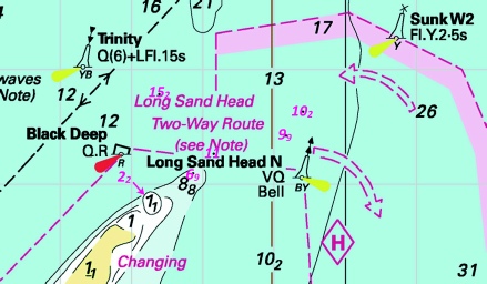
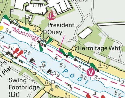
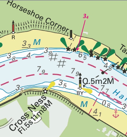
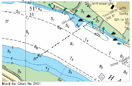
 at
at 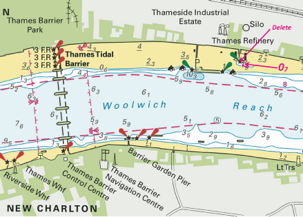
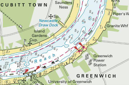
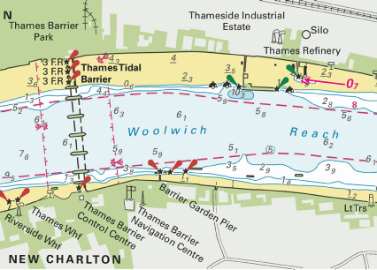
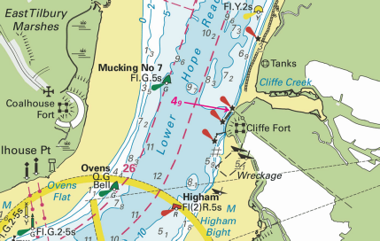
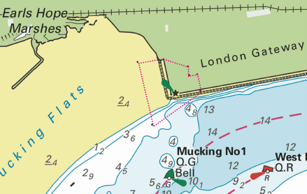
 at 51° 27´·496N., 0° 16´·031E.
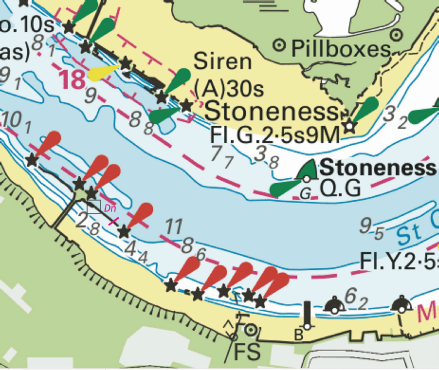
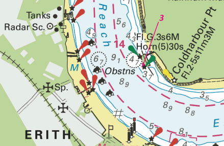
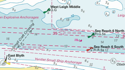
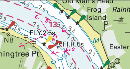


 at 51° 28´·52N., 0° 40´·44E.


 at 51° 29´·42N., 0° 47´·32E.
 at:
at:

 at 51° 23´·65N., 1° 12´·10E.


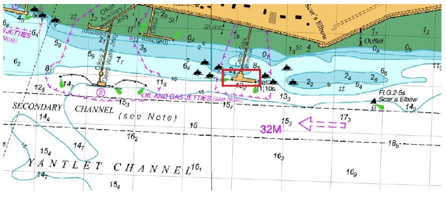
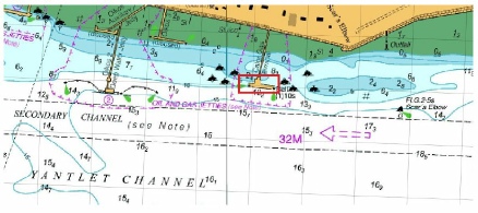


 at 51° 29´·85N., 0° 38´·53E.


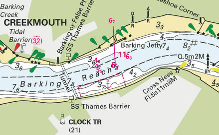
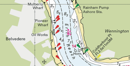
 at 51° 30´·933N., 0° 05´·822E.
 Fl(2)10s Horn(1)20s with
  Fl(2)10s Horn(1)20s at 51° 28´·105N., 0° 14´·701E.
 Q(6)+LFl.15s with
  at 51° 30´·827N., 0° 05´·700E.
 Dn with
  Dn at:
 Siren(2)20s at 51° 30´·404N., 0° 09´·177E., and
 close E.


 Fl.Y.2s (Mar-
 , from: 51° 30´·145N., 0° 00´·822E. to: 51° 30´·085N., 0° 00´·867E.


 at
at


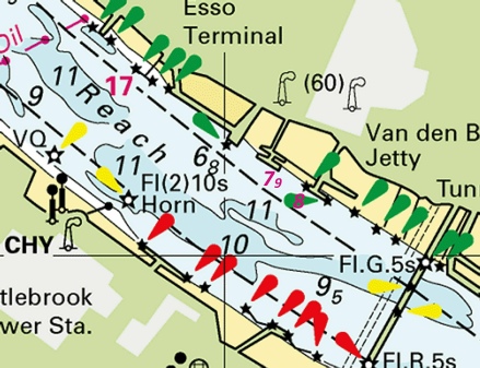
 at 51° 26´·753N., 0° 22´·124E.
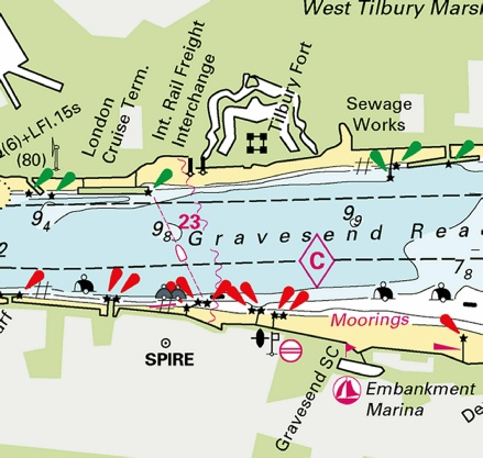
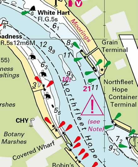
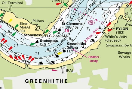
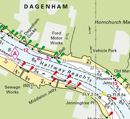
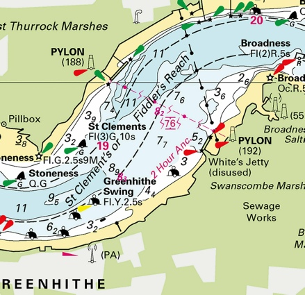
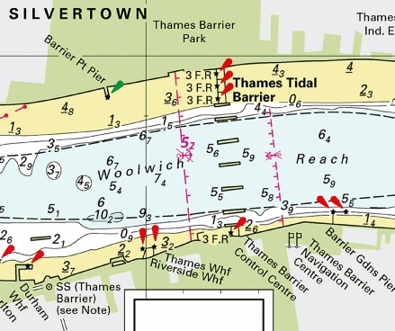
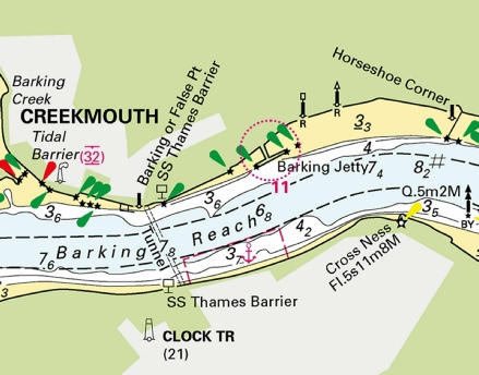
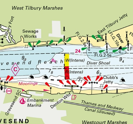
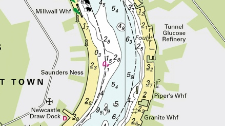
 at 51° 30´·13N., 0° 39´·74E. and 51° 29´·75N., 0° 42´·13E.
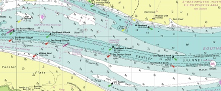
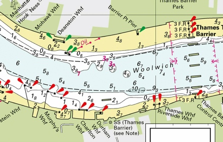
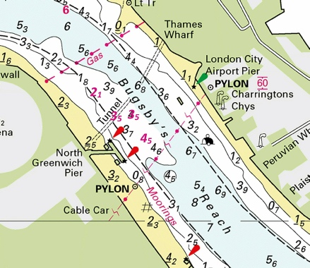
 at 51° 30´·22N., 0° 36´·83E.
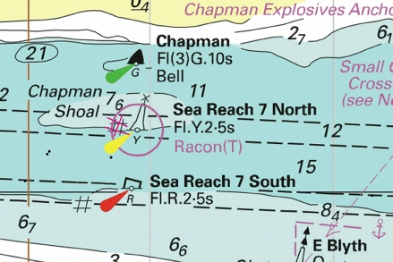
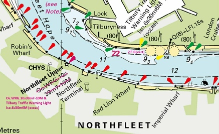
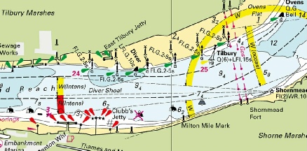
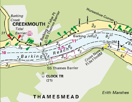
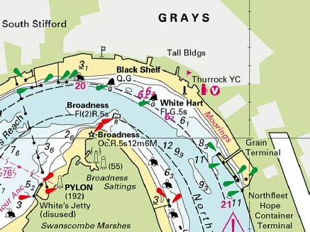
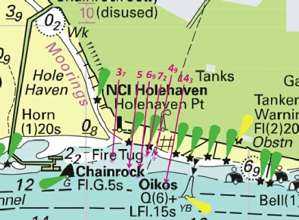
 Q.Y
Q.Y 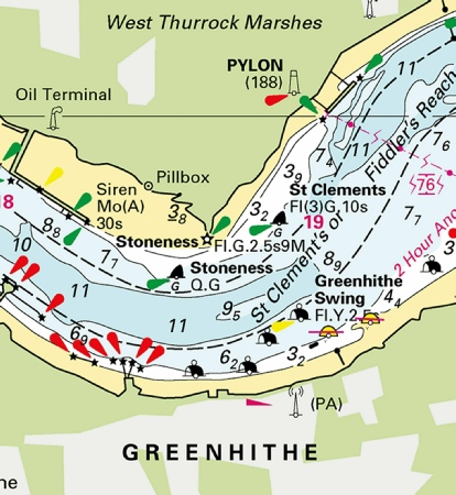
 with
with  at 51° 27´·278N., 0° 16´·833E.
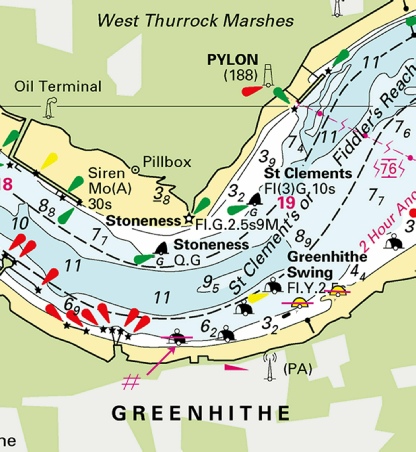
 Pontoon Barge
  Fl.Y.2s
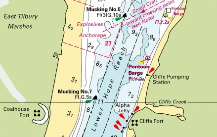

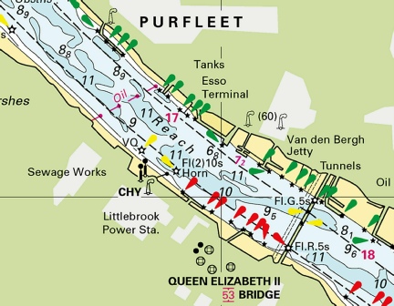
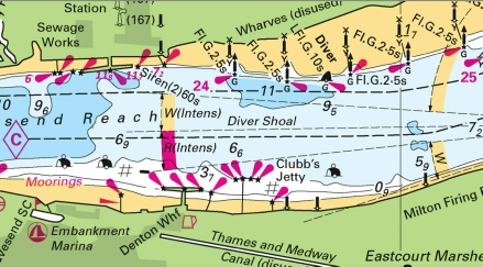
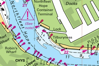
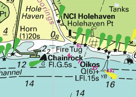
 at 51° 29´·58N., 0° 51´·72E.
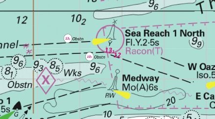
 at:
at: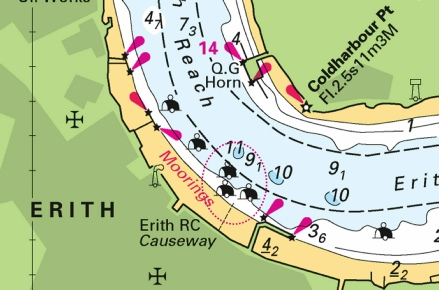
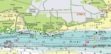
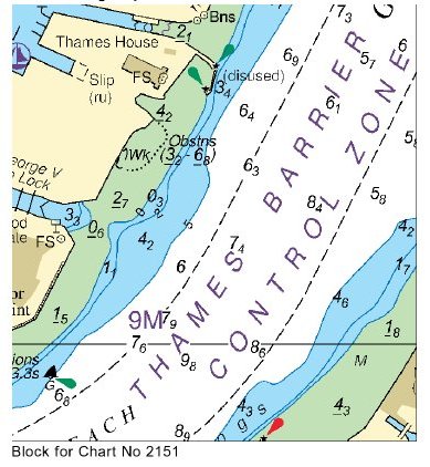
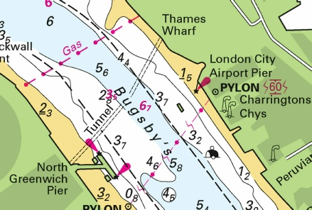
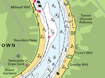
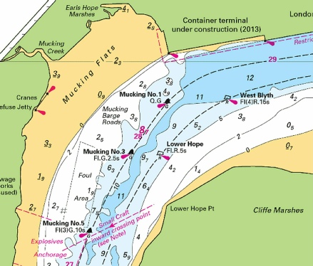
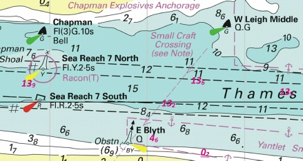
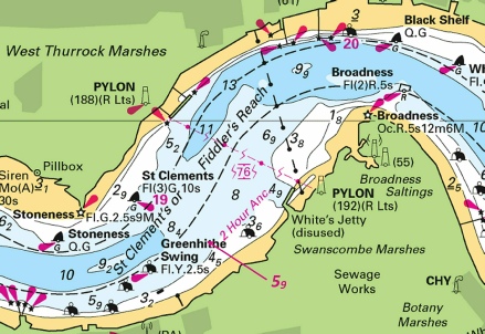
 at 51° 27´·096N., 0° 22´·880E.
 at 51° 27´·093N., 0° 22´·802E.
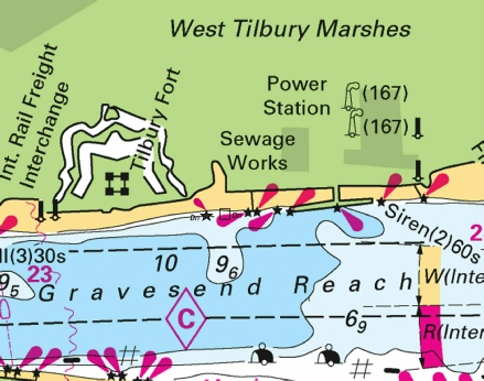
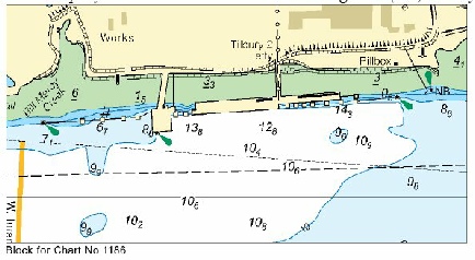
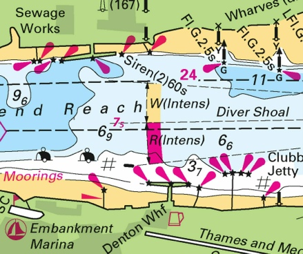
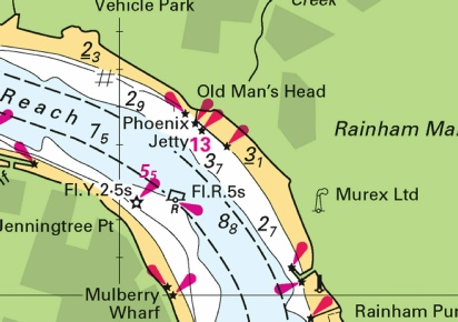
 at 51° 30´·409N., 0° 31´·077E.
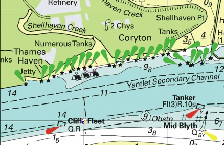
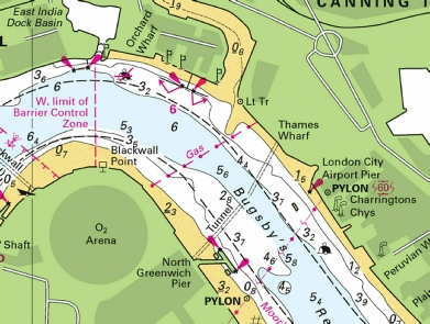
 at
at 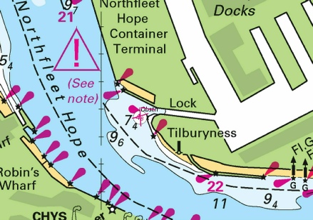
 from: 51° 30´·436N., 0° 00´·421E. to: 51° 30´·453N., 0° 00´·357E.
 at 51° 24´·90N., 1° 26´·20E.
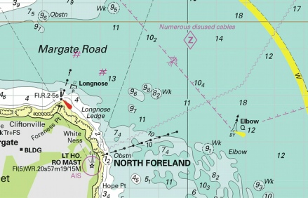
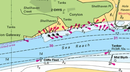
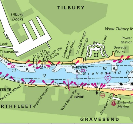
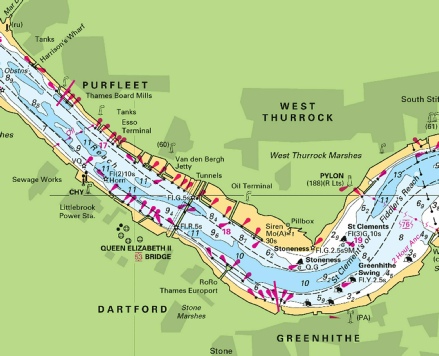
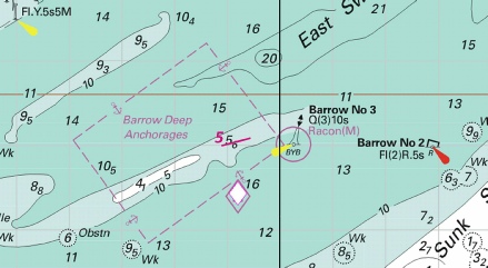
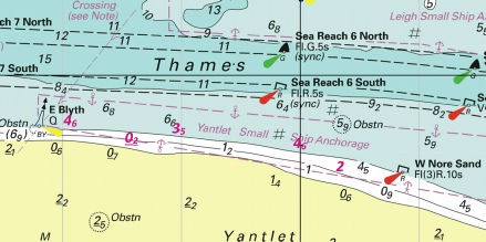

 at 51° 30´·465N., 0° 10´·335E.
 at 51° 30´·453N., 0° 10´·325E.
 at 51° 30´·457N., 0° 10´·321E.
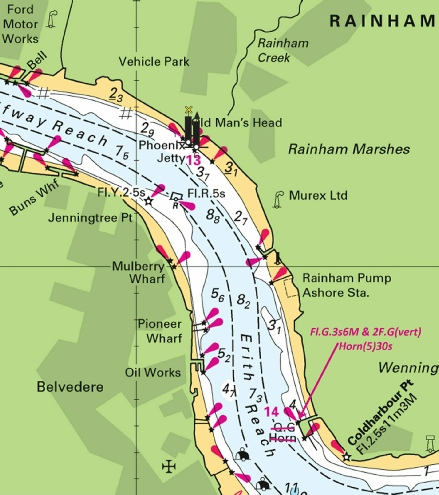
 at 51° 26´·777N., 0° 21´·762E.
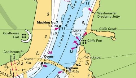
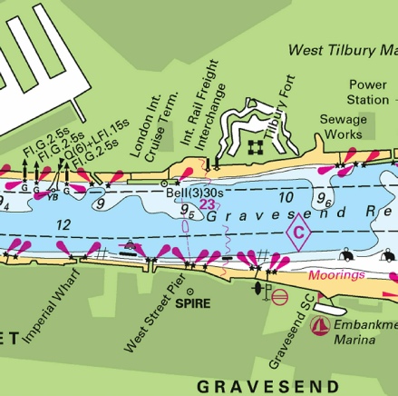
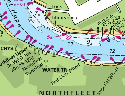
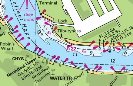
 at 51° 29´·743N., 0° 02´·583E.
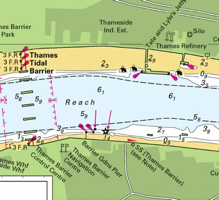
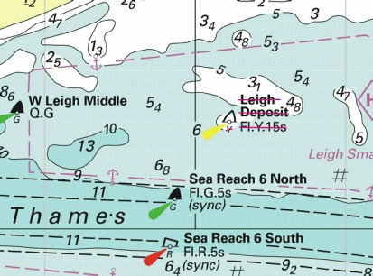
 at 51° 29´·42N., 0° 47´·32E.
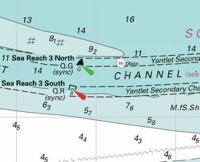
 at 51° 29´·35N., 0° 52´·25E.
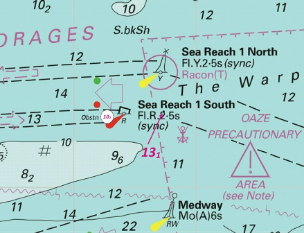
 , joining:
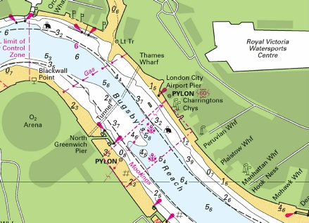
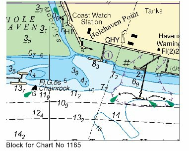
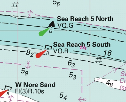
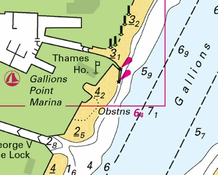
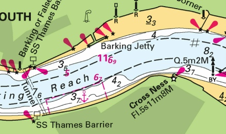
 at 51° 24´·50N., 1° 27´·10E.
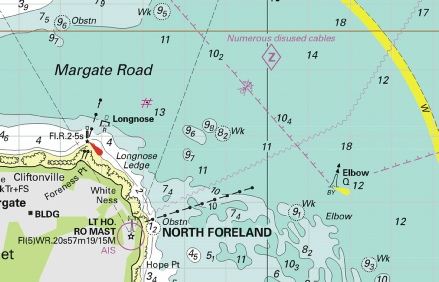
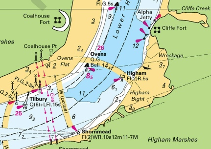

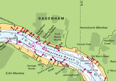

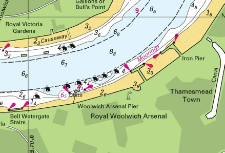
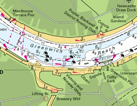
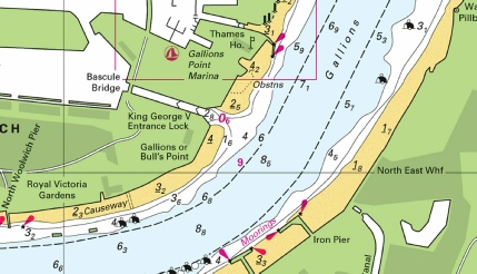
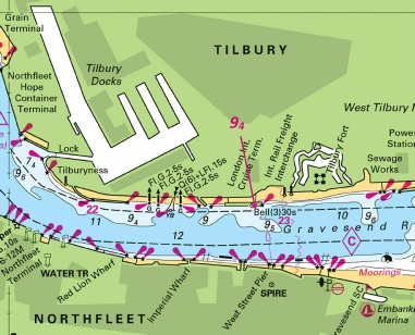
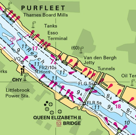
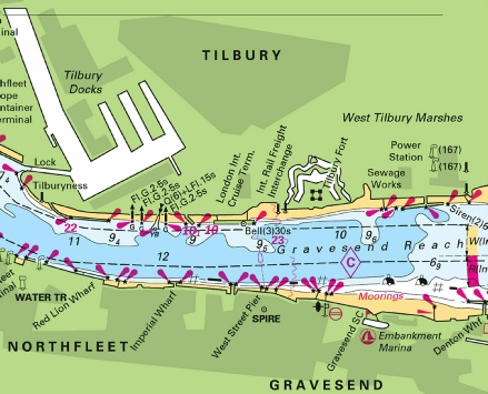
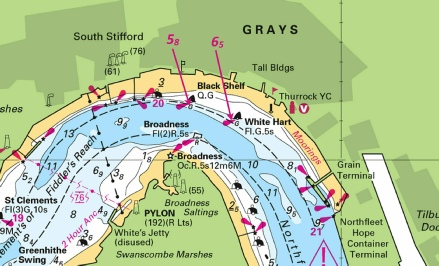
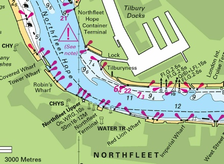

 Q(6)+LFl.15s
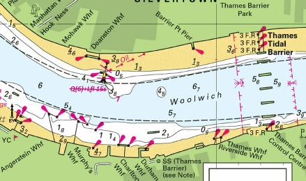
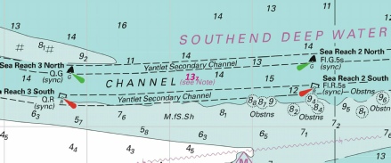
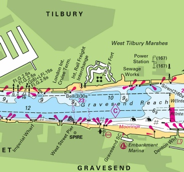
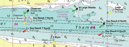

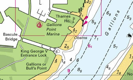
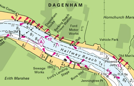
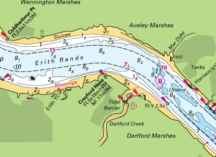
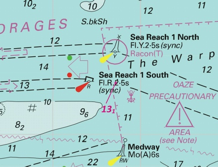
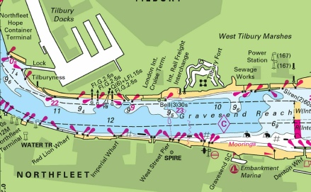
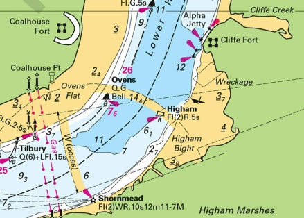
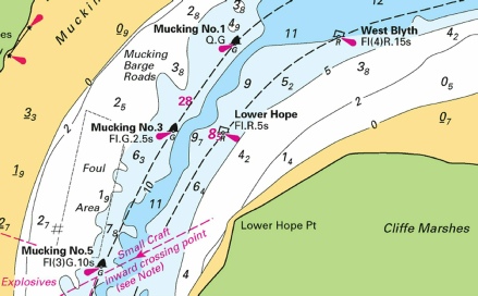
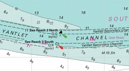
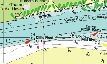
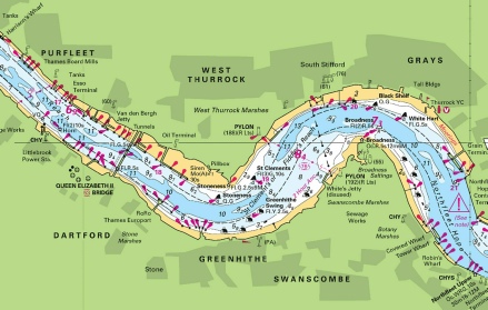
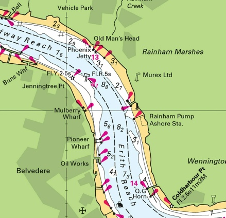
 Wk
Wk  Wk
Wk