|
Local Authority Notices to Mariners |
||
|
Week 44 |
EAST COAST OF ENGLAND - Latitude 52° 19.632’N., Longitude 001° 40.886’E. Amendment: On or about the 21st November 2024, for a period of approximately three days, the main light will have a reduced range of 12nm due to maintenance works taking place. No further notice will be given. |
Trinity House Notice to Mariners, No 223 of 2024 |
|
Week 44 |
Northfleet Hope - On or around 22nd October 2024, Livetts will be undertaking filming activities in Northfleet Hope Reach at the Tilbury Grain Terminal. These activities will involve the vessels “SCHELDEMOND” and “CHILI DOG” and will include, but not be limited to, lifting operations and persons working near the water line. Filming works are expected to take no longer than 5 days and to be undertaken between the hours of 1800 and 0900. The chartlet shows the general location of the works, indicated by the red box. Vessels “BRAVO LIMA” and “ROMEO LIMA” will be in attendance as dedicated safety craft, alongside “THAMES VIXEN”. During these planned operations, any requirement to proceed with caution or at slow speed will be made in accordance with the procedure set out in the Port of London Authority’s Port Information Guide, under ‘London VTS’, ‘Section 4’. All vessels are required to display lights and signals as per the International Regulations for Preventing Collisions at Sea and maintain a listening watch on VHF channel 68. For the latest information, contact London VTS on VHF channel 68 or telephone 01474 562215. |
Port of London Authority Notices to Mariners Nos L66 of 2024
|
|
Week 44 |
Gallions Reach - Mariners are advised that on or about Friday 1st November 2024 contractors for the Royal Docks will commence lifting operations within the King George V Lock. The operations will take place over 10 days. To facilitate these lifting operations, during which the Outer Lock gates will be removed, a pass with caution will be required. The location of the lifting operations is shown on the chartlet. Request for vessels to proceed with caution or pass at slow speed will be made by London VTS on VHF ch.14, in accordance with the Port of London Authority’s Port Information Guide, under ‘London VTS’, section 4. International Code Flags ‘Romeo Yankee (RY)’ will be displayed accordingly. Vessels are requested to be mindful of the nature of the works and of their wash when passing, particularly during lifting operations. Further details will be broadcast by London VTS on VHF Channel 14. |
Port of London Authority Notices to Mariners Nos M73 of 2024
|
|
Week 44 |
Limehouse Reach - Mariners are advised that, on or about Monday 4th November 2024, contractors will commence dredging operations at Hilton Pier, Limehouse Reach. Dredging operations are expected to last for 10 days and will be conducted on ebb tides only. To support these dredging operations, on Monday 14th October 2024 the vessel HUSKIE will conduct survey operations. The general location of the works is indicated by the red area on the chartlet. Dredging operations will be carried out from the vessel ASSASSIN. At times during the operation, any requirements to proceed with caution or at slow speed, will be made in accordance with the procedures set out in the Port of London Authority’s Port Information Guide, under ‘London VTS’, ‘Section 4’ with the International Code Flags ‘Romeo Yankee’ displayed. The display of these signals will be in addition to any other lights or shapes required under local regulations and the International Regulations for Preventing Collisions at Sea. Further details will be broadcast by London VTS on VHF Channel 14. |
Port of London Authority Notices to Mariners Nos M72 of 2024
|
|
Week 44 |
Thames Estuary - Mariners are advised that, on or about 17th October 2024, hydrographic survey operations are expected to commence in the Barrow Deep Channel and other areas in the vicinity. The chartlets show the survey areas bounded by the red lines:. These hydrographic surveys are expected to be complete no later than 15th November and will be carried out by 13m LOA workboat TITAN DISCOVERY,. During the survey operations, vessels are advised to navigate with caution in, and in the vicinity of, the survey areas. Further details will be broadcast, as needed, by London VTS on VHF channel 69.. |
Port of London Authority Notices to Mariners Nos L64 of 2024
|
|
Week 44 |
Thames Estuary - Mariners are advised that on or about Tuesday 22nd October, works to remove the existing ‘Leigh Buoy’ located at the western end of the Southend Small Ships Anchorage will be conducted from London Titan. Exact location of works is depicted by a red box on the chartlet The buoy will be replaced later in the week by a private contractor working on behalf of Southend- 51°31'05.4"N, 000°42'43.9"E An image of the replacement buoy is shown for reference. Further information will be broadcast by London VTS on VHF 69 & VHF 68 as required. |
Port of London Authority Notices to Mariners Nos L63 of 2024
|
|
Week 44 |
Dredging Operations – Shoalway – Update 1 Mariners are advised that Shoalway (IMO: 9556337) will be carrying out trailing suction hopper dredging operations from or around 14 October 2024 for approx. 3 weeks in the following areas: - - -
This local notice to mariners replaces No. 60 of 2024, which is now withdrawn. |
Harwich Haven Authority Notices to Mariners No 64 of 2024 |
|
Week 43 |
Thames Estuary - Mariners are advised that, on or about 11th October 2024, the laying of the Neuconnect cable is expected to commence. The intended route of the Neuconnect cable is indicated on the chartlet. The cable will be laid by vessel CABLE ENTERPRISE (photo below), which is expected to progress along the route at a speed not exceeding 0.06kts. Support vessels, including tugs & workboats, may be operating in the area around CABLE ENTERPRISE while she is working. While engaged in this cable laying operation, CABLE ENTERPRISE will be Restricted in her Ability to Manoeuvre, as she will be tethered to the cable as it is laid. Accordingly, all vessels are required to keep at least 250m clear of CABLE ENTERPRISE at all times. Whenever a vessel, for reasons of safe navigation, is unable to keep at least 250m clear of CABLE ENTERPRISE, that vessel may, subject to permission from London VTS, pass CABLE ENTEPRISE at a closer range, but never less than 100m. Vessels intending to navigate in the vicinity of CABLE ENTERPRISE may be subject to traffic management carried out by London VTS in the interests of safety. Masters / Pilots are advised to contact London VTS in advance of approaching CABLE ENTERPRISE to allow for early coordination and management of traffic movements. All vessels passing CABLE ENTERPRISE or navigating in the vicinity of her works are reminded to be mindful of their wash effects. Whenever cable laying operations are in progress in the Swatchway and vicinity, it may be necessary to temporarily close the Swatchway to navigation of uninvolved vessels, until CABLE ENTERPRISE has progressed sufficiently clear. Any such temporary closures will be broadcast by London VTS. Requirements to proceed with caution or at slow speed during these operations will be made in accordance with the procedures set out in the Port of London Authority’s Port Information Guide, under ‘London VTS’, ‘Section 4’ with the International Code Flags ‘Romeo Yankee’ displayed. The display of these signals will be in addition to any lights or shapes required under local regulations and the International Regulations for Preventing Collisions at Sea. This Notice will remain published until these operations are complete; at that time, it will be withdrawn without further communication. For the latest information, mariners should contact London VTS on VHF channel 69, or telephone 01474 560311. |
Port of London Authority Notices to Mariners Nos L62 of 2024
|
|
Week 43 |
RIVER THAMES - Mariners are advised dredging operations will commence on or around the 9th of August 2024 & will continue until approximately 25th October, 2024. Dredging will take place in the following locations: Sea Reach 3 Vessels being used for this area: Meuse River, Dhamra, MV Elysse, Coastal Surveyor. Latitude (North) Longitude (East) 51° 29' 39.515" 000° 44' 20.671" 51° 29' 30.006" 000° 44' 17.538" 51° 29' 30.637" 000° 50' 44.805" 51° 29' 20.943" 000° 50' 45.655" Knock John Vessels being used for this area: Meuse River, Dhamra, MV Elysse. Latitude (North) Longitude (East) 51° 32' 12.414" 001° 7' 10.481" 51° 32' 07.082" 001° 7' 16.497" 51° 32' 34.531" 001° 8' 5.102" 51° 32' 29.218" 001° 8' 11.078" Sunk Vessels being used for this area: Meuse River, Dhamra, MV Elysse. The Sunk Part 1 Latitude (North) Longitude (East) 51° 48' 48.942" 001° 33' 09.059" 51° 48' 45.691" 001° 33' 23.819" 51° 49' 04.188" 001° 33' 17.594" 51° 49' 01.021" 001° 33' 32.404" The Sunk Part 2 Latitude (North) Longitude (East) 51° 50' 02.612" 001° 33' 50.987" 51° 49' 58.507" 001° 34' 05.189" 51° 50' 26.076" 001° 34' 08.658" 51° 50' 21.970" 001° 34' 22.862" The Sunk Part 3 Latitude (North) Longitude (East) 51° 51' 14.960" 001° 35' 46.227" 51° 51' 05.250" 001° 35' 46.298" 51° 51' 15.238" 001° 37' 30.755" 51° 51' 05.529" 001° 37' 30.820" The material dredged at Berth 4 Approaches will be pumped ashore on LGW Berth 5. All other material will be dumped offshore at South Falls, Inner Gabbard or North Edinburgh Channel. Involved Vessels The vessels involved in this operation are as follows: Meuse River – Trailer Suction Dredger Dhamra – Water Injection Dredger MV Elysse – Survey Vessel Mena C – Crew Transfer Vessel RV Coastal Surveyor – Survey Vessel During the operations, these vessels will maintain a 75- All involved vessels will be keeping a listening watch on VHF Channel 68 and will be in direct contact with the London Gateway Harbour Master and shift managers. mariners are urged to exercise caution and remain vigilant when navigating in the vicinity of dredging works. For more information, please contact London VTS at 01474 562215. |
Port of London Authority Notices to Mariners Nos L65 of 2024
|
|
Week 43 |
Sunken Buxey Lighted Buoy – River Crouch - Mariners are advised that the Sunken Buxey Lighted Buoy in approximate position: 51°39.595 N, 001°00.765 E is now back on station. Lands End Race Mark – River Crouch - Mariners are advised that the Lands End Race Mark in approximate position: 51°38.213 N, 000°46.102E has been permanently removed. |
Crouch Harbour Authority Notices to Mariners Nos 22 and 23 of 2024 |
|
Week 42 |
RIVER THAMES - This Notice supersedes and replaces M5- Mariners are advised of the continuing Tideway Tunnel Project temporary cofferdam deconstruction works at King Edward Memorial Park, near Shadwell Basin, including lifting works from a crane barge and diving operations. Works are expected to continue for approximately 6 months. At times a 500t barge may be moored outside the works area marked on the chart. The chartlet shows the maximum extent at which this barge may be moored (in red). In addition, project barges will be using the site at Chambers Wharf and the Stone Stairs Barge Tier, which is leased for the duration of these works. Works involve excavation, pile removal, dredging and laying of scour protection using divers and a variety of crane barges, supply barges, dredgers, tugs, work boats and multicat vessels. The vessels will maintain a listening watch on VHF channel 14. Crane lifts of heavy piles, and dive works involving use of cutting equipment in low visibility waters, are ongoing during this project and require passing vessels to avoid causing wash, particularly over the high water period when reflection off the river wall can increase the effects. All vessels are reminded of the importance of passing the site at slow speed when the International Code Flags ‘Romeo Yankee (RY)’ are displayed and broadcasts are made by London VTS on VHF ch 14, in accordance with the Port of London Authority’s Port Information Guide, under ‘London VTS’, section 4. PLA Safety Bulletin SB8- Further details will be broadcast by London VTS on VHF Channel 14. |
Port of London Authority Notices to Mariners Nos M69 of 2024
|
|
Week 42 |
Lowestoft Outer Harbour – Royal Norfolk and Suffolk Yacht Club Traffic Lights – non-
Mariners and Port Users are advised that the traffic light system in place at the exit to the Royal Norfolk and Suffolk Yacht Club Marina Basin, are not operational. Mariners wishing to enter or exit the Marina basin, are requested to first obtain permission from Lowestoft Port Control on VHF Ch14. A notice will be issued once the traffic lights have been re- Please contact Lowestoft Port Control, VHF Ch14, Tel. 01502 572286 (Option 3) if further information is required. |
Lowestoft (ABP Ports) Notices to Mariners No 52 of 2024 |
|
Week 42 |
Lowestoft Inner Harbour, Outer Harbour and Approaches – Dredging and Survey Activity Mariners and Port Users are advised that dredging and survey activities are scheduled for Lowestoft Approaches and Inner/Outer Harbour Areas as follows: - Suction Dredger UKD Orca, commencing 4th October – duration of work 7 days, areas of operation: Lowestoft Approaches, Inner and Outer Harbour areas. Working hours 24/7.
Suction Dredger Sospan Dau, commencing 13th October – duration of works 3 days, areas of operation: Lowestoft Approaches and Outer Harbour areas. Working hours 24/7. Plough Dredger MTS Valour, commencing 13th October – duration of works 5 days, areas of operation: Lowestoft Approaches and Outer Harbour areas. Working hours 07:00hrs to 19:00hrs daily.
Grab Dredger UKD Cherry Sand, commencing 20th October – duration of works 8 days, areas of operation: Lowestoft Inner and Outer Harbour areas. Working hours 07:00hrs to 19:00hrs daily.
Plough dredger UKD Seahorse, commencing 26th October – duration of works 9 days. Areas of operation: Lowestoft Inner and Outer Harbour areas. Working hours 07:00hrs to 19:00hrs daily. Dredging Operations will be supported by small survey craft ‘Sea Eagle’ or substitute craft. Surveys will be conducted on an ad- Dredgers will display lights and shapes for dredging activities as prescribed in the International Regulations for Preventing Collisions at Sea. They will maintain a listening watch on VHF Ch 14. Vessel movements will be co-
Mariners are requested to afford dredging and survey activities a wide berth if practical and safe to do so, and to pass at slow speed. Please contact Lowestoft Port Control, VHF Ch14, Tel. 01502 572286 (Option 3) if further information is required. |
Lowestoft (ABP Ports) Notices to Mariners No 51 of 2024 |
|
Week 41 |
River Medway - Notice is hereby given that: a programme of “under- 14th & 15th Oct – Old Ships Passage 16th & 17th Oct – Strood Span 18th Oct: contingency for above locations. 21st and 22nd Oct – Centre Span 23rd and 24th Oct – Rochester Span 25th – Contingency for above The contractor is working in collaboration with Medway Council/Volker to utilise their traffic management for other works and the works will be restricted to daytime hours between 09:30 and 15:30 on the above dates. A safety boat, callsign “Zero” will be on station during inspection periods who will maintain a listening watch on VHF CH. 74 at all times. Bridge spans will be closed to navigation during respective inspection work periods as detailed above and will be specified by a manual closure sign suspended from the bridge. All vessels needing to transit Rochester bridge during this period should do so with caution and check the status of works before proceeding. Admiralty Chart Number 1835 refers. Further information may be obtained from Medway VTS on VHF Channel 74, call sign “Medway VTS” or telephone 0151 949 6148 or 0151 949 6650 (Recorded Lines) |
Medway (Peel Ports) Notices to Mariners No 53 of 2024
|
|
Week 41 |
River Medway – Saltpan Reach - Notice is hereby given that Saltpan No.1 and No.2 mooring buoys have been discontinued, the riser chains for both buoys have been lowered to the seabed and will not be recovered. The UKHO have been informed of the change which will be reflected in future Admiralty Notice to Mariners. Until the respective admiralty charts have been updated to denote the foul area, mariners are advised not to anchor in the vicinity of the mooring buoys currently shown. Admiralty Chart Nos.3683 and 1834 refer. Further information may be obtained from Medway VTS on VHF Channel 74, call sign “Medway VTS” or telephone 0151 949 6148 or 0151 949 6650. (Recorded Lines) |
Medway (Peel Ports) Notices to Mariners No 54 of 2024
|
|
Week 41 |
Rill Clearance works at Foulness Island – 07 Oct to 01 Nov 24 - - - - - - |
Crouch Harbour Authority Notices to Mariners No 19 of 2024
|
|
Week 41 |
London Array Wind Farm - All mariners are advised that the Jack- Jack- Equipment will be periodically deployed and suspended from the vessel crane during jack up operations. A 500m radius restricted zone will be in place, centred on the Ziton Wind Server whilst pinned on location. If access is required to this zone for non- The vessel will be supported by CTV’s Windcat 21, 27, 29, 36, 39 and Spectrum 2 as required during its time on site at London Array. |
London Array wind Farm Notices to Mariners No 16 of 2024 |
|
Week 41 |
Sizewell Harbour - NOTICE IS HEREBY GIVEN That survey operations are planned to resume from 1st October 2024 for approximately 5 weeks. A scan of the seabed will be carried out in the nearshore area to identify items as part of a pre- The work will be carried out from a 12m, white twin hulled survey vessel called VALKYRIE (pictured right) which will operate during daylight hours only. The operation will involve both vessel- During the survey work the vessel will be restricted in her ability to manoeuvre due to the towed equipment. Other vessels should maintain an appropriate and safe distance of 500m when passing the survey vessel whilst it is undertaking survey operations and should pass at the lowest speed possible to avoid vessel wash effects. The survey vessel will maintain a continuous listening watch on VHF Channel 16. The chart shows the planned survey area where operations will be undertaken. Nearshore coordinates A 52° 13.48662' N 1° 37.47983' E B 52° 13.4718' N 1° 37.96196' E C 52° 13.09494' N 1° 37.93118' E D 52° 13.10976' N 1° 37.44911' E |
Sizewell C Notice to Mariners No 6.1 of 2024
|
|
Week 40 |
RIVER THAMES - Mariners are advised that, on or about Monday 23rd September 2024, contractors will commence works on the piles at Masthouse Terrace Pier, including the downstream isolated pile. Works will last for approximately 8 weeks and take place during daylight hours only. The general location of the works is indicated by the red box on the chartlet. Scaffolding will be installed to encompass each of the piles to provide a platform for contractors to carry out the routine maintenance. The scaffolding on either end of the pier will be supported by the berth and will rise and fall with the tide. The Scaffolding on the downstream isolated pile will be fixed. Workboat CHILLI DOG will assist in the installation and demobilisation of the scaffolding and at times a safety boat GUARD DOG will be in attendance. All vessels involved in the works will be maintaining a listening watch on VHF Channel 14. At times during the operation, requirements to proceed with caution or at slow speed, will be made in accordance with the procedures set out in the Port of London Authority’s Port Information Guide, under ‘London VTS’, ‘Section 4’ with the International Code Flags ‘Romeo Yankee’ displayed. The display of these signals will be in addition to any other lights or shapes required under local regulations and the International Regulations for Preventing Collisions at Sea. Further details will be broadcast by London VTS on VHF Channel 14. |
Port of London Authority Notices to Mariners Nos M66 of 2024
|
|
Week 39 |
RIVER THAMES - To ensure safe navigation, mariners are kindly reminded of the importance of practicing good seamanship and exercising utmost caution when executing turns in the river. It is essential that vessels in the proximity of those performing turning manoeuvres also exhibit equal levels of caution and vigilance. A Vessel Turning Any vessel turning is required by Thames Byelaw 25.2 to ensure that the fairway is sufficiently clear for the manoeuvre so as not to endanger or impede any other vessel. Before commencing a turn, or instructing assisting tugs to manoeuvre, the mariner should ensure, by all available means, that there are no vessels which may be adversely affected by their movement. The sound signals prescribed in Thames Byelaw 42 should be used to indicate the vessel’s intentions. A Vessel Passing a Vessel Turning Notwithstanding the above, vessels intending to pass a vessel which is turning or about to turn should navigate with particular caution. They should be aware of the possible space required by a vessel turning, considering wind and tidal conditions. Assisting tugs may be using long tow lines resulting in a far larger swept path. Passing should be carried out at a safe distance and safe speed considering the effects of hydrodynamic interaction, wash and draw off. Traffic Management by London VTS When a reporting vessel is turning off a berth, London VTS may manage traffic. If any vessel wishes to overtake or pass a vessel once its turn has commenced, London VTS may agree that passing can take place in one of the following circumstances: The turn is complete to such an extent that the pilot or PEC holder informs VTS that they permit through traffic under VTS traffic management. The turn is taking place clear of the navigational channel.The passing/overtaking vessel has sufficient room to pass the opposite side of the channel, or in the secondary channel, with permission from London VTS. Any vessel intending to pass a reporting vessel which is turning, or about to turn, should make early contact with London VTS for instructions. |
Port of London Authority Notices to Mariners Nos P9 of 2024 |
|
Week 39 |
THE SWALE – FERRY REACH - Notice is hereby given that: due to scheduled maintenance work, Kingsferry Bridge will be closed to all navigation during October/November 2024. Work to complete the replacement of wire lifting ropes is due to commence 11th October 2024 with completion expected by 3rd November 2024 and will be carried out as per the following schedule. During these periods the Kingsferry Bridge will not be able to lift for any marine traffic. The first closure is to facilitate inspections of the steelwork ahead of the planned 8 day closure in the Kent schools half term week. Any revisions to planned closure dates will be promulgated via an amendment to this notice. KFB Planned Closure Periods (No Bridge Lifts Available) 1930 - 2200 - Admiralty Chart Number 2572 refers. Further information may be obtained from Medway VTS on VHF Channel 74, call sign “Medway VTS” or telephone 0151 949 6148 or 0151 949 6650 (Recorded Lines) or from Kingsferry Bridge on VHF Channel 10. |
Medway (Peel Ports) Notices to Mariners No 47 of 2024 |
|
Week 38 |
RIVER THAMES - Mariners are advised that, on or about Monday 2nd September 2024, unexploded ordnance (UXO) clearance operations in support of the Neuconnect project are expected to commence. These operations will comprise the clearance of the following UXOs: UXO Reference Latitude Longitude NEU_B01_MAG_0610 51° 28’.73 N 000° 44’.63 E NEU_B01_MAG_0610_A 51° 28’.73 N 000° 44’.63 E NEU_B01_MAG_0614 51° 28’.72 N 000° 44’.65 E NEU_B01_MAG_0615 51° 28’.73 N 000° 44’.65 E During a preparation and post- During an active clearance phase, during which high or low order detonation of UXOs may be carried out, a safety zone of up to 0.55nm / ~1,000m will be required around the UXO location. London VTS will notify mariners of the upcoming commencement of an active clearance phase on at least 4 half- No vessel, except a vessel involved in the UXO clearance operations (or, in exceptional circumstances, a vessel with the express prior consent of London VTS) is to enter inside or remain within any of the safety zones described above during the times when they are in force. In connection with these UXO clearance operations, 3 passive acoustic monitors (PAMs) will be deployed in the following positions: Reference Latitude Longitude PAM1 51˚ 28’.82 N 000˚ 45’.50 E PAM5 51˚ 29’.06 N 000˚ 48’.94 E PAM10 51˚ 29’.16 N 000˚ 52’.03 E The PAMs will each be buoyed on the surface by a yellow- The charlet shows the approximate positions of the UXOs to be cleared (red symbols), the PAMs (black symbols) and a general indication of the safety zone to be in force for an active clearance phase (red circle). The following vessels are expected to be operating in the area for these UXO clearance operations: Jack- Tug DUKE OF NORMANDY OSV 4- Cabin RIB THUMPER CURO Additional vessels may be detailed to participate in these operations, in addition or as substitute to those listed above. The involvement of a particular vessel may be confirmed with London VTS as necessary. Any requirements to proceed with caution or at slow speed during these operations will be made in accordance with the procedures set out in the Port of London Authority’s Port Information Guide, under ‘London VTS’, ‘Section 4’ with the International Code Flags ‘Romeo Yankee’, which are illustrated. The display of these signals will be in addition to any lights or shapes required under local regulations and the International Regulations for Preventing Collisions at Sea. This Notice will remain published until the UXO clearance operations are complete; at that time, it will be withdrawn without further communication. For the latest information, mariners should contact London VTS by VHF ch. 68 / 69 or by telephone on 01474 560311. |
Port of London Authority Notices to Mariners Nos L51 of 2024
|
|
Week 38 |
Burnham Town Pontoon - Mariners are advised that installation of the new Maldon District Council owned and operated “Burnham Town Pontoon” at Burnham waterfront is now completed. Approximate position: 1° 37.450 N, 000° 49.110 E The location and dimensions of the pontoon are similar to those of the previous jetty that was damaged beyond repair during adverse weather conditions in 2022. Please note that mooring to the pontoon is STRICTLY PROHIBITED at all times, including on the hammerhead which is to be kept clear as its use is reserved solely for commercially operated vessels via private licence arrangements with Maldon District Council. Any commercial operator wishing permission to use the pontoon should contact Maldon District Council directly: www.maldon.gov.uk. 01621 854477 |
Crouch Harbour Authority Notices to Mariners No 18 of 2024 |
|
Week 38 |
Ramsgate Approach Channel Mariners are advised that the Ramsgate Approach Channel No.3 buoy, (51⁰19.56 N 001⁰26.58 E) is now unlit. |
Port of Ramsgate Notices to Mariners No 19 of 2024 |
|
Week 38 |
Blakeney Harbour South Cardinal Mark - Southern tip of Blakeney Point Light has stopped working. It has been inspected and found to be severely damaged and has several lines of red paint suggesting a collision. A new light unit is on order. Take care when entering the harbour in poor light conditions and ensure vessels stay within the marked channel to maintain distance from the southern tip of Blakeney point marked by the south cardinal mark. A notice will be sent when the light is operational again. Port Lateral no. 10 - North west end of Blakeney Point QFL.R No.10 has been repositioned and replaced with a smaller can shaped marker, currently unnumbered and with the same light sequence. New position is N 52° 58.705’ E 000° 57.447' A notice will be sent when the numbers are refreshed. |
Blakeney Harbour Association dated 3rd September, 2024 |
|
Week 38 |
RIVER COLNE Prohibition to Navigation Inspection of the Colne Barrier Mitre Gate - Bam Nuttall and Huntons Engineering who are working on behalf of the Environment Agency are scheduled to inspect our mitre floodgate of our storm surge barrier this year and to do so, we need to work in the watercourse using floating platforms. The platforms would impact the navigational channel of the Colne Barrier; however, vessels will still be able to transit through the structure. The risk of this can be managed by adding sufficient lighting and beacons to the temporary working equipment to aid river users in avoiding the structure while navigating through the flood barrier. Location of frame assembly 51° 51' 7.63" N 0° 57' 45.78" E |
Environment Agency Notice to Mariners: September 2024 – November 2024
|
|
Week 38 |
Dover Harbour - Diving Operations – Closed Area (Update 4). Mariners are advised Diving Operations will take place in the area as indicated below and will continue until Friday 13th September 2024. The area is closed to all traffic apart from contracted vessels involved in project 3B. Those vessels operating in the area are to keep a good look out and manoeuvre with caution. |
Dover Harbour Board Notices to Mariners No 24 of 2024
|
|
Week 38 |
East Coast – The Wash Ports – River Nene Admiralty Chart 1200, Imray Y9 Buoy move Mariners are advised of the following buoy within the Nene Port area of jurisdiction. New position. - |
Port of Wisbech Authority Notice to Mariners No 08 of 2024
|
|
Week 36 |
The Swale – Faversham Creek - Notice is hereby given that as a result of a recent application, the consent of the Corporation of Trinity House under section 199(2) of the Merchant Shipping Act, 1995 has been given to Peel Ports Medway for the following: • N19950 Downstream Wreck Revenge – Change from beacon to buoy. • N19949 Upstream Wreck Revenge – Change from beacon to buoy. Details of the new buoys are as follows: Aton No /Name : Downstream Wreck Revenge NE Changed from Beacon to Buoy Location description : Positioned NE (downstream) of the wreck. Latitude : 51*19.453’N Longitude : 000*54.482’E Character : Unlit Range : N/A Structure/buoy size : 4ft Can Colour : Red Topmark : N/A Aton No /Name : Downstream Wreck Revenge SW Changed from Beacon to Buoy Location description : Positioned SW (Upstream) of the wreck. Latitude : 51*19.450’N Longitude : 000*54.471’E Character : Unlit Range : N/A Structure/buoy size : 4ft Can Colour : Red Topmark : N/A Admiralty Chart No. 2571 refers. Further information may be obtained from Medway VTS on VHF Channel 74, call sign “Medway VTS” or telephone 0151 949 6148 (Recorded Line). |
Medway (Peel Ports) Notices to Mariners No 42 of 2024 This wreck is situated in Faversham Creek off the Sewage Works and the wreck is marked on UKHO and Imray charts. |
|
Week 36 |
Approaches to Sheerness – Grain Spit - Notice is hereby given that as part of the ongoing Neuconnect Interconnector project a programme of cable laying operations is due to commence on Grain Spit and across the Swatchway as shown in a detailed notice that can be downloaded. Work is due to commence on or around 31st August 2024 with completion provisionally expected by 30th September 2024. |
Medway (Peel Ports) Notices to Mariners No 43 of 2024
|
|
Week 36 |
RIVER CROUCH - NAVIGATION Mariners are advised that Whitaker No 2 Lighted Buoy in approximate position: 51°40.250 N, 001°05.400 E is currently unlit. |
Crouch Harbour Authority Notices to Mariners No 17 of 2024 |
|
Week 36 |
RIVER COLNE - Maintenance and Repair of the Fieldgate Quay Wall - Henderson & Taylor who are working on behalf of Colchester City Council are scheduled to begin works on vital repair work to the collapsing quayside wall at Fieldgate Quay in Colchester on the 28th of August. Works will involve excavation of the currently collapsed Quayside followed by Piling and Sheet Piling works to construct the replacement quayside wall. A temporary sheet pile wall will be used to cordon off the construction area from the river. This Temporary sheet pile wall will not protrude into the river beyond the point of the original placement of the quayside. Site Location Coordinates. 51°52.4542'N , 00°56.2141'E (DMS) 51.874237 , 0.93690167 (DD) 602266 , 223595 (XY) TM 02266 23595 (OS GRID REF) |
Notice to Mariners: 28th August – 19th November 2024 These repairs are on the west side of the River Colne on the approaches to the Hythe |
|
Week 36 |
Dover Harbour - Mariners are advised that the green navigation light on the Eastern Entrance (FI G 5s 12m 5M) is currently unlit |
Dover Harbour Board Notices to Mariners No 25 of 2024
|
|
Week 36 |
London Array Offshore Wind Farm (Outer Thames Estuary) - All mariners are advised that the Jack- Jack- Jack- Equipment will be periodically deployed and suspended from the vessel crane during jack up operations. A 500m radius restricted zone will be in place, centred on the Ziton Wind whilst pinned on location. If access is required to this zone for non- |
London Array Offshore Wind Farm Notices to Mariners No 15 of 2024 Call up on Ch 16 any LAL vessel for advice about access
|
|
Week 35 |
Lowestoft Inner Harbour – Gull Wing Bridge Harbour Directions
This notice is to provide formal notification that the Gull Wing (Lake Lothing Third Crossing) Harbour Directions will come into effect when the Gull Wing Bridge becomes fully operational. This date is currently scheduled to be 5th September 2024 and is subject to variation due to final commissioning works. A confirmed date will be advised by a follow up Notice to Mariners once it is known. The Harbour Directions, and Bridge scheme of Operation can be viewed @ https://www.abports.co.uk/locations/lowestoft/ or via the Download button |
Lowestoft (ABP Ports) Notices to Mariners No 39 of 2024
|
|
Week 34 |
RIVER THAMES - Following recent incidents involving vessels not taking appropriate action when passing speed reductions, specifically at King Edward Memorial Park, the PLA has identified a requirement to publish further guidance on adherence to speed reductions. Mariners are reminded of their obligations to reduce speed and wash, such as to be appropriate for the activities taking place, when a speed reduction is in force. While this guidance is framed for King Edward Memorial Park, it applies to all speed reductions on the tidal Thames. What is a speed reduction? “Speed Reduction” means a notification from London VTS that vessels must proceed at reduced speed through areas where activities sensitive to the effects of wash or draw- As a guide, speed reductions are used for hazardous activities such as diving, salvage, heavy lifting, working on the waterline from scaffolding or pontoon/small boat, and bunkering operations. Signals for Speed Reduction Notification Mariners will be notified of speed reductions by: 1. Romeo Yankee flags. The site, vessel or installation will display the international code flags “Romeo Yankee” by day and illuminated rigid replica by night. 2. VTS broadcasts. The speed reduction details, including location and activity requiring the speed reduction, will be identified in the half hourly navigational broadcast. Masters considerations in a Speed Reduction The Master must judge the speed appropriate to the circumstances, based upon the activity identified in the broadcast. Reduce speed in good time. Fully consider the vessels wash and draw off, especially when accelerating/decelerating. Remember the exact location of works within the site may not be visible, such as in the case of diving. Remain at appropriate speed until finally past and clear. King Edward Memorial Park King Edward Memorial Park is a Thames Tideway Tunnel works, where a number of hazardous activities have been and continue to take place; these predominantly include diving and heavy lifting. These activities may be taking place in any location across the works site when a speed reduction is broadcast. For this reason, regular speed reductions have and continue to be broadcast. Following an increase of substantiated complaints against vessels transiting this area, when a speed reduction is broadcast by London VTS and Romeo Yankee flags flown, Masters must reduce speed to such that they will not endanger the works through dangerous wash. As works may be taking place in any one or multiple locations across the site Masters should consider speed reductions in this area to apply across the area , and maintain a steady speed, as shown in the chartlet. Masters of high- Failure to comply with a speed reduction As speed reductions are granted to ensure the safe execution of hazardous activities any failure to comply may result in property damage, pollution, or even serious injury or death. For this reason, failure to reduce to an appropriate speed in good time and remain at such speed until finally past and clear will be taken seriously by the PLA. All incidents will be investigated and where noncompliance with the speed reduction is found, enforcement action will be taken. |
Port of London Authority Safety Bulletin Nos SB8 of 2024
|
|
Week 34 |
Surveyed Depths – Harwich Harbour – Update 5 Mariners are advised that recent surveys have identified reduced depths in Harwich Harbour. The controlling depth for deep draught vessels navigating within the harbour area should currently be taken as 15.5m below chart datum, plus height of tide. The minimum depths (below chart datum) are: • 14.9m - • 14.9m - • 15.0m - See survey chart extracts below for further information. Use the Download button This notice replaces local notice to mariners No. 40 of 2024, which is now withdrawn. For further information contact the Harbour Master Team at Harwich Haven Authority (+44 1255 243030). |
Harwich Haven Authority Notices to Mariners No 47 of 2024
|
|
Week 34 |
Dover Harbour - Mariners are advised that the top red light on the two fixed red navigation lights (2F.R) on the Inner Wave Screen Wall is extinguished. Currently there is only one fixed red light. |
Dover Harbour Board Notices to Mariners No 18 of 2024
|
|
Week 33 |
RIVER THAMES - Mariners are advised that from 19th August 2024 and for a period of approximately four months the Tideway Tunnel Combined Sewer Outfall (CSO) at the King Edward Memorial Park site will be diverted to the river. During this period the CSO may discharge rain- The approximate location of the CSO on the King Edward site is shown in red on the chartlet. A set of warning lights will be mounted vertically in front of a black backboard on the cofferdam above the CSO. The lights will flash a yellow alternating 1 second pattern, visible day and night from 045° to 315° at a range of up to 200m, whenever the CSO is discharging or likely to discharge. Tideway advise the lights will activate approximately 8 minutes before any discharge will occur. A broadcast will be made by London VTS on VHF Ch 14 and a Navigation Warning will be issued to those registered to receive Notice to Mariners and displayed prominently on the PLA website when Tideway advise that the CSO is discharging or is likely to discharge shortly. Routine VTS broadcasts will also include a warning if Tideway inform us there is a likelihood there will be a discharge within the next hour from the site. Human powered recreational craft, lower powered vessels and craft engaged in towing are advised to avoid the area over the slack water period (around two hours over low water and an hour over high water) if there has been heavy rain or if there is a Met Office Amber or Red weather warning for rain or storms in force for the London area. After this four- All mariners are advised to exercise caution when passing the site, remain outside of the works area (marked in purple on the chart) and to pay attention to warnings given.. |
Port of London Authority Notices to Mariners Nos M57 of 2024
|
|
Week 33 |
RIVER THAMES - The Thames Flood Barrier will be closed once a month for test purposes, in accordance with a programme issued for a period of six months, commencing 07 November 2024. Listed below are the times between which the Thames Barrier will be closed to navigation for test purposes. During these periods’ navigation in the Thames Barrier Control Zone, between Margaretness and Blackwall Point, will be restricted and any movements in this area will require permission from London VTS. PROGRAMME OF CLOSURES* November Thursday 7th 09:30 to 12:00 December Thursday 19th 09:20 to 11:50 January Monday 20th 10:30 to 13:00 February Monday 17th 09:30 to 12:00 March Thursday 20th 09:40 to 12:10 April Thursday 17th 09:45 to 12:15 *All times are approximate. The closures will be confirmed and promulgated by London VTS from 24 hours in advance of the operation by VHF radio on routine river broadcasts. From the start of each closing procedure until completion of the opening procedure vessels will be prohibited from transiting the Thames Barrier. Most closures are for approximately 2½ hours over the respective low waters. No vessel is to pass Margaretness inward bound or Blackwall Point outward bound once a Thames Barrier closure has commenced unless authorised by London VTS. GATE CLOSURES In addition to the full Thames Barrier closures there will be frequent closures of individual gates for maintenance and training purposes, subject to a programme issued by the Environment Agency. The closure of individual gates will change the spans available for navigation. Information regarding these gate closures will be promulgated by London VTS on VHF Channel 14 routine river broadcasts. A copy of the six- Environment Agency, Thames Barrier Eastmoor Street London SE7 8LX. During each full Thames Barrier or individual gate closure(s), illuminated red crosses will be displayed on both sides of the gate(s) indicating that the gate(s) are closed to navigation: |
Port of London Authority Notices to Mariners Nos P7 of 2024 NOTES: 1. ANY ADDITIONAL THAMES BARRIER CLOSURES FOR TEST PURPOSES WILL BE PROMULGATED BY SEPARATE NOTICES TO MARINERS ISSUED 28 DAYS IN ADVANCE OF SUCH CLOSURES. 2. THE BARKING BARRIER WILL BE CLOSED AT THE SAME TIME AS THE THAMES BARRIER. |
|
Week 32 |
River Thames - Mariners are advised that the Tower Driftwood (PLA) Moorings in the vicinity of Downing’s Roads as depicted on the chartlet are currently not clearly visible, especially around high water. Mariners navigating in the vicinity of these moorings are advised to maintain a sharp lookout and pass well clear. |
Port of London Authority Notices to Mariners Nos M55 of 2024
|
|
Week 32 |
River Stour & Harwich Haven Weather Stations – Update 1 Mariners are advised that Harwich Haven Authority is making the following changes to the local live weather stations (data published on www.hha.co.uk - Sensor No. 4 - maintenance work and the height will be adjusted to 11m above ground level / 15m above chart datum. Sensor No. 2 - having been successfully replaced by new Sensor No.7 at Erwarton Beacon. Additionally, in the week commencing 1 July 2024, the Harwich wind gauge on Navigation House will be relocated from the roof of the building to the knuckle of the Harbour Master’s Pier. This is to avoid building updraft effects and improve the reading quality. |
Harwich Haven Authority Notices to Mariners No 36 of 2024
|
|
Week 32 |
River Medway – Upnor Reach. - Notice is hereby given that work to construct a new jetty at the Royal Engineers Boat School will be commencing shortly. The programme of work will involve piling, construction of a new jetty and installation of a new pontoon which will be located to the south of the existing structure. Once complete, the current jetty will be decommissioned and removed. Work is due to commence on or around 1st August 2024 with completion expected approximately six months later. The crane barge JML50 will be towed to Upnor 30th July 2024 and will be on site for the duration of the work. Please see diagrams below which show the location and design of the planned jetty replacement. All craft passing the Royal Engineers jetty at Upnor should do so with caution, reducing their speed and wash accordingly. Admiralty Chart No. 1835 refers. Further information may be obtained from Medway VTS on VHF Channel 74, call sign “Medway VTS” or telephone 0151 949 6148 (Recorded Line).
|
Medway (Peel Ports) Notices to Mariners No 37 of 2024
|
|
Week 31 |
RIVER THAMES - Mariners are advised that unexploded ordnance (UXO) has been discovered in the following positions: - Latitude 51˚ 28’.72 N Longitude 000˚ 56’.41 E Latitude 51˚ 28’.71 N Longitude 000˚ 56’.60 E In the interests of safety, vessels are advised to keep at least 100m clear of the above positions at all times. Vessels are particularly cautioned against anchoring, trawling or otherwise interacting with the seabed in the vicinity of the above position. The chartlet below shows the general area, with the recommended 100m safety zones around the UXO positions shown by the red circles: - Further information will be broadcast, as necessary, by London VTS on VHF channel 69. This Notice will remain published until such time as the information above is considered sufficiently promulgated or has been promulgated by other means; this Notice may then be withdrawn without further communication. |
Port of London Authority Notices to Mariners Nos L41of 2024
|
|
Week 30 |
RIVER THAMES - Mariners are advised that unexploded ordnance (UXO) has been discovered in the following position: - Latitude 51˚ 28’.80 N Longitude 000˚ 55’.11 E In the interests of safety, vessels are advised to keep at least 100m clear of the above position at all times. Vessels are particularly cautioned against anchoring, trawling or otherwise interacting with the seabed in the vicinity of the above position. The chartlet below shows the general area, with the recommended 100m safety radius around the UXO position shown by the red circle: - Further information will be broadcast, as necessary, by London VTS on VHF channel 69. This Notice will remain published until such time as the information above is considered sufficiently promulgated or has been promulgated by other means; this Notice may then be withdrawn without further communication. |
Port of London Authority Notices to Mariners Nos L39 of 2024
|
|
Week 30 |
Lowestoft Southern Approaches – Confirmed Report of Drifting Fishing Gear
Mariners and port users are advised that a sighting of drifting fishing gear – nets/lines and 4 x floats, has been confirmed in the vicinity of the Newcombe Sand Buoy, at the Southern entrance to the Stanford Channel. Last confirmed sighting of the fishing gear was at 1700hrs, in approx. position 52˚ 26.2’N, 01˚ 47.5’N. The nets are weighted but are not anchored in position, so will drift with sea/wind/tidal influence. The fishing gear represents a navigational hazard to vessels transiting this area. Mariners are requested to navigate with caution in this vicinity, and to maintain a good lookout. Please report any sightings of the gear to Lowestoft Port Control on VHF Ch14. Fishermen with gear in this vicinity are requested to check that their nets/lines are accounted for, and to report to Lowestoft Port Control if the gear is believed to be theirs, or to report if it has been recovered. Please contact Lowestoft Port Control, VHF Ch14, Tel. 01502 572286 (Option 3) if further information is required. |
Lowestoft (ABP Ports) Notices to Mariners No 33 of 2024 Approx area of fishing gear
|
|
Week 29 |
Blakeney Harbour Association have made SEVERAL changes to the Aids to Navigation in Blakeney Harbour. **** SOUTH CARDINAL **** A South Cardinal Marker has been installed at the southern tip of Blakeney Point. It is imperative that all vessels keep south of the Cardinal marker because the submerged section of the point is incredibly shallow. The coordinates for the South Cardinal Marker are: 52°58.091'N 0°57.477’E. The light sequence for the South Cardinal Marker is: Q(6) + LFL 15s. **** CHANNEL AROUND POINT **** The main channel has moved south of the point around the old mussel beds. This table lists the lateral marker positions that have changed. This Google Maps image of the tip of Blakeney Point demonstrates the new channel location and the South Cardinal Marker position. **** OUTER HARBOUR LATERAL MARKERS**** The Lateral Markers have been relocated according to changes to the channel. This work is still under way and a further update will be sent as soon as there is suitable weather to continue to relocate the lateral markers. No. 9 Starboard Green spar mark. Light sequence Fl.G(2.5s) has moved North west to: 52°58.822'N 0°57.538'E No. 11 Starboard small cone mark. No light has moved North to: 52°58.732'N 0°57.419'E KEEP TO THE STARBOARD SIDE OF THE CHANNEL BETWEEN MARKERS 9 AND 11 UNITIL FURTHER NOTICE No 10 still needs to be moved north west away from the west end of the point, this will be carried out ASAP weather permitting. No.10 Port spar marker. Light sequence QFL.R Creates a gate with no. 9. Current lat and long: 52° 58.732’ N 000° 57.552’ E DO NOT PASS CLOSE TO NO.10 UNTIL FURTHER NOTICE No. 3 Starboard needs to be moves south due to a sand bank forming between no. 1 and no. 3. This will be carried out ASAP weather permitting. DO NOT PASS CLOSE TO NO.3 UNTIL FURTHER NOTICE No.3 Starboard spar mark. Light sequence Fl.G(2.5s) Current Lat and Long: 52° 58.841’ N 000° 58.106’ E |
Blakeney Harbour Association Notice dated 2nd July, 2024 |
|
Week 28 |
RIVER THAMES - Mariners are advised that, on or about Monday 1st July 2024, the Mid- Latitude 51˚ 28’.87 N Longitude 000˚ 43’.32 E This is being carried out to facilitate the progress of the NeuConnect electricity cable project and will be performed by PLA Marine Services vessels and personnel. The chartlet shows the general area, with the current charted position of the Mid- Vessels should continue to report to VTS, as required, at the charted Reporting Point. The Mid- During the buoy relocation works, requirements to proceed with caution or at slow speed will be made in accordance with the procedures set out in the Port of London Authority’s Port Information Guide, under ‘London VTS’, ‘Section 4’ with the International Code Flags ‘Romeo Yankee’. The display of these signals will be in addition to any lights or shapes required under local regulations and the International Regulations for Preventing Collisions at Sea. Further details will be broadcast as appropriate by London VTS on VHF channel 68. |
Port of London Authority Notices to Mariners Nos L38 of 2024
|
|
Week 28 |
Surveyed Depths – Harwich Harbour – Update 3 Mariners are advised that recent surveys have identified reduced depths in Harwich Harbour. The minimum depths (below chart datum) are: • 15.2m - • 15.9m - See survey chart extracts opposite for further information. This notice replaces local notice to mariners No. 31 of 2024, which is now withdrawn. For further information contact the Harbour Master Team at Harwich Haven Authority (+44 1255 243030). |
Harwich Haven Authority Notices to Mariners No 37 of 2024
|
|
Week 28 |
PORT OF GREAT YARMOUTH - MARINERS ARE HEREBY ADVISED that Norfolk County Council will be undertaking maintenance works on Haven Bridge between 08:00 hours and 15:00 hours, from Tuesday 18th June 2024, and every Tuesday thereafter, until further notice. Norfolk County Council confirm that the bridge will be non- Mariners are reminded to maintain a listening watch on VHF Channel 12 at all times whilst within the Port of Great Yarmouth and to advise ‘Yarmouth Radio’ of their intention to conduct any manoeuvre within the Port prior to doing so. For further information please contact Great Yarmouth LPS on VHF Channel 12 (callsign ‘Yarmouth Radio’) or 01493 335511. For further information please use contact details below: General enquiries: 0344 800 8020 Website: www.norfolk.gov.uk |
Great Yarmouth (Peel Ports) Notices to Mariners No 33 of 2024 |
|
Week 27 |
Unexploded Ordnance Mariners are advised that unexploded ordnance (UXO) has been discovered in the following position: Latitude 51˚ 30’.11 N Longitude 001˚ 02’.41 E In the interests of safety, vessels are advised to keep at least 100m clear of the above position at all times. Vessels are particularly cautioned against anchoring, trawling or otherwise interacting with the seabed in the vicinity of the above position. The chartlet shows the general area, with the recommended 100m safety radius around the UXO position shown by the red circle: When considered necessary, London VTS will manage traffic to support safe navigation in the vicinity of the UXO and associated safety zone. Further information will be broadcast, as necessary, by London VTS on VHF channel 69. This Notice will remain published until such time as the information above is considered sufficiently promulgated or has been promulgated by other means; this Notice may then be withdrawn without further communication. |
Port of London Authority Notices to Mariners Nos L34 of 2024
|
|
Week 25 |
River Thames - L33 This Notice to Mariners (L29) replaces Navigation Warning issued 08/06/24 at 21:41. Mariners are advised, unexploded ordnance (UXO) has been discovered in the following position: Latitude 51˚ 28.733’ N Longitude 000˚ 44.656’ E L29 Mariners are advised that unexploded ordnance (UXO) has been discovered in the following position: Latitude 51˚ 28’.72 N Longitude 000˚ 44’.65 E L28 Mariners are advised that unexploded ordnance (UXO) has been discovered in the following position: Latitude 51˚ 28’.72 N Longitude 000˚ 44’.60 E L25 Mariners are advised that unexploded ordnance (UXO) has been discovered in the following position: Latitude 51˚ 29’.01 N Longitude 000˚ 49’.20 E In the interests of safety, vessels are advised to keep at least 50m clear of the above position at all times. Vessels are particularly cautioned against anchoring, trawling or otherwise interacting with the seabed in the vicinity of the above position. The chartlets shows the general area, with the recommended 50m safety radius around the UXO position shown by the red circle: |
Port of London Authority Notices to Mariners Nos L33, L29, L28 and L25 of 2024 L33
L29
L28
L25
|
|
Week 25 |
Latest Survey Depths - Mariners are advised that the latest hydrographic survey (04 June 2024) for the River Stour has identified a minimum depth of 0.6m below chart datum. See survey chart extracts (download) for further details. This notice replaces 27- |
Harwich Haven Authority Notices to Mariners No 33 of 2024
|
|
Week 25 |
Sheerness Harbour – No.2 Berth - Notice is hereby given that a programme of work to reinforce existing structural piles underneath Sheerness No.2 berth will getting underway shortly. Work to install pile reinforcement collars is due to commence on or around 10th June 2024 with completion expected by mid- Scaffolding will be fixed to the underside of berth 2 to allow contractor access to the piles in the approximate area highlighted below for strengthening. The works team will be operating between 06:00 and 22:00 on a daily basis but will work to a set tidal window ie. up to 4.2m HoT on the flood tide and from 4.2m HoT down to low water. Contractors will be in daily communication with one of the following: port vessels team, Marine Management Team or Medway VTS who will brief them with details of movements on and off of Sheerness No.2 berth. Work’s staff will vacate the area under the berth during the arrival and departure of ships, when ships are either alongside and shut down or have safely departed the crew will restart operations underneath the quay. At certain stages of the work small boats will be utilised to deliver steel collar sections to the team under the berth, the collars will then be winched up into position prior to installation. Admiralty Chart No. 3683 refers. All vessels transiting Sheerness Harbour should be aware that men will be working under the berth, close to water line and conducting hazardous lifting operations. All vessels should navigate at a safe distance from No.2 berth, reducing wash appropriately. Further information may be obtained from Medway VTS on VHF Channel 74, call sign “Medway VTS” or telephone 0151 949 6148 (Recorded Line). |
Medway (Peel Ports) Notices to Mariners No 31 of 2024
|
|
Week 25 |
MV Reimerswaal – Ipswich Power Station Berth
Mariners are advised of a new vessel arriving into the Port of Ipswich. The MV Reimerswaal will be berthing off of Ipswich Power Station berth. The vessel will berth across the main channel during discharge operations for approximately 2 hours. During the discharge the port will be closed for commercial movements. Leisure craft are requested to pass well clear. The commercial river traffic will be managed by ONS, mariners requiring more information can do so by contacting: - |
Ipswich (ABP Ports) Notices to Mariners No 19 of 2024
|
|
Week 23 |
Harwich Haven - Mariners are advised that hydrographic surveys have identified reduced depths in the Harwich Deep Water Channel. The minimum available depth of water on the centreline is approx. 15.6m below chart datum, with shallower sections towards the channel edges (as per survey data). This local notice to mariners is cumulative and replaces notice 08- |
Harwich Haven Authority Notices to Mariners No 29 of 2024
|
|
Week 23 |
River Medway – Saltpan Reach - Notice is hereby given that a programme of maintenance work is due to take place at Isle of Grain LNG Jetty 10. Work is expected to commence on Monday 3rd June 2024 and is expected to run for a period of 4 – 5 months. The 1st phase of maintenance will be carried out Monday- All vessels passing Grain LNG Jetty 10 should navigate with caution, observe the LNG Jetty exclusion zone at all times and reduce speed and wash accordingly. Admiralty Chart No.1834 refers. Further information may be obtained from Medway VTS on VHF Channel 74, call sign “Medway VTS” or telephone 0151 949 6148 or 0151 949 6650. (Recorded Lines) |
Medway (Peel Ports) Notices to Mariners No 30 of 2024
|
|
Week 23 |
RIVER CROUCH - COURTEOUS NAVIGATION Mariners are reminded of their duty to not only abide by the 8- • Moored craft. • Vessels with tenders alongside. • Small vulnerable craft. Please also consider and keep to a minimum your wake and wash when passing: • Through Burnham Fairway. • Essex Marina. • North Fambridge swing moorings. • All areas upriver of Brandy Hole. • Paglesham swing moorings – River Roach. Ministry of Defence (MOD) Shoeburyness: Range Sea Danger Area SAFETY We have been asked to publish the following safety information from QinetiQ for mariners to be aware of: With the summer months just around the corner, it’s timely to remind local sailing and watersports clubs of the restrictions in the vicinity of the Foulness and Maplin Sands. QinetiQ operates the live weapons test and evaluation Range in Shoeburyness and on Foulness Island in Essex, known as MOD Shoeburyness. The Range is active Monday to Friday (occasionally at weekends), all year round, conducting activities that involve firing and detonating live ammunition, often over long distances, out to sea. To enable the Range to work safely and ensure that hazardous activities do not present a risk to members of the public, it operates under the jurisdiction of the Artillery Ranges Byelaws 1936 and the Shoeburyness and District Military Lands Byelaws 1935 (under the Military Lands Acts 1892 to 1903). The byelaws govern the use of the land and rights of access and passage through the byelaw area. The byelaws cover an area of the Thames Estuary and the North Sea and the inner waterway that runs from Havengore Creek across to the River Roach and the River Crouch. These areas are known collectively as the Range Sea Danger Area (RSDA), unauthorised entry to the RSDA is both illegal and dangerous. QinetiQ manages access to the RSDA ensuring that boats, yachts and personal watercraft (PWC) do not enter the area illegally, putting themselves and their vessels at risk. In order to monitor the RSDA whilst the Range is active, QinetiQ uses marine surveillance radar and has a Range Safety Boat which patrols and advises any unauthorised vessels to leave in accordance with the byelaws and in the interests of health and safety. In recent years, there’s been an increase in vessels sailing close to the Range coastline overnight or on weekends, then becoming stranded within the RSDA, effectively leaving the vessel in an active weapons danger area when the Range resumes explosive operations. This is not only dangerous for anyone on board, but also puts the vessel at risk and can delay important Range operations. Recovery of stranded vessels can be costly and difficult with owners having to wait for the Range to authorise access, and for the right tidal conditions etc. This is one of the reasons that the Inner Sea Area is closed to all marine vessels, at all times irrespective of the status of the Range. Skippers can find guidance on the location of the Inner and Outer Sea Areas that comprise the RSDA on the MOD Shoeburyness website where there is a section dedicated to safety information for mariners. There is also information about how to contact Range Control for advice, and the meaning of the Red Flags that are used to indicate the status of the RSDA. If you or your members sail in the vicinity of the Range, we strongly recommend that you familiarise yourself with the restrictions. Our website also has a guide for anyone wishing to access the inner waterways via Havengore Bridge and we post status alerts on X (formerly Twitter), to notify when either Havengore Bridge or Potton Bridge is non- In addition to the restrictions and prohibitions imposed by the MOD byelaws, the MOD foreshore is included in the ‘Restricted Area’ of a PWC PSPO introduced by Southend- |
Crouch Harbour Authority Notices to Mariners Nos 9 and 10 of 2024 |
|
Week 22 |
2024 Ipswich Tidal Barrier Tests.
Mariners are advised that the dates and times listed below Environment Agency will be conducting routine tests and maintenance to the Ipswich Tidal Barrier. During this period the river will be closed off between the Tidal Barrier and Stoke Bridge. Upon completion of the barrier closure, the barrier will be re- Vessels approaching Ipswich Lock may experience additional currents as they make their approach. Caution needs to be taken by small vessels navigating in the vicinity of the lock/barrier at the time of opening. Vessel bound to the area upstream of the Tidal Barrier should always observe the Red/Green traffic lights at the Barrier. For more information contact Orwell Navigation Services on VHF Ch 68. Date of Barrier closure Day Estimated closure timeframe 22 May 2024 Wednesday 09:30 – 12:30 06 June 2024 Thursday 09:00 – 13:00 25 June 2024 Tuesday 12:30 – 15:30 09 July 2024 Tuesday 11:30 – 15:30 24 July 2024 Wednesday 12:00 – 15:00 07 August 2024 Wednesday 11:00 – 15:00 21 August 2024 Wednesday 11:00 – 14:00 04 September 2024 Wednesday 10:00 – 14:00 24 September 2024* Tuesday 09:00 – 14:00 25 September 2024* Wednesday 10:00 – 15:00 08 October 2024 Tuesday 12:00 – 16:00 22 October 2024 Tuesday 13:00 – 16:00 06 November 2024 Wednesday 11:00 – 15:00 20 November 2024 Wednesday 12:00 – 15:00 04 December 2024 Wednesday 10:00 – 14:00 18 December 2024 Wednesday 11:00 – 14:00 Note(s): • * indicates Barrier gate inspections at low water. • Closure time frames listed are approximate and may change as a result of particular operational requirements or due to weather or tidal influences. • Occasionally closures may be cancelled or rescheduled at short notice. • The closure schedule provided does not include instances where the Barrier is required to be closed for tidal flood defence purposes. |
Ipswich (ABP Ports) Notices to Mariners No 18 of 2024 |
|
Week 22 |
River Crouch - NAVIGATION Please be aware that although there are currently no vessels moored to the commercial mooring buoys on the North shore East of Burnham- 51°37.285 N, 000°50.513 E 51°37.291 N, 000°50.433 E A mooring line still exists connecting the two buoys. Caution should be taken when navigating within this area and mariners are advised to give the buoys a wide berth. |
Crouch Harbour Authority Notices to Mariners No 8 of 2024 |
|
Week 19 |
River Thames -
Mariners are advised that the lights on the north pylon of the West Thurrock power cable are extinguished. The relevant authorities have been informed of these unlit lights and they advise that it may take up to 6 months to rectify this fault. The chartlet shows the general area, with the unlit north pylon indicated by the red circle: This Notice will remain published until such time as the information above is considered sufficiently promulgated or has been promulgated by other means; this Notice may then be withdrawn without further communication. |
Port of London Authority Notices to Mariners No L22 of 2024
|
|
Week 19 |
The Swale – Queenborough Harbour - NOTICE IS HEREBY GIVEN that work to recover a sunken vessel in Queenborough Harbour has been completed, however, the vessel has been towed to a location where it will be broken up and removed. The wreck now lies in the following approximate position which is in shore of and adjacent to Queenborough All Tide Landing 51° 25. 025N – 000° 44. 261 E - The remnants of the boat are submerged just below the surface at high water but are marked with a number of pellet buoys and surrounded by spill booms which will collect any debris coming from the wreck. All vessels are requested to keep clear of the obstruction until it has been fully removed. Further information can be obtained from Medway VTS on VHF Channel 74 (Callsign “Medway VTS”) or telephone 0151 949 6148 or 0151 949 6650. (Recorded Lines) |
Medway (Peel Ports) Notices to Mariners No 20 of 2024
|
|
Week 18 |
Nore Swatchway - Mariners are advised that unexploded ordnance (UXO) has been discovered in the following position: - Latitude 51 28’.71 N Longitude 000 44’.40 E This UXO could pose a danger to vessels and persons; accordingly, vessels are advised to keep at least 100m clear of the above position at all times. Vessels are particularly cautioned against anchoring, trawling or otherwise interacting with the seabed in the vicinity of the above position. The chartlet shows the general area, with the recommended 100m safety radius around the UXO shown by the red circle: - Further information will be broadcast, as necessary, by London VTS on VHF channel 69. This Notice will remain published until such time as the information above is considered sufficiently promulgated or has been promulgated by other means; this Notice may then be withdrawn without further communication. |
Port of London Authority Notices to Mariners No L19 of 2024
|
|
Week 17 |
Approaches to Sheerness - Notice is hereby given that; as part of the Neuconnect Interconnector project, an acoustic doppler current profiler (ADCP) unit will be sited on Grain Spit for approximately one month. The ADCP unit will be placed in the following approximate position marked on the chart below on or around 11th April 2024. Admiralty Chart No. 3683 refers. The ADCP will be monitoring tidal currents for approximately one month and will be attached to a ‘special mark’ buoy to notify vessels of their locations and to assist recovery. The buoy will be of minimal size to reduce risk to vessels and shall display a yellow flashing light at 5 second intervals.
Due to the location of the buoy and it’s limited size, vessels transiting Grain Spit are requested to navigate with caution. Further information may be obtained from Medway VTS on VHF Channel 74, call sign “Medway VTS” or telephone 0151 949 6148 (Recorded Line). |
Medway (Peel Ports) Notices to Mariners No 17 of 2024
|
|
Week 16 |
Aids To Navigation - The following navigational defects are in place as listed: Asset ID Coordinates Characteristic Defect H04 51° 36.183'N 001° 34.004'E FL. Y 5s 5NM Light Extinguished. J06 51° 37.452'N 001° 34.282'E FL. Y 5s 5NM Light Extinguished. Fog Signal - M20 51° 41.902'N 001° 30.042'E FL. Y 5s 5NM Light Extinguished. Fog Signal- G20 51° 39.458'N 001° 26.619'E FL. Y 5s 5NM Light Extinguished. Turbines affected indicated on the chartlet opposite. |
London Array Offshore Wind Farm Notice to Mariners 06 of 2024
|
|
Week 15 |
NeuConnect UXO Investigation Works - District: Lower Reach(es): Thames Estuary Mariners are advised that, on or about Friday 29th March 2024, contractors will commence unexploded ordnance (UXO) investigation works in the Thames Estuary, in connection with the NeuConnect cable project. These works are divided into the Nearshore and Offshore UXO investigation works. Nearshore UXO Investigation Works The Nearshore package of works will be conducted from jack-
When diving operations are in progress, SERVER 2 is expected to display International Signal Flag “ALPHA” and the red flag specified by Thames Byelaw 33, in addition to any other lights, shapes or signals required by the IRPCS and/or local regulations. Offshore UXO Investigation Works The Offshore package of works will be conducted from offshore support vessels BRAVEHEART SPIRIT and 4-
Information applicable to both Nearshore and Offshore Works All vessels involved in these works are expected to listen at all times to the relevant VHF channel for London VTS. When UXO Investigations are in progress from any of the vessels identified in this Notice, a 100m Safety Zone will be in force around the vessel. No other vessel is to enter or remain inside the 100m Safety Zone except with the express prior consent of London VTS. At particular times and at particular locations, vessels may be subject to traffic organisation and management carried out by London VTS in order to facilitate safe and efficient navigation in the vicinity of these operations. This may include implementation of one- Requirements to proceed with caution or at slow speed will be made in accordance with the procedures set out in the Port of London Authority’s Port Information Guide, under ‘London VTS’, ‘Section 4’ with the International Code Flags ‘Romeo Yankee (RY)’. |
Port of London Authority Notices to Mariners No L17 of 2024 Below: General area of Nearshore UXO Investigation works indicated by red box. The green marks are potential UXOs to be investigated.
These vessels can hold station by Dynamic Positioning and will conduct the investigations by deploying Remotely Operated Vehicles (ROVs). The Offshore works are expected to take approximately 12 weeks from commencement. |
|
Week 15 |
Halfpenny Pier Mooring Facilities The mooring facilities at Ha’penny pier will be open from Monday 1 April to Friday 25 October 2024. Ha’penny Pier is manned by Harwich Haven Authority personnel between the hours of 0800 and 1100 and 1300 and 1800 (including weekends and bank holidays) during the period between Monday 1 April to Friday 25 October 2024. During the off season – between 25 October 2024 and 31 March 2025 – the pontoon area is unmanned by Harwich Haven Authority personnel. Vessels are still permitted to use the berths in accordance with the areas marked on the map (below) but mooring preferences will always be given to fishing vessels. Mooring is free on the Ha’penny Pier pontoons during the off season. However, vessels can only stay in the pontoon area for 24 hours in any 7- Visiting from outside the UK? Overseas visitors wishing to use the facilities on Ha’penny Pier should follow the advice issued by the UK Government before travelling. In addition to notifying Border Force of your intentions to enter the UK you must also make a custom declaration to the HMRC National Yachtline +44 (0) 300 123 2012 before disembarking your vessel. Leisure vessels Visiting leisure vessels up to 20 metres length overall (LOA) can use the facilities at Ha’penny pier pontoons for a maximum stay of 72 hours. Berths CANNOT be booked in advance as we operate on a first come first served basis. Be advised that vessels may be double or triple berthed if the mooring facility is busy and prevailing conditions are suitable. As shown on the diagram, the outside berths are prioritised for larger vessels and the inside berths are predominately for smaller crafts. Leisure vessels must not moor in the Harbour Ferry or unloading areas, which are clearly marked on the map. Charges will apply (card payment only). See below. Mooring is free between the hours of 0900 and 1600 for vessels up to and including 15 metres. Between the hours of 0900 and 1600, vessels over 15 metres will be permitted to moor free of charge for a period of 2 hours only, following which a fee of £10.00 will be charged. Outside the hours of 0900 to 1600 fees will be charged for each 24- Up to 5 metres LOA 15.75 Over 5 metres and up to 10 metres LOA 21.00 Over 10 metres and up to 15 metres LOA 26.25 Over 15 metres and up to 20 metres LOA 31.50 How to pay? Leisure vessels can pay mooring fees directly to the Pier Master who is located in the office next to the café on Ha’penny Pier. Fees will be collected after 1600 and before 0900 the following morning. Card payments only. Larger vessels Vessels over 20 metres LOA requiring a berth must be registered with the Authority and have pre- booked a berth 24 hours before mooring. You will be provided instructions on how to do this as part of the registration process and invoiced for each visit. To start the registration process, please email your vessel and contact details to pier.masters@hha.co.uk. Fees for large vessels are as follows: Embarking/disembarking passengers 31.50 Overnight mooring 52.50 Operators who are registered charities are entitled to a 50% discount. Fishing vessels Fishing vessels are restricted to using the unloading area of the pontoon, which is clearly marked. CCTV The area around the Ha’penny Pier pontoons is monitored by CCTV 24 hours a day. Access out of hours The gate at the top of the pontoon gangway is permanently closed. The gate allows visitors to exit the pontoon area but does require a code to access on return. Visiting crafts that intend to stay overnight will be provided with the pontoon gate code on arrival. Visitors using the pontoon after 17:30 who do not intend to stay overnight can obtain the gate’s code by calling 07748 154039. Please note this phone is only manned until 21:00. Access to facilities The toilet and shower facilities located on Ha’penny Pier require a code to access, which will be provided to you by the Pier Master on arrival. A water tap is located on the inside of the sea defence wall at the entrance of Ha’penny Pier, which is the property of Tendring District Council – 01255 686868. Access during bad weather The mooring facility is affected by both wind and tides and sometimes it might not be possible to use the facility. During challenging conditions, the bridges between pontoons will be raised to protect them from damage. In such situations skippers should consider the pontoons closed. Skippers should always ensure that their vessels are securely moored with fenders in place. Our Pier Master is always happy to advise about wind, tide and mooring conditions. Warnings Harwich Haven Authority accepts no responsibility for loss or damage to any vessel, its contents or injury to any person using the facility. Vessels entering the pontoons are advised to navigate with caution – due to floating moorings – and keep to the port side when entering the pontoons. Alcohol has been identified as a contributory factor in some access accidents. Therefore, we advise users to take care when using the facility. Persons in charge of recreational craft are advised that Harwich VTS Channel 71 is for use primarily by commercial vessels, although a listening watch can be maintained. |
Harwich Haven Authority Notices to Mariners No 18 of 2024
|
|
Week 14 |
RIVER THAMES - Mariners are advised that, from Wednesday 20th March 2024 onwards, contractors instructed by the operators of the Calor Gas Canvey terminal will re- Requirements to proceed with caution or at slow speed will be made in accordance with the procedures set out in the Port of London Authority’s Port Information Guide, under ‘London VTS’, ‘Section 4’ with the International Code Flags ‘Romeo Yankee (RY)’, which are displayed. Further details will be broadcast as needed by London VTS on VHF channels 68 & 69. |
Port of London Authority Notices to Mariners No L16 of 2024
|
|
Week 14 |
HARWICH HAVEN - Mariners are advised that recent surveys have identified reduced depths in Harwich Harbour. The minimum depth is now 15.0m below Chart Datum in the harbour area between the Grisle Buoy and the Babergh Buoy. See chart (download) for further information. Maintenance dredging works are currently underway to restore the navigable depth and a further notice will be issued once this work has been completed. This notice replaces local notice to mariners No. 11 of 2024, which is now withdrawn. For further information contact the Harbour Master Team at Harwich Haven Authority (+44 1255 243030). |
Harwich Haven Authority Notices to Mariners No 14 of 2024 All sounding are still substantial for leisure craft. Download the chartlets for full details.
|
|
Week 14 |
Blakeney Harbour Maintenance work has been carried out on the channel markers leading into Blakeney Harbour for the 2024 season. OUTER CHANNEL MARKERS The harbour entrance has continued to grow in an easterly direction, therefore the following changes have been made to the outer channel marks: Fairway Marker Positioned as of 20th March 2024 Position N 52° 59.230’ E 000° 58.538’ Bearing to no. 1 Starboard channel marker 189º T Distance to no. 1 Starboard channel marker 0.35nm NEW Light sequence L Fl.10s No. 1 Starboard marker Repositioned further to east New Position N 52° 58.907’ E 000° 58.458’ Bearing to fairway marker 9º T Distance to Fairway Buoy is 0.35nm Light sequence Fl.G(2s) No.3 Starboard marker Repositioned south east New Position N 52° 58.863’ E 000° 58.262’ Light sequence Fl.R(2.5s) No. 5 Starboard marker Remained in position Position N 52° 58.871’ E 000° 57.978’ Light sequence Fl.G(5s) All subsequent outer harbour channel markers positions have remained unchanged. END OF BLAKENEY POINT The end of Blakeney Point has lost a significant amount of height and moved further south across where the channel was in 2023. Care should be taken to stay within the marked channel to avoid grounding on the end of the point as it is submerged at HW. A withy is currently marking the end of the point. No. 21 Starboard and No. 22 port have been repositioned south according to the current channel around the end of the point. No. 21 starboard marker New position N 52° 58.034’ E 000° 57.376’ Light sequence Fl.G(2)8s No. 22 port marker New position N 52° 58.054’ E 000° 57.473’ Light sequence QFl.R(1s) INNER HARBOUR MARKERS Minor changes have been made to the channel markers inside Blakeney Point. The South Sands starboard beacon, marker 31 and final channel marker, has been reinstated. The weather station is active again on the South Sands beacon. https://holfuy.com/en/weather/730 |
Dated 21st March, 2024 |
|
Week 10 |
RIVER THAMES - The Thames Flood Barrier will be closed once a month for test purposes, in accordance with a programme issued for a period of six months, commencing 08 May 2024. Listed below are the times between which the Thames Barrier will be closed to navigation for test purposes. During these periods’ navigation in the Thames Barrier Control Zone, between Margaretness and Blackwall Point, will be restricted and any movements in this area will require permission from London VTS. PROGRAMME OF CLOSURES: May 08/05/2024 0755 - June 10/06/2024 0940 - July 09/07/2024 0935 - August 08/08/2024 0950 - September 09/09/2024 1050 - October 06/10/2024 0930 - All times are approximate The closures will be confirmed and promulgated by London VTS from 24 hours in advance of the operation by VHF radio on routine river broadcasts. From the start of each closing procedure until completion of the opening procedure vessels will be prohibited from transiting the Thames Barrier. Most closures are for approximately 2½ hours over the respective low waters. No vessel is to pass Margaretness inward bound or Blackwall Point outward bound once a Thames Barrier closure has commenced unless authorised by London VTS. |
Port of London Authority Notices to Mariners No P02 of 2024 GATE CLOSURES: In addition to the full Thames Barrier closures there will be frequent closures of individual gates for maintenance and training purposes, subject to a programme issued by the Environment Agency. The closure of individual gates will change the spans available for navigation. Information regarding these gate closures will be promulgated by London VTS on VHF Channel 14 routine river broadcasts. A copy of the six- During each full Thames Barrier or individual gate closure(s), illuminated red crosses will be displayed on both sides of the gate(s) indicating that the gate(s) are closed to navigation: NOTES: (1) ANY ADDITIONAL THAMES BARRIER CLOSURES FOR TEST PURPOSES WILL BE PROMULGATED BY SEPARATE NOTICES TO MARINERS ISSUED 28 DAYS IN ADVANCE OF SUCH CLOSURES. (2) THE BARKING BARRIER WILL BE CLOSED AT THE SAME TIME AS THE THAMES BARRIER.
|
|
Week 10 |
River Medway – Saltpan Reach - NOTICE IS HEREBY GIVEN that Saltpan No.11 mooring buoy which is now semi- Admiralty Chart 1834 Refers Further information can be obtained from Medway VTS on VHF Channel 74 (Callsign “Medway VTS”) or telephone 0151 949 6148 or 0151 949 6650. (Recorded Lines) |
Medway (Peel Ports) Notices to Mariners No 10 of 2024
|
|
Week 10 |
Prohibition to Navigation Temporary installation of frame assembly at Colne Barrier Storm Surge Barrier Colne Estuary, Essex Bam Nuttall who are working on behalf of the Environment Agency are scheduled to lift our mitre floodgate of our storm surge barrier this year and to do so, we need to assemble our frame structure at the Colne Barrier. Installation of the frame will be completed on the Southern side of the barrier on the 11th of March and shall remain in place until Summer 2024. The frame would only slightly protrude into the watercourse past the floodgate meaning this would be the item that needs to be considered and the risk of this can be managed by adding sufficient lighting and beacons to the frame to aid river users in avoiding the structure while navigating through the flood barrier. Table 1 Location of frame assembly Site Lat (DDM) Long (DDM) NGR Site 1 51° 51' 7.63" N 0° 57' 45.78" E TM0414321208 For more information please contact: Jonathan Russell, Environment Agency Email contact: StourandcolneAP@environment- Environment Agency Incident Hotline: 0800 80 70 60 |
Environment Agency Notice to Mariners: 28th February – 19th August 2024
|
|
Week 09 |
Ramsgate Approach Channel No.1 Mariners are advised that the Ramsgate Approach Channel No.1 buoy, ( 51⁰ 19’ . 56N 001⁰ 27’.29E) is now unlit. East Bank Royal Harbour Mariners are advised that the water depths of the East Bank may be unreliable due to the recent poor weather. Water depths, of those recorded, in the last full survey of September 2023, may be less than that indicated and Mariners are asked to proceed with caution and at low speed. A new survey of the East Bank will be carried out within the next few weeks, and if required, dredging of the East Bank will be commenced in April 2024. |
Port of Ramsgate Notices to Mariners Nos 9 and 6 of 2024 |
|
Week 08 |
Surveyed Depths – Harwich Deep Water Channel – Update 2 Mariners are advised that hydrographic surveys have identified reduced depths (minimum 15.6m below chart datum) in the Harwich Deep Water Channel. See the survey data on the download link for further information. This local notice to mariners is cumulative and replaces notice 07- |
Harwich Haven Authority Notices to Mariners No 08 of 2024
|
|
Week 05 |
RIVER THAMES - This notice is a reissue of M66-
The Port of London Authority (PLA) has been informed by the owner of Free Trade Wharf that the timber structures referred to as Charrington Jetty and Newcastle Jetty are structurally unsound and there is the potential for a catastrophic failure of the structures, which could put persons at risk of harm. Accordingly, mariners are informed that, effective immediately, the PLA establishes an Exclusion Zone in the vicinity of Free Trade Wharf. The boundaries of the Exclusion Zone are indicated in red on the charlet . No vessel is to enter inside, or remain within, the Exclusion Zone except (i) vessels permitted by the PLA to make use of the Stone Stairs barge moorings; or (ii) vessels with the express prior permission of London VTS. The attention of Vessel Masters is drawn to General Direction 17.1(a) of the General Directions for Navigation in the Port of London 2021. |
Port of London Authority Notices to Mariners No M07 of 2024
|
|
Week 05 |
Reduced Depth – River Stour – Update 1 Mariners are advised that a recent survey has identified reduced depths, minimum depth now 0.6m below Chart Datum, in the approaches to Mistley in the River Stour. See chart extract for details. Maintenance dredging works are currently underway (see notice 74- depth and a further notice will be issued once this work has been completed |
Harwich Haven Authority Notices to Mariners No 03 of 2024
|
|
Week 05 |
Port of Ramsgate - Mariners are advised that the North Quern, ( 51⁰ 19’ . 41N 001⁰ 26’.15E) in the Ramsgate Approach Channel is now unlit. |
Port of Ramsgate Notices to Mariners No 07 of 2024 |
|
Week 04 |
Reduced Depth – River Stour Mariners are advised that a recent survey has identified reduced depths (minimum depth 0.4m below Chart Datum) in the approaches to Mistley in the River Stour. See chart extract for details. Maintenance dredging works are currently underway (see notice 74- depth and a further notice will be issued once this work has been completed. |
Harwich Haven Authority Notices to Mariners No 02 of 2024
|
|
SCROLL DOWN FOR PRE- |
||
|
Week 44 |
Depth in River Stour (Update 4) Mariners are advised that the minimum depth in the River Stour has now been restored to 0.7m (below Chart Datum) based on the latest survey data (19 October 2023). This channel remains subject to future siltation and for the latest information contact Harwich VTS (VHF 71) . This notice replaces 63-
|
Harwich Haven Authority Notices to Mariners No 65 of 2023
|
|
Week 43 |
Reduced Depth – River Stour – Update 3 Mariners are advised that a further survey now indicates the minimum depth is 0.4m (below Chart Datum) in the vicinity of No. 15 buoy in the River Stour. See chart extracts for details. Maintenance dredging works are currently underway (see notice 57- This notice replaces 62- |
Harwich Haven Authority Notices to Mariners No 60 of 2023
|
|
Week 43 |
River Medway Approaches - Notice is hereby given that the first phase of the “nearshore” works has been completed as per the schedule below. The first HDPE duct installation has taken place as part of the HDD nearshore works. The duct end is currently exposed at location 51° 27.945N – 000° 42.945E, which is located in the 'Excavation Area' illustrated in the accompanying Figure. The duct end is approx. 6 meters long from where it exits the ground and lies on the seabed at low water. The pipe is buoyant and floats during high tide. A “Grippiale Grippy Light Buoy” will be attached to the pipe to alert mariners of the potential obstruction. Information from the manufacturer states that the light characteristics of the buoy relate to the battery power left in the unit and should exhibit as: 100% Battery - 50% - The pipe end will be buried in approximately 1 month when all of the finalisation works have taken place, if no further obstruction remains, the marker buoy will be removed. Read in conjunction to the original notice below (scroll down) |
Medway (Peel Ports) Notices to Mariners No 31 of 2023 (Updated 11.10.23)
|
|
Week 42 |
Leisure Users Advice-
All mariners and leisure users are to familiarise themselves with the below document and the contents contained within. This document can be found in full on the Ipswich Beacon Marina website at the top of the Notice to Mariners page as well as on the regular ABP Ipswich website under Notice to Mariners. This will also be printed and available from the Ipswich Beacon Marina Office. https://www.beaconmarinas.co.uk/our- https://www.abports.co.uk/locations/ipswich/ Or download the notice on the right. |
Ipswich (ABP Ports) Notices to Mariners No 30 of 2023
|
|
Week 40 |
PORT OF GREAT YARMOUTH Vessel sunk River Yare Mariners are advised that the derelict vessel Mako, has sunk in position Great Yarmouth Pilot Station 52°36’N 001° 43.8’E, berth 41 – 42. All vessels are advised to keep a wide berth (at least 5m) and report any sightings of debris to Great Yarmouth Harbour Office. |
Port of Great Yarmouth (Peel Ports) Notices to Mariners No 24 of 2023 |
|
Week 30 |
Raysand – Buoyage and Crossing for Small Leisure Craft - Following assessment of the latest survey data in the vicinity of the Raysand and Raysand Middle buoys, slightly deeper depths of water were identified to the East of the buoys current positions. After consultation with Trinity House, the Raysand and Raysand North buoys have been re- New position of Raysand 51º 39.84’ N. 001º 00.57’ E - New Position of Raysand North 51º 40.81’N 001º 00.57’E - *Note the Raysand Middle buoy has been permanently withdrawn. See Chartlets – NOT to be used for Navigation Chartlet 1 NOT TO BE USED FOR NAVIGATION Chartlet 2 NOT TO BE USED FOR NAVIGATION The Raysand and Raysand North yellow ‘special mark’ buoys are not marking a safe- Crossing the Raysand should only be undertaken by mariners with local knowledge after due consideration has been given to • Rise of tide • Weather conditions • Passage ideally undertaken on a flood tide only if in any doubt owners and master’s of vessel crossing to and from the River Blackwater to the River Crouch should do so via the Spitway route further to the East marked by the Swin Spitway and Whitaker Spitway light buoys. |
Crouch Harbour Authority Notices to Mariners Nos 38 of 2023 CTTE Chartlet has been updated to show the position of the new buoyage. See the Download page (scroll down). |
|
Week 22 |
RIVER THAMES - Mariners are advised that on or about 18th May 2023, Tideway Tunnel Project deliveries will commence for works to remove the temporary cofferdam wall at King Edward Memorial Park, near Shadwell Basin. Works will take approximately 12 months. The area of works is shown in red on the chartlet. Works may involve excavation, pile removal, dredging and laying of scour protection using a variety of crane barges, jack up barges, supply barges, tugs, work boats and multicat vessels. The vessels will maintain a listening watch on VHF channel 14. At times, requests for vessels to proceed with caution or pass at slow speed will be made by London VTS on VHF ch.14, in accordance with the Port of London Authority’s Port Information Guide, under ‘London VTS’, section 4. International Code Flags ‘Romeo Yankee (RY)’ will be displayed accordingly. Vessels are requested to be mindful of the nature of the works, to be aware of vessels proceeding to and from the works, and of their wash when passing, particularly during crane lifting operations. Separate Notices will be issued for any diving operations taking place as part of these works. Further details will be broadcast by London VTS on VHF Channel 14. |
Port of London Authority Notices to Mariners No M54 of 2023
|
|
Week 17 |
Blakeney Harbour - The harbour entrance channel has moved further east and the Hjordis East marker is therefore no longer required and will not be relaid. The wreck of the Hjordis lies 250 metres west of the harbour entrance channel. The isolated danger beacon remains in place on the wreck and all vessels should maintain a safe distance from the beacon. Hjordis wreck isolated danger beacon latitude and longitude: N 52° 59.018’ E 000° 58.144’ Hjordis wreck isolated danger beacon light sequence:: Fl(2) 5 Please continue to follow the channel marked by green spar buoys numbered 1, 3, and 5 to navigate beyond the bar. Do not attempt to cross the bar more than 3 hours before high water or more than 3 hours after high water. Up to date positions and light sequences of the channel markers can be found on the BHA website. |
Dated 14th April, 2023 |
|
SCROLL DOWN FOR PRE- |
||
|
Week 48 |
River Stour (Kent) When approaching the Fairway Buoy from seaward, keep to the North of the buoy as there is a large sandbank forming south of the buoy.Buoys 2, 4 and 6 are also affected by a second bank of sand . Care should always be taken when navigating the fairway. Further information is available through the Sandwich Harbour Master. |
Sandwich Harbour Master |
|
Week 3 |
Annual Bring Forward Certain Authorities carry or bring forward a number of standard 'Permanent' Notices to Mariners |
|
|
Week 3 |
East Coast of England - Damage to Navigational marks. The attention of Mariners is drawn to the Merchant shipping Act 1995 section 219 which states that:- 1) A Person who without lawful authority, a) Intentionally or recklessly damages - (i) Any lighthouse or the lights exhibited in it, or (ii) Any lightship, buoy or beacon; b) Removes, casts adrift, or sinks any lightship, buoy or beacon; or c) conceals or obscures any lighthouse, buoy or beacon; Commits an offence. 2) A person who, without reasonable excuse, - a) rides by, b) makes fast to, or c) runs foul of, any lightship, buoy or beacon Commits an offence. 3) A person who is guilty of an offence under this section, shall, in addition to being liable for the expense of making good any damage, will also be liable, on summary conviction, to a fine. |
KING'S LYNN CONSERVANCY BOARD Standing Notice to Mariners No.1 of 2022 |
|
Week 3 |
RAMSGATE ROYAL HARBOUR - Each New Year, the Port of Ramsgate brings forward 5 standing Local Notices. These are: 1. Notices remaining in Force 2. Port Signal Lights 3. Reporting Signal - 4. Communication 5. General - Full details of these standing Notices can be read in full at: http://www.portoframsgate.co.uk/approach/notice-
|
Port of Ramsgate Notices to Mariners Nos 1 to 5 of 2022 |
|
Week 3 |
River Medway Ntom No 01 of 2021 Notices Remaining In Force (137Kb) - Ntom No 02 of 2021 Isle Of Grain LNG Jetties 8 & 10 Exclusion Zone + Chart Ntom No 03 of 2021 LNG Vessel Transit And Manoeuvres Ntom No 04 of 2021 Pilot Transfer Arrangements And Declaration Ntom No 05 of 2021 Garrison Point RADAR Ntom No 06 of 2021 Maritime Declaration Of Health Ntom No 07 of 2021 Peel Ports Group Additional Pilot Embarkation Procedures Ntom No 08 of 2021 Peel Ports Group Open Loop Scrubbers Questionnaire Ntom No 09 of 2021 The Swale Queenborough ATL Reduction In Speed When Passing |
Port of Medway (Peel Ports) Notices to Mariners Nos 1 to 9 of 2022 |
|
Week 50 |
Lowestoft Harbour – Revised Small Craft and Yacht Information Notice Mariners and Port- Please bring this notice and the revision of the information to the attention of all Mariners and Port- This notice supersedes notice No.35 2018, which is hereby cancelled. Please contact Lowestoft Port Control, 01502 572286, VHF Ch14, if further information is required. |
ILowestoft (ABP Ports) Notices to Mariners No 54 of 2021 |
|
Week 49 |
Essex Police Headquarters, PO Box 2, Springfield, Chelmsford, Essex. CM2 6DN Tel.101 23rd November 2021 Organised Crime Groups – Drugs Importation via Boats & Planes. The purpose of this letter is to raise awareness of an issue relating to Organised Crime Groups and the importation of controlled substances. Essex Police are aware that criminals around the Tendring coastline are using boats and small planes to drop off drugs on the mud banks. These packages are then collected by the criminal gangs and brought ashore and thus avoiding the chances of being stopped by Customs at a port and losing their shipments. These controlled drugs are then distributed and sold within the community of Essex and beyond. As part of our commitment to tackling organised crime, we are writing to the local Marinas and boating community to ask for your support in identifying potential suspicious behaviour so that we can work together to protect our Community. You will undoubtedly be aware of the detrimental effects, misery and harm that drugs bring, not only to our wider communities but, in particular, to those vulnerable individuals within society. How can you help There are a number of signs to look for which may be indicators that these criminal activities are taking place. Signs to look for ➢ Light aircraft making several slow passes over the same strip of coastline ➢ Packages being seen thrown or dropped out of these planes ➢ Mid- ➢ Suspects are seen with binoculars looking out in the same areas where the planes or boats have been visiting ➢ Small boats are launched near to these locations from the back of a trailer or small boats leave local marinas about the same time as the small planes and boats are seen as above. ➢ Suspicious night- ➢ General suspicious behaviour Police will always look to work with the boating community, and we are grateful for your support. Should you have any suspicions or concerns please report them to Essex Police via “101”. You can also report anonymously to CrimeStoppers at crimestoppers- Regards Steve Davey Prevent & Protect OCG Officer Essex Police steven.davey@essex.police.uk |
Dated 23rd November, 2021 from Essex Police
|
|
Week 43 |
NAVIGATIONAL NEAR MISS & INCIDENTS - A new way of reporting Navigational Near Misses and Incidents has been developed and is now publicly available to all River Users through our website or the PLA Tidal Thames app on your smartphone. Download on the image for the full PDF |
Port of London Authority Notices to Mariners No 17 of 2021
|
|
Week 40 |
NEW PLA PUBLICATION - The Port of London Authority has published a Port Information Guide which has been produced for all river users, vessel owners and operators, publishers of nautical information and any other party that needs nautical information. This guide contains an A to Z listing of key Port of London information for all Thames users. The Port Information Guide is a live document and will continuously be updated. Users are therefore encouraged, to not print or save copies of the guide for extended periods of time and always refer to our website for the latest version. The guide can be accessed on our website via the below link: https://www.pla.co.uk/Port- For queries about this guide, please contact our Marine Compliance team: SafetyManagement@pla.co.uk |
Port of London Authority Notices to Mariners No 15 of 2021
|
|
Week 31 |
Kentish River Stour Estuary Chartlet This is available from the Sandwich Port and Haven Commissioners at |
There are conflicting dates 11th March or 11th July but it is considered valid.
|
|
Week 10 |
REQUESTS FOR VESSELS TO PROCEED WITH CAUTION OR AT SLOW SPEED This replaces Portwide Notice 1 of 2021, which is hereby cancelled When a reduction on vessel traffic speed is required, the term “Proceed with Caution” or “Proceed at Slow Speed” is used by London VTS in appropriate broadcasts. The following should be noted by Masters, Berth Operators and other river users when requiring speed reductions requests be broadcast: 1. As a guide, requests for reduction in speed are appropriate for activities such as diving, salvage, heavy lifting, working on the waterline from scaffolding or pontoon/small boat, and bunkering operations. They may also be appropriate where the mooring facilities are limited e.g. when the vessel overhangs the berth or when a vessel is about to take the ground at a Not always Afloat but Safely Aground (NAABSA) berth. 2. A request for a reduction in speed of passing traffic should not be sought as an alternative to good seamanship such as the proper tending of lines and moorings in a tideway. When London VTS has agreed to broadcast a reduction in speed: 1. The activity requiring the speed reduction will be identified in the broadcast, from which Mariners should judge the speed appropriate to the circumstances. 2. The person responsible for the request must ensure that the vessel or installation concerned is displaying the international code flags “Romeo Yankee” by day, and illuminated rigid replica by night. Failure to do so will result in the termination of the broadcast. 3. London VTS should be informed as soon as there is no longer the requirement for a speed reduction and the Romeo Yankee signal removed. The speed reduction broadcast by London VTS will also be terminated. |
Port of London Authority Notices to Mariners No 8 of 2021
|
|
Week 6 |
PROCEDURES IN THE THAMES BARRIER CONTROL ZONE The procedures, initially published in the General Directions for Navigation in the Port of London 2016, will now be encompassed in this standalone Notice to Mariners. A permanent Control Zone, encompassing the Thames Barrier, is established between Margaretness and Blackwall Point. All vessels navigating within the Control Zone are subject to the requirements of current General Directions. This Notice contains 4 pages and includes provisions for shipping and leisure craft. See the Download for full details:
|
Port of London Authority Notices to Mariners No 4 of 2021 |
|
2020 Notices for this area below |
||
|
Week 53 |
RIVER MEDWAY - NOTICE IS HEREBY GIVEN THAT: a recent near miss incident involving a small fishing boat and an LNG Vessel has highlighted an issue surrounding the movement of such ships and the proximity of small boats. LNG vessel movements are extremely sensitive for a number of reasons; the size of the vessel, the level of tug assistance required, the complexity of the berthing/unberthing manoeuvre and the very nature of the cargo they carry. When an LNG ship is transiting the River Medway or in the process of manoeuvring on/off the berth at Isle of Grain all vessels are required to keep well clear and maintain a safe distance. The chart above shows the potential turning circle of an LNG ship and indicates the amount of sea room that needs to be kept clear for the turning manoeuvre. The area highlighted may alter depending on the size of the vessel and if the adjacent LNG berth is occupied by another ship, however, the zone marked is based on the largest LNG vessels expected (345m). When the ship is fast alongside the established LNG berth exclusion zone and associated rules apply to all craft as per Medway NtoM 02 of 2020. UKHO Chart 1834 refers Further information may be obtained from Medway VTS on VHF Channel 74, call sign “Medway VTS’ or telephone 0151 949 6148 or 0151 949 6650. |
Medway (Peel Ports) Notices to Mariners No 56 of 2020
|
|
Week 53 |
IRIVER MEDWAY -
NOTICE IS HEREBY GIVEN THAT : Peel Ports London Medway is committed to providing a safe environment for all river users and reported incidents that demonstrate dangerous behaviour and serious breach of port byelaws will be investigated leading to potential prosecution. We would like to bring to your attention the following statement issued as a result of an inquiry subsequent to an accident earlier this year. “On the 26th of April 2020 a water craft collided with another vessel causing it to sink and causing serious injury to one of the occupants. Police attended the scene and the defendant was breathalysed and found to have a levels of alcohol in his system exceeding the amount permissible for driving a vehicle on the road, resulting in his arrest. The injured party maintained that the defendant had been performing ‘doughnut’ turns around her vessel but had lost control of his vessel causing it to collide with hers. The Port of Sheerness Ltd brought prosecution proceedings against the defendant pursuant to the Port Byelaws alleging that the defendant had failed to navigate his vessel with the requisite level of care and that he had been in charge of his vessel whilst unfit by reason of drink, contrary to byelaw’s 22 and 33 respectively. The defendant was summoned to appear before Magistrates sitting at Medway on the 10th of December 2020. At this hearing the defendant pleaded guilty to both allegations and was ordered to pay fines, compensation and costs totalling £3,950.” |
Medway (Peel Ports) Notices to Mariners No 57 of 2020 |
|
Week 36 |
RIVER MEDWAY– SALTPAN REACH - (General Directions for Navigation) NOTICE IS HEREBY GIVEN that all mariners are to observe the exclusion zones in relation to the Isle of Grain LNG Terminal Jetties Nos.8 & 10 in Saltpan Reach. Mariners are also to note that any unauthorised infringement of the LNG Exclusion Zones may result in prosecution. Berth Exclusion Zone Regulations: 1. When there is no LNG vessel berthed at the LNG Terminal no vessel (including pleasure vessels, PWC’s, fishing boats etc.) shall navigate within that part of the River Medway which is within an arc measuring 150 metres in any direction from the cargo transfer arms at the LNG Terminals. The cargo transfer arms are located at the following approximate position: Terminal No.10 51° 25.9405’N 00° 42.5448’E Terminal No.8 51° 25.9309’N 00° 42.1760’E 2. When there is an LNG vessel moored at the LNG Terminal no vessel (including pleasure vessels, PWC’s, fishing boats etc.) other than those attending the LNG terminal which are authorised by the Harbour Master or the operator of the LNG Terminal, shall enter any part of the River Medway which is within an arc measuring 250 metres (berth exclusion zone) in any direction from the cargo transfer arms of the LNG Terminal. 3. When there is an LNG vessel moored at the LNG terminal, the speed of all passing vessels navigating outside of the berth exclusion zone should not exceed 7.5 knots through the water whilst transiting. Further information may be obtained from Medway VTS on VHF Channel 74, call sign “Medway VTS’ or telephone 0151 949 6148 or 0151 949 6650. |
Medway (Peel Ports) Notices to Mariners No 2 of 2022 (re-
|
|
Week 29 |
Lowestoft Harbour and Approaches –Management of Vessel Speed and Wash Lowestoft port has in recent months experienced incidents involving excessive speeds,and/or close passing distances, within the Harbour and its approaches. These have resulted in vessel wash and/or hydrodynamic forces effecting other port users and operations. Mariners and Port Users are reminded that the maximum speed limit within the harbour is 4 knots. However, this should not be regarded as a target speed. Also, at sea the wash from a vessel can be detrimental to other users when it strikes their craft or the shoreline. Passage planning in confined waters should consider safe speed and be compliant with regulatory speed limits. During a passage the speed of the vessel should be closely monitored and adjusted as required. The effects of vessel wash, and/or the magnitude of hydrodynamic forces between vessels, will depend on a complex array of factors, including, but not limited to the following: • The speed of the passing vessel(s). • The passing distance, (with reduced distance leading to greater hydrodynamic forces). • The underkeel clearance and variations in depth, (the smaller the underkeel clearance the greater the hydrodynamic force). • The design of the vessel hull. • The relative displacement of both vessels. • The orientation of the berth to the passing vessel. Due care should be taken when passing vessels, whether in the approaches or in Harbour limits. Speed should be such to minimise the propagation of wash,whilst maintaining full control over the manoeuvrability of the vessel. Necessary reductions in speed should be made gradually and in good time as circumstances allow. Mariners are advised that it is an offence to proceed at excessive speed where damage or risk of damage may be caused by wash or displacement. Caution should be exercised when passing piers, berth/moorings, beaches, recreational activities and any other areas involving property or persons. All vessels and craft should be operated in a courteous manner with consideration being given to other mariners. Please contact Lowestoft Port Control, VHF Ch14, or Tel. 01502 572286, if further information is required |
Lowestoft (ABP Ports) Notices to Mariners No 29 of 2020 |
|
Week 24 |
THE SWALE - NOTICE IS HEREBY GIVEN that due to movement and deterioration the steel framed remains of the vessel “Revenge” that was abandoned in Faversham Creek will be partially removed. The vessel “Liftmoor” will be on site from Monday 1st June 2020 and will be working for approximately 5 days to remove the bow section and parts of the superstructure that are causing a hazard to navigation. The operation will involve cutting/grinding of the steelwork and due to the nature of this “hotwork” passing craft are requested to navigate with caution. “Liftmoor” will maintain a listening watch on VHF Channel 74 at all times. Further information may be obtained from Medway VTS on VHF Channel 74, call sign “Medway VTS’ or telephone 0151 949 6148 |
Medway (Peel Ports (Notices to Mariners No 27 of 2020
|
|
Week 20 |
Ministry of Defence (MOD) Shoeburyness: Range Sea Danger Area In anticipation of the lifting of the Government’s COVID- To enable the Range to work safely and ensure that hazardous activities do not present a risk to members of the public, it operates under the jurisdiction of the Artillery Ranges Byelaws 1936 and the Shoeburyness and District Military Lands Byelaws 1935 (under the Military Lands Acts 1892 to 1903). The byelaws govern the use of the land and rights of access and passage through the byelaw area. The byelaws cover an area of the Thames Estuary and the North Sea and the inner waterway that runs from Havengore Creek across to the River Roach and the River Crouch. This area comprises the Range Sea Danger Area (RSDA), unauthorised entry to this area is both prohibited and dangerous. QinetiQ is responsible for managing access to the RSDA and ensuring that boats, yachts and personal watercraft do not stray into the area, putting themselves and their vessels at risk. In order to help monitor the RSDA whilst the Range is active, QinetiQ uses marine surveillance radar and has a Range Safety Boat which patrols the in area and advises any unauthorised vessels to leave in accordance with the byelaws and in the interests of health and safety. To raise awareness of the location of the RSDA and help avoid incursions by unauthorised vessels, there is a section on the MOD Shoeburyness website which is dedicated to safety information for mariners. Here, mariners can find guidance on how to safely navigate in the vicinity of the Range, how to contact Range Control for advice and the meaning of the Red Flags that the Range uses to indicate the status of the Inner and Outer Sea Areas. If you or your members sail in the vicinity of the Range, we strongly recommend that you familiarise yourself with the restrictions. Our website also has a guide for anyone wishing to access the inner waterways via Havengore Bridge (currently closed to marine traffic), and we post status alerts on Twitter to notify when either Havengore Bridge or Potton Bridge is non- We would be most grateful if you could circulate this information amongst your members and other contacts in the sailing and watersports community and where possible, create a link from your website to our Information for Mariners page (see link below). If you have any questions or suggestions for improving the information, please let me know. You may also find the information in the attached leaflet of interest which you can print and circulate amongst your members if you wish. https://www.qinetiq.com/shoeburyness/Public- Nicki Uden – Community Liaison Officer, SHOEBURYNESS RANGE |
Dated 4th May, 2020 There is a pdf Download: |
|
Week 30 |
Foul Anchorage, River Roach – Quay Reach NAVIGATION Mariners are advised that we have had a report of “foul ground” (Anchorage) approximate depth LW 5m in position 51˚36.206’N 000˚52.223’E All vessels are advised to avoid this area when anchoring in the River Roach. |
Crouch Harbour Authority Notices to Mariners No 24 of 2019 |
|
Week 3 |
Unmarked Obstruction – Faversham Creek NOTICE IS HEREBY GIVEN that a report has been received advising of an UNMARKED OBSTRUCTION in Faversham Creek close to the shore line between Buoys No.5 and No.7 The unmarked obstruction is located in Faversham Creek, the Swale in approximate position: 51° 20.193‘ N 00° 54.244’ E Reports received have identified the obstruction as being near to the shore line and being submerged over mid to high tide times. Further information may be obtained from Medway Navigation Service (VTS) on VHF Channel 74 call sign “Medway VTS’ or direct on telephone no. 01795 663025. |
Peel Ports (Medway) Notices to Mariners No 4 of 2019 (Brought forward from 2017)
|
|
Week 51 |
LOWESTOFT - Mariners and Port- Secondly, ‘Section 13 Personal Protective Equipment (PPE)’ has been updated as the port is enhancing its requirement for PPE to be worn when walking within the Port Estate to join / leave a vessel. This includes, Town Quay, Talismans Quay, Silo Quay, All North Quays and Shell Quay. All crew/personnel must wear the minimum PPE requirement of safety helmet and high visibility vest. There will also be a yellow plastic waterproof box at the gated entrance to North Quay and Town Quay (see attached diagram) to deposit the PPE when leaving the port estate, or to collect the PPE when entering the port estate. Boxes will be labelled “SHIPS CREW PPE”. Thirdly, ‘Section - Please bring this notice and the revision of the information to the attention of all Mariners and Port- |
Lowestoft (ABP Ports) Notices to Mariners no 36 of 2018
|
|
Week 22 |
INFORMATION Mariners are courteously reminded of Rule 9 [Narrow Channels] of the International Regulations for Preventing Collisions at Sea 1972 [COLREGS] Rule 9 – Narrow Channels (b) A vessel of less than 20m in length or a sailing vessel shall not impede the passage of a vessel which can safely navigate only within a narrow channel or fairway. (d) A vessel shall not cross a narrow channel or fairway if such crossing impedes the passage of a vessel which can safely navigate only within such channel or fairway. The latter may use the sound signal prescribed in Rule 34(d) [At least five short and rapid blasts on the ship’s whistle] if in doubt as to the intention of the crossing vessel. (g) Any vessel shall if circumstances of the case admit avoid anchoring in a narrow channel. All commercial ships navigating in the Burnham Fairway will have a Crouch Harbour Authority [CHA] licensed pilot onboard. They will be monitoring VHF Channel 11 whilst within the CHA district. Do not impede these vessels as they can only navigate safely within the Fairway due to amongst other factors constraint of draught. A ship that is slowing down may not steer very well; it needs propeller action on the rudder to respond, it takes time and considerable distance to stop a ship particularly if it is in a loaded condition. Ships in narrow channels cannot easily avoid small craft, it is best that you stay clear. Be especially cautious and vigilant at night or in times of poor visibility, above all keep a good lookout both ahead and astern. If you cannot see the ships wheelhouse, the ship cannot see you. |
Crouch Harbour Commissioners Notice to Mariners No 11 of 2018 |
|
Notices still current from 2017 or earlier |
||
|
Week 37 |
Passage Plan - Mariners and Port users are advised that the UKHO has recently published a new edition of navigational chart BA1535, Lowestoft Port and Approaches. Sounding data from this chart has been used to update the Port’s Passage Plan chart and vessel tracks. A copy of the chart is attached indicating the tracks likely to be followed by commercial vessels entering and leaving the port of Lowestoft. Masters and Skippers of leisure craft and small vessels should use this information when planning their own passage in the vicinity of the Port of Lowestoft. The chart is also published on the Port’s website – URL http://www.abpmarine.co.uk/admin/content/files/Marine/Lowestoft/Lowestoft%20Passage%20Plan%20- Local Notice No22 of 2014 is cancelled If further information is required please contact Lowestoft Port Control on VHF CH14 or Tel. No. 01502 572286. |
Lowestoft (ABP Ports) Notice to Mariners No 24 of 2017 Chart and Lowestoft Passage Approach Guide shown:
|
|
Week 36 |
LOWESTOFT - Mariners and Port- For departures and in- Please bring this notice to the attention of any port users or vessel owners/operators not included as a recipient of local notices. Please contact Lowestoft Port Control, VHF Ch14, or Tel. 01502 572286, if further information is required. |
Lowestoft (ABP Ports) Notices to Mariners No 22 of 2017 |
|
Week 13 |
Dangerous Wreck on the Buxey Sand edge of the Swallowtail channel This is an 'unofficial' notice to Mariners. I have been told by Mr Alan Bird, a local oyster dredger and yachtsman who has seen detail of the 'Obstruction' in the channel between the Swallowtail and the Buxey Sand. Charts currently show there is an 'Obstn' drying 2m at 51.40'951N, 001.03'541E. However, Mr Bird records the position as 51°40’924N 001°03’660E - Mr Bird has submitted an H102 to the UKHO but kindly given me details of the wreck and a copy of the images. I have selected the best two images of the overview. Note that the tail end of the Swallowtail can be seen on the left of the image showing how narrow the channel is. The waypoint symbol on the chart image shows the position recorded by Mr Bird. |
|


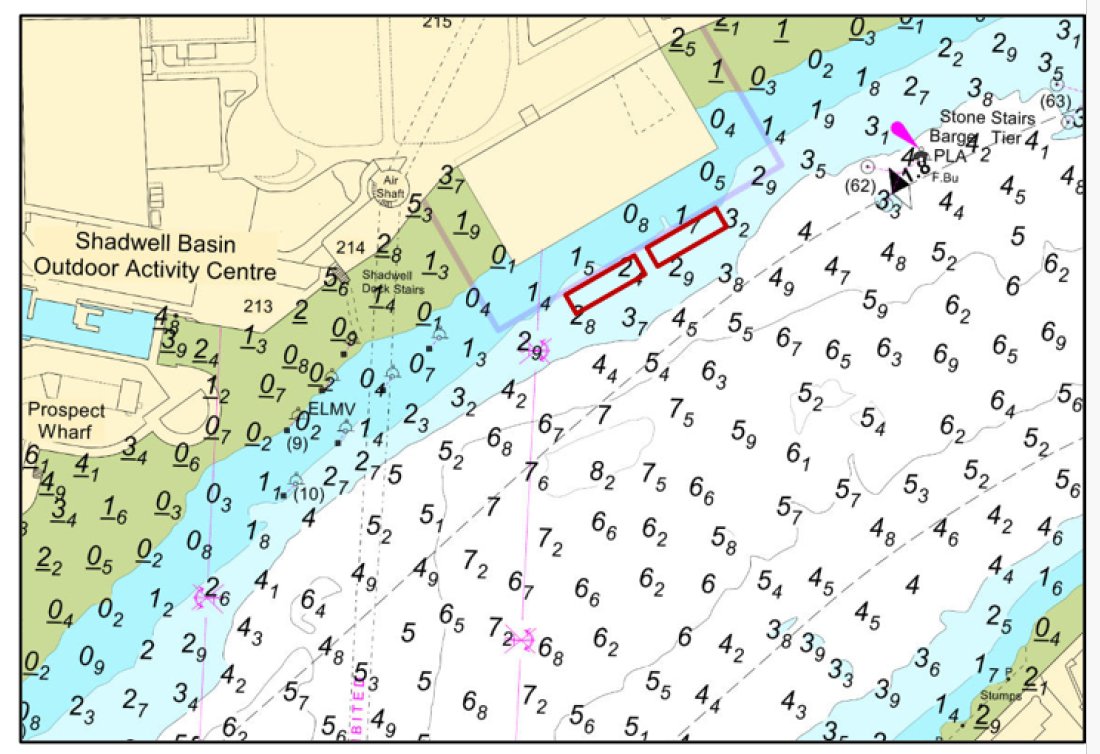


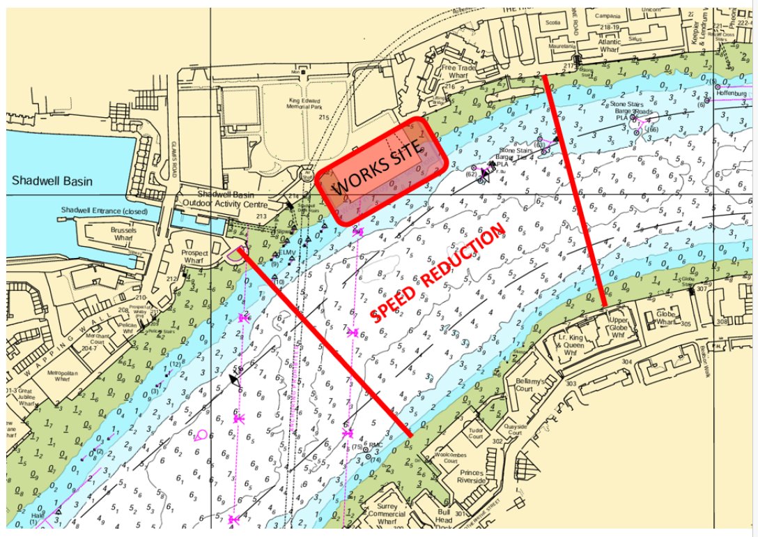


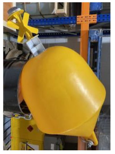
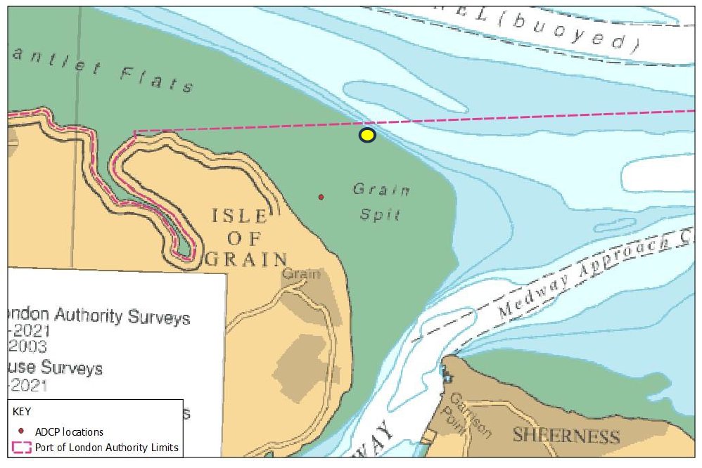
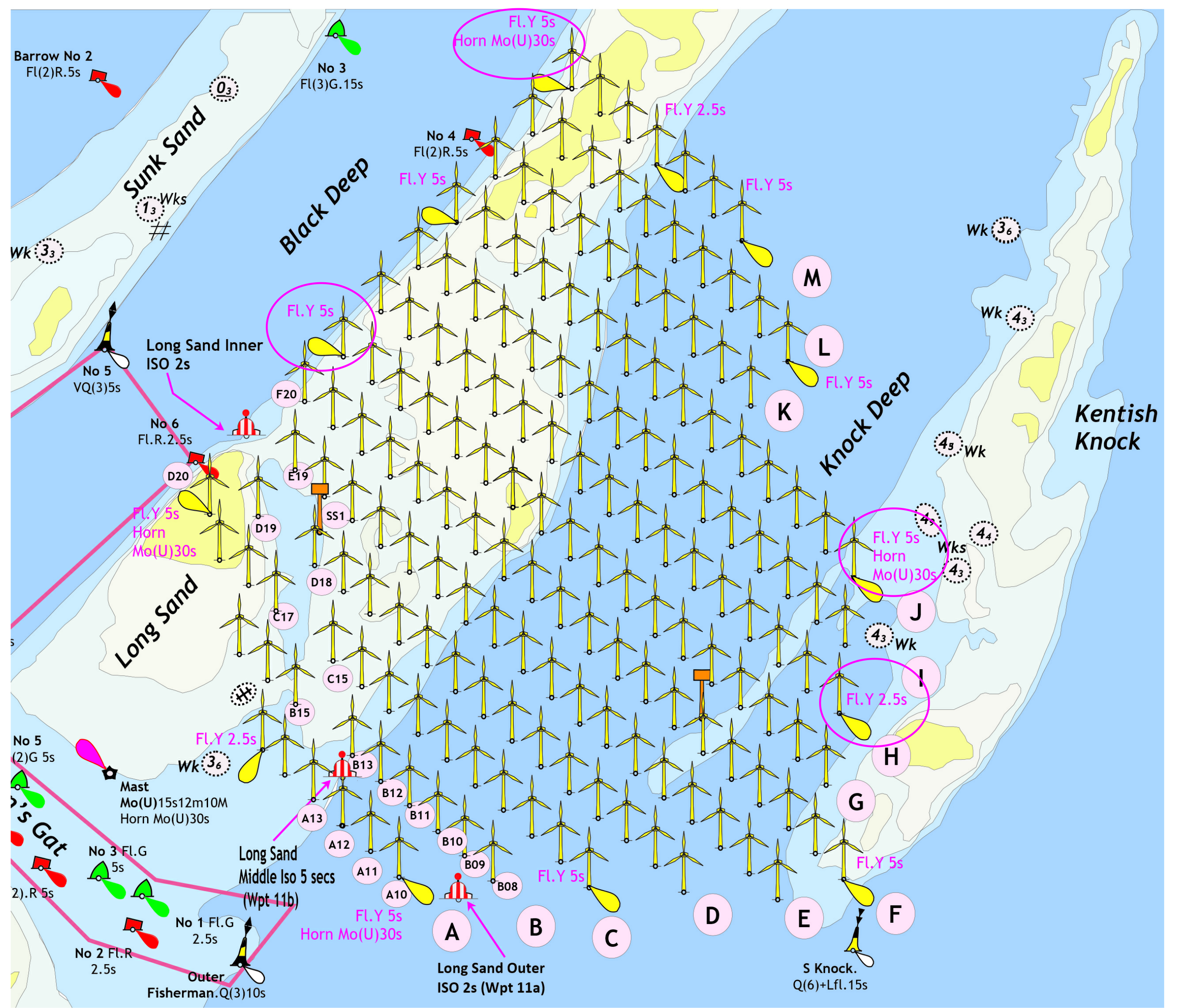
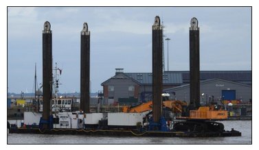
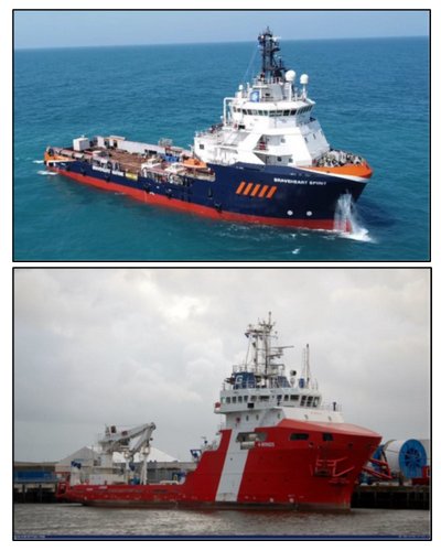
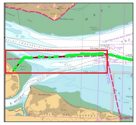
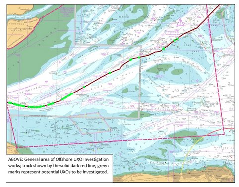
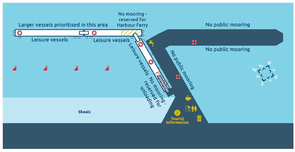
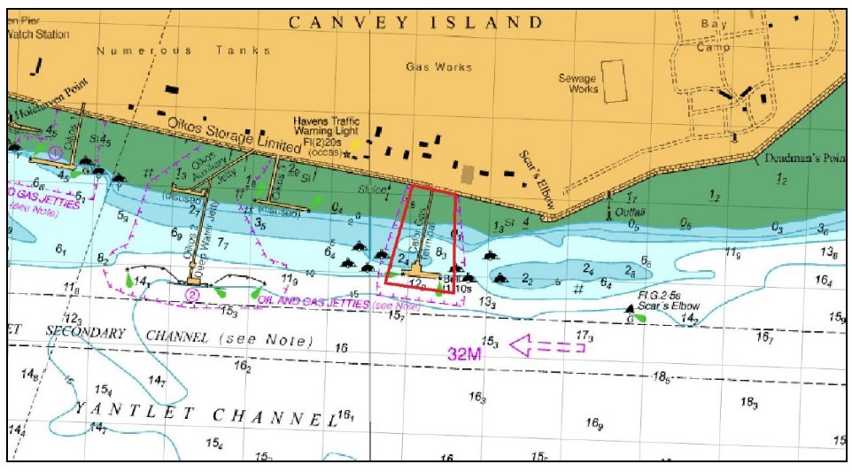

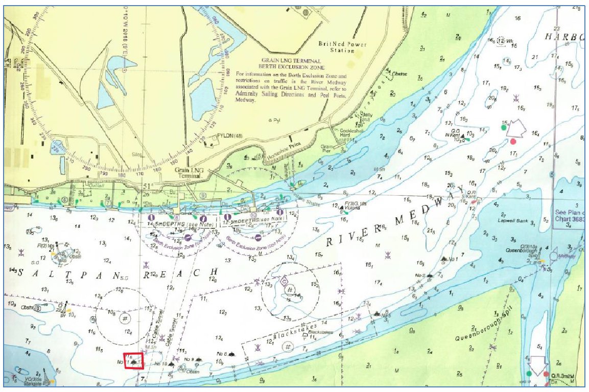
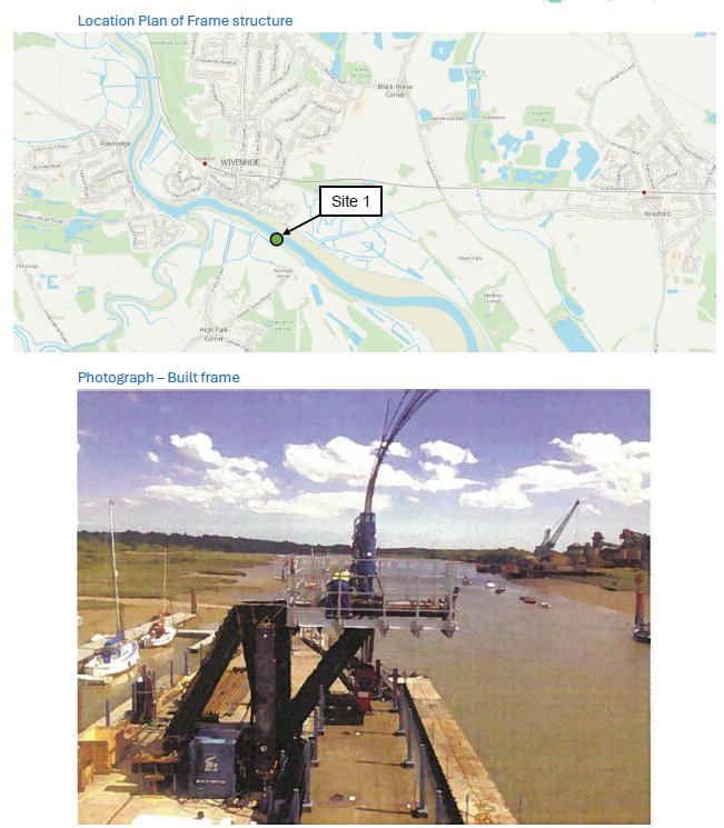

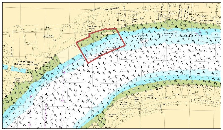
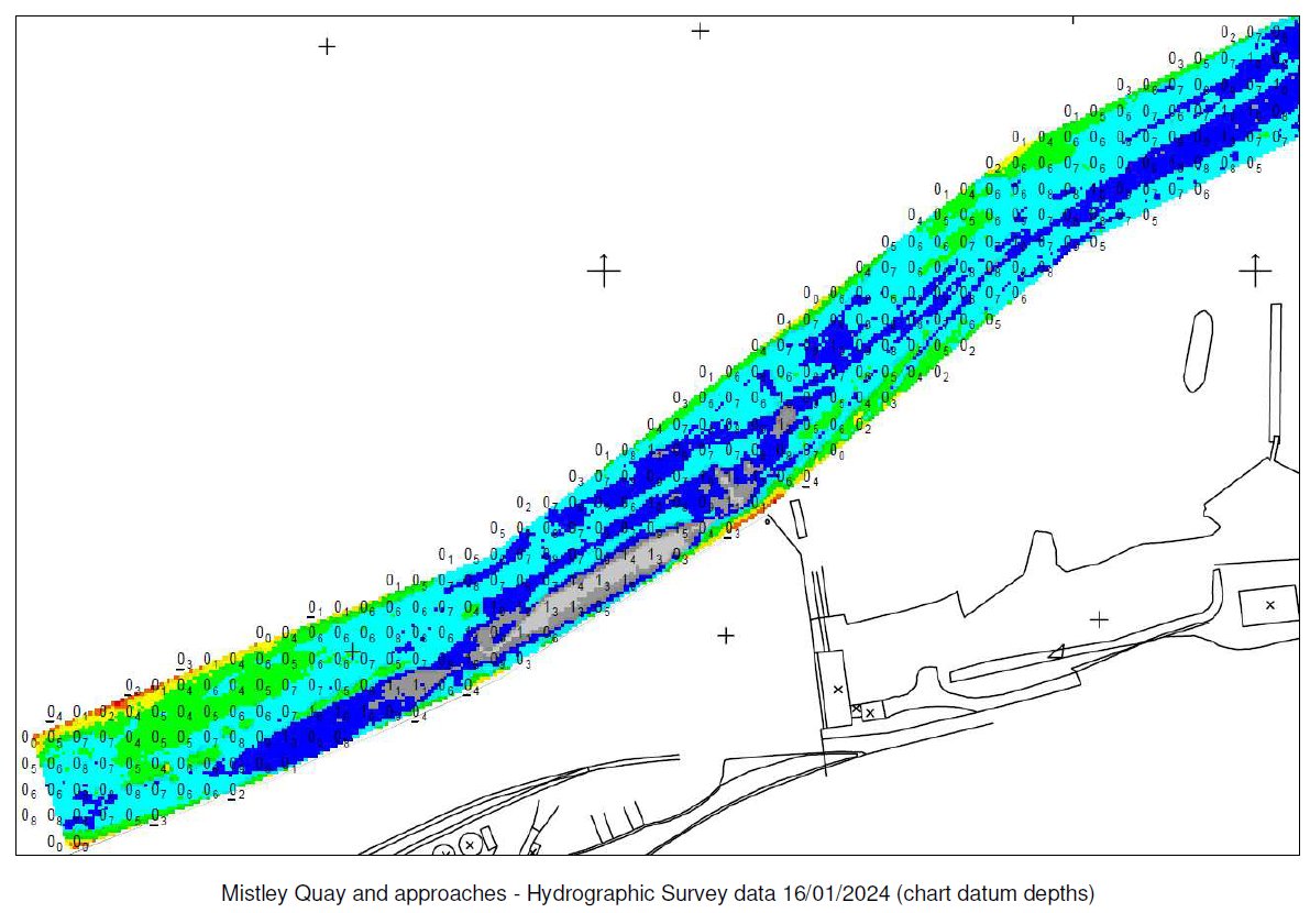
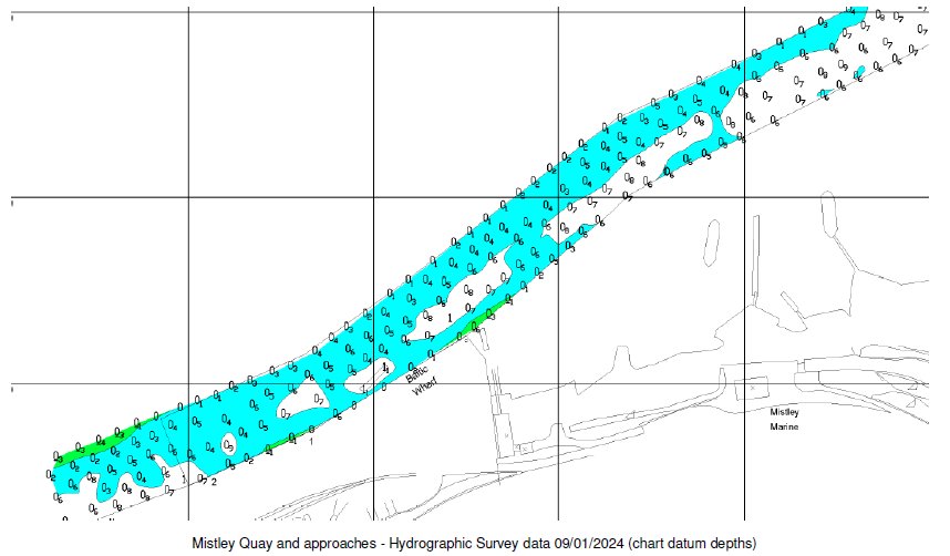
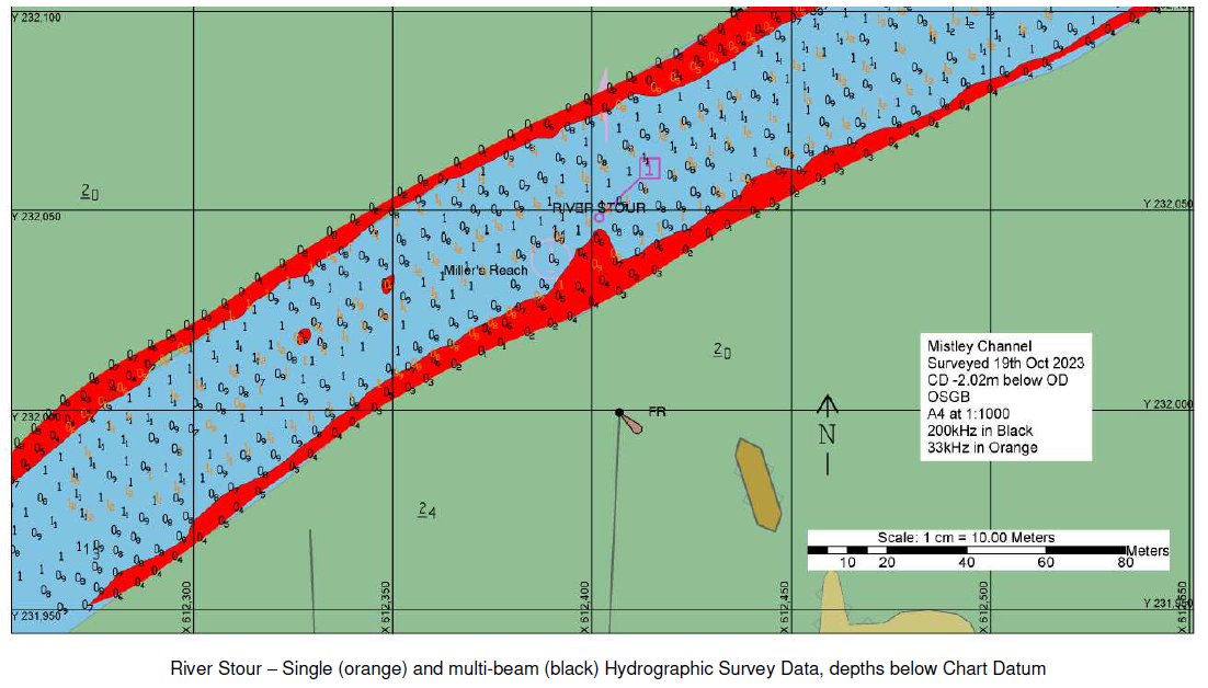
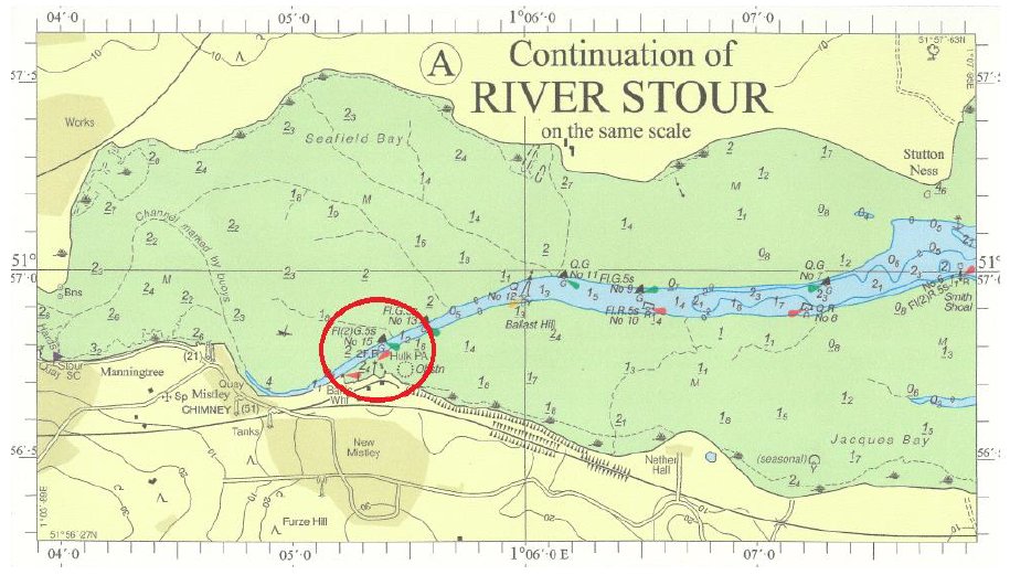
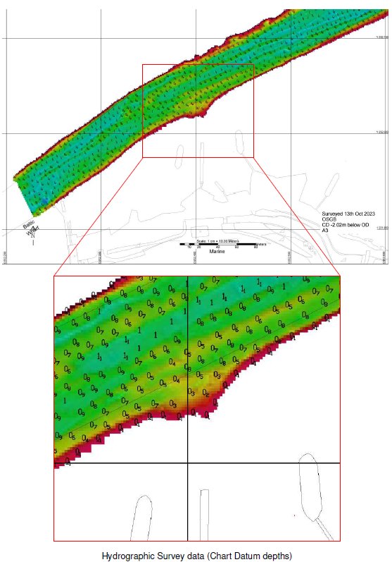
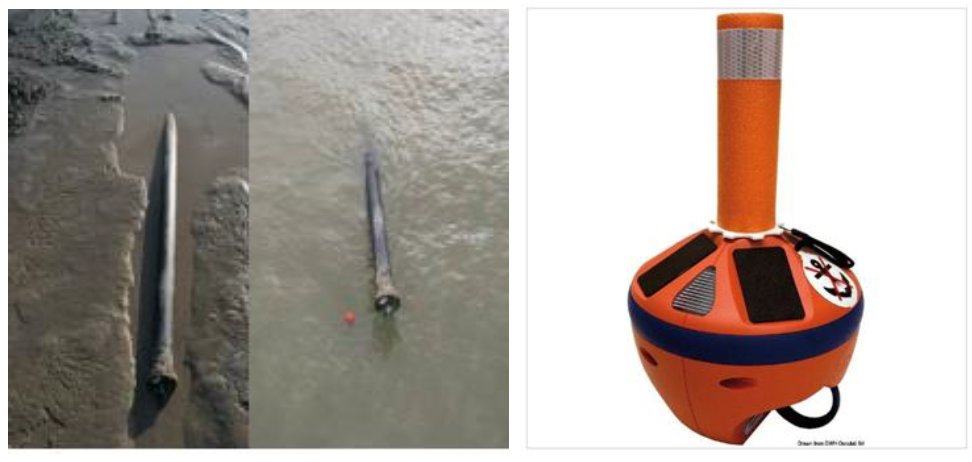
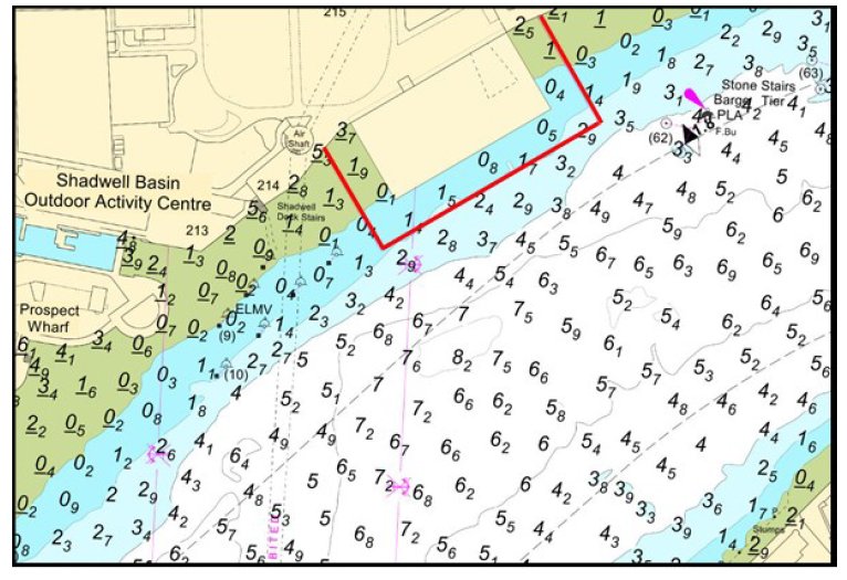


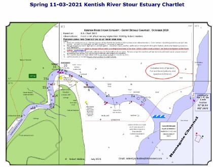
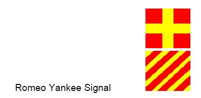
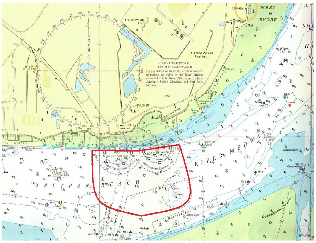
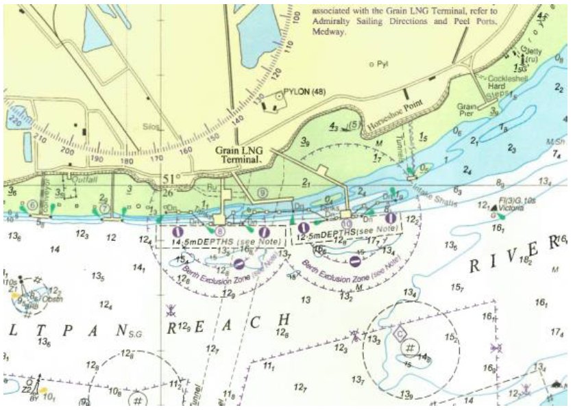
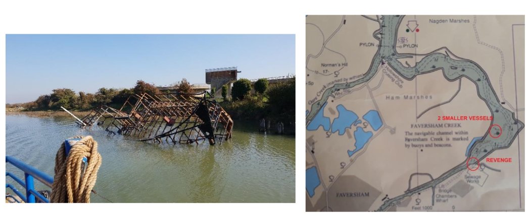

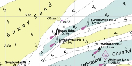
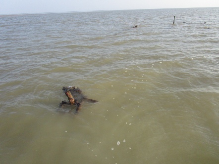
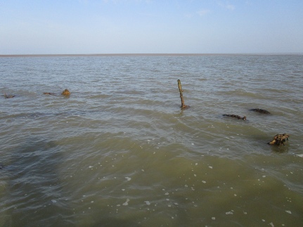
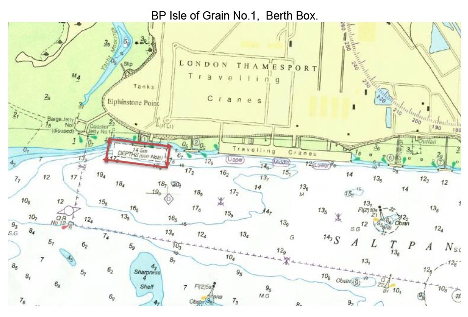