|
Notices - |
||
|
Week 51 |
BELGIUM - A North cardinal light-
Base image courtesy of Imray ID10 Chart C30 and Meridian Chartware |
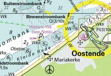
Affects: UKHO Charts: 1872, 1873, 1874 and 2449 Imray Charts: C30 New North Cardinal Buoy temporarily installed on the north side of the Kleine Rede channel approaching Ostend from the West.
|
|
Week 43 |
BELGIUM - Chart 1872 Insert the accompanying block, centred on: 51° 36’ ·5N. , 2° 49’ ·3E. Chart 1874 Insert the accompanying block, centred on: 51° 36’ ·2N. , 2° 49’ ·8E. Chart 2449 Insert:
51° 40´·66N., 2° 43´·31E. 51° 39´·71N., 2° 44´·15E. 51° 39´·27N., 2° 43´·80E. 51° 38´·58N., 2° 45´·16E. and 51° 37´·45N., 2° 50´·66E. 51° 37´·17N., 2° 50´·34E. 51° 36´·21N., 2° 50´·08E. 51° 35´·57N., 2° 49´·57E.
Base image courtesy of Imray ID10 Chart C30 and Meridian Chartware |
Affects: UKHO Charts: 1872 and 1874. Imray Charts: C30 Two UKHO blocks are issued for two charts each covering the new submarine power cable for the Belwind Wind Farm. Co-
|
|
Week 41 |
BELGIUM - Note: Light designations and radar beacon remain unchanged. Amend: light to Fl(5)20s at: 51° 21´·63N., 3° 07´·10E. 51° 23´·38N., 3° 11´·93E. 51° 21´·77N., 3° 17´·41E.
Base image courtesy of Imray ID10 Chart C30 and Meridian Chartware |
Affects: UKHO Charts: 1630, 1872, 1874 and 2449. Imray Charts: Y30 The three MOW beacons; MOW1, MOW2 and MOW3 have been changed lights from yellow to white. Otherwise no other changes.
|
|
Week 40 |
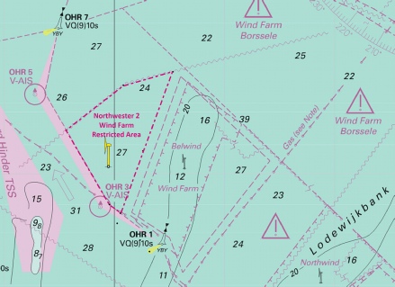
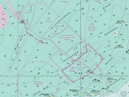
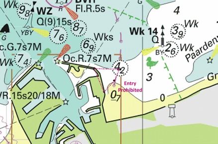
BELGIUM - Note: Former Notice 3093(P)/20 is cancelled. Insert: symbol, wind turbine, Fl(3)Y.15s Horn Mo(U)15s at: 51° 42´·56N., 2° 46´·91E. 51° 41´·30N., 2° 43´·41E. 51° 40´·56N., 2° 44´·04E. 51° 39´·50N., 2° 45´·07E. symbol, wind farm, Northwester 2 at 51° 42´·00N., 2° 45´·48E. limit of restricted area, entry prohibited, pecked line, joining: 51° 42´·89N., 2° 47´·67E. 51° 38´·89N., 2° 45´·29E. 51° 39´·13N., 2° 44´·78E. 51° 41´·24N., 2° 42´·82E. 51° 42´·51N., 2° 45´·42E.
Base image courtesy of Imray ID10 Chart C30 and Meridian Chartware |
Affects: UKHO Charts: 1630 Imray Charts: C30 This notice repeats the Preliminary NtM 3093(P) earlier this year. Note the marked area of the Wind Farm is restricted.
|
|
Week 39 |
BELGIUM - Insert: depth, 13.5 at 51° 20´·20N., 2° 35´·62E. Delete depth, 14.8, close N. depth, 18.2 at 51° 22´·47N., 2° 34´·51E. Delete depth, 18.6, close SW depth, 18.8 at 51° 24´·53N., 2° 38´·53E. Delete depth, 19.3, close SE depth, 14.9 at 51° 19´·84N., 2° 35´·72E. Delete depth, 15.7, close SE Replace: depth, 13.6, with depth, 13.1 at 51° 21´·52N., 2° 31´·67E..
Base image courtesy of Imray ID10 Chart C30 and Meridian Chartware |
Affects: UKHO Charts: 1406, 1872, 1873 and 2449 Imray Charts: C30 5 new reductions of depth east of the Oost Dyck bank. At all over 13m or more, unlikely to hinder leisure craft.
|
|
Week 39 |
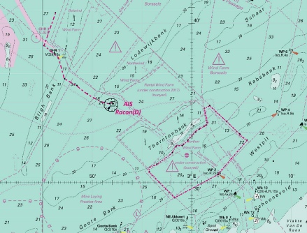
BELGIUM - Note: Former Notice 242(T)/19 is cancelled. Insert: Automatic Identification System, AIS, at platform radar beacon, Racon(D), at platform circular limit of restricted area, radius 515m, , all centred on 51° 34´·94N., 2° 52´·12E.
Base image courtesy of Imray ID10 Chart C30 and Meridian Chartware |
Affects: UKHO Charts: 1630 Imray Charts: C30 A new control tower for the Belgium Rentel Wind Farm with AIS, Racon(D) and an exclusion zone.
|
|
Week 36 |
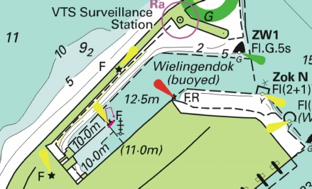
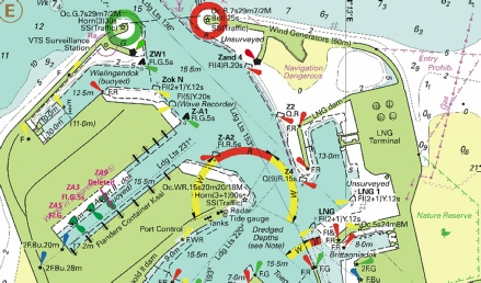
BELGIUM - Insert: jetty, single firm line, joining: (a) 51° 21´·32N., 3° 10´·68E. (b) 51° 21´·34N., 3° 10´·71E. Move:
Base image courtesy of Imray ID10 Chart C30E and Meridian Chartware |
Affects: UKHO Charts: 1874 Imray Charts: C30E New Jetty in the Wielingendok in Zeebrugge and the light moved to the end of the new Jetty.
|
|
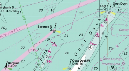
Week 36 |
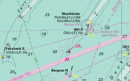
BELGIUM - Replace: depth, 16.3, with depth 15.7 at 51° 21´·54N., 2° 24´·38E. Insert: depth, 22 at 51° 20´·98N., 2° 24´·17E. Delete depth, 23, close SE.
Base image courtesy of Imray ID10 Chart C30 and Meridian Chartware |
Affects: UKHO Charts: 323, 1872, 1873 and 2449 Imray Charts: C30 Two reductions of depth on the edge of the West Hinder TSS north of the Bergues N cardinal buoy. Unlikely to hinder leisure craft.
|
|
Week 26 |
New Editions of ADMIRALTY Charts 9th July, 2020 Chart 1872 - Blankenberge. 1:15,000 Chart 1874 - 1:60,000 A Zeebrugge. 1:20,000 B Brugge. 1:15,000 |
Includes significant safety- Includes significant safety- |
|
Week 25 |
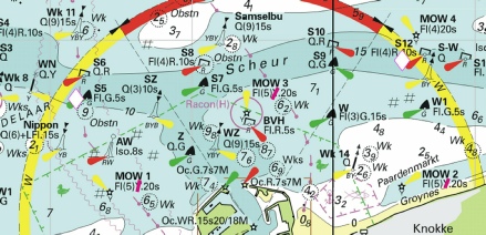
BELGIUM - Buoyage. Following the completion of the Norther Wind Farm, a safety zone, entry prohibited, has been established, joining the following positions: 51° 30´·69N., 2° 55´·74E. 51° 29´·04N., 2° 58´·32E. 51° 30´·51N., 3° 02´·68E. 51° 30´·57N., 3° 02´·76E. 51° 32´·66N., 3° 05´·56E. 51° 33´·01N., 3° 04´·88E. 51° 33´·05N., 3° 04´·81E. 51° 33´·82N., 3° 03´·53E. 51° 33´·83N., 3° 03´·51E. 51° 34´·83N., 3° 01´·83E. 51° 34´·65N., 3° 01´·29E. 51° 33´·77N., 3° 01´·55E. 51° 33´·62N., 3° 01´·48E. 51° 33´·52N., 3° 01´·27E. 51° 33´·36N., 3° 00´·79E. 51° 33´·17N., 3° 00´·39E. 51° 32´·92N., 3° 00´·02E. 51° 32´·65N., 2° 59´·63E. 51° 32´·39N., 2° 59´·18E. 51° 32´·31N., 2° 59´·05E. 51° 32´·30N., 2° 58´·48E. 51° 31´·87N., 2° 58´·06E. 51° 31´·15N., 2° 56´·48E. 51° 30´·96N., 2° 55´·83E. A submarine power cable has been laid, joining the following positions: 51° 40´·65N., 2° 46´·32E. 51° 38´·60N., 2° 45´·14E. 51° 38´·12N., 2° 46´·18E. 51° 37´·80N., 2° 46´·61E. 51° 36´·52N., 2° 47´·23E. 51° 36´·10N., 2° 48´·45E. 51° 35´·55N., 2° 49´·55E. 51° 35´·05N., 2° 50´·90E. 51° 34´·96N., 2° 51´·74E. 51° 35´·00N., 2° 51´·98E. 51° 34´·95N., 2° 52´·10E. Within the Port of Zeebrugge lights have been established in the following positions: Characteristic Position F.G 51° 21´·61N., 3° 11´·25E. F.R 51° 21´·56N., 3° 12´·28E. Changes to the works area within Albert II- Characteristic Designation Former Position New Position Fl.G.5s ZA3 51° 20´·97N., 3° 11´·25E. 51° 20´·85N., 3° 11´·00E. Q.G ZA5 51° 20´·87N., 3° 11´·07E. 51° 20´·73N., 3° 10´·76E. The port hand light- These changes will be included in New Editions of Charts 1872, 1874 and 2449 to be published mid 2020. Charts 110, 1630 and 1406 will be updated by Notice to Mariners. Former Notice 2578(P)/20 is cancelled. (WGS84 DATUM) Notice 2973(P) refers |
Affects: UKHO Charts: 110, 1630, 1872, 1874, 2449 and 8012 Imray Charts: C30 This notice is identical to NtM 2578(P) issued in week 21. This notifies the restricted area of the Norther Wind Farm, submarine cable and lights changes within Zeebrugge. Refer to the images in the notice in week 21 or use the usual download button there.
|
|
Week 25 |
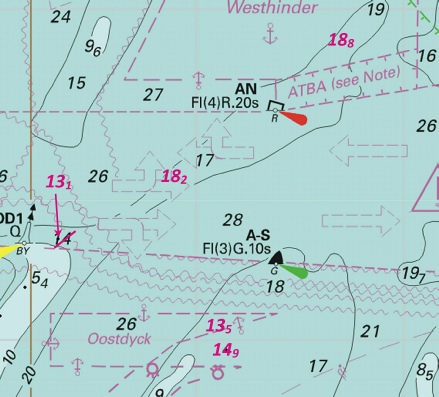
BELGIUM - Insert: limit of restricted area, entry prohibited, pecked line, joining: 51° 42´·89N., 2° 47´·67E. 51° 38´·89N., 2° 45´·29E. 51° 39´·13N., 2° 44´·78E. 51° 41´·24N., 2° 42´·82E. 51° 42´·51N., 2° 45´·42E. symbol, wind turbine at 51° 41´·54N., 2° 45´·33E.
Base image courtesy of Imray ID10 Chart C30 and Meridian Chartware |
Affects: UKHO Charts: 1406 Imray Charts: C30 A new restricted Wind Farm area, the Northwester 2 Wind Farm, north-
|
|
Week 25 |
BELGIUM - Following the completion of the Northwester 2 Wind Farm, a safety zone, entry prohibited, has been established, joining the following positions: 51° 41´·24N., 2° 42´·82E. 51° 42´·51N., 2° 45´·42E. 51° 42´·89N., 2° 47´·67E. 51° 38´·89N., 2° 45´·29E. 51° 39´·13N., 2° 44´·78E. Wind turbines, Fl(3)Y.15s5M Horn, have been established in the following positions: 51° 41´·30N., 2° 43´·41E. 51° 41´·97N., 2° 44´·80E. 51° 42´·56N., 2° 46´·91E. 51° 41´·35N., 2° 46´·19E. 51° 39´·50N., 2° 45´·07E. 51° 40´·56N., 2° 44´·04E. Charts 1630 and 8297 will be updated when full details are available. These changes will be included in a New Edition of Chart 1234 to be published mid 2020. Charts 1406 will be updated by Notice to Mariners. Former Notice 3989(P)/19 is cancelled. (WGS84 DATUM)
Base image courtesy of Imray ID10 Chart C30 and Meridian Chartware |
Affects: UKHO Charts: 1630, 2449 and 8297 Imray Charts: C30 This notice is a Preliminary notice additional to Notice 3096 above. This shows the Northwester 2 Wind Farm in a more detailed scale including the positions of the individual wind turbines. It is not my fault that one turbines is outside of the Wind Farm limits!
|
|
Week 21 |
BELGIUM - Chart 1406 Insert the accompanying block, centred on: 51° 32´·4N., 2° 57´·4E.
The Block is copyright of the UKHO |
Affects: UKHO Charts: 1406 Imray Charts: C30 A UKHO block for chart 1406. This shows the western edge of the Norther Wind Farm.
|
|
Week 21 |
BELGIUM - Buoyage. Following the completion of the Norther Wind Farm, a safety zone, entry prohibited, has been established, joining the following positions: 51° 30´·69N., 2° 55´·74E. 51° 29´·04N., 2° 58´·32E. 51° 30´·51N., 3° 02´·68E. 51° 30´·57N., 3° 02´·76E. 51° 32´·66N., 3° 05´·56E. 51° 33´·01N., 3° 04´·88E. 51° 33´·05N., 3° 04´·81E. 51° 33´·82N., 3° 03´·53E. 51° 33´·83N., 3° 03´·51E. 51° 34´·83N., 3° 01´·83E. 51° 34´·65N., 3° 01´·29E. 51° 33´·77N., 3° 01´·55E. 51° 33´·62N., 3° 01´·48E. 51° 33´·52N., 3° 01´·27E. 51° 33´·36N., 3° 00´·79E. 51° 33´·17N., 3° 00´·39E. 51° 32´·92N., 3° 00´·02E. 51° 32´·65N., 2° 59´·63E. 51° 32´·39N., 2° 59´·18E. 51° 32´·31N., 2° 59´·05E. 51° 32´·30N., 2° 58´·48E. 51° 31´·87N., 2° 58´·06E. 51° 31´·15N., 2° 56´·48E. 51° 30´·96N., 2° 55´·83E. A submarine power cable has been laid, joining the following positions: 51° 40´·65N., 2° 46´·32E. 51° 38´·60N., 2° 45´·14E. 51° 38´·12N., 2° 46´·18E. 51° 37´·80N., 2° 46´·61E. 51° 36´·52N., 2° 47´·23E. 51° 36´·10N., 2° 48´·45E. 51° 35´·55N., 2° 49´·55E. 51° 35´·05N., 2° 50´·90E. 51° 34´·96N., 2° 51´·74E. 51° 35´·00N., 2° 51´·98E. 51° 34´·95N., 2° 52´·10E. Within the Port of Zeebrugge lights have been established in the following positions: Characteristic Position F.G 51° 21´·61N., 3° 11´·25E. F.R 51° 21´·56N., 3° 12´·28E. Changes to the works area within Albert II- Characteristic Designation Former Position New Position Fl.G.5s ZA3 51° 20´·97N., 3° 11´·25E. 51° 20´·85N., 3° 11´·00E. Q.G ZA5 51° 20´·87N., 3° 11´·07E. 51° 20´·73N., 3° 10´·76E. The port hand light- These changes will be included in New Editions of Charts 1872, 1874 and 2449 to be published mid 2020. Charts 110, 1630 and 1406 will be updated by Notice to Mariners. Former Notice 1745(P)/18 is cancelled. (WGS84 DATUM)
Base image courtesy of Imray ID10 Chart C30 and Meridian Chartware |
Affects: UKHO Charts: 110, 1630, 1872, 1874, 2449 and 8012 Imray Charts: C30 Three distinct changes: 1. The Norther Wind Farm is now complete and the limits of the Wind Farm (and its prohibited zone) is now defined. 2. A new Submarine Power Cable has been installed from north of the Belwind Wind Farm to close to the Rentel Wind Farm. 3. Two new lights just inside of Zeebrugge harbour and changes in buoyage in one of the shipping docks
|
|
Week 18 |
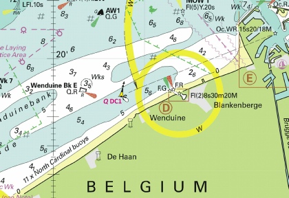
BELGIUM - A north cardinal light- (WGS84 DATUM)
Base image courtesy of Imray ID10 Chart C30 and Meridian Chartware |
Affects: UKHO Charts: 1872 and 1874 Imray Charts: C30 New north cardinal buoy temporarily installed in the middle of the Wenduine channel leading to Blankenberge.
|
|
Week 18 |
BELGIUM - Depths up to 1m less than charted have been reported in the vicinity of position 51° 09´·37N., 2° 43´·07E. (WGS84 DATUM)
Base image courtesy of Imray ID10 Chart C30 and Meridian Chartware |
Affects: UKHO Charts: 1872, 1873 and 1874 Imray Charts: C30 Some serious depth problems right at the entrance to Nieuwpoort. Normally a 3m channel is maintained but is reported as less than 1m. I am sure we can expect some early dredging.
|
|
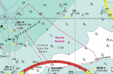
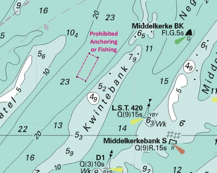
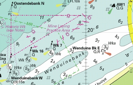
Week 18 |
BELGIUM - A marine reserve area has been established, bounded by the following positions: 51° 31´·34N., 3° 08´·23E. 51° 29´·03N., 3° 12´·66E. 51° 26´·95N., 3° 17´·71E. 51° 26´·17N., 3° 18´·35E. 51° 25´·47N., 3° 11´·86E. 51° 30´·12N., 3° 06´·27E. Marine reserve areas have been updated. The limits have been changed as follows: Update Positions Insert 51° 14´·51N., 2° 55´·46E. 51° 20´·70N., 2° 47´·01E. 51° 28´·86N., 2° 34´·68E. Delete 51° 16´·70N., 2° 52´·46E. 51° 28´·86N., 2° 34´·68E. Delete 51° 08´·25N., 2° 30´·32E. 51° 16´·75N., 2° 52´·54E. 51° 14´·47N., 2° 54´·99E. A restricted area, anchoring and fishing prohibited, has been established, bounded by the following positions: 51° 17´·63N., 2° 37´·69E. 51° 17´·49N., 2° 38´·14E. 51° 16´·73N., 2° 37´·51E. 51° 16´·87N., 2° 37´·07E. The limits of a mine- Update Positions Insert 51° 21´·00N., 2° 53´·00E. 51° 21´·00N., 2° 59´·49E. 51° 18´·53N., 2° 53´·00E. Delete 51° 21´·00N., 2° 57´·10E. 51° 21´·00N., 3° 00´·70E. 51° 18´·70N., 2° 55´·80E. 51° 19´·80N., 2° 54´·50E. A restricted area, entry prohibited, marine reserve, bounded by the following positions has been deleted: 51° 21´·63N., 3° 13´·25E. 51° 21´·60N., 3° 14´·20E. 51° 21´·35N., 3° 13´·97E. 51° 21´·09N., 3° 13´·60E. Mariners are advised to navigate with caution in the area. These changes will be included in New Editions of Charts 1872, 1873 and 1874 to be published mid 2020. Charts 2449 and 1630 will be updated by Notice to Mariners. (WGS84 DATUM)
Base image courtesy of Imray ID10 Chart C30 and Meridian Chartware |
Affects: UKHO Charts: 1872, 1873, 1874 and 8012 Imray Charts: C30 5 different boundary changes: 1. A new marine reserve on the Vlakte Van De Raan. 2. An update of the boundary of the Marine Reserve extending just east of Oostende harbour northerly – very small change. 3. A restricted area prohibiting anchoring and fishing near Middelkerke; a small area unmarked visually. 4. A revision of the boundaries for the min- 5. A prohibited area just east of Zeebrugge. Five separate images.
|
|
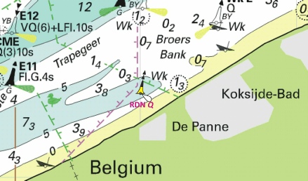
Week 16 |
BELGIUM - A North cardinal light- (WGS84 DATUM)
Base image courtesy of Imray ID10 Chart C30 and Meridian Chartware |
Affects: UKHO Charts: 1872 and 1873 Imray Charts: C30 New North Cardinal buoy just off the De Panne beaches of Belgium.
|
|
Week 15 |
New Editions of ADMIRALTY Charts published 9th April 2020 Chart 1872 North Sea, Dunkerque to Vlissingen. 1:100,000 Blankenberge. 1:15,000 Note: On publication of this New Edition former Notices 1964(T)/18, 1749(P)/20 and 3524(T)/19 are cancelled. This chart remains affected by Notices 1745(P)/18, 242(T)/19, 428(P)/19, 1157(T)/19, 2320(T)/19, 2927(P)/19 and 6214(T)/19. Chart 1873 International Chart Series, North Sea, Dunkerque to Oostende. 1:60,000 A Oostende. 1:15,000 B Nieuwpoort. 1:20,000 Note: On publication of this New Edition former Notices 1964(T)/18 and 1749(P)/20 are cancelled. This chart remains affected by Notice 2320(T)/19. Chart 1874 International Chart Series, North Sea, Westerschelde, Oostende to Westkapelle. 1:60,000 A Zeebrugge. 1:20,000 B Brugge. 1:15,000 Note: On publication of this New Edition former Notices 3524(T)/19 and 1749(P)/20 are cancelled. This chart remains affected by Notices, 1745(P)/18, 242(T)/19, 428(P)/19, 1157(T)/19, 2927(P)/19 and 6214(T)/19. |
Includes significant safety- Includes significant safety- and buoyage. (A modified reproduction of INT1480 published by Belgium). Includes significant safety- (A modified reproduction of INT1474 published by Belgium). |
|
Week 14 |
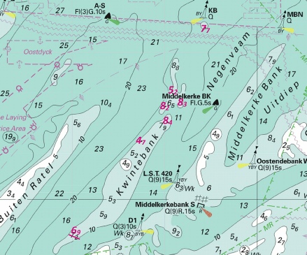
BELGIUM - Depths less than charted exist in the vicinity of Oostdyck, Middelkerkebank and Sierra Ventana, the most significant are as follows: Depth Position 15·7m 51° 18´·46N., 2° 22´·31E. 13·3m 51° 18´·93N., 2° 24´·40E. 6·2m 51° 18´·34N., 2° 23´·95E. 5·4m 51° 17´·94N., 2° 23´·71E. 14·1m 51° 17´·59N., 2° 23´·89E. 5·1m 51° 20´·79N., 2° 30´·87E. 5·6m 51° 20´·36N., 2° 30´·28E. 4·2m 51° 18´·96N., 2° 29´·10E. 5·9m 51° 15´·45N., 2° 42´·55E. 6m 51° 16´·64N., 2° 44´·98E. 7·1m 51° 16´·96N., 2° 45´·28E. 7·2m 51° 16´·79N., 2° 43´·08E. 4·8m 51° 17´·17N., 2° 42´·73E. 5·5m 51° 17´·57N., 2° 43´·18E. 5·4m 51° 18´·02N., 2° 43´·75E. 5·6m 51° 18´·65N., 2° 44´·45E. 9·7m 51° 20´·43N., 2° 46´·62E. 12·1m 51° 20´·73N., 2° 47´·31E. * 11·5m 51° 25´·57N., 3° 00´·27E. * 7·1m 51° 26´·96N., 3° 02´·34E. * 5·4m 51° 25´·82N., 3° 03´·97E. Mariners are advised to navigate with caution in the area. These changes will be included in a New Edition of Charts 1872, 1873 and 1874 to be published mid 2020. Former Notice 1109(P)/20 is cancelled. * Indicates new or revised entry.
Base image courtesy of Imray ID10 Chart C30 and Meridian Chartware |
Affects: UKHO Charts: 1872, 1873 and 1874 Imray Charts: C30 Preliminary Notice 1109(P) in week 9 this year provided information about 18 reduced depths in and around the Oostdyck, Middelkerkebank and Sierra Ventana banks. This notice adds three reduced depths north of Zeebrugge but these are unlikely to hinder leisure craft.
|
|
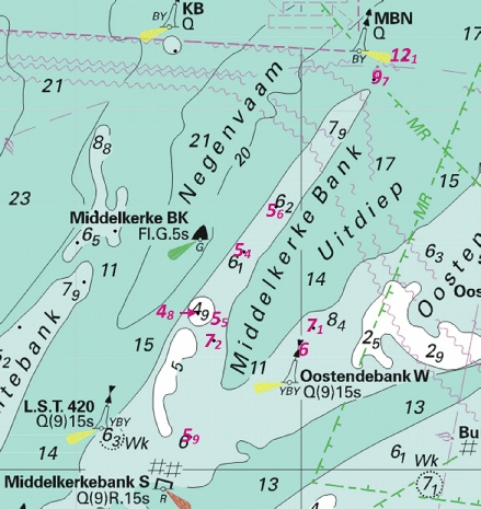
Week 9 |
BELGIUM - Depths less than charted exist in the vicinity of Oostdyck and Middelkerkebank, the most significant are as follows: Depth Position 15·7m 51° 18´·46N., 2° 22´·31E. 13·3m 51° 18´·93N., 2° 24´·40E. 6·2m 51° 18´·34N., 2° 23´·95E. 5·4m 51° 17´·94N., 2° 23´·71E. 14·1m 51° 17´·59N., 2° 23´·89E. 5·1m 51° 20´·79N., 2° 30´·87E. 5·6m 51° 20´·36N., 2° 30´·28E. 4·2m 51° 18´·96N., 2° 29´·10E. 5·9m 51° 15´·45N., 2° 42´·55E. 6m 51° 16´·64N., 2° 44´·98E. 7·1m 51° 16´·96N., 2° 45´·28E. 7·2m 51° 16´·79N., 2° 43´·08E. 4·8m 51° 17´·17N., 2° 42´·73E. 5·5m 51° 17´·57N., 2° 43´·18E. 5·4m 51° 18´·02N., 2° 43´·75E. 5·6m 51° 18´·65N., 2° 44´·45E. 9·7m 51° 20´·43N., 2° 46´·62E. 12·1m 51° 20´·73N., 2° 47´·31E. Mariners are advised to navigate with caution in the area. These changes will be included in a New Edition of Charts 1872, 1873 and 1874 to be published mid 2020.
Base image courtesy of Imray ID10 Chart C30 and Meridian Chartware |
Affects: UKHO Charts: 1872, 1873 and 1874 Imray Charts: C30 A preliminary notice notifying of 18 reduced depths over the Oostdyck and Middelkerkebank.
|
|
Week 9 |
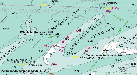
BELGIUM - Insert: depth, 14.1 at 51° 17´·59N., 2° 23´·89E. depth, 15.7 at 51° 18´·46N., 2° 22´·31E. depth, 15.5 at 51° 18´·85N., 2° 23´·60E. Delete depth, 17.7, close NW. depth, 13.3 at 51° 18´·93N., 2° 24´·40E. Delete depth, 14.1, close N. depth, 17.5 at 51° 19´·41N., 2° 25´·03E. Delete depth, 18.5, close SE. depth, 6.2 at 51° 18´·34N., 2° 23´·95E. Delete depth, 7.4, close NE. depth, 10.3 at 51° 18´·28N., 2° 24´·31E. Delete depth, 11.4, close S. depth, 4.2, enclosed by 5m contour at 51° 18´·96N., 2° 29´·10E. depth, 5.1 at 51° 20´·79N., 2° 30´·87E. Delete depth, 5.4, close NE. depth, 12.1 at 51° 20´·73N., 2° 47´·31E. depth, 9.7, and extend 10m contour NE to enclose 51° 20´·43N., 2° 46´·62E. depth, 5.4 at 51° 18´·02N., 2° 43´·75E. Delete depth, 6.4, close NE. depth, 6 at 51° 16´·64N., 2° 44´·98E. Delete depth, 6.9, close NW. Replace: depth, 5.8, with depth, 5.4 at 51° 17´·94N., 2° 23´·71E. depth, 6.1, with depth, 5.5 at 51° 17´·57N., 2° 43´·18E. depth, 6.8, with depth, 5.9 at 51° 15´·45N., 2° 42´·55E. depth, 14.1, with depth, 13.3 at 51° 18´·93N., 2° 24´·40E.
Base image courtesy of Imray ID10 Chart C1 and Meridian Chartware |
Affects: UKHO Charts: 323 and 2449 Imray Charts: C30 This ‘permanent’ notice adds four reduced depths to the above preliminary notice. The images include both sets of reduced depths.
|
|
Week 3 |
New Editions of ADMIRALTY Leisure Folios to be published on 23rd January, 2020 SC 5605 14th Edition - 5605.1 A Western Approaches to Dover Strait. 1:500,000 B Northern Approaches to Dover Strait. 1:250,000 5605.2 Dover to Calais. 1:50,000 5605.3 Chichester to Worthing. 1:75,000 5605.4 A Worthing to Newhaven. 1:75,000 B Shoreham Harbour – Western Arm and River Adur. 1:5,000 5605.5 A Newhaven to Hastings. 1:75,000 B Sovereign Harbour. 1:15,000 5605.6 A Hastings to Dungeness. 1:75,000 B Rye. 1:25,000 5605.7 Dungeness to South Foreland. 1:75,000 5605.8 Dover to Deal. 1:37,500 5605.9 Deal to Ramsgate. 1:37,500 5605.10 Calais to Dunkerque. 1:75,000 5605.11 Dunkerque to Blankenberge. 1:100,000 5605.12 A Calais. 1:15,000 B Gravelines. 1:20,000 C Dunkerque. 1:20,000 D Nieuwpoort. 1:20,000 E Oostende. 1:15,000 5605.13 A Newhaven Harbour. 1:5,000 B Littlehampton Harbour. 1:6,250 C Brighton Marina. 1:5,000 D Folkestone Harbour. 1:5,000 5605.14 A Dover. 1:6,250 B Shoreham Harbour – Eastern Arm. 1:5,000 C Shoreham Harbour – The Canal. 1:5,000 5605.15 A Approaches to Ramsgate. 1:12,500 B Ramsgate. 1:5,000 |
|
|
Week 3 |
BELGIUM - Insert: depth, 7.7 and extend 10m contour SE to enclose 51° 20´·82N., 2° 42´·21E. Delete depth, 8.8, close N and depth, 8.9, close NW. depth, 5.2 at 51° 18´·58N., 2° 40´·46E. Delete depth, 7, close SW. depth, 8.4 at 51° 17´·60N., 2° 40´·19E. Delete depth, 9.2, close N. depth, 4.7, enclosed by 5m contour at 51° 16´·97N., 2° 38´·75E. Delete depth, 5.3, close N. depth, 6.9 at 51° 13´·84N., 2° 35´·14E. Delete depth, 7.6, close S. depth, 8.3 at 51° 18´·32N., 2° 40´·88E. Delete depth, 9, close NW. depth, 8.2 and extend 10m contour SW to enclose above 51° 18´·15N., 2° 40´·04E. Delete depth,12.6 at 51° 17´·88N., 2° 39´·77E.
Base image courtesy of Imray ID10 Chart C30 and Meridian Chartware |
Affects: UKHO Charts: 1406, 1872, 1873, 1874 and 2449 Imray Charts: C30 Seven reductions on and around the Flemish Banks of the Kwintebank. Unlikely to hinder leisure craft.
|


 submarine power cable, , joining:
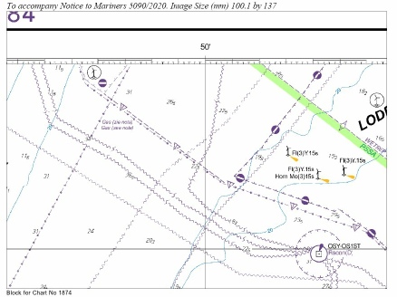

 from:
from: