|
Notices - |
||
|
Week 13 |
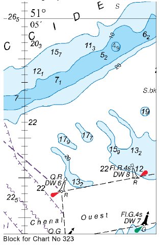
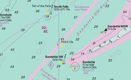
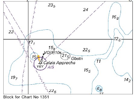
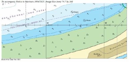
DOVER STRAIT - Insert: depth, 15.3 at 51° 21´·10N., 2° 17´·78E. Delete depth, 15.7, close NE and depth, 16.9, close SE. depth, 17.6, and extend 20m E to enclose 51° 20´·68N., 2° 18´·74E. depth, 29.5, and extend 30m contour NW to enclose 51° 17´·06N., 2° 14´·15E. Delete depth, 32, close NW. depth, 21.5 at 51° 16´·50N., 2° 14´·80E. Delete depth, 24.5, close E. depth, 26.5 of 51° 16´·32N., 2° 05´·80E. Delete depth, 28.5, close NE and N and depth, 28, close W. depth, 29, and extend 30m contour SE to enclose 51° 15´·89N., 2° 05´·83E. Chart 1351 Insert the accompanying block, centred on: 50° 59´·0N., 1° 45´·3E. Notice 1351 refers Base image courtesy of Imray ID10 Chart C30 and Meridian Chartware. The block is copyright of the UKHO
|
Affects: UKHO SNC: 323, 1351, 1406, 1610, 1872, 1873 and 2449. UKHO SCC: 5605.2, 5605.1 (Panel B, Northern Approaches to Dover Strait), 5606.1 and 5607.1 Imray Full Charts: C8 Imray Leisure Folios 2110.2 Six reduced depths in the West Hinder and Sandiettie TSS and a new UKHO block around the Calais Approche west cardinal buoy. This is deep water so should not hinder leisure craft. 2 reductions just south of the Fairybank S. south cardinal buoy and 4 reductions in the Sandiettie TSS in the junction area with the West Hinder TSS. Ample water also around the Calais west cardinal.
|
|
Week 04 |
FRANCE - Insert: depth, 1.9, enclosed by 2m and 5m contours and extend 10m contour SE to enclose 51° 09´·39N., 2° 23´·95E. depth, 5, enclosed by 5m contour at 51° 08´·60N., 2° 21´·90E. Delete depth, 5.5, close NW.
Notice 302 refers Base image courtesy of Imray ID10 Chart C30 and Meridian Chartware.
|
Affects: UKHO SNC: 1872 and 1874 UKHO SCC: 5605.10 and 5605.11 Imray Full Charts: C30 Two reductions of depth on the southern side of the Binnen Ratel bank whch is one of the off-
|
|
Week 04 |
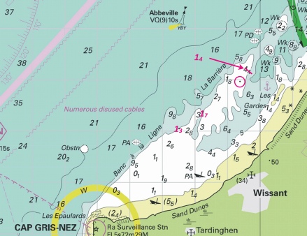
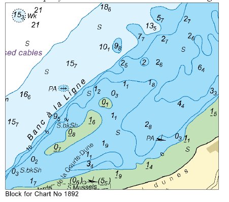
FRANCE - Insert: depth, 27 at 51° 02´·49N., 1° 36´·13E. Delete depth, 28, close E and depth, 27.5, close SW. depth, 12.6 at 51° 05´·24N., 1° 50´·71E. Delete depth, 13.5, close S. circular limit of low water line, radius 100m, centred on: 50° 54´·97N., 1° 39´·38E. Delete depth, 0.8, close N. depth, 1.7, enclosed by 2m contour at 50° 54´·38N., 1° 38´·24E. Delete depth, 2.7, close N. depth, 1.3, enclosed by 2m contour at 50° 54´·05N., 1° 37´·51E. Delete depth, 2.5, close NW. Replace: depth, 2.8, with depth, 1.4, enclosed by 2m contour at 50° 55´·18N., 1° 39´·58E.
Notice 341 refers Base image courtesy of Imray ID10 Chart IN5036 and Meridian Chartware.
|
Affects: UKHO SNC: 323, 1406, 1892 and 2449 UKHO SCC: 5605.10, 5605.2, 5605.1 (Panel B, Northern Approaches to Dover Strait) and 5606.1 Imray Full Charts: C8 Two reduction of depth in the English Channel, neither of which will hinder leisure craft, four reductions of depth on the Banc a la Ligne and La Barriere off Wissant west of Calais and a change of wreck designation east of the Colbart SW south cardinal buoy Of two reductions in the Channel, one is in the NE running TSS, the other on the tail of the Ruytingen bank. Of the four reductions of depth ‘off Wissant’, two are shown as soundings, the third is a circular limit of low water line. I admit needing to turn to ‘Symbols and Abbreviations’ for the ‘low water line level’ for the exact definition; that being the line of 0. Probably suggests trying to find a lee east of Gris Nez is not the best idea. The wreck east of the Colbart SW just in the TSS separation zone is now defined as an unsurveyed wreck over which the exact depth is unknown but is considered to have a safe clearance of 20m – so unlikely to hinder leisure craft. Note it is marked ‘PA’ i.e. positon approximate. Three images.
|
|
SCROLL DOWN FOR PRE- |
||
|
Week 49 |
FRANCE - Insert: circular limit of restricted area, radius 300m, entry prohibited, pecked line, centred on: 51° 16´·17N., 2° 17´·04E. Notice 4613 refers Base image courtesy of Imray ID10 Chart C30 and Meridian Chartware.
|
Affects: UKHO SNC: 323 and 1873 UKHO SCC: 5605.11 Imray Full Charts: C30 A restricted area of 300m radius has been imposed on the Separation Zone just at the entrance of the West Hinder TSS. This is SW of the Bergues north cardinal buoy. Note that NtM 424(T) earlier this year there was a Virtual AIS waypoint.
|
|
Week 40 |
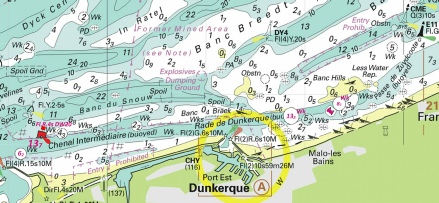
FRANCE - Insert:
Move:
Notice 3541 refers Base image courtesy of Imray ID10 Charts C2110.2 and Meridian Chartware.
|
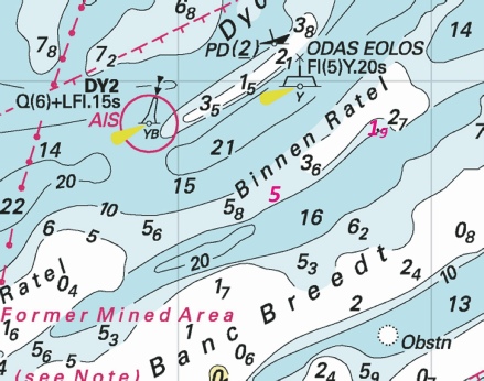
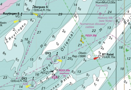
Affects: UKHO SNC: 323, 1350 and 1873 UKHO SCC: 5605.12 (Panel C, Dunkerque) and 5605.10. Imray Full Charts: C30 Imray Leisure Charts: 2110.2 Two new Yellow Special ODAS buoys close south of the Banc in Ratel (off Dunkerque) and four small moves of channel markers in the Chenal Intermediaire between the west and east entrances of Dunkerque.
|
|
Week 38 |
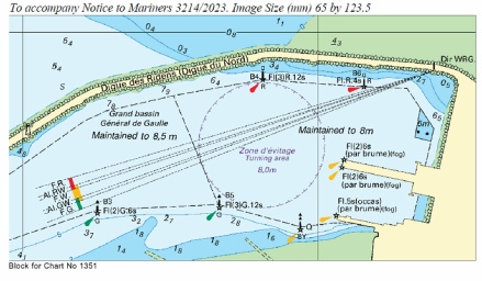
FRANCE - Insert: the accompanying block, centred on: 50° 58´·8N., 1° 51´·7E. Notice 3214 refers The block is copyright of the UKHO.
|
Affects: UKHO SNC: 1351 UKHO SCC: 5605.12A Imray Full Charts: C8G Imray Leisure Charts:2100.11D A new UKHO block showing the outer commercial basin of Calais harbour.
|
|
Week 38 |
FRANCE - Insert: depth, 5, and extend 5m contour SW to enclose 51° 08´·60N., 2° 21´·90E. Delete depth, 5.5, close NW. depth, 1.9, enclosed by 2m and 5m contours and extend 10m contour SE to enclose 51° 09´·39N., 2° 23´·95E. Notice 3238 refers Base image courtesy of Imray ID10 Charts C30 and Meridian Chartware.
|
Affects: UKHO SNC: 323 and 2449 UKHO SCC: 5605.10 and 5605.11 Imray Full Charts: C30 Two reduction of depth on the Binnen Ratel bank (one of the banks off Dunkerque). Now quite shallow and not marked. Note on the image the ODAS superbuoy is deleted as notified in an earlier NtM.
|
|
Week 28 |
FRANCE - Delete:
Notice 2364 refers Base image courtesy of Imray ID10 Chart C8 and Meridian Chartware.
|
Affects: UKHO SNC: 1406, 1872, 1873 and 2449. UKHO SCC: 5605.11, Chart 5605.1 (Panel B, Northern Approaches to Dover Strait) and 5606.1 Imray Full Charts: C8 Imray Leisure Charts: 2110.2. Deletion of the Superbuoy offshore north of Dunkerque in the Dyck Oriental channel.
|
|
Week 11 |
New Editions of ADMIRALTY Small Craft Charts to be published on 30th March, 2023 SCC 5605.10 Calais to Dunkerque. 1:75,000 SCC 5605.15 Ramsgate and Approaches 1:12,500 Approaches to Ramsgate. 1:12,500 Ramsgate. 1:5,000 SCC 5606.3 Dover to Ramsgate including Sandettié Bank. 1:75,000 SCC 5606.10 Mouth of River Medway and West Swale. 1:25,000 Ferry Reach. 1:12,500 Ramsgate 1:5,000 SCC 5606.11 Saltpan Reach to Chatham Reach. 1:25,000 Rochester. 1:12,500 Approaches to Ramsgate. 1:12,500 |
Includes full updates for New Edition and Notices to Mariners affecting source charts. |
|
SCROLL DOWN FOR PRE- |
||
|
Week 44 |
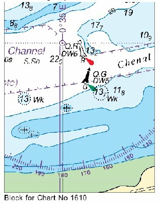
FRANCE - Replace:
Notice 4249 refers Base image courtesy of Imray ID10 Chart C30 and Meridian Chartware.
|
Affects: UKHO Charts: 1350, 1872 and 1873 UKHO Leisure Charts: 5605.10 Imray Charts: C30 Notice 2304 in Week 22 announced a new outfall off Dunkerque West. A new North Cardinal Buoy is established marking the seaward side of the outfall which does just intrude into the Chenal Intermediaire off Dunkerque West and East.
|
|
Week 27 |
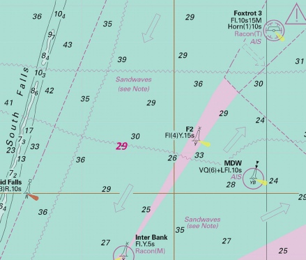
FRANCE - Insert: depth, 18.1, and extend 20m contour S to enclose 51° 20´·31N., 2° 18´·68E. Delete depth, 20.4, close SW. depth, 11 at 50° 58´·91N., 1° 45´·46E. Notice 2911 refers Base image courtesy of Imray ID10 Charts C8 and C30 and Meridian Chartware.
|
Affects: UKHO Charts: 322, 1351, 1406, 1610, 1872, 173, 1892 and 2449. UKHO Leisure Charts: 5605.1 (Panel B, Northern Approaches to Dover Strait), 5606.1, 5607.1 Imray Charts: C8 and C30 Two reductions of depth well apart but both unlikely to hinder leisure craft: one south of the Fairbank S Cardinal buoy in the West Hinder west-
|
|
Week 22 |
New Editions of ADMIRALTY Small Craft Charts published 02 June 2022 Chart 5605.10 Calais to Dunkerque. 1:75,000 New Editions of ADMIRALTY Small Craft Charts published 16 June 2022 Chart 5605.2 Dover to Calais. 1:150,000 |
Includes updated hydrography and changes to charted detail. Note: This chart is to be deleted from the list of charts affected by Notice 638(P)/22. Includes full updates for New Edition and Notices to Mariners affecting source charts |
|
Week 22 |
FRANCE - Insert: outfall, 51° 02´·81N., 2° 15´·74E. 51° 03´·19N., 2° 15´·59E. 51° 03´·48N., 2° 15´·48E. coastline, single firm line, joining: 51° 02´·71N., 2° 17´·10E. (a) 51° 02´·75N., 2° 17´·35E. 51° 02´·73N., 2° 17´·35E. 51° 02´·76N., 2° 17´·52E. 51° 02´·76N., 2° 17´·56E. 51° 02´·77N., 2° 17´·64E. (b) Delete: former coastline, single firm line, between: (a) above and (b) above
Notice 2304 refers Base image courtesy of Imray ID10 Chart C30 and Meridian Chartware.
|
Affects: UKHO Charts: 323, 1350, 1610, 1872 and 2449. UKHO Small Craft Charts: 5605.10 Imray Charts: C30 A new outfall extending north from the coast off Dunkerque West. The coastline inside the Dunkerque West port has been revised but as you would never go there, I have not illustrated this.
|
|
Week 21 |
New Editions of ADMIRALTY Small Craft Charts published 26 May 2022 Chart 5606.1 Southern North Sea and Dover Strait. 1:250,000 Note: This chart remains affected by Notices 741(T)/22 and 920(T)/22. This chart is to be deleted from the list of charts affected by Notice 638(P)/22. Chart 5606.3 Dover to Ramsgate Including Sandettié Bank. 1:75,000 Chart 5607.1 Orford Ness to Oostende. 1:250,000 Note: This chart remains affected by Notice 920(T)/22 |
NE of Source SNC 1406 including changes to depths and pilotage area. NE of Source SNC 323 including updated hydrography from British Government surveys NE of Source SNC 1406 including changes to depths and pilotage area. |
|
Week 21 |
ENGLAND - Works are in progress to install a submarine fibre optic cable joining the following approximate positions: 51° 22´·76N., 1° 26´·83E. 51° 24´·82N., 1° 31´·11E. 51° 27´·90N., 1° 32´·29E. 51° 28´·70N., 1° 34´·01E. 51° 28´·76N., 1° 40´·56E. 51° 29´·40N., 1° 44´·71E. 51° 29´·53N., 1° 47´·95E. 51° 28´·91N., 1° 52´·21E. 51° 26´·81N., 2° 01´·72E. 51° 23´·37N., 2° 12´·71E. 51° 22´·07N., 2° 14´·65E. 51° 21´·51N., 2° 17´·87E. 51° 22´·70N., 2° 29´·94E. 51° 21´·85N., 2° 34´·48E. 51° 21´·92N., 2° 39´·79E. 51° 21´·47N., 2° 45´·50E. 51° 17´·66N., 2° 48´·47E. 51° 13´·51N., 2° 53´·94E. Mariners are advised to navigate with caution in the area. Charts will be updated when works are complete. (WGS84 DATUM) Notice 2038(P) refers Base image courtesy of Imray ID10 Chart C2120.3 and Meridian Chartware
|
Affects: UKHO Charts: 323, 1183, 1406, 1607, 1610, 1630, 1828, 1872, 1873, 1874 and 2449 UKHO Small Craft Charts: 5605.1, 5605.11, 5606.1, 5606.2 and 5606.4 Imray Charts: C30 A fibre optic cable is being laid between North Foreland to Ostende.
|
|
Week 18 |
New Editions of ADMIRALTY Small Craft Charts 19th May, 2022 Chart 5605.7 Chichester to Ramsgate and Calais to Oostende, Dungeness to South Foreland. 1:75,000 Chart 5605.12 Chichester to Ramsgate and Calais to Oostende, Ports in France and Belgium. A Calais. 1:15,000 B Gravelines. 1:20,000 C Dunkerque. 1:20,000 D Nieuwpoort. 1:20,000 E Oostende. 1:15,000 |
NE of Source SNC 1892 including updated hydrography from recent British Government surveys. Includes general updating throughout. |
|
Week 9 |
New Editions of ADMIRALTY Charts to be published 17th March 2022 Chart 1351 - Approaches to Calais. 1:15,000 Calais. 1:7,500 Chart 1406 - Chart 2449 - |
Includes significant safety- Includes significant safety- Includes significant safety- |
|
Week 7 |
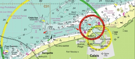
FRANCE - 1. Extensive port developments have taken place within Calais, including a new quay, new lights, buoy removals, changes to coastline and amendments to various limits. The most significant changes are: 2. A new Compulsory Pilotage Limit for the port of Calais has been established, joining the following positions: 50° 59´·36N., 1° 58´·31E. 50° 59´·57N., 1° 58´·23E. 50° 59´·85N., 1° 58´·12E. 51° 00´·70N., 1° 57´·56E. 51° 01´·44N., 1° 56´·41E. 51° 02´·10N., 1° 54´·93E. 51° 02´·38N., 1° 53´·44E. 51° 02´·44N., 1° 52´·30E. 51° 02´·42N., 1° 51´·74E. 51° 02´·38N., 1° 50´·68E. 51° 02´·17N., 1° 49´·11E. 51° 01´·32N., 1° 46´·99E. 51° 00´·86N., 1° 46´·40E. 51° 00´·38N., 1° 45´·88E. 50° 59´·60N., 1° 45´·17E. 50° 58´·84N., 1° 44´·96E. 50° 57´·90N., 1° 44´·90E. 50° 57´·40N., 1° 45´·11E. 50° 57´·01N., 1° 45´·26E. 50° 56´·83N., 1° 45´·37E. 3. The former Compulsory Pilotage Limit has been removed: 50° 59´·29N., 1° 57´·07E. 51° 00´·08N., 1° 56´·79E. 51° 00´·90N., 1° 56´·13E. 51° 01´·66N., 1° 55´·03E. 51° 02´·26N., 1° 53´·23E. 51° 02´·41N., 1° 51´·57E. 51° 02´·38N., 1° 50´·68E. 51° 02´·30N., 1° 50´·10E. 51° 01´·71N., 1° 48´·20E. 51° 00´·67N., 1° 46´·72E. 50° 58´·99N., 1° 46´·00E. 50° 57´·79N., 1° 46´·27E. 50° 57´·25N., 1° 46´·69E. 4. New lights have been established in the following positions Light Designation Position Dir.WRG 50° 58´·92N., 1° 52´·39E. Fl(4)8s Fog Beacon B2 50° 58´·65N., 1° 50´·72E. Fl(2)6s Fog 50° 58´·71N., 1° 52´·08E. Fl(2)6s Fog 50° 58´·73N., 1° 52´·09E. Fl.5s Fog 50° 58´·61N., 1° 52´·06E. 5. The light in position 50° 58´·40N., 1° 50´·46E. has been amended to Q(9)15s12m10M. 6. A dredged area, depth 8·5m, has been established in an area bounded by the following positions 50° 58´·52N., 1° 50´·78E. 50° 58´·62N., 1° 51´·25E. 50° 58´·63N., 1° 51´·66E. 50° 58´·87N., 1° 51´·51E. 50° 58´·83N., 1° 51´·28E. 50° 58´·81N., 1° 51´·21E. 50° 58´·63N., 1° 50´·81E. 50° 58´·62N., 1° 50´·73E. 7. A dredged area, depth 8·0m, has been established in an area bounded by the following positions 50° 58´·71N., 1° 52´·37E. 50° 58´·79N., 1° 52´·39E. 50° 58´·88N., 1° 52´·30E. 50° 58´·88N., 1° 52´·16E. 50° 58´·90N., 1° 51´·81E. 50° 58´·87N., 1° 51´·51E. 50° 58´·63N., 1° 51´·66E. 50° 58´·58N., 1° 51´·94E. 50° 58´·59N., 1° 52´·10E. 8. Mariners are advised to navigate with caution in the area and consult the local port authorities for the latest information. 9. These and other changes will be included in a New Edition of Charts 323, 1351, 1406, 1610, 2449, 1892, 5605_1, 5605_2, 5605_10, 5606_1 and 5605_12 to be published early 2022. Notice 638(P) refers
|
Affects: UKHO Charts: 323, 1351, 1406, 1610, 1892 and 2449 UKHO Small Craft Charts: 5605.1, 5605.10, 5605.12, 5605.2 and 5606.1. Imray Charts: Y9 A significant change of Pilotage area for Calais which has extensively expanded the east side of the ‘old’ port. There are two dredged areas in that expanded area (8m and 8.5m) but as this is for commercial shipping and is quite difficult to illustrate so that is not included. The most relevant change is the light on the eastern arm of the ‘old’ port which is changed from a red light to characteristics (and colour) of a south cardinal light. That is noted on the illustration. The new quay is lit with five lights as indicated (as best possible).
|
|
|
Scroll down for pre- |
|
|
Week 44 |
Admiralty Charts to be published 18 November 2021 ADMIRALTY Small Craft Charts SC5605 Edition 1 Chichester to Ramsgate and Calais to Oostende. 5605_1 A Western Approaches to Dover Strait. 1:500,000: B Northern Approaches to Dover Strait. 1:250,000 5605_2 Dover to Calais. 1:150,000 5605_3 Chichester to Worthing. 1:75,000 5605_4 A Worthing to Newhaven. 1:75,000: Shoreham Harbour Western Arm and River Adur. 1:5,000 5605_5 A Newhaven to Hastings. 1:75,000: B Sovereign Harbour. 1:15,000 5605_6 A Hastings to Dungeness. 1:75,000: B Rye. 1:25,000 5605_7 Dungeness to South Foreland. 1:75,000 5605_8 Dover to Deal. 1:37,500 5605_9 Deal to Ramsgate. 1:37,500 5605_10 Calais to Dunkerque. 1:75,000 5605_11 France and Belgium, Dunkerque to Blankenberge. 1:100,000 5605_12 Ports in France and Belgium. - A France, North Coast Calais. 1:15,000 B France, North Coast Gravelines. 1:20,000 C France, North Coast Dunkerque. 1:20,000 D Belgium, Nieuwpoort. 1:20,000 E Belgium, Oostende. 1:15,000 5605_13 A Newhaven Harbour. 1:5,000 B Littlehampton Harbour. 1:6,250 C Brighton Marina. 1:5,000 D Folkestone Harbour. 1:5,000 5605_14 A Dover. 1:6,250: B Shoreham Harbour Eastern Arm. 1:5,000: C Shoreham Harbour The Canal. 1:5,000 5605_15 Ramsgate and Approaches. - |
One of a series of new Small Craft charts, replacing the Leisure folios. For the convenience of chart users, the number of the withdrawn folio has been retained for these new charts. All sheets have been fully updated for New Editions and Notice to Mariners affecting source charts. |
|
Week 41 |
FRANCE - the accompanying block, centred on: 50° 55´·4N., 1° 49´·3E. limit of marine reserve, (a) 50° 55´·302N., 1° 42´·132E. (b) 50° 55´·433N., 1° 41´·983E. (c) 50° 56´·633N., 1° 44´·167E. (d) 50° 56´·500N., 1° 44´·300E. (e) 50° 56´·496N., 1° 44´·300E. legend, see Note, within: (a)- Notice 4018 refers Base image courtesy of Imray ID10 Chart C8 and Meridian Chartware
|
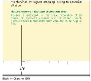
Affects: UKHO Charts: 323, 1351 and 1892 Imray Charts: C8 UKHO Leisure Folios: 5605.2. Imray Leisure Folios: 2100.7 A new marine reserve on the rocky shore under Cap Blanc Nez (wests of Calais).
|
|
Week 40 |
FRANCE - Insert: the accompanying block A, centred on: 50° 57´·9N., 1° 49´·3E. the accompanying block B, centred on: 50° 59´·3N., 1° 52´·4E. the accompanying block C, centred on: 50° 59´·3N., 1° 54´·1E. depth, 1.5, and extend 2m contour N to enclose 50° 56´·827N., 1° 44´·140E. Delete depth, 3.8, close NW. depth, 1.4, and extend 2m contour NW to enclose 50° 56´·557N., 1° 43´·606E. Delete depth, 2.1, close N. depth, 4.1, and extend 5m contour S to enclose 50° 56´·613N., 1° 41´·184E. Notice 3936 refers Base image courtesy of Imray ID10 Chart C8 and Meridian Chartware
|
Affects: UKHO Charts: 1351 Imray Charts: C8 UKHO Leisure Folios: 5605.2, 5605.10 Imray Leisure Folios: 2100.7 Three new UKHO blocks to the east and west of the Calais harbour and three reduced depths – two west of Calais and one at the Le Quenocs NCB. All images are grouped in the download. Each block marked A -
|
|
Week 35 |
New Editions of ADMIRALTY Charts published 02 September 2021 Chart 1872 North Sea , Dunkerque to Vlissingen. 1:100,000 Blankenberge. 1:15,000 This chart is referred to WGS84 Datum. Note: On publication of this New Edition former Notice 428(P)/19 is cancelled. This chart is to be deleted from the list of charts affected by Notice 1495(P)/21. This chart remains affected by Notices 2320(T)/19, 68(T)/21, 430(T)/21, 2167(T)/21 and 2759(T)/21. Chart 1873 International Chart Series, North Sea, Dunkerque to Oostende. 1:60,000 Note: This chart remains affected by Notices 2320(T)/19, 68(T)/21 and 2167(T)/21. Chart 1874 International Chart Series, North Sea, Westerschelde, Oostende to Westkapelle. 1:60,000 A Brugge. 1:15,000 B Zeebrugge Achterhaven. (51° 17’·58 N — 51° 19’·93 N., 3° 11’·40 E — 3° 14’·65 W.) 1:20,000 C Zeebrugge Voorhaven. 1:20,000 This chart is referred to WGS84 Datum. Note: On publication of this New Edition former Notice 428(P)/19 is cancelled. This chart remains affected by Notices 430(T)/21, 2167(T)/21 and 2759(T)21. This chart is to be deleted from the list of charts affected by Notice 1495(P)/21. |
Includes changes to depths and submarine cables. (A modified reproduction of D11 published by Belgium.) Includes changes to depths and buoyage. (A modified reproduction of INT chart 1480 published by Belgium.) Includes changes to depths, submarine cables and limits. A new panel has been included providing improved coverage of Zeebrugge Achterhaven. (A modified reproduction of INT chart 1474 published by the Hydrographic office of Belgium.) This chart is included in the International Chart Series. |
|
Week 35 |
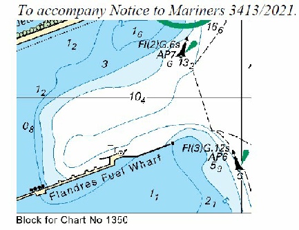
FRANCE - Chart 323 Amend: legend to, Old Lighthouse (29), centred on: 51° 00´·17N., 2° 07´·10E. Chart 1350 Insert: the accompanying block, centred on: 51° 02´·0N., 2° 09´·6E. legend, Quai de Flandre, orientated NW/SE, centred on: 51° 00´·65N., 2° 10´·89E. Amend legend to, Old Lighthouse (29), centred on: 51° 00´·22N., 2° 06´·65E. Notice 3413 refers Base image courtesy of Imray ID10 Chart C2110.2 and Meridian Chartware
|
Affects: UKHO Charts: 323 and 1350 Imray Charts: C2110.2 UKHO Leisure Folios: 5605.2. 5605.10. Imray Leisure Folios: 2110.2 New UKHO block over the Flandres Fuel Wharf in Dunkerque Port Ouest (where we ought not to be!!)
|
|
Week 9 |
New Editions of ADMIRALTY Charts published 04 March 2021 Chart 323 - Note: This chart remains affected by Notices 2320(T)/19, 6186(T)/20 and 68(T)/21. This chart is to be deleted from the list of charts affected by Notice 402(P)/21. 1:75,000 Chart 1350 - Note: This chart is to be deleted from the list of charts affected by Notice 402(P)/21. 1:20,000 Chart 1351 - Calais. 1:7,500 Note: This chart is to be deleted from the list of charts affected by Notice 402(P)/21. Chart 1406 North Sea, Dover and Calais to Orford Ness and Scheveningen. 1:250,000 Note: On publication of this New Edition former Notice 900(P)/21 is cancelled. This chart remains affected by Notices 2320(T)/19, 2741(P)/19, 2927(P)/19, 1196(P)/20, 4079(T)/20, 6186(T)/20 and 67(P)/21. This chart is to be deleted from the list of charts affected by Notice 402(P)/21. |
Includes changes to depths from the latest British Government surveys. Includes significant safety- Includes significant safety- Includes significant safety- |
|
Week 7 |
New Editions of ADMIRALTY Charts published 4th March 2021 Chart 1350 - 1:20,000 Chart 1351 - Calais. 1:7,500 Chart 1406 - |
Includes significant safety- published by France.) Includes significant safety- Includes significant safety- |
|
Week 1 |
FRANCE - A special light- Mariners are advised to navigate with caution in the area. Notice 68(T) refers Base image courtesy of Imray ID10 Chart C30 and Meridian Chartware
|
Affects: UKHO Charts: 323, 1872, 1873 and 2449 Imray Charts: C30 A new special buoy in the Dyck Oriental channel well off Dunkerque. The image includes the new ODAS (‘data collecting buoy Ocean Data Acquisition System of superbuoy size’) reported in Week 47 last year vide NtM 5592. Image is included in Notice 111 further along the list.
|
|
Week 1 |
FRANCE - Insert:
Delete: Automatic Identification System, AIS, at light- Notice 111 refers Base image courtesy of Imray ID10 Chart C30 and Meridian Chartware
|
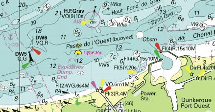
Affects: UKHO Charts: 323, 1406, 1610, 1872, 1873 and 2449 Imray Charts: C30 UKHO Leisure Folios: 5605.10, 5605.11. An eclectic selection of changes: an unsurveyed ‘Foul’ at 19.5m to the west of the Rutingen East North Cardinal, a similar unsurveyed ‘Foul’ at 8.8m in the Dyck Oriental, a ‘Foul’ near to the Banc Breedt (off Dunkerque), a new special buoy close to the buoyed Passe de l’Ouest to Dunkerque and the deletion of the AIS at the ODAS superbuoy.
|
|
2020 Notices for this area below |
||
|
Week 49 |
ENGLAND - Insert:
Base image courtesy of Imray ID10 Chart C8 and Meridian Chartware |
Affects: UKHO Charts: 323, 1610 and 2449 Imray Charts: C8 UKHO Leisure Folios: 5605.2. Imray Leisure Folios: 2100.7 Special Mark west of the NE Goodwin. This notice was first announced as a Temporary Notice (vide 2854(T) in week 24). It is now established as a Permanent Notice.
|
|
Week 49 |
ENGLAND - Replace: depth, 29.5, with depth, 28.5 at 51° 14´·95N., 1° 52´·02E. depth, 27.5, with depth, 27 at 51° 14´·40N., 1° 51´·37E.
Base image courtesy of Imray ID10 Chart C8 and Meridian Chartware |
Affects: UKHO Charts: 323 and 2449 Imray Charts: C8 UKHO Leisure Folios: 5605.2 Imray Leisure Folios: 2100.7 Two changes of depth in the North-
|
|
Week 47 |
FRANCE - Insert
Automatic Identification System, AIS, at the same light-
Base image courtesy of Imray ID10 Chart 2110+2 and Meridian Chartware |
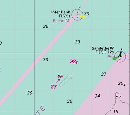
Affects: UKHO Charts: 323, 1406, 1872, 1873 and 2449 Imray Charts: C8, C30 UKHO Leisure Folios: 5605.11. A new ‘data collecting buoy (Ocean Data Acquisition System) of superbuoy size’ in the Binnen Ratel in the offshore banks off Dunkerque.
|
|
Week 40 |
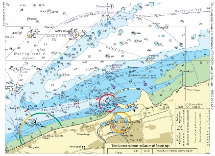
FRANCE - Charts 323 and 1892 Insert the respective accompanying block, centred on: 51° 02´·8N., 1° 50´·1E. Chart 1351 Insert:
limit of anchorage area, pecked line, joining: 51° 01´·00N., 1° 45´·84E. 51° 01´·00N., 1° 46´·10E. 50° 01´·32N., 1° 46´·10E. Delete former limit of anchorage area, pecked line, joining: 51° 01´·00N., 1° 45´·84E. 51° 01´·30N., 1° 45´·84E. 51° 01´·30N., 1° 42´·85E. Charts 1610 and 2449 Insert maritime limit, pecked line, joining: 51° 04´·90N., 1° 50´·00E. 51° 05´·61N., 1° 56´·59E. 51° 04´·23N., 1° 58´·00E. 51° 03´·69N., 1° 51´·81E. Delete former maritime limit, pecked line, joining: 51° 04´·90N., 1° 50´·00E. 51° 04´·90N., 1° 51´·80E. 51° 03´·69N., 1° 51´·81E.
Image is copyright of the UKHO. |
Affects: UKHO Charts: 323, 1351, 1610, 1892 and 2449. Imray Charts: C30 UKHO Leisure Folios: 5605.2. Imray Leisure Folios: 2100.7. This notice provides two UKHO blocks for two specified charts and individual details (as opposed to blocks) on three other charts, all changes dealing with reorganisation of anchor berths and anchorage areas off Calais. The two UKHO blocks are useful (one illustrated, both downloadable via the button).
|
|
Week 33 |
FRANCE - Chart 323 Insert the accompanying block, centred on: 51° 02´·4N., 1° 47´·5E. Chart 1351 Insert:
Delete: Insert:
Chart 1406 Insert:
51° 01´·97N., 1° 44´·48E. 51° 03´·41N., 1° 47´·29E. 51° 00´·71N., 1° 43´·35E. 51° 02´·06N., 1° 47´·58E.
Replace: depth, 24.5, with Chart 1610 Insert the accompanying block, centred on: 51° 02´·5N., 1° 47´·7E. Chart 1892 Insert the accompanying block, centred on: 51° 02´·3N., 1° 47´·2E. Chart 2449 Insert the accompanying block, centred on: 51° 02´·4N., 1° 48´·1E.
The Blocks are copyright of UKHO |
Affects: UKHO Charts: 323, 1351, 1406, 1610, 1892 and 2449 Imray Charts: C1, C8 UKHO Leisure Folios: 5606.1, 5605.2. Imray Leisure Folios: 2100.7. This notice reports a number of obstructions and one FOUL which covers 6 UKHO charts for the Dunkerque Waiting Area off the Ridens of Calais. The changes for 4 of the charts is dealt with by blocks, the remaining 2 charts by individual items. One block is illustrated here. The blocks can be downloaded via the usual button. All items are at over 20m so it is unlikely to hinder leisure craft.
|
|
Week 31 |
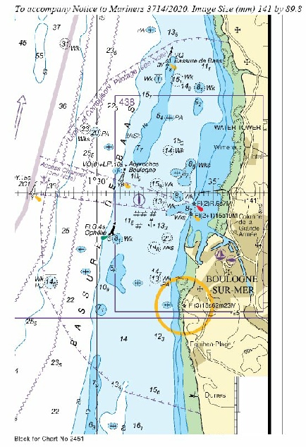
FRANCE - Chart 323 Insert: the accompanying block, centred on: 50° 59´·3N., 1° 50´·4E. the accompanying note, COMPULSORY PILOTAGE, centred on: 50° 55´·93N., 2° 10´·44E. Chart 1351 Insert: the accompanying note, Compulsory pilotage, centred on: 50° 55´·614N., 1° 48´·939E. semi- (a) 50° 56´·867N., 1° 45´·477E. (b) 51° 01´·319N., 1° 47´·425E. and (c) 51° 01´·319N., 1° 53´·493E. (d) 51° 00´·331N., 1° 55´·070E. legend, Limit of Compulsory Pilotage (see Note), along: (a)- Chart 1406 Insert: the accompanying block, centred on: 50° 59´·2N., 1° 50´·4E. the accompanying note, COMPULSORY PILOTAGE, centred on: 50° 51´·31N., 4° 10´·11E. Chart 1610 Insert: the accompanying block, centred on: 50° 59´·4N., 1° 50´·4E. the accompanying note, COMPULSORY PILOTAGE, centred on: 51° 18´·60N., 1° 09´·03E. Chart 2449 Insert: the accompanying block, centred on: 50° 59´·4N., 1° 50´·4E. the accompanying note, COMPULSORY PILOTAGE, centred on: 50° 50´·25N., 3° 14´·03E. limit of restricted area, joining: 50° 48´·34N., 1° 31´·24E. 50° 49´·14N., 1° 33´·34E. 50° 49´·25N., 1° 34´·35E. 50° 49´·10N., 1° 35´·68E. Chart 2451 Insert: the accompanying block, centred on: 50° 44´·1N., 1° 32´·2E. the accompanying note, COMPULSORY PILOTAGE, centred on: 51° 06´·03N., 0° 47´·23E.
Images copyright of the UKHO |
Affects: UKHO Charts: 323, 1351, 1406, 1610, 2449 and 2451 Imray Charts: C8, C30 UKHO Leisure Folios: 5605.2, 5605.10., 5605.12 6.8. Imray Leisure Folios: 2100.7. There are UKHO blocks for 5 charts affecting Calais and Boulogne. The two principal block are shown, all are included in the download.
|
|
Week 25 |
FRANCE - Insert the accompanying block, centred on: 50° 53´·7N., 1° 37´·2E.
The block is copyright of the UKHO. |
Affects: UKHO Charts: 1892 Imray Charts: C8 and 30 UKHO Leisure Folios: 5605.2. Imray Leisure Folios: 2100.7 and 2100.8 A new block for the Banc a la Ligne and coast north-
|
|
Week 4 |
FRANCE - Insert: Chart 323 - Chart 1610 - Chart 2449 - depth, 13.7 at 51° 03´·46N., 2° 11´·45E. Replace:
Delete depth, 4.7, and associated 5m contour 51° 04´·48N., 2° 26´·30E. Move:
Base image courtesy of Imray ID10 Chart C30 and Meridian Chartware |
Affects: UKHO Charts: 323, 1610, 1872, 1873 and 2449 Imray Charts: C30 UKHO Leisure Folios: 5605.2, 5605.10, 5605. An ecletic group of changes – three UKHO blocks for three charts, three reduced depths over wrecks, one reduced depth, one depth completely deleted and one channel buoy moved! The three UKHO blocks cover the Passe d’Ouest (west of Dunkerque). The reduced depths over wrecks, changed depths and buoy move are in the Chenal Intermediaire and Rade de Dunkerque. All images are combined in the PDF download of images Only two UKHO blocks illustrated here.
|
|
Week 4 |
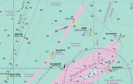
ENGLAND - Insert: depth, 26 at 51° 19´·80N., 1° 54´·82E. Delete depth, 26.5, close N.
Base image courtesy of Imray ID10 Chart C30 and Meridian Chartware |
Affects: UKHO Charts: 323, 1406, 1610 and 2449 Imray Charts: C30 UKHO Leisure Folios: 5605.2, 5606.1 One small reduction of depth in the edge of the SW TSS close south of the F2 special mark. The Imray chart is already correct. At 26m unlikely to hinder leisure craft!
|
|
Week 3 |
New Editions of ADMIRALTY Leisure Folios to be published on 23rd January, 2020 SC 5605 14th Edition - 5605.1 A Western Approaches to Dover Strait. 1:500,000 B Northern Approaches to Dover Strait. 1:250,000 5605.2 Dover to Calais. 1:50,000 5605.3 Chichester to Worthing. 1:75,000 5605.4 A Worthing to Newhaven. 1:75,000 B Shoreham Harbour – Western Arm and River Adur. 1:5,000 5605.5 A Newhaven to Hastings. 1:75,000 B Sovereign Harbour. 1:15,000 5605.6 A Hastings to Dungeness. 1:75,000 B Rye. 1:25,000 5605.7 Dungeness to South Foreland. 1:75,000 5605.8 Dover to Deal. 1:37,500 5605.9 Deal to Ramsgate. 1:37,500 5605.10 Calais to Dunkerque. 1:75,000 5605.11 Dunkerque to Blankenberge. 1:100,000 5605.12 A Calais. 1:15,000 B Gravelines. 1:20,000 C Dunkerque. 1:20,000 D Nieuwpoort. 1:20,000 E Oostende. 1:15,000 5605.13 A Newhaven Harbour. 1:5,000 B Littlehampton Harbour. 1:6,250 C Brighton Marina. 1:5,000 D Folkestone Harbour. 1:5,000 5605.14 A Dover. 1:6,250 B Shoreham Harbour – Eastern Arm. 1:5,000 C Shoreham Harbour – The Canal. 1:5,000 5605.15 A Approaches to Ramsgate. 1:12,500 B Ramsgate. 1:5,000 |
|
|
Week 3 |
ENGLAND - Insert: depth, 20.7 at 51° 12´·51N., 1° 43´·19E. Delete depth, 21, close S or 20.9 there.
Base image courtesy of Imray ID10 Chart C30 and Meridian Chartware |
Affects: UKHO Charts: 323, 1406, 1610 and 2449 Imray Charts: C30 UKHO Leisure Folios: 5605.1, 5605.2, 5606.1, 5606.3 Imray Leisure Folios: 2100.7. One isolated reduced depths in the SW bound TSS south of the Tail of the Falls.
|
|
Week 3 |
ENGLAND - Replace: depth, 29, with depth, 28.5 at 51° 20´·23N., 1° 52´·18E.
Base image courtesy of Imray ID10 Chart C30 and Meridian Chartware |
Affects: UKHO Charts: 323, 1406, 1610 and 2449 Imray Charts: C1, C8, C30 UKHO Leisure Folios: 5605.1, One reduction of depth in the SW TSS in the Mid Falls. At 29m I do not think this will hinder leisure craft!
|


 with
with  at 50° 48´·11N., 1° 19´·95E.
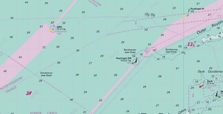

 Fl(5)Y.20s GEOCEAN ODAS
  Fl(4)Y.15s POG
  Fl(3)G.12s DW17
 Fl.R.4s DW20

 Fl(5)Y.20s ODAS EOLOS
 Dragage Braek


 , joining:
 at 51° 02´·71N., 2° 17´·16E.


 , joining:
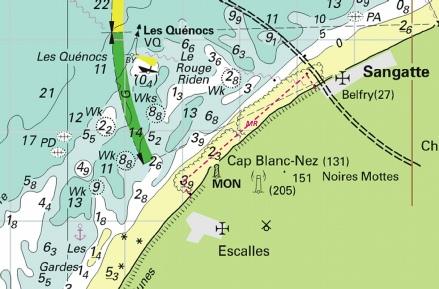
 at 51° 14´·94N., 2° 16´·53E.
 at 51° 10´·88N., 2° 21´·40E.
 Obstn
Obstn  Fl(5)Y.20s
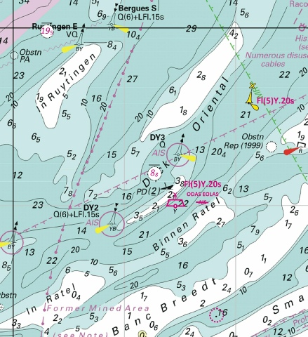
 Fl.Y.5s
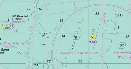
 Fl(5)Y.20s ODAS EOLOS
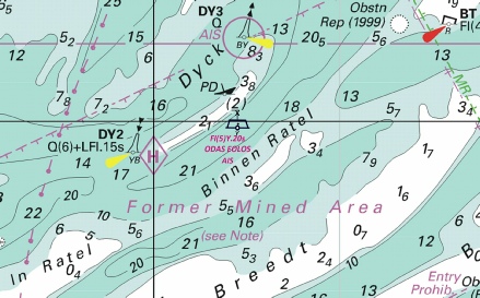
 SW, centred on: 51° 01´·00N., 1° 43´·80E.
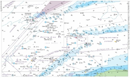
 Obstns
 at 51° 01´·25N., 1° 45´·48E.
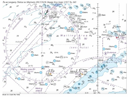
 Wk
Wk 
 Wk
Wk 
 Wk
Wk 
 Fl.R.4s DW20