|
Notices - |
||
|
Week 17 |
ENGLAND - Insert: depth, 1 , and extend 2m approximate contour E to enclose 51° 42´·46N., 1° 33´·17E. depth, 0.9 , and extend 2m approximate contour SE to enclose 51° 42´·16N., 1° 32´·86E. depth, 1.1, and extend 2m approximate contour S to enclose 51° 41´·93N., 1° 32´·42E. Delete depth, 3.5, close SW. depth, 0.1 , enclosed by 2m contour 51° 36´·42N., 1° 35´·15E. Delete depth, 5.2, close SE. depth, 0.9 , enclosed by 2m contour 51° 36´·17N., 1° 34´·69E. Delete depth, 8.1, close SW. depth, 0.7 , enclosed by 2m contour 51° 36´·49N., 1° 35´·44E. Notice 1880 refers Base image courtesy of Imray ID10 Chart C1 and Meridian Chartware.
|
Affects: UKHO SNC: 1183, 1607 and 1975. UKHO SCC: 5607.2. Imray Full Charts: C1 Imray Leisure Folios 2000.1 Six reductions of depth, three on the Long Sand and three on the Kentish Knock. The soundings on the Long Sand are outside the Wind Farm to the NE. The three on the Kentish Knock are just outside the south side of the Wind Farm and quite dramatic: i.e. fro8.1m to 0.9. But probably not where we usually go.
|
|
Week 16 |
ENGLAND - Insert: depth, 2.2 at 51° 47´·88N., 1° 37´·22E. Delete depth, 4.5, close NE. depth, 6.9 at 51° 48´·09N., 1° 37´·87E. depth, 11 at 51° 48´·26N., 1° 38´·16E. Notice 1784 refers Base image courtesy of Imray ID10 Chart C1 and Meridian Chartware.
|
Affects: UKHO SNC: 2692. UKHO SCC: 5607.2. Imray Full Charts: C1 Imray Leisure Folios 2000.1 Three new reduced depths for SNC 2692 at the Long Sand Head. A new edition of SNC 2692 was only issued on 28th March! The reduced depths indicate that the Long Sand Head continues the common trend to extend to the NE. I understand it is likely the Long Sand Head North Cardinal which is critical marking the tight corner in the two-
|
|
Week 15 |
ENGLAND - Insert: depth, 16.3 at 51° 51´·20N., 1° 36´·22E. Delete depth, 17.1, close E. depth, 16.6 at 51° 51´·12N., 1° 36´·57E. Delete depth, 17.1, close NW. Notice 1597 refers Base image courtesy of Imray ID10 Chart C1 and Meridian Chartware.
|
Affects: UKHO SNC: 1183 and 1975. Note: This update is included in New Edition 2692, published 28 March 2024. UKHO SCC: 5607.2 Imray Full Charts: C1 Imray Leisure Folios 2000.1 Two reductions of depth; this monitoring the DW channel on the Sunk Inner area. Unlikely to hinder leisure craft. The image includes a reduced depth vide NtM 1470 previously.
|
|
Week 15 |
ENGLAND - Insert: depth, 2.7, and extend 5m contour S to enclose 51° 32´·43N., 1° 01´·64E. Delete depth, 4, close NW. depth, 6.2 at 51° 32´·53N., 1° 01´·95E. Delete depth, 6.7, close SW depth, 2.7 at 51° 32´·44N., 1° 01´·60E. Delete depth, 4, close SE. depth, 5.5 at 51° 32´·34N., 1° 01´·23E. Delete depth, 7.2, close SW. depth, 6.1 at 51° 32´·21N., 1° 00´·75E. Delete depth, 7, close E. Replace: depth, 6.5, with depth, 6 at 51° 32´·65N., 1° 02´·22E. depth, 9.1, with depth, 8.6 at 51° 32´·38N., 1° 01´·58E. depth, 1.7, with depth, 1.2, and extend 2m approximate contour S to enclose 51° 32´·43N., 1° 01´·51E. depth, 4.4, with depth, 2.7, and extend 5m contour S to enclose 51° 32´·40N., 1° 01´·47E. Notice 1608 refers Base image courtesy of Imray ID10 Chart IN5043 and Meridian Chartware.
|
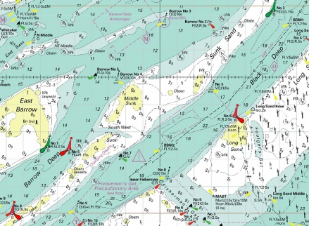
Affects: UKHO SNC: 1607 and 1609. UKHO SCC: 5606.6 Imray Full Charts: C1 Imray Leisure Folios 2100.1 Nine reductions of depth at the Mouse channel side of the SW Barrow knoll. If you are a ‘corner cutter’ round the knoll (e.g. to or from the Princes Channel into the West Swin) it is worth seeing the image. Note the edge of that sand is pretty ‘steep-
|
|
Week 14 |
ENGLAND - Insert: depth, 15.8 at 51° 51´·50N., 1° 36´·12E. Delete depth, 16.2, close SE. Notice 1470 refers Base image courtesy of Imray ID10 Chart C1 and Meridian Chartware.
|
Affects: UKHO SNC: 1975. Note: This update is included in New Edition 2692, published 28 March 2024. UKHO SCC: 5607.2 Imray Full Charts: C1 Imray Leisure Folios 2000.1 One reduction of depth NE of the Sunk Inner Mark in line with the DW channel leading to the exit to Felixstowe. Unlikely to hinder leisure craft.
|
|
Week 13 |
ENGLAND - Insert: depth, 9.9, enclosed by 10m contour at 51° 48´·42N., 1° 39´·17E. Delete depth, 10.7, close NW and depth, 10.3, close NW. depth, 10.2 at 51° 48´·63N., 1° 39´·41E. Delete depth, 11.1, close NW and depth, 10.7, close W. depth, 14, enclosed by 15m contour at 51° 49´·84N., 1° 36´·46E. Delete depth, 15.9, close W. Replace: depth, 10.1, with depth, 9.4, enclosed by 10m contour 51° 50´·02N., 1° 35´·82E. Notice 1378 refers Base image courtesy of Imray ID10 Chart C1 and Meridian Chartware.
|
Affects: UKHO SNC: 1183, 1610 and 1975. Note: This update is included in New Edition 2692, published 28 March 2024. UKHO SCC: 5607.2 Imray Full Charts: C1 Imray Leisure Folios 2000.1 A reduction of depth, three of which are in the ‘turn’ of the Long Sand Head two-
|
|
Week 13 |
ENGLAND - Amend: Sunk Centre light- Notice 1433 refers Base image courtesy of Imray ID10 Chart C1 and Meridian Chartware.
|
Affects: UKHO SNC: 1183. UKHO SCC: 5606.2 and 5607.2 Imray Full Charts: C1 This notice applies only to the small scale chart of the whole Thames Estuary (SNC 1183). The change is the light characteristics of the Sunk Centre safe water buoy. I believe most charts are all ready correct.
|
|
Week 12 |
ENGLAND - Insert: depth, 8 at 51° 36´·23N., 1° 20´·53E. Delete depth, 8.3, close SW. depth, 8.2 at 51° 36´·12N., 1° 20´·28E. Delete depth, 8.6, close NE. depth, 4.9, and extend 5m approximate contour NE to enclose 51° 35´·50N., 1° 20´·82E. depth, 6.2 at 51° 35´·24N., 1° 21´·21E. Delete depth, 7.1, close SW. depth, 6.3 at 51° 35´·09N., 1° 21´·44E. Delete depth, 6.9, close SW. depth, 5.5 at 51° 35´·57N., 1° 20´·74E. Delete depth, 6.7, close NW. Replace: depth, 9.5, with depth, 9 at 51° 35´·67N., 1° 20´·74E. Notice 1222 refers Base image courtesy of Imray ID10 Chart IN5043 and Meridian Chartware.
|
Affects: UKHO SNC: 1606, 1607 and 1975. UKHO SCC: 5606.2 and 5607.2 Imray Full Charts: C1 Imray Leisure Folios 2100.1 and 2000.1 7 reduction of depth in Fisherman’s Gat. Still ample water for leisure craft and still just outside the west side of the buoyage. But note there is a just the suggestion that the drying patch of the Long Sand on the mid-
|
|
Week 12 |
ENGLAND - Insert: depth, 9 at 51° 53´·03N., 1° 31´·00E. Delete depth, 9.9, close NW. Notice 1304 refers Base image courtesy of Imray ID10 Chart C1 and Meridian Chartware.
|
Affects: UKHO SNC: 1183. Note: This update is included in New Edition 2692, published 28 March 2024. UKHO SCC: 5607.2 Imray Full Charts: C1 Imray Leisure Folios: 2000.1 One reduction of depth on the east edges of the Roughs Shoals. At 9m, unlikely to hinder leisure craft.
|
|
Week 11 |
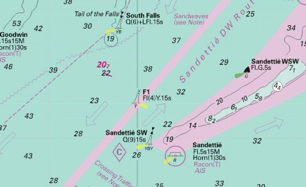
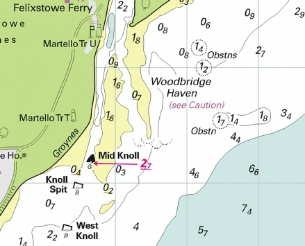
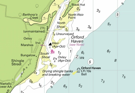
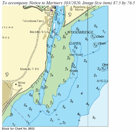
New Editions of ADMIRALTY Charts on 28th March, 2024 Standard National Charts Chart 2692 England - Small Craft Charts SCC 5605.8 Dover to Deal. 1:37,500 SCC 5605.9 Deal to Ramsgate. 1:37,500 SCC 5607.4 Southern Approaches to Harwich. 1:50,000 SCC 5607.5 Harwich to Orford Ness. 1:50,000 SCC 5607.6 A Approaches to Harwich and Woodbridge Haven. 1:25,000 B Continuation of River Deben. 1:25,000 SCC 5607.7 Rivers Stour and Orwell. A River Stour. 1:25,000 B River Orwell. 1:25,000 C Ipswich. 1:10,000 SCC 5607.8 A Rivers Ore and Alde. 1:25,000 B Orford Haven and Approaches. 1:25,000 |
Includes changes to depths from the latest British Government and Port of London Authority surveys. Includes full updates for New Edition and Notices to Mariners affecting source charts. |
|
Week 10 |
ENGLAND - Insert: depth, 2.4 at 51° 42´·05N., 1° 25´·32E. Delete depth, 3.9, close N. depth, 0.7 at 51° 41´·83N., 1° 25´·65E. Delete depth, 0.9, close SW. depth 4.6, and extend 5m contour NW to enclose 51° 41´·75N., 1° 23´·95E. Delete depth, 6.7, close W. depth, 2.9 at 51° 41´·18N., 1° 24´·13E. Delete depth, 3.1, close SE. Notice 1026 refers Base image courtesy of Imray ID10 Chart IN5043 and Meridian Chartware.
|
Affects: UKHO SNC: 1183 and 1975. UKHO SCC: 5606.2 and 5607.2 Imray Full Charts: C1 Imray Leisure Folios 2100.1 and 2000.1 Four reductions of depth on the Little Sunk, two of which are on the usual crossing point and two indicating a slight growth of the Little Sunk knoll. This change is caused by our 2023 survey and the crossing point is NOT significantly affected. At the moment the growth of the Little Sunk appears to be quite slow, indeed the worse depth of 0.7m looked like the ‘crest’ of a sand wave.
|
|
Week 08 |
ENGLAND - Insert depth, 15.7 at 51° 48´·91N., 1° 33´·34E. Delete depth, 16, close NE. Notice 769 refers Base image courtesy of Imray ID10 Chart C1 and Meridian Chartware.
|
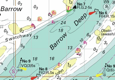
Affects: UKHO SNC: 2692 UKHO SCC: 5607.1 Imray Full Charts: C1 Imray Leisure Folios: 2100.1 One slight reduction of depth right on the line of the Sunk/Black Deep deep water channel. Obviously the PLA monitors the depth of that channel rigorously. At 15.7m unlikely to hinder leisure craft but don’t linger!
|
|
Week 07 |
ENGLAND - Insert: depth, 4, and extend 5m contour SE to enclose 51° 32´·43N., 1° 01´·61E. Notice 638 refers Base image courtesy of Imray ID10 Chart IN5043 and Meridian Chartware.
|
Affects: UKHO SNC: 1607 and 1609 UKHO SCC: 5606.6 Imray Full Charts: C1 Imray Leisure Folios: 2100.1 One reduction of depth in the Mouse Channel east of the SW Barrow cardinal buoy. Unlikely to hinder leisure craft. The Image also includes the detail of NtM 335 regarding the new ‘obstn’ west of the ‘Alice’ Danger mark.
|
|
Week 05 |
ENGLAND - Insert:
Notice 447 refers Base image courtesy of Imray ID10 Chart IN5043 and Meridian Chartware.
|
Affects: UKHO SNC: 1607 and 1609 UKHO SCC: 5606.5 Imray Full Charts: C1 Imray Leisure Folios: 2100.1 This is a catch-
|
|
Week 04 |
ENGLAND - Insert:
Notice 335 refers Base image courtesy of Imray ID10 Chart IN5043 and Meridian Chartware.
|
Affects: UKHO SNC: 1607 and 1609 UKHO SCC: 5606.6 and 5606.2 Imray Full Charts: C1 Imray Leisure Folios: 2100.1 A new ‘obstn’ in the Mouse Channel east of the SW Barrow west cardinal buoy and west of the ‘Alice’ danger buoy. Adjacent to the new ‘obstn’ are three unlit Orange buoys; all these close to an existing lit yellow special buoy.
|
|
Week 03 |
ENGLAND - Insert: depth, 4.3, and extend 5m contour N to enclose 51° 33´·27N., 1° 17´·39E. Delete depth, 6.3, close NW. depth, 7.9 at 51° 33´·34N., 1° 18´·34E. Delete depth, 8.4, close SW. depth, 6.8 at 51° 33´·24N., 1° 19´·27E. Delete depth, 7.7, close SW. depth, 6 at 51° 33´·16N., 1° 19´·61E. Delete depth, 7.3, close SE. Replace: depth, 8, with depth, 7.3 at 51° 32´·98N., 1° 20´·25E. Notice 196 refers Base image courtesy of Imray ID10 Chart IN5036 and Meridian Chartware.
|
Affects: UKHO SNC: 1183, 1606 and 1607 UKHO SCC: 5606.6 and 5606.2 Imray Full Charts: C1 Imray Leisure Folios: 2100.1 5 reductions of depth in the North Edinburgh Channel. None of the reductions are likely to hinder leisure craft and if that is all affecting the North Edinburgh channel it is logical that the Channel remains as it used to be. No buoyage of course.
|
|
Week 01 |
ENGLAND - Note: This update is included in New Edition 2052, published 28 December 2023. Insert: depth, 15.2 at 51° 48´·78N., 1° 37´·39E. Delete depth, 16.3, close NW. Notice 29 refers Base image courtesy of Imray ID10 Chart C1 and Meridian Chartware.
|
Affects: UKHO SNC: 1975 and 2692 UKHO SCC: 5607.2 Imray Full Charts: C1 Imray Leisure Folios: 2000.1 and 2100.1 One reduction of depth in the Long Sand Head two-
|
|
SCROLL DOWN FOR PRE- |
||
|
Week 51 |
ENGLAND - Insert :
Replace: depth, 11.9, with depth, 11.8 at 51° 41´·24N., 1° 17´·59E. Notice 4832 refers Base image courtesy of Imray ID10 Chart IN5043 and Meridian Chartware.
|
Affects: UKHO SNC: 1183 and 1975 UKHO SCC: 5606.6 and 5607.2 Imray Full Charts: C1 Imray Leisure Folios: 2000.1 One new wreck and one new depth in the Barrow Deep. Both will be unlikely to hinder any leisure craft but note that the wreck is in the corner of the Barrow Deep Anchorage!
|
|
Week 47 |
ENGLAND - Amend: legend to, Dredged to 16·0m, centred on: 51° 55´·91N., 1° 25´·29E. legend to, 16·0m, centred on: 51° 53´·09N., 1° 33´·61E. Insert limit of dredged channel, pecked line, joining: 51° 52´·37N., 1° 33´·16E. 51° 52´·24N., 1° 33´·20E. Delete former limit of dredged channel, pecked line, joining: 51° 52´·37N., 1° 33´·16E. 51° 52´·24N., 1° 33´·14E. legend, Channel Deepening (see Note), centred on: 51° 56´·36N., 1° 31´·25E. 51° 52´·93N., 1° 33´·60E. Notice 4352 refers Base image courtesy of Imray ID10 Chart C1 and Meridian Chartware.
|
Affects: UKHO SNC: 1183, 1610 and 2692 UKHO SCC: 5607.2. Imray Full Charts: C1 and Y16 This notice changes the depth of the dredged channel from the Sunk to and into Felixstowe to an increased 16m and extends the marked channel to extend south right up to the S. Threshold yellow special lit buoy.
|
|
Week 42 |
ENGLAND - Insert: depth, 7.9 at 51° 29´·33N., 1° 09´·19E. Notice 3764 refers Base image courtesy of Imray ID10 Charts IN5043 and Meridian Chartware.
|
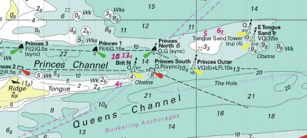
Affects: UKHO SNC: 1606, 1607 and 1609 UKHO SCC: 5606.2 Imray Full Charts: Y16 Imray Leisure Charts: 2100.1 One reduction of depth right in the middle of the Princes Channel north of the Princes Mid yellow special lit buoy. Not where you need to be and unlikely to hinder leisure craft.
|
|
Week 35 |
ENGLAND - The Sunk Inner light- Mariners are advised to navigate with caution in the area. Notice 2977(T) refers Base image courtesy of Imray ID10 Charts C1 and Meridian Chartware.
|
Affects: UKHO SNC: 1183, 1406, 1408, 1610, 1975, 2052, 2182A and 2692. UKHO SCC: 5607.1, 5607.2 and 5614.25 Imray Full Charts: C1 Imray Leisure Charts: 2000.1 A temporary notice reporting a short term replacement for the Inner Sunk safe water mark. The light float is removed for service and has a safe water buoy with different light characteristics substituted. Last I saw the light float on the Shotley TH mooring.
|
|
Week 31 |
EAST COAST OF ENGLAND - The following buoys have been returned to their assigned positions: Walker Lighted Buoy Moved back to assigned position: Latitude 51° 53.791’N., Longitude 001° 33.903’E. Southwest Shipwash Lighted Buoy Moved back to assigned position: Latitude 51° 54.750’N., Longitude 001° 34.213’E. Trinity House Notice to Mariners 12/2023, dated 3rd April 2023, is hereby cancelled. Trinity House No 20 of 2023 refers
|
Affects: UKHO SNC: 2052 UKHO SCC: 5607.1 and 5607.2 Imray Full Charts: C1 Imray Leisure Charts: 2000.1 The temporary movement of the Walter and Southwest Shipwash lighted buoys to facility the dredging working for the Deep Water Channel from the Sunk to Felixstowe is now cancelled and the buoys back to their normal charted positions. No image. |
|
Week 30 |
New Editions of ADMIRALTY Charts to be published 10 August 2023 Chart 1606 - Chart 1607 - Chart 1609 England - |
Includes significant safety- |
|
Week 26 |
New Editions of ADMIRALTY Charts to be published 13 July 2023 SNC 1975 England - |
Includes changes to depths from the latest Port of London Authority and Trinity House surveys. |
|
Week 26 |
ENGLAND - Insert: drying height, 0.4, and extend 0m approximate low water line N to enclose 51° 38´·43N., 1° 24´·35E. drying height, 0.3, and extend 0m low water line NW to enclose 51° 42´·32N., 1° 30´·32E. Delete:
Notice 2189 refers Base image courtesy of Imray ID10 Chart ON5043 and Meridian Chartware.
|
Affects: UKHO SCC: 5606.2 and 5607.2 Imray Full Charts: C1 Imray Leisure Charts: 2100.1 and 2000.1. This notice is including two new drying heights and a deletion of a wreck that were reported in NtM 1798 in Week 22. These new drying heights are both on the Long Sand and are included to update two UKHO small craft charts. I am repeating what I said in week 22: “Three new drying areas around the Black Deep: one on Long Sand at the edge of the Black Deep No 6 port hand buoy, a second, a drying area, on the Long Sand near the Black Deep No 4 close to the old Beacon, the third, again on the Long Sand where a wreck was once marked at 3.2m. On the Little Sunk a depth is reduced to 0.9m which formerly was marked close by as 1.8m. That does not affect the Little Sunk ‘crossing’ but suggests it is worth a re-
|
|
Week 22 |
ENGLAND - Insert: drying height, 0.4, and extend 0m approximate low water line N to enclose 51° 38´·43N., 1° 24´·35E. drying height, 0.3, and extend 0m low water line NW to enclose 51° 42´·32N., 1° 30´·32E. depth, 0.9, and extend 2m contour S to enclose 51° 41´·77N., 1° 25´·57E. Delete depth, 1.8, close NE. circular limit of 0m low water line, radius 60m, centred on: (b) 51° 41´·65N., 1° 29´·46E. legend, Dries, close W of: (b) above Replace: depth, 15.9, with depth, 15.8 at 51° 44´·93N., 1° 30´·63E. Delete:
Notice 1798 refers Base image courtesy of Imray ID10 Chart IN5043 and Meridian Chartware.
|
Affects: UKHO SNC: 1183, 1975 and 2692 UKHO SCC: 5606.2 and 5607.2 Imray Full Charts: C1 Imray Leisure Charts: 2100.1 and 2000.1. Three new drying areas around the Black Deep: one on Long Sand at the edge of the Black Deep No 6 port hand buoy, a second, a drying area, on the Long Sand near the Black Deep No 4 close to the old Beacon, the third, again on the Long Sand where a wreck was once marked at 3.2m. On the Little Sunk a depth is reduced to 0.9m which formerly was marked close by as 1.8m. That does not affect the Little Sunk ‘crossing’ but suggests it is worth a re- Finally there is a tiny reduction of 0.1m in the centre of the Black Deep deep water channel.
|
|
Week 22 |
ENGLAND - 1. Secondary Channels have been established adjacent to the main Knock John Channel. 2. A Northern Inbound channel has been established in an area bounded by the following positions: 51° 33´·79N., 1° 10´·75E. 51° 33´·71N., 1° 10´·85E. 51° 33´·50N., 1° 10´·29E. 51° 33´·42N., 1° 10´·10E. 51° 33´·08N., 1° 09´·24E. 51° 33´·06N., 1° 09´·20E. 51° 33´·01N., 1° 09´·07E. 51° 33´·00N., 1° 09´·05E. 51° 32´·99N., 1° 09´·03E. 51° 32´·87N., 1° 08´·72E. 51° 32´·47N., 1° 07´·74E. 51° 32´·47N., 1° 07´·73E. 51° 32´·14N., 1° 06´·93E. 51° 32´·08N., 1° 06´·77E. 51° 32´·06N., 1° 06´·72E. 51° 32´·14N., 1° 06´·63E. 51° 33´·52N., 1° 10´·05E. 3. A Southern Outbound channel has been established in an area bounded by the following positions: 51° 33´·50N., 1° 11´·11E. 51° 33´·26N., 1° 10´·45E. 51° 31´·85N., 1° 06´·98E. 51° 31´·93N., 1° 06´·88E. 51° 32´·14N., 1° 07´·40E. 51° 32´·39N., 1° 08´·02E. 51° 32´·41N., 1° 08´·07E. 51° 32´·57N., 1° 08´·47E. 51° 32´·59N., 1° 08´·52E. 51° 32´·70N., 1° 08´·80E. 51° 32´·72N., 1° 08´·84E. 51° 32´·83N., 1° 09´·10E. 51° 32´·91N., 1° 09´·31E. 51° 32´·96N., 1° 09´·43E. 51° 32´·96N., 1° 09´·43E. 51° 32´·97N., 1° 09´·44E. 51° 32´·99N., 1° 09´·49E. 51° 33´·33N., 1° 10´·35E. 51° 33´·58N., 1° 11´·01E. 4. The minimum depth within the new secondary channels is 9m and vessels which can safely navigate outside of the main Knock John Channel should do so. 5. Mariners are advised to navigate with caution in the area and consult the local port authorities for the latest information. 6. These changes will be included in New Edition of Charts 1606, 1607 and 1609 to be published mid 2023. Notice 1830(P) refers Base image courtesy of Imray ID10 Chart IN5043 and Meridian Chartware.
|
Affects: UKHO SNC: 1606, 1607 and 1609 UKHO SCC: 5606.2 Imray Full Charts: C1 Imray Leisure Charts: 2100.1. The Port of London Authority has established two secondary channels either side of the existing established Knock John Channel. These secondary channels alongside from the Knock John port hand buoy ‘paired’ with the Knock John No 1 south cardinal buoy to the Knock John No 7. The secondary channels have a minimum depth of 9m and vessels which can safely navigate outside of the main Knock John Channel should us it rather than the established Channel. Note that the northern side of the Knock John are for inbound vessels and the southern side for outbound vessels.
|
|
Week 21 |
ENGLAND - Insert: depth, 4.4, and extend 5m contour S to enclose 51° 32´·40N., 1° 01´·46E. Notice 1752 refers Base image courtesy of Imray ID10 Chart IN5043 and Meridian Chartware.
|
Affects: UKHO SNC: 1607 and 1609 UKHO SCC: 5606.2 Imray Full Charts: C1 Imray Leisure Charts: 2100.1. One reduction of depth on the tail of the SW Barrow sands. At 4.4m unlikely to hinder leisure craft.
|
|
Week 20 |
ENGLAND - Insert: depth, 1.8, enclosed by 2m contour at 51° 31´·70N., 1° 13´·71E. Delete depth, 5.6, close W and depth, 7.8, close SE. depth, 1, and extend 2m contour S to enclose 51° 31´·86N., 1° 14´·91E. Delete depth, 2.5, close N. depth, 6 at 51° 31´·26N., 1° 15´·62E. Delete depth, 9.6, close E. depth, 0.6, and extend 2m approximate contour S to enclose 51° 32´·00N., 1° 14´·63E. depth, 2.3 at 51° 31´·68N., 1° 15´·12E. depth, 4.8, enclosed by 5m contour at 51° 31´·44N., 1° 15´·29E. Delete depth, 7.5, close SW. depth, 3.9, and extend 5m contour SW to enclose 51° 31´·57N., 1° 14´·18E. Delete depth, 5.7, close NE. depth, 4.3, enclosed by 5m contour at 51° 31´·58N., 1° 13´·81E. Delete depth, 7.8, close NE. depth, 3.6, and extend 5m approximate contour SW to enclose 51° 31´·76N., 1° 13´·15E. Delete depth, 7.1, close SE. depth, 4.6, and extend 5m approximate contour SW to enclose 51° 31´·85N., 1° 12´·84E. Notice 1670 refers Base image courtesy of Imray ID10 Chart IN5043 and Meridian Chartware.
|
Affects: UKHO SNC: 1183, 1606 and 1607 UKHO SCC: 5606.5 and 5606.6 Note: This update is included in the New Edition 5606_2, published 25 May 2023. Imray Full Charts: C1 Imray Leisure Charts: 2100.2 Ten reductions of depth in the South Edinburgh Channel. Still feasible but of course not ‘buoyed’.
|
|
Week 16 |
ENGLAND - Insert: depth, 13.3 at 51° 29´·40N., 0° 52´·43E. Delete depth, 13.4, close E. depth, 14.2, and extend 15m contour S to enclose 51° 31´·81N., 1° 05´·74E. depth, 15, and extend 15m contour SE to enclose 51° 32´·43N., 1° 07´·70E. Delete depth, 15.2, close SW. depth, 14.4 at 51° 32´·37N., 1° 07´·72E. Delete depth, 14.6, close S. depth 8.1 at 51° 29´·49N., 1° 07´·63E. Delete depth, 8.4, close W and depth 8.3 close E. depth 7.2 at 51° 29´·38N., 1° 06´·75E. Delete depth, 7.3, close E and depth, 5.8, close SE. depth, 12.6 at 51° 29´·09N., 0° 54´·89E. Delete depth, 11.4, close N. depth, 13 at 51° 31´·51N., 1° 04´·56E. Delete depth, 15.9, close E. Replace: depth, 15.5, with depth, 15.4 at 51° 32´·08N., 1° 07´·20E. depth, 14.7, with depth, 14.5 at 51° 32´·48N., 1° 08´·01E. depth, 7.9, with depth, 7.8 at 51° 29´·36N., 1° 07´·63E. Notice 1358 refers Base image courtesy of Imray ID10 Chart IN5043 and Meridian Chartware.
|
Affects: UKHO SNC: 1185, 1606, 1607 and 1609 UKHO SCC: 5606.7, 5606.9 and 5606.5 Imray Full Charts: C1 Imray Leisure Charts: 2100.1 and 2100.2 11 reductions of depth, 2 around the sea Reach No 1 area and West Oaze, 3 around the Princes Nos 6 and 7 buoys and 6 in the Mouse and Knock John Channels. All unlikely to hinder leisure craft.
|
|
Week 9 |
ENGLAND - Insert depth, 13.5 at 51° 33´·11N., 1° 09´·78E. Delete depth, 13, close S and SW. depth, 14.2 at 51° 33´·17N., 1° 09´·78E. depth, 13.5 at 51° 33´·23N., 1° 10´·05E. Delete depth, 13.6, close W and delete depth, 13.6, close W. Replace depth, 13.9, with depth, 13.7 at 51° 33´·19N., 1° 09´·55E. Notice 813 refers Base image courtesy of Imray ID10 Chart IN5043 and Meridian Chartware.
|
Affects: UKHO SNC: 1606, 1607 and 1609 UKHO SCC: 5606.6 Imray Full Charts: C1 Imray Leisure Folios: 2100.1 An extraordinary tight cluster of 4 reductions of depth around the Knock John Buoys Nos 2 and 3. Not likely to hinder leisure craft but clearly is tight at LWS for big container ships there!
|
|
Week 8 |
ENGLAND - Insert depth, 10.3 at 51° 48´·45N., 1° 39´·13E. Delete depth, 10.7, close NW. depth, 10.7 at 51° 48´·63N., 1° 39´·37E. Delete depth, 11.1, close NW. Notice 738 refers Base image courtesy of Imray ID10 Chart C1 and Meridian Chartware.
|
Affects: UKHO SNC: 1975 and 2052 Imray Full Charts: C1 Imray Leisure Folios: 2100.1 and 2000.1 Two additional reductions of depth at the Long Sand Head in the ship’s Two-
|
|
Week 7 |
ENGLAND - Insert: depth, 7.3 at 51° 29´·40N., 1° 06´·34E. Delete depth, 6.1, close S. depth, 7.3 at 51° 29´·37N., 1° 06´·77E. Replace: depth, 7.4, with depth, 7.6 at 51° 29´·60N., 1° 07´·04E. Notice 589 refers Base image courtesy of Imray ID10 Chart IN5043 and Meridian Chartware.
|
Affects: UKHO SNC: 1606, 1607 and 1609 UKHO SCC: 5606.2 and 5606.5 Imray Full Charts: C1 Imray Leisure Folios: 2100.1 and 2100.2 Two very slight reductions of depth in the centre of the Deep Water line of the Princes Channel abaft the Princes No 6 PHB and one reduction at the Princes No 7 SHB. Unlikely to hinder leisure craft and unlikely where we ought to be!
|
|
Week 7 |
ENGLAND - Insert: depth, 15.7 at 51° 51´·93N., 1° 35´·74E. Delete depth, 16.7, close W. 15.2 at 51° 51´·73N., 1° 35´·47E. Delete depth, 15.7, close NW. depth, 14.5, enclosed by 15m contour at 51° 50´·75N., 1° 33´·52E. Delete depth, 15.7, close SE. Notice 636 refers Base image courtesy of Imray ID10 Chart C1 and Meridian Chartware.
|
Affects: UKHO SNC: 2692 UKHO SCC: 5607.2 Imray Full Charts: C1 Imray Leisure Folios: 2100.1 and 2000.1 Three reduction of depth in and around the Sunk Inner Precautionary Area. Unlikely to hinder leisure craft.
|
|
Week 5 |
ENGLAND - Note: This update is included in New Edition 1975, published 19 January 2023. Insert: depth, 7.9, and extend 10m contour NE to enclose 51° 48´·16N., 1° 38´·19E. Delete depth, 8.4, or 9.2 close SW or 9.3 close W, depending on which chart to correct. sounding out of position, 16. at 51° 48´·34N., 1° 36´·94E. Delete depth, 17.9, close SE. (the sounding is at the Black Deep port hand buoy, hence ‘out of position) depth, 15.9 at 51° 48´·29N., 1° 37´·44E. Delete depth, 17.5, close W. depth, 12.1 at 51° 48´·24N., 1° 38´·33E. Delete depth, 12.9, close S. depth, 10.7 at 51° 48´·14N., 1° 38´·89E. Delete depth, 11.4, close N. depth, 14.4, and extend 15m contour E to enclose 51° 48´·13N., 1° 39´·52E. depth, 11.4 at 51° 48´·09N., 1° 39´·21E. Delete depth, 13.4, close SE. depth, 10.8 at 51° 48´·11N., 1° 38´·46E. Delete depth, 11.8, close SW. depth, 6.7 at 51° 48´·05N., 1° 37´·97E. Delete depth, 8.8, close SE. depth, 4.9, and extend 5m contour NE to enclose 51° 47´·99N., 1° 37´·72E. Delete depth, 7.1, close NE. depth, 6.3 at 51° 47´·98N., 1° 37´·49E. Delete depth, 6.7, close E. depth, 9.2, and extend 10m contour N to enclose 51° 48´·10N., 1° 37´·79E. Delete depth, 12.8, close N. Notice 359 refers Base image courtesy of Imray ID10 Chart C1 and Meridian Chartware.
|
Affects: UKHO SNC: 1610 and 2692 UKHO SCC: 5607.2 Imray Full Charts: C1 Imray Leisure Folios: 2000.2 Twelve reductions of depth in and around the Long Sand Head. The reductions indicate the Long Sand Head continues to extend to the North-
|
|
Week 4 |
New Editions of ADMIRALTY Standard National Charts on 9th February, 2023 Chart 1183 - |
Includes changes to depths from the latest British Government and Port of London Authority Surveys. |
|
Week 4 |
ENGLAND - Insert: depth, 8.1 at 51° 36´·23N., 1° 20´·58E. Delete depth, 8.5, close SE. depth, 7.7 , and extend 8m approximate contour NE to enclose 51° 36´·06N., 1° 20´·21E. Delete depth, 8.1, close SW. Notice 318 refers Base image courtesy of Imray ID10 Chart C1 and Meridian Chartware.
|
Affects: UKHO SNC: 1606 UKHO SCC: 5606.2. Imray Full Charts: C1 Imray Leisure Folios: 2000.1 and 2100.1 Two revised depths at the entrance of Fisherman’s Gat. With at least 7.7m water unlikely to hinder leisure craft.
|
|
Week 2 |
New Editions of ADMIRALTY Charts on 19th January, 2023 Chart 1975 England - Chart 2052 International Chart Series, England - |
I Includes changes to depths from the latest British Government, Port of London Authority, and Trinity House surveys. Includes changes to depths from the latest British Government and Port of London Authority Surveys. |
|
SCROLL DOWN FOR PRE- |
||
|
Week 52 |
ENGLAND - Insert: depth, 2, and extend 2m approximate contour NW to enclose 51° 42´·21N., 1° 30´·10E. Notice 5146 refers Base image courtesy of Imray ID10 Chart C1 and Meridian Chartware.
|
Affects: UKHO Charts: 1183 and 1975 UKHO Leisure Charts: 5607.2 Imray Charts: C1 Imray Leisure Charts: 2100.1 One reduction of depth just outside the NE corner of the London Array on the edge of the south side of the Black Deep.
|
|
Week 49 |
ENGLAND - Insert: depth, 16.3 at 51° 50´·04N., 1° 33´·98E. Delete depth, 16.5, close NE. Notice 4869 refers Base image courtesy of Imray ID10 Chart C1 and Meridian Chartware.
|
Affects: UKHO Charts: 2692 UKHO Leisure Charts: 5606.6 Imray Charts: C1 Imray Leisure Charts: 2100.1 A new reduction of depth close by the Dynamo Yellow Special Buoy that marks the Sunk DW centre line leading to the Black Deep. This location is constantly monitored and has already been subject of two previous NtM this year (#1269 and #1956). Unlikely to hinder leisure craft in terms of depth.
|
|
Week 49 |
ENGLAND - Insert:
Notice 4880 refers Base image courtesy of Imray ID10 Chart C1 and Meridian Chartware.
|
Affects: UKHO Charts: 1183 and 1975 UKHO Leisure Charts: 5607.2 Imray Charts: C1 Imray Leisure Charts: 2100.1 One new wreck on the edge of the Long Sand in the Black Deep NE of the London Array Wind Farm. Unlikely to hinder leisure craft.
|
|
Week 48 |
ENGLAND - Insert :
Replace:
Notice 4772 refers Base image courtesy of Imray ID10 Chart C1 and Meridian Chartware.
|
Affects: UKHO Charts: 1607 and 1609 UKHO Leisure Charts: 5606.6 Imray Charts: C1 Imray Leisure Charts: 2100.1 3 New wrecks and 1 new obstn in the Mouse Channel, and one new wreck just north of the Knock John Tower. All unlikely to hinder leisure craft.
|
|
Week 46 |
ENGLAND - Insert:
Notice 4514 refers Base image courtesy of Imray ID10 Chart C1 and Meridian Chartware.
|
Affects: UKHO Charts: 1610, 1630 and 2052 Imray Charts: C1 One new FOUL on the northern edge of the Sunk TSS East, close by the edge of the wind farm. At over 20m, unlikely to hinder leisure craft.
|
|
Week 46 |
ENGLAND - Insert: depth, 4.1, extend 5m contour SE to enclose 51° 32´·75N., 1° 02´·32E. Delete depth, 3.6, close N. depth, 12 at 51° 32´·77N., 1° 02´·69E. Delete depth, 13.4 , close N. depth, 11.4 at 51° 32´·86N., 1° 02´·92E. Delete depth, 17.4 , and associated 15m contour, close W. Notice 4518 refers Base image courtesy of Imray ID10 Chart C1 and Meridian Chartware.
|
Affects: UKHO Charts: 1607 and 1609 UKHO Leisure Charts: 5606.6 Imray Charts: C1 Imray Leisure Charts: 2100.1 Three changes of depth on the north side of the Mouse Channel (which leads onto the Barrow Deep).
|
|
Week 46 |
ENGLAND - Move:
Notice 4614 refers Base image courtesy of Imray ID10 Chart C1 and Meridian Chartware.
|
Affects: UKHO Charts: 1183, 1607 and 1609 UKHO Leisure Charts: 5606.6 and 5606.2 Imray Charts: C1 Imray Leisure Charts: 2100.1 This notice is confirming the Trinity House NtM No 34 in week 38 which reported that the SW Barrow cardinal buoy had been moved towards the southwest.
|
|
Week 45 |
ENGLAND - Insert drying height, 1.4, enclosed by 0m low water line at 51° 37´·10N., 1° 12´·60E. depth, 6.8 at 51° 33´·35N., 1° 06´·61E. depth, 1.3, and extend 2m approximate contour NW to enclose 51° 33´·61N., 1° 07´·77E. Delete depth, 3, close N. depth, 4.5, and extend 5m contour NW to enclose 51° 33´·79N., 1° 07´·93E. drying height, 0.1, and extend 0m approximate low water line NW to enclose 51° 33´·79N., 1° 08´·08E. drying height, 0.2, enclosed by 0m low water line at 51° 32´·56N., 1° 01´·60E. Delete depth, 0.6, close E. depth 11.3 at 51° 33´·17N., 1° 05´·60E. Delete depth, 12.9, close SW. depth, 6.6, enclosed by 10m contour 51° 34´·39N., 1° 07´·29E. depth, 0.6, enclosed by 2m contour 51° 34´·52N., 1° 07´·49E. depth, 12.7 at 51° 33´·63N., 1° 07´·23E. Delete depth, 13.3, close SW. depth, 1.9, enclosed by 2m contour at 51° 34´·44N., 1° 07´·39E. Delete depth, 18.5, close SE. Notice 4433 refers Base image courtesy of Imray ID10 Chart C1 and Meridian Chartware.
|
Affects: UKHO Charts: 1183, 1606, 1607, 1609 and 1975 UKHO Leisure Charts: 5606.2, 5607.2 and 5607.3 Imray Charts: C1 Imray Leisure Charts: 2100.1 Eleven reductions of depth, one, a drying height on the south edge of the East Barrow Sands, another drying height on the tail of the SW Barrow Sands, the remainder on the south edge of the Barrow Sands and in and around the Mouse channel.
|
|
Week 42 |
New Editions of ADMIRALTY Small Craft Charts to be published on 3rd November, 2022 SCC 5606.7 Havengore Bridge to Southend- SCC 5606.8 Southend- 1:25,000 SCC 5606.9 Medway Approach Channel.. 1:25,000 SCC 5606.10 Mouth of River Medway and West Swale. 1:25,000 New Editions of Imrays C and Y series charts. Available now on the Imray website POD. C1 – Thames Estuary - Y17A – Rivers Colne and Blackwater inc plans River Colne to Colchester, Wivenhoe, Brightlingsea, Tollesbury Marina, Bradwell Marina, River Blackwater continuation to Maldon, Maldon 1:35,000 Y17B – Rivers Crouch and Roach inc. plans Burnham Yacht Harbour, River Crouch continuation to Battlesbridge, River Roach continuations to Rochford 1:35,000 |
Includes full updates for New Edition and Notices to Mariners affecting source charts. Imrays charts are available POD and are up to date including all recent updates including at the Spitway, SW Sunk swatchway, the Middle Sunk and the Ray Sand. Charts Y17A and 17B are a new initiative increasing the scale from 1:50,000 previously used on chart Y17 to 1:35,000 thus splitting the area covered by Y17 into two more detailed charts. |
|
Week 39 |
ENGLAND - Charts 1183, 5606.2 and 5607.2
Insert: drying height, 08, and extend 0m approximate low water line NE to enclose 51° 38´·06N., 1° 17´·30E. Delete depth, 0.6, close SE. depth, 1.3, and extend 2m approximate contour NE to enclose 51° 37´·88N., 1° 18´·01E. depth, 2.4 at 51° 37´·80N., 1° 18´·72E. Delete depth, 2.9, close SW. drying height, 0.3, and associated former 0m low water line 51° 38´·33N., 1° 18´·16E. Chart 1975 Insert the accompanying block, centred on: 51° 38´·4N., 1° 17´·1E. Chart 5606.6 Insert: the accompanying block (see the second block in the download), centred on: 51° 38´·6N., 1° 16´·3E. Notice 3813 refers The UKHO Block is copyright.
|
Affects: UKHO Charts: 1183 and 1975 UKHO Leisure Charts: 5606.2 and 5606.6, 5607.2 Imray Charts: C1 Imray Leisure Charts: 2100.1, 2000.1 This notice includes blocks for one SNC chart and one SCC chart, and amendments for another SNC and two SCC. These changes implement the result of the CTTE survey in May for the SW Sunk swatchway and the move is significant to the northeast. In due time, electronic charting will catch up. The block illustrated is for SNC 1975.
|
|
Week 38 |
EAST COAST OF ENGLAND - Moved to Latitude 51° 31.950’N., Longitude 000° 59.900’E. Movement effected consequent upon a recent survey. No further notice will be given.
|
Trinity House Notice to Mariners No 34 of 2022 Affects: UKHO Charts: 1975 UKHO Leisure Charts: 5606.2 and 5606.6 Imray Charts: C1 Imray Leisure Charts: 2100.1 Trinity House advises that they have moved the SW Barrow west cardinal buoy to the south west. This reflects the continual tailing of the West Barrow sand.
|
|
Week 36 |
ENGLAND - Insert: depth, 2.1 at 51° 40´·54N., 1° 09´·21E. Delete depth, 2.4, close SW. depth, 0.4, and extend 2m contour SE to enclose 51° 39´·75N., 1° 08´·16E. Delete depth, 8, close S. depth, 0.9, and extend 2m contour NW to enclose 51° 39´·74N., 1° 12´·99E. depth, 3.4 at 51° 39´·68N., 1° 12´·68E. depth, 3 at 51° 39´·53N., 1° 12´·97E. Delete depth, 3.7, close NW. depth, 3.5 at 51° 39´·50N., 1° 13´·52E. Delete depth, 4.5, close E. Replace: depth, 6.8, with depth, 2.2, and extend 5m contour SE to enclose 51° 40´·03N., 1° 08´·68E. Notice 3620 refers Base image courtesy of Imray ID10 Chart C1 and Meridian Chartware.
|
Affects: UKHO Charts: 1975 UKHO Leisure Charts: 5606.6 and 5607.3 Imray Charts: C1 Imray Leisure Charts: 2000.1 and 2100.8 Three reductions of depth on the eastern edge of the Whitaker Spit and four around the ‘finger’ extending north-
|
|
Week 32 |
ENGLAND - Insert: drying height, 0.7, and extend 0m low water line NE to enclose 51° 39´·73N., 1° 19´·00E. Delete depth, 4.2, close NE. drying height, 0.6, enclosed by 0m low water line at 51° 40´·22N., 1° 19´·29E. drying height, 0.8, enclosed by 0m low water line at 51° 40´·32N., 1° 19´·62E. Delete depth, 1.1, close S. depth, 0.9, enclosed by 2m contour at 51° 40´·55N., 1° 20´·27E. depth, 3.9, enclosed by 5m contour at 51° 40´·60N., 1° 20´·85E. Delete depth, 8.9, close SW. drying height, 1.2, enclosed by 0m low water line at 51° 39´·97N., 1° 21´·62E. depth, 4.4, and extend 5m contour NW to enclose 51° 38´·76N., 1° 25´·22E. depth, 2.5 at 51° 37´·67N., 1° 25´·99E. Delete depth, 2.7, close SE. Notice 3198 refers Base image courtesy of Imray ID10 Charts C1 and Meridian Chartware. The block is copyright of the UKHO
|
Affects: UKHO Charts: 1975 (see NtM 4891 and 5173 of 2021) UKHO Leisure Charts: 5606.2 and 5607.2 Imray Charts: C1 Imray Leisure Charts: 2000.3B This Notice is to amend two UKHO Small Craft Charts in the middle of the Thames Estuary. The Standard Nautical Charts have been amended vide Notices 4891/2021 (regarding Foulger’s Gat) and 5173/2021 (regarding the Middle Sunk). Note that I am currently recommending that crossing at the Middle Sunk is only used with great caution as there has only been partially surveyed by the Port of London Authority and us (CTTE). Navionics and C-
|
|
Week 25 |
ENGLAND - Insert: depth, 3.9, and extend 5m contour N to enclose 52° 28´·325N., 1° 45´·756E. Delete depth, 5.5, close W and depth, 4.3, close E of: (a) above Notice 2533 refers Base image courtesy of Imray ID10 Chart C28D and Meridian Chartware.
|
Affects: UKHO Charts: 1535 (Panel, Lowestoft Harbour) and 1535 UKHO Small Craft Charts: 5614.3 Imray Charts: C28D One depth of reduction in the approaches to Lowestoft. At 3.9m CD unlikely to hinder leisure craft. The new sounding is arrowed in the image and two other reductions in that area refer to NtM 1798/2022.
|
|
Week 20 |
ENGLAND - Insert: depth, 14 at 51° 51´·04N., 1° 36´·28E. Delete depth, 14.3, close NW ad depth, 14.5, close E. depth, 16.2 at 51° 51´·11N., 1° 35´·89E. Delete depth, 16.4, close NE. depth, 15.6 at 51° 50´·30N., 1° 34´·39E. Delete depth, 16.8, close NW. Replace:
depth, 16.1, with depth, 16 at 51° 51´·11N., 1° 36´·61E. depth, 15.4, with depth, 15.5 at 51° 50´·01N., 1° 34´·19E. Notice 1956 refers Base image courtesy of Imray ID10 Charts C1 and Meridian Chartware
|
Affects: UKHO Charts: 1183, 1610, 1975, 2052 and 2692 UKHO Small Craft Charts: 5607.2 Imray Charts: C1 Imray Leisure Charts: 2100.3 5 changes of depth around the Sunk Inner and Dynamo area. This is an area of frequent survey for the DW Channel. Slight changes have occurred several times this year already but all this is unlikely to hinder leisure craft. The notice includes a reduction of depth over a wreck (the Dynamo?) close to the Dynamo Yellow Special buoy. At 16.7m CD unlikely to trouble leisure craft.
|
|
Week 19 |
ENGLAND - Insert: depth, 1.6, and extend 2m contour NE to enclose 51° 47´·88N., 1° 37´·38E. Delete depth, 3.6, close E. and depth, 2.6, close SE. Notice 1694 refers Base image courtesy of Imray ID10 Charts C1 and Meridian Chartware
|
Affects: UKHO Charts: 1183, 1601, 1975 and 2692. UKHO Small Craft Charts: 5607.2 Imray Charts: C1 Imray Leisure Charts: 2100.1 and 2000.1 One reduction of depth at the Long Sand Head. That continues the long standing extension of the Long Sand Head gradually towards the northeast. Cutting the corner of Long Sand Head is NOT to be recommended! Reduced sounding reported vide NtM 384 earlier this year are included in the image in green.
|
|
Week 18 |
ENGLAND - Insert: depth, 8.3 at 51° 36´·19N., 1° 20´·42E. Delete depth, 8.6, close SW. depth, 7.4 at 51° 29´·60N., 1° 07´·04E. Delete depth, 6.5, close NW. depth, 13.3 at 51° 32´·27N., 1° 07´·75E. depth, 12 at 51° 29´·33N., 0° 52´·87E. Delete depth, 11, close S. Replace:
Notice 1664 refers Base image courtesy of Imray ID10 Chart C1 and Meridian Chartware
|
Affects: UKHO Charts: 1183, 1606, 1607, 1609 and 1975. UKHO Small Craft Charts: 5606.5, 5606.6, 5606.2 Imray Charts: C1 Imray Leisure Charts: 2000.1, 2001.1, 2100.2, Four reductions of depth in the Estuary shipping channels; one at the entrance of the Fisherman’s Gat, one close to Princes No 7, one close to the Knock John No 4 and the last close to the Sea Reach No 1. None likely to hinder leisure craft. The notice adds a reduction depth over an obstruction in Sea Reach.
|
|
Week 14 |
ENGLAND - Replace: depth, 16.6 , with depth, 16.5 at 51° 50´·36N., 1° 34´·23E. depth, 15.5 , with depth, 15.1 at 51° 48´·95N., 1° 33´·24E. depth, 16.7 , with depth, 16.1 at 51° 51´·10N., 1° 36´·61E. depth, 15.8 , with depth, 15.4 at 51° 50´·02N., 1° 34´·17E. depth, 16.4 , with depth, 15.7 at 51° 48´·90N., 1° 33´·44E. Insert: sounding out of position, 16.3 at 51° 50´·06N., 1° 34´·00E. Delete depth, 16.4 , close W. Notice 1269 refers Base image courtesy of Imray ID10 Chart C1 and Meridian Chartware
|
Affects: UKHO Charts: 1183, 1610, 1975, 2052 and 2692 UKHO Small Craft Charts: 5607.2. Imray Charts: C1 Imray Leisure Folios: 2100.1 5 replacement of depths with very slight reductions in and around the Black Deep DW channel close to the Dynamo special mark. This is part of the constant monitoring of the depths for the DW channel and as such will not hinder leisure craft.
|
|
Week 11 |
New Editions of ADMIRALTY Small Craft Charts to be published on 31st March, 2022 SCC 5606.4 Gull Stream to Princes Channel. 1:50,000 SCC 5606.5 Princes Channel to Medway Approach Channel. 1:50,000 SCC 5606.6 Whitaker Channel to West Swin. 1:50,000 |
Includes changes to depths from the latest Trinity House and Port of London Authority Surveys Includes changes to depths from the latest Trinity House and Port of London Authority Surveys. Includes changes to depths from the latest Trinity House and Port of London Authority Surveys |
|
Week 9 |
New Editions of ADMIRALTY Charts to be published 17th March 2022 Chart 1406 - Chart 1610 - |
Includes significant safety- Includes significant safety- |
|
Week 5 |
ENGLAND - Insert: depth, 14.7 at 51° 50´·27N., 1° 34´·49E. Delete depth, 15.2, close N. depth, 12.5 at 51° 48´·88N., 1° 36´·23E. Delete depth, 13.3 , close NW. depth, 14.8 , enclosed by 15m contour at 51° 48´·69N., 1° 36´·35E. Delete depth, 15.2, close W. depth, 13.9 and extend 15m contour E to enclose: 51° 49´·04N., 1° 36´·74E. Delete depth, 14.8, close NW and depth, 16.4, close SE. depth, 13.3 at 51° 49´·20N., 1° 36´·94E. Delete depth, 14.3, close E. depth, 15.5 at 51° 49´·58N., 1° 37´·47E. Delete depth, 15.8, close W. depth, 11.6 at 51° 48´·48N., 1° 37´·55E. Delete depth, 12.3, close N and depth, 12, close W. depth, 11.4 at 51° 48´·21N., 1° 38´·89E. Delete depth, 11.9, close SE. depth, 10.7 at 51° 48´·51N., 1° 39´·05E. Delete depth, 11.2, close S. depth, 11.1 at 51° 48´·68N., 1° 39´·28E. Delete depth, 12.3, close N and depth, 12.5, close E. Replace: depth, 12.2 , with depth 12 at 51° 48´·53N., 1° 36´·44E. depth, 13.7 , with depth 13 at 51° 48´·80N., 1° 35´·98E. Notice 384 refers Base image courtesy of Imray ID10 Chart C1 and Meridian Chartware
|
Affects: UKHO Charts: 1183, 1610, 1975, 2052 and 2692 UKHO Small Craft Charts: 5607.2 Imray Charts: C1 Imray Leisure Folios: 2100.1 Twelve reductions of depth in and around the Deep Water routes and Two-
|
|
Week 5 |
EAST COAST OF ENGLAND - Amendment : Moved to Latitude 51° 45.662’N., Longitude 001° 32.222’E. Trinity House Notices to Mariners No 4 of 2022 Base image courtesy of Imray ID10 Chart C1 and Meridian Chartware
|
Affects: UKHO Charts: 1183, 1610, 1975, 2052 and 2692 UKHO Small Craft Charts: 5607.2 Imray Charts: C1 Imray Leisure Folios: 2100.1 A very small move of the Black Deep No 2 port hand buoy which ‘partners’ the Sunk Head Tower north cardinal opposite. The move is so small the change is illustrated in the image by a ‘dot’.
|
|
Week 3 |
ENGLAND - Replace:
Notice 216 refers Base image courtesy of Imray ID10 Chart C1 and Meridian Chartware
|
Affects: UKHO Small Craft Charts: 5606.5 Imray Charts: C1 Imray Leisure Folios: 2100.2 A reassessment of depth (reducing the depth) over a wreck just south of the Princes No 6 port hand buoy which marks the south of the Princes Channel in the Estuary. Note this is only correcting the UKHO Small Craft Series not the principal UKHO chart 1607 which had updated earlier this month.
|
|
Week 2 |
ENGLAND - Insert: depth, 14.3 at 51° 51´·04N., 1° 36´·26E. Delete depth, 16.7, close N. depth, 15.5 at 51° 51´·34N., 1° 37´·34E. depth, 15.5 at 51° 51´·45N., 1° 37´·62E. Delete depth, 15.7, close NW. depth, 15.9 at 51° 52´·05N., 1° 34´·51E. Delete depth, 16.4 , close SW. Replace: depth, 14.7, with depth, 14.2 at 51° 50´·97N., 1° 36´·91E. depth, 16.4 , with depth, 15.9 at 51° 51´·23N., 1° 37´·51E.
Base image courtesy of Imray ID10 Chart C1 and Meridian Chartware |
Affects: UKHO Charts: 1183, 1975 and 2052 Imray Charts: C1 Imray Leisure Folios: 2120.3 and 2120.3B Six slight reductions of depth in and around the Sunk Inner mark. At all over 15+m unlikely to hinder leisure craft!
|
|
|
Scroll down for pre- |
|
|
Week 52 |
New Editions of ADMIRALTY Charts on 13th January, 2022 Chart 1606 - Chart 1607 - Chart 1609 - |
Includes changes to depths from the latest Port of London Authority and Trinity House Surveys. Includes changes to depths from the latest Trinity House and Port of London Authority Surveys. Includes changes to depths from the latest Port of London Authority and Peel Ports Medway Surveys. |
|
Week 50 |
ENGLAND - For Chart 1183 Insert: drying height, 1.2, enclosed by 0m low water line at 51° 39´·97N., 1° 21´·62E. drying height, 0.3, enclosed by 0m low water line at 51° 38´·34N., 1° 18´·16E. drying height, 0.7, and extend 0m approximate low water line NE to enclose 51° 39´·73N., 1° 19´·00E. Delete depth, 4.2, close NE. drying height, 0.6, enclosed by 0m low water line at 51° 40´·22N., 1° 19´·29E. drying height, 0.8, enclosed by 0m low water line at 51° 40´·32N., 1° 19´·62E. Delete depth, 1.1, close S. depth, 0.9, enclosed by 2m contour at 51° 40´·55N., 1° 20´·27E. depth, 3.9, enclosed by 5m contour 51° 40´·60N., 1° 20´·85E. Delete depth, 8.9, close SW. For Chart 1975 Insert: the accompanying block, centred on: 51° 39´·8N., 1° 19´·7E. Notice 5173 refers The Block is copyright of the UKHO.
|
Affects: UKHO Charts: 1183 and 1975 Imray Charts: C1 UKHO Small Craft Charts: 5607.3 Imray Leisure Folios: 2100.1. 2000.1 This notice listed five new drying heights and two reduced soundings at the Middle Sunk (between the Barrow and Black Deeps). Chart 1183 needs individual annotation; Chart 1975 has a UKHO block (illustrated). This notice is the consequence of a 2015 Port of London Authority and an exploratory survey by CTTE. The result significantly updates the Middle Sunk crossing which shows a series of drying ‘knuckles’ on the ‘finger’ that extends north- The UKHO block also includes part of the SW Sunk swatchway. Current paper and electronic charts have not been updated since 2019 and they are therefore 600m out of position. You will see from the image taken of the UKHO block placed on Chart 1975, you will that it appears that the SW Sunk swatch is now recorded in the right place in the primary database. I am checking that the record has been updated and I will report back.
|
|
Week 47 |
ENGLAND - Insert: depth, 4.4, and extend 5m contour NW to enclose 51° 38´·76N., 1° 25´·22E. Delete depth, 5.5, close NE. depth, 2.5 at 51° 37´·67N., 1° 25´·99E. Delete depth, 2.7, close SE. depth, 4 at 51° 38´·95N., 1° 25´·67E. Delete depth, 4.6, close SW. depth, 3.6 at 51° 39´·15N., 1° 25´·90E. Delete depth, 4.4, close SW. Notice 4891 refers Base image courtesy of Imray ID10 Chart C1 and Meridian Chartware
|
Affects: UKHO Charts: 1183 and 1975 Imray Charts: C1 UKHO Leisure Folios: 5606.2, 5607.2 Imray Leisure Folios: 2100.1, 2000.1 Four reduced depths one close to the Long Sand Inner SWB at the entrance to Foulger’s Gat, one in Foulger’s Gat and two along the edge of the Wind Farm on the side of the Black Deep. Given that there are no reductions elsewhere within Foulger’s Gat, it is reasonable to assume that the Gat was surveyed and it remains entirely feasible.
|
|
Week 46 |
ADMIRALTY Small Craft Charts published 2nd December 2021 SC5606 Edition 1 Thames Estuary - 5606_1 Southern North Sea and Dover Strait. 1:250,000 5606_2 Southern Thames Estuary. 1:100,000 5606_3 Dover Strait Dover to Ramsgate including Sandettié Bank. 1:75,000 5606_4 Gull Stream to Princes Channel. 1:50,000 5606_5 Princes Channel to Medway Approach Channel. 1:50,000 5606_6 Whitaker Channel to West Swin. 1:50,000 5606_7 Havengore Bridge to Southend- 5606_8 River Thames Southend- 5606_9 Medway Approach Channel. 1:25,000 5606_10 A Mouth of River Medway and West Swale. 1:25,000 B The Swale Ferry Reach. 1:12,500 C Ramsgate. 1:5,000 5606_11 A River Medway Saltpan Reach to Chatham Reach. 1:25,000 B River Medway Rochester. 1:12,500 C Approaches to Ramsgate. 1:12,500 5606_12 A The Swale Shell Ness to Conyer Creek. 1:25,000 B River Medway Rochester Bridge to Wouldham. 1:25,000 C River Medway Wouldham to Lower Cut. 1:25,000 D River Medway Lower Cut to Allington Marina. 1:25,000 E River Medway Continuation to Maidstone. 1:25,000 |
A series of new Small Craft charts, replacing the Leisure folios. For the convenience of chart users, the number of the withdrawn folio has been retained for these new charts. All sheets have been fully updated for New Editions and Notice to Mariners affecting source charts. |
|
Week 41 |
ENGLAND - Note: Radar beacon and AIS remains unchanged. Replace: On Chart 1183 the symbol, light- On Charts 1406, 1408 and 2182A Fl(2)20s12m16M Horn(2)60s Sunk Centre On Chart 1610 and 2052, symbol, red light- with Notice 4066 refers Base image courtesy of Imray ID10 Chart C1 and Meridian Chartware
|
Affects: UKHO Charts: 1183, 1406, 1408, 1610, 2052 and 2182A Imray Charts: C1 UKHO Leisure Folios: 5607.1. The Sunk Centre light ship is replaced by a safe water buoy with changed light characteristics.
|
|
Week 38 |
ENGLAND - Insert: depth, 8.6 at 51° 43´·18N., 1° 17´·16E. Delete depth, 9.5, close NE. depth, 8.2 at 51° 42´·89N., 1° 16´·45E. Delete depth, 9.3, close NE. depth, 9 at 51° 42´·28N., 1° 15´·06E. Delete depth, 9.5, close NE. depth, 9.7, enclosed by 10m contour at 51° 41´·63N., 1° 13´·56E. depth, 8.5 at 51° 42´·55N., 1° 15´·63E. Delete depth, 9.4, close NE. Notice 3774 refers Base image courtesy of Imray ID10 Chart C1 and Meridian Chartware
|
Affects: UKHO Charts: 1183 and 1975 Imray Charts: C1 UKHO Leisure Folios: 5607.2, 5606.6, 5607.2. Imray Leisure Folios: 2000.1. Five reductions of depth in the East Swin, east of the N. Middle. At all 8m+ still ok for us but obviously a continual trend of reduction.
|
|
Week 37 |
ENGLAND - Insert:
Notice 3589 refers Base image courtesy of Imray ID10 Chart C1 and Meridian Chartware
|
Affects: UKHO Charts: 1183 and 1975 Imray Charts: C1 UKHO Leisure Folios: 5606.2, 5606.6, 5607.2. Imray Leisure Folios: 2000.1, 2100.1 New notification of three wrecks within the SW Sunk swatchway!. I think we can assume the migration of the swatch to the north-
|
|
Week 37 |
ENGLAND - Delete: Notice 3626 refers Base image courtesy of Imray ID10 Chart C28 and Meridian Chartware
|
Affects: UKHO Charts: 1610 and 2052 Imray Charts: C28 and C1 Delete of the North Cardinal Buoy marking the northern part of the Galloper Wind Farm.
|
|
Week 33 |
ENGLAND - Insert: depth, 1, and extend 2m contour NE to enclose 51° 47´·85N., 1° 37´·29E. Delete depth, 2.8. Notice 3260 refers Base image courtesy of Imray ID10 Chart C1 and Meridian Chartware
|
Affects: UKHO Charts: 1975 and 2692 Imray Charts: C1. UKHO Leisure Folios: 5607.2. Imray Leisure Folios: 2100.1 The continual and relentless movement of sands to the north-
|
|
Week 30 |
ENGLAND - Insert: depth, 7.4 at 51° 29´·78N., 1° 04´·43E. Delete depth, 7.6, close W. depth, 8.1 at 51° 29´·72N., 1° 04´·57E. depth, 8 at 51° 29´·59N., 1° 04´·13E. Delete depth, 8.2, close NE. depth, 9 at 51° 29´·56N., 1° 04´·40E. Delete depth, 9.5, close SE. Notice 3020 refers Base image courtesy of Imray ID10 Chart C1 and Meridian Chartware
|
Affects: UKHO Charts: 1609 Imray Charts: C1 UKHO Leisure Folios: 5606.2, 5606.5. Imray Leisure Folios: 2100.2 A ‘cluster’ of 4 slight reductions of depth in the DW channel of the Princes Channel between the Princes Inner and the Shivering Sands South. Unlikely to hinder leisure craft and not the best place for us to be!
|
|
Week 25 |
New Editions of ADMIRALTY Charts to be published on 8th July, 2021 Chart 1975 England - Chart 2052 - |
Includes changes to depths from the latest British Government, Port of London Authority, and Trinity House surveys. Includes changes to depths from the latest British Government surveys. |
|
Week 22 |
ENGLAND - Amend: fog signal to, Bell, at light- Notice 2229 refers Base image courtesy of Imray ID10 Chart C1 and Meridian Chartware
|
Affects: UKHO Charts: 1183 and 1607 Imray Charts: C1 UKHO Leisure Folios: 5607.1. Imray Leisure Folios: 2100.1. Change of Fog characteristics from Whis to Bell at the South Knock south cardinal buoy (at the south-
|
|
Week 22 |
ENGLAND - Insert: depth, 15.5 at 51° 48´·94N., 1° 33´·30E. Delete depth, 16.3, close E and depth, 16, close N. Notice 2249 refers Base image courtesy of Imray ID10 Chart C1 and Meridian Chartware
|
Affects: UKHO Charts: 1183, 1610, 1975, 2052 and 2692 Imray Charts: C1 UKHO Leisure Folios: 5607.2. Imray Leisure Folios: 2000.1, 2100.1. A revised depth right on the DW track entering the Black Deep. Unlikely to hinder leisure craft.
|
|
Week 11 |
New Editions of ADMIRALTY Charts to be published on 1st April, 2021 Chart 1610 - |
Includes changes to the UK fisheries limits, wrecks, obstructions and depths from the latest British Government, Trinity House and Belgium Government surveys |
|
Week 7 |
ENGLAND - Delete:
Notice 733 refers Base image courtesy of Imray ID10 Chart C1 and Meridian Chartware
|
Affects: UKHO Charts: 1183 and 1975 Imray Charts: C1 UKHO Leisure Folios: 5607.2. Imray Leisure Folios: 2100.1, 2000.1. As reported by the London Array Wind Farm two weeks ago, the two clusters of Wave Recorder buoys within the Wind Farm area have been removed.
|
|
Week 6 |
ENGLAND - Replace: Obstn with Notice 643 refers Base image courtesy of Imray ID10 Chart C1 and Meridian Chartware
|
Affects: UKHO Charts: 1183 and 1607 Imray Charts: C1 UKHO Leisure Folios: 5606.4. Imray Leisure Folios: 2100.1 The depth over a known obstn north of the Thanet Wind Farm is now defined. At 20.9m unlikely to hinder leisure craft.
|
|
Week 4 |
ENGLAND - Insert: depth, 12 at 51° 48´·75N., 1° 39´·14E. Delete depth, 12.5, close N and depth, 12.8, close W depth, 13.1 at 51° 48´·98N., 1° 39´·09E. Delete depth, 13.4, close W. Replace: depth, 14.2, with depth, 14.3 at 51° 49´·21N., 1° 37´·04E. depth, 11.3, with depth, 11.1 at 51° 48´·46N., 1° 39´·07E. depth, 14.8, and associated 15m contour, with depth, 15.2 at 51° 48´·69N., 1° 36´·34E. Notice 297 refers Base image courtesy of Imray ID10 Chart C1 and Meridian Chartware
|
Affects: UKHO Charts: 1183, 1610, 1975, 2052 and 2692 Imray Charts: C1 UKHO Leisure Folios: 5607.2. Imray Leisure Folios: 2000.1 Five changes of depth in the Long Sand Head Two-
|
|
Week 3 |
ENGLAND - Replace: depth, 15, with depth, 16.3 at 51° 48´·93N., 1° 33´·34E. Delete depth, 15, and associated 15m contour close E. Insert: depth, 16.4 at 51° 48´·92N., 1° 33´·43E. Delete depth, 15.3, close S. depth, 16.8 at 51° 50´·06N., 1° 34´·01E. Delete depth, 16.3, close SW. depth, 16.6 at 51° 51´·16N., 1° 35´·75E. Delete depth, 16.2, close SE. depth, 17 at 51° 51´·17N., 1° 37´·56E. Delete depth, 16.4, close S. Notice 212 refers Base image courtesy of Imray ID10 Chart C1 and Meridian Chartware
|
Affects: UKHO Charts: 1183, 1975, 2052 and 2692 Imray Charts: C1 UKHO Leisure Folios: 5607.2. Imray Leisure Folios: 2000.1. Four increases in depth in the Deep Water Channel in the Black Deep and Sunk Inner area. Unlikely to hinder leisure craft.
|
|
Week 2 |
ENGLAND - Insert: depth, 15.7 at 51° 51´·48N., 1° 37´·56E. Delete depth, 15.5, close SE. depth, 15.7 at 51° 51´·52N., 1° 36´·17E. Delete depth, 16.1, close N. Replace: depth, 16.9, with depth, 17.6 at 51° 51´·52N., 1° 34´·82E. depth, 16.9, with depth, 17.6 at 51° 51´·78N., 1° 34´·01E. Notice 187 refers Base image courtesy of Imray ID10 Chart C1 and Meridian Chartware
|
Affects: UKHO Charts: 1183, 1975, 2052 and 2692 Imray Charts: C1 UKHO Leisure Folios: 5607.2 Imray Leisure Folios: 2000.1. Four revised depths adjacent to the Sunk Inner Lightship. At all over 15m unlikely to hinder leisure craft. The Image also includes revised similar depths in the area reported in NtM 941/2020.
|
|
2020 Notices for this area below |
||
|
Week 52 |
ENGLAND - A yellow special purpose light- Mariners are advised to navigate with caution in the area.
Base image courtesy of Imray ID10 Chart C30 and Meridian Chartware |
Affects: UKHO Charts: 323, 1406, 1610 and 2449 Imray Charts: C30 UKHO Leisure Folios: 5605.1, 5606.1, 5607.1. Imray Leisure Folios: 2100.7 A new special buoy close to the Mid Falls PHB close to the SW heading TSS. NtM 5785 notified us of a similar special buoy mid-
|
|
Week 51 |
ENGLAND - Insert: limit of spoil ground, pecked line, joining: 51° 53´·88N., 1° 49´·82E. 51° 53´·79N., 1° 50´·45E. 51° 52´·21N., 1° 49´·84E. 51° 52´·31N., 1° 49´·20E. Delete: former limit of spoil ground, pecked line, joining: 51° 53´·09N., 1° 49´·62E. 51° 53´·03N., 1° 50´·04E. 51° 52´·37N., 1° 49´·78E. 51° 52´·43N., 1° 49´·35E.
Base image courtesy of Imray ID10 Chart C1 and Meridian Chartware |
Affects: UKHO Charts: 1183 and 2052 Imray Charts: C1 An enlarged ‘Spoil Ground’ area north of the West Inner Gabbard Special Buoy.
|
|
Week 49 |
ENGLAND - Insert: depth, 15.2 at 51° 37´·30N., 1° 20´·40E. Delete depth, 15.7, close W.
Base image courtesy of Imray ID10 Chart C1 and Meridian Chartware |
Affects: UKHO Charts: 1975 Imray Charts: C1 UKHO Leisure Folios: 5607.2. Imray Leisure Folios: 2000.1, 2100.1 A reduction of depth on the centre of the DW channel in the Black Deep adjacent to the ‘BDM2’ special mark. At 15m+, unlikely to hinder leisure craft.
|
|
Week 48 |
ENGLAND - Insert: depth, 15, enclosed by 15m contour (a) 51° 48´·92N., 1° 33´·30E. Delete depth, 15.1, close N circular 15m contour, radius 40m, centred on: 51° 48´·92N., 1° 33´·30E.
Base image courtesy of Imray ID10 Chart C1 and Meridian Chartware |
Affects: UKHO Charts: 2052 and 2692 Imray Charts: C1 UKHO Leisure Folios: 5607.2 Imray Leisure Folios: 2000.1. This is catching up the above quoted charts. The slight reduction to 15m was subject to the principle charts in week 36 NtM 4321. Not likely to hinder leisure craft!
|
|
Week 47 |
ENGLAND - Insert:
Base image courtesy of Imray ID10 Chart C1 and Meridian Chartware |
Affects: UKHO Charts: 1183 and 1975 Imray Charts: C1 UKHO Leisure Folios: 5607.2. Imray Leisure Folios: 2100.1, 2000.1 A new wreck (unusually) in the Black Deep close to the DW line and within the Ship’s anchorage between Fisherman’s and Foulger’s Gat. At 20m unlikely to hinder leisure craft and not where we ought to be stopping!
|
|
Week 46 |
ENGLAND - Insert: depth, 7.1 at 51° 29´·32N., 1° 07´·57E. Delete depth, 7.5, close E. depth, 6.9 at 51° 29´·38N., 1° 06´·64E.
Base image courtesy of Imray ID10 Chart C1 and Meridian Chartware |
Affects: UKHO Charts: 1606, 1607 and 1609 Imray Charts: C1 UKHO Leisure Folios: 5606.2. Imray Leisure Folios: 2100.1. In week 37 NtM No 4363 notified of two reductions of depth (inter alia) in the Princes Deep Water Channel. This notice is reporting further reductions of depth at those spots. But unlikely to hinder leisure craft and not where we ought to really be.
|
|
Week 44 |
ENGLAND - Insert: depth, 0.9 at 51° 54´·20N., 1° 34´·50E. Delete depth, 1.5, close N. depth, 2, enclosed by 2m contour at 51° 53´·99N., 1° 34´·44E. Delete depth, 2.6, close SW. depth, 1.3, enclosed by 2m contour at 51° 54´·11N., 1° 34´·46E. Delete depth, 2.9, close N.
Base image courtesy of Imray ID10 Chart C1 and Meridian Chartware |
Affects: UKHO Charts: 1183, 2052 and 2692. Imray Charts: C1 UKHO Leisure Folios: 5607.1, 5607.2 Imray Leisure Folios: 2000.1 Three reductions of depth on the South Ship Head between the SW Shipwash and Walker buoys. These depths are not to be ignored.
|
|
Week 44 |
ENGLAND - A depth of 5m exists in position 51° 42´·07N., 1° 18´·90E. These and other changes will be included in the next New Edition of Chart 1975.
Base image courtesy of Imray ID10 Chart C1 and Meridian Chartware |
Affects: UKHO Charts: 1975. Imray Charts: C1 UKHO Leisure Folios: 5607.2. Imray Leisure Folios: 2100.1 This Preliminary Notice repeats Notice 5032 from last week to include Chart 1975 which is planned to be reissued later this year. So no change from the earlier notice.
|
|
Week 43 |
ENGLAND - Insert: depth, 5, enclosed by 5m contour at 51° 42´·07N., 1° 18´·90E. Delete depth, 5.6, close depth, 4.6, and extend 5m contour N to enclose 51° 29´·76N., 0° 38´·06E. Delete depth, 7.3, close NW. drying height, 0.2, and extend 0m low water line N to enclose 51° 29´·66N., 0° 38´·58E. Delete depth, 0.9, close S. depth, 3.5, and extend 5m contour N to enclose 51° 29´·71N., 0° 38´·98E. Delete depth, 6.6, close NW. depth, 2, and extend 2m contour N to enclose 51° 29´·52N., 0° 40´·34E. Replace: depth, 6.8, with depth, 4.6, and extend 5m contour N to enclose 51° 29´·63N., 0° 40´·01E.
Base image courtesy of Imray ID10 Chart C1 and C2100.2 and Meridian Chartware |
Affects: UKHO Charts: 1183 and 1185. Imray Charts: C1 UKHO Leisure Folios: 5607.2, 5606.8. Imray Leisure Folios: 2000.1, 2100.2 One reduction of depth in the Barrow Deep Anchorage and 5 reductions of depth along the Yantlet Flats in Sea Reach (River Thames) between the E. Bythe north cardinal and the W. Nore Sand.
|
|
Week 43 |
ENGLAND - Recent survey information has shown a depth of 2m exists in position 51° 46´·91N., 1° 36´·55E. Mariners are advised to navigate with caution in the area. This change will be included in New Edition 1975 to be published in late 2020. Charts 2692 and 1183 will be updated by Notice to Mariners.
Base image courtesy of Imray ID10 Chart C1 and Meridian Chartware |
Affects: UKHO Charts: 1975. Imray Charts: C1 UKHO Leisure Folios: 5607.2. Imray Leisure Folios: 2000.1 A preliminary notice advising a reduction of depth on the east side of the Long Sand Head. Continual gradual reductions in that area!
|
|
Week 42 |
ENGLAND - Insert: depth, 8.6, and extend 10m contour N to enclose 51° 48´·18N., 1° 38´·10E. Delete depth, 9.4, close S., depth, 8.9, close SE and depth, 9.6, close W.
Base image courtesy of Imray ID10 Chart C1 and Meridian Chartware |
Affects: UKHO Charts: 1183, 1975 and 2692. Imray Charts: C1 UKHO Leisure Folios: 5607.2. Imray Leisure Folios: 2000.1 One reduction of depth at the Long Sand Head. At over 8m, not likely to hinder leisure craft but the significance is the increasing tendency for the Long Sand Head to extend towards the north-
|
|
Week 42 |
ENGLAND - Insert: depth, 15.3 at 51° 45´·40N., 1° 30´·98E.
Base image courtesy of Imray ID10 Chart C1 and Meridian Chartware |
Affects: UKHO Charts: 1975 and 2692. Imray Charts: C1 UKHO Leisure Folios: 5607.2. Imray Leisure Folios: 2000.1 One reduction of depth in the Deep Water channel of the Black Deep close to the Black Deep No 2 (PHB). A series of reductions in the DW channel had been reported in week 25 vide NtM 3001 and this reduction reported now is a further reduction. Not likely to hinder leisure craft – and not where we ought to be!
|
|
Week 41 |
New Editions of ADMIRALTY Charts published 08 October 2020 Chart 1606 - 1:25,000 Chart 1607- 1:50,000 Chart 1609 - 1:25,000 |
Includes depths from the latest Port of London Authority surveys Note: On publication of this New Edition former Notice 1620(P)/20 is cancelled. Includes changes to depths from the latest British Government and Port of London Authority surveys. Note: On publication of this New Edition former Notice 1620(P)/20 is cancelled. Includes changes to depths from the latest Port of London Authority and Peel Ports Medway surveys. NOTE: Ntm 1620(P) was issued in Week 13 this year. An extensive preliminary notice of 13 reduced depths and 10 new drying heights in the southern part of the Thames Estuary: 7 changes in and around the Long Sand and Tizard Bank, 11 changes on the Shingles and the Ridge Sand and Pan Sand (sound of the Princes Channel), and 5 changes on the Margate Sand. Some of the changes are dramatic but are generally not in the usual routes for leisure craft. |
|
Week 38 |
ENGLAND - Insert:
Base image courtesy of Imray ID10 Chart C1 and Meridian Chartware |
Affects: UKHO Charts: 1606, 1607 and 1183 Imray Charts: C1 UKHO Leisure Folios: 5606.2. Imray Leisure Folios: 2100.1, 2000.1 New obstn at the East Tongue Sand Tower (where there are already several).
|
|
Week 37 |
ENGLAND - Insert: depth, 7.1 at 51° 29´·40N., 1° 06´·45E. depth, 7.5 at 51° 29´·32N., 1° 07´·61E. Delete depth, 8, close N. depth, 7.3 at 51° 29´·58N., 1° 03´·73E. Delete depth, 7.2 , close SE and depth 7.5 on that position.
Base image courtesy of Imray ID10 Chart C1 and Meridian Chartware |
Affects: UKHO Charts: 1606, 1607 and 1609 Imray Charts: C1 UKHO Leisure Folios: 5606.2. Imray Leisure Folios: 2100.1. Three reductions of depth on the southern edge of the Princes Deep Water Channel. Unlikely to hinder leisure craft and probably not where we ought to be!
|
|
Week 36 |
ENGLAND - Replace: depth, 15.1, with depth, 15 at 51° 48´·93N., 1° 33´·30E. Delete depth, 15.1, close N
Base image courtesy of Imray ID10 Chart C30 and Meridian Chartware |
Affects: UKHO Charts: 1610 and 1975 Imray Charts: C1 UKHO Leisure Folios: 5607.2 Imray Leisure Folios: 2000.1. This notice is following the Preliminary notice 4174(P) last week amending one reduction of depth in the Sunk Inner Area on Charts 1610 and 1975. Unlikely to hinder leisure craft.
|
|
Week 35 |
ENGLAND - Recent survey information has shown a depth of 15m exists in position 51° 48´·93N., 1° 33´·30E. Mariners are advised to navigate with caution in the area. These and other changes will be included in New Edition of charts 2052 and 1183, to be published mid 2020. Charts 1610, 1975 and 2692 will be updated by Notice to Mariners.
Base image courtesy of Imray ID10 Chart C1 and Meridian Chartware |
Affects: UKHO Charts: 1183 and 2052 Imray Charts: C1 UKHO Leisure Folios: 5607.2 Imray Leisure Folios: 2000.1. This Preliminary Notice advises of depths of 15m CD in the Deep Water channel of the Black Deep/Inner Sunk area so unlikely to hinder leisure craft.
|
|
Week 31 |
ENGLAND - Replace: depth, 15.1, with depth, 15.5 at 51° 28´·90N., 0° 56´·93E.
Base image courtesy of Imray ID10 Chart C1 and Meridian Chartware |
Affects: UKHO Charts: 1607 and 1609 Imray Charts: C1 UKHO Leisure Folios: 5606.5. Imray Leisure Folios: 2100.1. Unusually for a NtM, this is an increase of depth very adjacent to the Oaze Yellow Special Buoy because it is in the main channel. Unlikely to hinder leisure craft.
|
|
Week 29 |
ENGLAND - Insert: depth, 4.8, and extend 5m contour S to enclose 51° 32´·49N., 1° 01´·68E. depth, 5, and extend 5m contour SW to enclose 51° 32´·09N., 1° 00´·26E Delete depth, 5.1, close SW
Base image courtesy of Imray ID10 Chart C1 and Meridian Chartware |
Affects: UKHO Charts: 1607 and 1609 Imray Charts: C1 UKHO Leisure Folios: 5606.6 Imray Leisure Folios: 2100.1. 2 reductions of depth in the Mouse Channel off the SW Barrow. NtM 137 in Week 2 notified us of one reduction of depth and a new FOUL in the same area so that is included in the image..
|
|
Week 25 |
ENGLAND - Insert: depth, 15.8 at 51° 44´·83N., 1° 30´·53E. Delete depth, 15.7, close NE. Replace: depth, 15.8, with depth, 16.1 at 51° 46´·53N., 1° 31´·97E. depth, 15.9, with depth, 16.1 at 51° 45´·85N., 1° 31´·52E. depth, 16.6, with depth, 16.1 at 51° 44´·33N., 1° 30´·23E. depth, 15.6, with depth, 15.8 at 51° 45´·40N., 1° 30´·98E. depth, 15.7, with depth, 15.9 at 51° 44´·96N., 1° 30´·64E.
Base image courtesy of Imray ID10 Chart C1 and Meridian Chartware |
Affects: UKHO Charts: 1975 and 2692 Imray Charts: C1 UKHO Leisure Folios: 5607.2. Imray Leisure Folios: 2000.1 A series of 6 revised depths in the central line of the SW water channel in the Black Deep adjacent to the Long Sand Head. Unlikely to hinder leisure craft (and not really best for us to be there!).
|
|
Week 23 |
ENGLAND - Chart 1183 Insert the accompanying block, centred on: 51° 49´·4N., 1° 33´·6E. Chart 1610 Insert the accompanying block, centred on: 51° 49´·4N., 1° 33´·0E. Chart 1975 Insert the accompanying block, centred on: 51° 48´·8N., 1° 33´·9E. Chart 2052 Insert the accompanying block, centred on: 51° 48´·7N., 1° 33´·6E. Chart 2692 Insert depth, 15.1 at 51° 48´·94N., 1° 33´·29E. Delete depth, 14.9, and associated 15m contour, close SE and depth, 15.7, close NW.
Base image courtesy of Imray ID10 Chart C1 and Meridian Chartware |
Affects: UKHO Charts: 1183, 1610, 1975, 2052 and 2692 Imray Charts: C1 UKHO Leisure Folios: 5607.2 Imray Leisure Folios: 2000.1. There are 4 UKHO blocks and one reduction of depth. This affects part of the Sunk Inner Precautionary Area between the Dynamo special buoy and the Sunk Head Tower (NCB). The 4 blocks are similar but difference scales etc for 4 different UKHO charts. One is illustrated but all can be download via the button. The reduced sounding affects a fifth chart which has no block. Image shown below.
|
|
Week 19 |
ENGLAND - Insert: depth, 5.6 at 51° 29´·22N., 1° 06´·78E. Delete depth, 5.7, close SE.
Base image courtesy of Imray ID10 Chart C1 and Meridian Chartware |
Affects: UKHO Charts: 1606, 1607 and 1609 Imray Charts: C1 UKHO Leisure Folios: 5606.2 Imray Leisure Folios: 2100.1 One small reduction of depth just by the Princes No 6 PHB. Unlikely to hinder leisure craft.
|
|
Week 18 |
ENGLAND - Insert: depth, 4.7, enclosed by 5m contour 51° 32´·08N., 1° 22´·91E. Delete depth, 5.2, close SE.
Base image courtesy of Imray ID10 Chart C1 and Meridian Chartware |
Affects: UKHO Charts: 1183, 1606 and 1607 Imray Charts: C1 UK UKHO Leisure Folios: 5606.2 Imray Leisure Folios: 2100.1 One reduction of depth at the southern entrance of the North Edinburgh Channel. I noticed there was a survey a couple of months back so only one reduction of depth is good news.
|
|
Week 14 |
ENGLAND - Note: Former Notice 1640(P)/20 is cancelled. Insert: depth, 1.2, and extend 2m contour NW to enclose 51° 35´·05N., 1° 17´·50E. Delete depth, 3, close NE. depth, 1.4, enclosed by 2m contour at 51° 34´·64N., 1° 21´·72E.
Base image courtesy of Imray ID10 Chart C1 and Meridian Chartware |
Affects: UKHO Charts: 1975 Imray Charts: C1 UKHO Leisure Folios: 5606.2, 5606.4, 5606.5, 5606.6 Imray Leisure Folios: 2100.1 These two reductions of depth around the Long Sand are associated with last week’s Notices No 1620(P) and 1640(P). The first is very close to the week of the Mi Amigo (Radio Caroline) and appears to be a typo in Notice 1640 (1° 17´·05E in 1640(P) and 1° 17´·50E in this Notice). The second depth is identical as the earlier notice but I made a typo on the Longitude in Fisherman’s Gat. All corrected in the image!
|
|
Week 13 |
New Editions of ADMIRALTY Charts published 19 March 2020 Chart 2692 - |
Includes changes to depths from the latest British Government and Port of London Authority Surveys. |
|
Week 13 |
ENGLAND - The latest survey information for the Thames Estuary indicates that depths less than charted exist. The most significant are as follows: Depth Position 1·2m 51° 35´·05N., 1° 17´·50E. 1·4m 51° 34´·64N., 1° 21´·72E. 3·8m 51° 34´·26N., 1° 15´·76E. 4·8m 51° 33´·98N., 1° 22´·43E. 4·8m 51° 33´·59N., 1° 13´·88E. 1·4m 51° 33´·51N., 1° 12´·96E. 2·9m 51° 33´·24N., 1° 12´·20E. Drying 0·4m 51° 30´·76N., 1° 10´·62E Drying 0·6m 51° 30´·11N., 1° 12´·38E. 0·4m 51° 29´·96N., 1° 09´·19E. Drying 1·9m 51° 28´·60N., 1° 12´·02E. Drying 2·5m 51° 28´·60N., 1° 12´·89E. 2·0m 51° 28´·53N., 1° 14´·16E. 2·4m 51° 28´·53N., 1° 11´·15E. Drying 2·3m 51° 28´·46N., 1° 11´·65E. Drying 0·5m 51° 28´·45N., 1° 13´·77E. Drying 0·1m 51° 28´·11N., 1° 08´·58E. Drying 0·2m 51° 27´·99N., 1° 11´·66E. 4·9m 51° 27´·10N., 1° 21´·32E. 1·5m 51° 27´·02N., 1° 19´·73E. 1·6m 51° 26´·96N., 1° 22´·15E. Drying 0·3m 51° 26´·83N., 1° 21´·08E. Drying 0·2m 51° 26´·11N., 1° 17´·05E. These and other changes will be included in the next New Editions of Charts 1606 and 1607.
Base image courtesy of Imray ID10 Chart C1 and Meridian Chartware |
Affects: UKHO Charts: 1606 and 1607 Imray Charts: C1 UKHO Leisure Folios: 5606.2, 5606.4, 5606.5, 5606.6 Imray Leisure Folios: 2100.1 An extensive preliminary notice of 13 reduced depths and 10 new drying heights in the southern part of the Thames Estuary: 7 changes in and around the Long Sand and Tizard Bank, 11 changes on the Shingles and the Ridge Sand and Pan Sand (sound of the Princes Channel), and 5 changes on the Margate Sand. These changes require three chartlets: Some of the changes are dramatic but are generally not in the usual routes for leisure craft.
|
|
Week 13 |
ENGLAND - Insert: depth, 1.4, and extend 2m contour E to enclose 51° 34´·64N., 1° 21´·72E. depth, 4.8, and extend 5m contour E to enclose 51° 33´·59N., 1° 13´·88E. drying height, 0.5, and extend 0m low water line NE to enclose 51° 28´·45N., 1° 13´·77E. depth, 1.5, and extend 2m contour N to enclose 51° 27´·02N., 1° 19´·73E. depth, 4.9, and extend 5m contour N to enclose 51° 27´·10N., 1° 21´·32E. Delete depth, 8.4, close W. drying height, 0.2, enclosed by 0m low water line 51° 26´·11N., 1° 17´·05E. drying height, 0.4, enclosed by 0m low water line 51° 30´·76N., 1° 10´·62E. depth, 0.4, enclosed by 2m contour 51° 29´·96N., 1° 09´·19E. drying height, 0.1, enclosed by 0m low water line 51° 28´·11N., 1° 08´·58E. depth, 2.4, and extend 5m contour N to enclose 51° 28´·53N., 1° 11´·15E. Delete depth, 3.9, close S. depth, 3.8, and extend 5m contour N to enclose 51° 28´·57N., 1° 11´·31E. Delete depth, 7, close SW. * drying height, 0.3, and extend 0m low water line N to enclose 51° 26´·83N., 1° 21´·08E. depth, 1.5, and extend 2m contour N to enclose 51° 27´·02N., 1° 19´·73E. Delete depth, 3.4, close S. depth, 1.6, and extend 2m contour N to enclose 51° 26´·96N., 1° 22´·15E. Delete depth, 3.3, close E.
Base image courtesy of Imray ID10 Chart C1 and Meridian Chartware |
Affects: UKHO Charts: 1183, 1609 and 1828 Imray Charts: C1 UKHO Leisure Folios: 5606.2, 5606. Imray Leisure Folios: 2100.1 This permanent notice repeats 13 of the reduced depths or drying heights in the previous preliminary notice. But it has 14 reduced depths so it includes one extra. I have added that ‘extra’ depth to the image illustrated. See if you can spot it!
|
|
Week 13 |
ENGLAND - Depths less than charted exist within the Thames Estuary. The most significant are as follows: Depth Position 1·2m 51° 35´·05N., 1° 17´·50E. 1·4m 51° 34´·64N., 1° 21´·72E.
|
Affects: UKHO Charts: 1975 Imray Charts: C1 UKHO Leisure Folios: 5606.2 Imray Leisure Folios: 2100.1 This preliminary notice repeats the first two reduced depths in the earlier preliminary notice above. The point of this is to notify the change for a different chart (viz 1975). The image of the earlier preliminary notice already includes this notice so refer to the first of those three images. |
|
Week 13 |
ENGLAND - Recent survey information has shown a depth of 14m exists in position 51° 30´·137N., 0° 36´·447E. Chart 1186 will be updated by NM following New Edition publication on 26 March 2020.
|
Affects: UKHO Charts: 1186 Imray Charts: C2 UKHO Leisure Folios: 5606.8 Imray Leisure Folios: 2100.2 This is more about doing the housework than notifying a change of depth. It is a preliminary notice about Chart 1186 for a reduced depth in the middle of Yantlet Channel which is covered in NtM 1650 above – which is for Chart 1185. I refer to the image for NtM 1650! |
|
Week 12 |
ENGLAND - Insert: limit of channel, pecked line, joining: (a) 51° 28´·79N., 1° 19´·87E. 51° 29´·48N., 1° 22´·21E. 51° 30´·34N., 1° 24´·44E. and (b) 51° 28´·73N., 1° 18´·27E. 51° 27´·27N., 1° 25´·23E. Delete: former limit of channel, pecked line, joining: (a) above 51° 28´·79N., 1° 22´·09E. and (b) above 51° 27´·82N., 1° 22´·14E.
Base image courtesy of Imray ID10 Chart C1 and Meridian Chartware |
Affects: UKHO Charts: 1183, 1606 and 1607 Imray Charts: C1 UKHO Leisure Folios: 5606.2, 5606.4 Imray Leisure Folios: 2100.1. The eastern channel leading to and from the Princes Channel has been revised and widened.
|
|
Week 8 |
ENGLAND - Insert: depth, 16.1 at 51° 50´·34N., 1° 34´·35E. Delete depth, 16.9, close W. depth, 15.3 at 51° 51´·08N., 1° 36´·70E. Delete depth, 15.7 , close W. depth, 16.2 at 51° 50´·05N., 1° 34´·00E. Delete depth, 16.7, close SE. Replace: depth, 15.8, with depth, 15.5 at 51° 51´·08N., 1° 35´·99E.
Base image courtesy of Imray ID10 Chart C1 and Meridian Chartware |
Affects: UKHO Charts: 1975, 2052 and 2692 Imray Charts: C1 UKHO Leisure Folios: 5607.2. Imray Leisure Folios: 2000.1, 2100.1. Four small reductions of depth in the Sunk Inner area of the Sunk Precautionary Area. At over 15m, unlikely to hinder leisure craft.
|
|
Week 6 |
ENGLAND - Replace:
Base image courtesy of Imray ID10 Chart C1 and Meridian Chartware |
Affects: UKHO Charts: 1183, 1607, 1609 and 1975 Imray Charts: C1 UKHO Leisure Folios: 5606.2, 5606.6, 5607.2. Imray Leisure Folios: 2000.1, 2100.1. A change of style of five buoys in the Barrow and Black Deep; the cylindrical and conical buoys are changed for pillar buoys with topmark. The position and light characteristics remain as before.
|
|
Week 6 |
ENGLAND - Insert: depth, 14 at 51° 29´·04N., 1° 16´·87E. Delete depth, 16.4, close N depth, 13.4, enclosed by 15m contour at 51° 29´·09N., 1° 17´·31E. Delete depth, 15’5, close S. depth, 5, and extend 5m contour N to enclose 51° 29´·60N., 1° 20´·33E. depth, 6.2 at 51° 29´·72N., 1° 20´·96E. Delete depth, 7.1, close N Replace: depth, 7.1, with depth, 4.7, and extend 5m contour S to enclose 51° 28´·40N., 1° 16´·90E. depth, 7.1, with depth, 6.2 at 51° 29´·72N., 1° 20´·96E.
Base image courtesy of Imray ID10 Chart C1 and Meridian Chartware |
Affects: UKHO Charts: 1183, 1606 and 1607 Imray Charts: C1 UKHO Leisure Folios: 5606.2, 5606.4. Imray Leisure Folios: 2100.1. Five reductions of depth in the Princes Channel, west of the Tongue Sand Tower and on the Tongue close to the north cardinal marking the shoal wind farm power line.
|
|
Week 5 |
ENGLAND - Insert: drying height, 1, and extend 0m low water line SW to enclose 51° 37´·40N., 1° 13´·12E. Delete depth, 0.5, close NW. drying height, 0.3, enclosed by 0m low water line at 51° 37´·25N., 1° 12´·28E. Delete depth, 0.2, close W. drying height, 1.4, enclosed by 0m low water line 51° 37´·03N., 1° 11´·49E. Delete depth, 0.8, close NE. depth, 3.3, and extend 5m contour SE to enclose 51° 36´·94N., 1° 12´·25E. Delete depth, 11.1, close N. drying height, 0.8, and extend 0m low water line E to enclose 51° 36´·80N., 1° 11´·16E. Delete depth, 0.5, close SW. depth, 0.3, and extend approximate 2m contour NW to enclose 51° 36´·20N., 1° 14´·06E. Delete depth, 2.6, close SW. drying height, 0.4, enclosed by 0m low water line at 51° 35´·93N., 1° 13´·66E. Delete depth, 2.8, close SE. drying height, 1, enclosed by 0m low water line at 51° 35´·42N., 1° 12´·56E. Delete depth, 2.9, close S. and depth, 7.1, close NE
Base image courtesy of Imray ID10 Chart C1 and Meridian Chartware |
Affects: UKHO Charts: 1183, 1606, 1607 and 1975 Imray Charts: C1 UKHO Leisure Folios: 5606.2, 5606.6, 5607.2, 5607.3 Imray Leisure Folios: 2000.1, 2100.1. Eight significant reductions/new drying heights on the Barrow and Knock John Sands. Effectively that suggests that the old Knock John swatch is now closed!
|
|
Week 4 |
ENGLAND - Insert: depth, 26 at 51° 19´·80N., 1° 54´·82E. Delete depth, 26.5, close N.
Base image courtesy of Imray ID10 Chart C30 and Meridian Chartware |
Affects: UKHO Charts: 323, 1406, 1610 and 2449 Imray Charts: C30 UKHO Leisure Folios: 5605.2, 5606.1 One small reduction of depth in the edge of the SW TSS close south of the F2 special mark. The Imray chart is already correct. At 26m unlikely to hinder leisure craft!
|
|
Week 3 |
ENGLAND - Insert: depth, 20.7 at 51° 12´·51N., 1° 43´·19E. Delete depth, 21, close S or 20.9 there.
Base image courtesy of Imray ID10 Chart C30 and Meridian Chartware |
Affects: UKHO Charts: 323, 1406, 1610 and 2449 Imray Charts: C30 UKHO Leisure Folios: 5605.1, 5605.2, 5606.1, 5606.3 Imray Leisure Folios: 2100.7. One isolated reduced depths in the SW bound TSS south of the Tail of the Falls.
|
|
Week 3 |
ENGLAND - Insert: drying height, 2.7 at 51° 58´·59N., 1° 23´·34E. Chart 2693 Insert: the accompanying block, centred on: 51° 58´·8N., 1° 23´·5E. drying height, 0.6, and extend 0m low water line S to enclose 52° 02´·23N., 1° 27´·66E. Delete depth, 0.2, close N.
Base image courtesy of Imray ID10 Folio 2000.3 and Meridian Chartware |
Affects: UKHO Charts: 2052, 2693 and 2695 (Panel C) Imray Charts: C1 UKHO Leisure Folios: 5607.5, 5607.6, 5607.8B Imray Leisure Folios: 2000.3. One ‘new’ drying height close to the Mid Knoll starboard hand buoy at the Deben Haven and a ‘new’ drying height between the Oxley and Weir buoys at the entrance of the Ore. The notice also includes a new block for the Deben Haven. NOTE that no 2020 survey has yet been taken this year to the best of my knowledge. East Coast Pilot will update information for 2020 as soon as it becomes available.
|


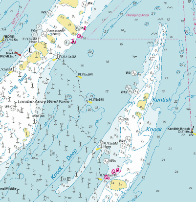
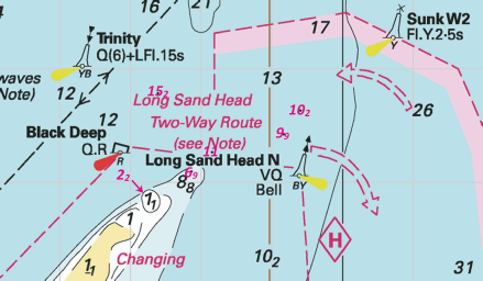
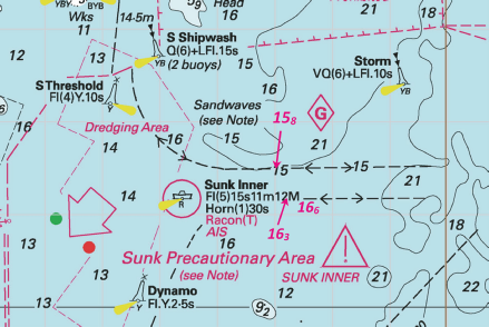
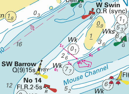
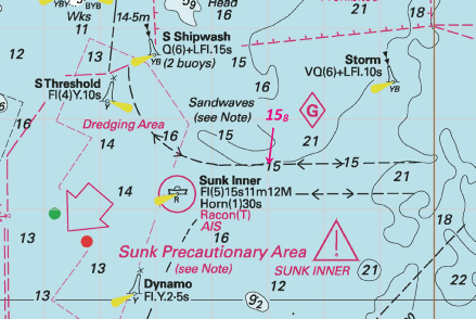
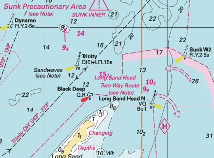
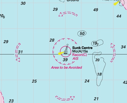
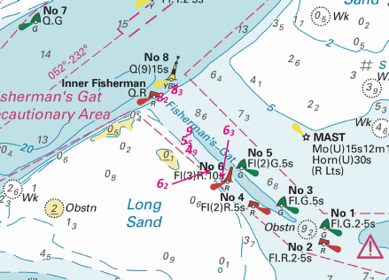
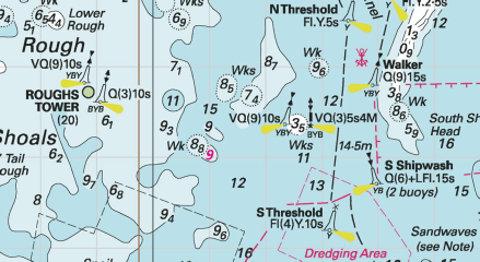
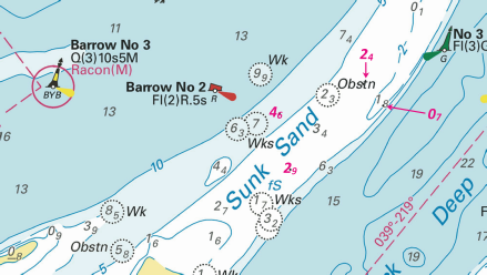
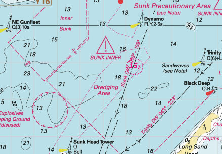
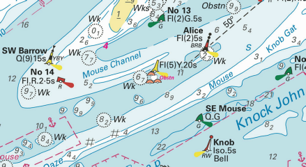
 at 51° 31´·92N., 1° 02´·86E.
 (3 buoys)
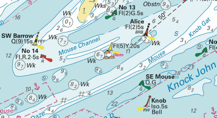
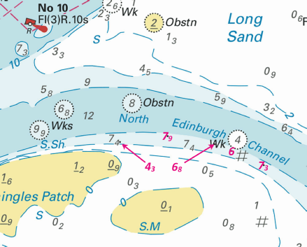
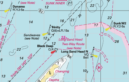

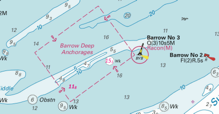
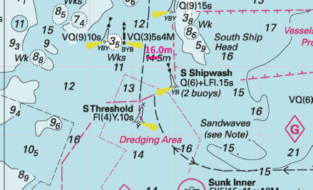
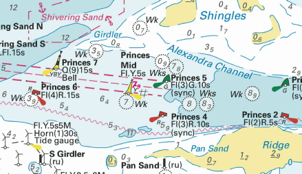
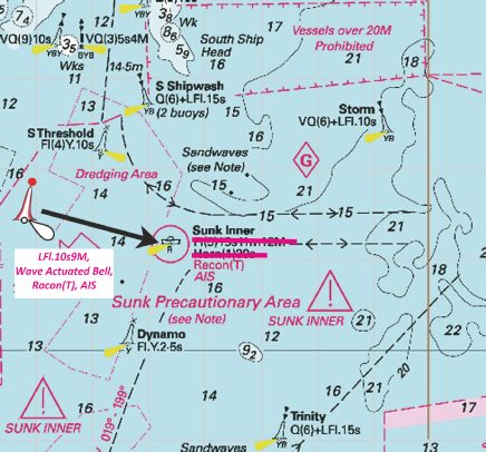
 , close SE of 51° 42´·32N., 1° 30´·32E.
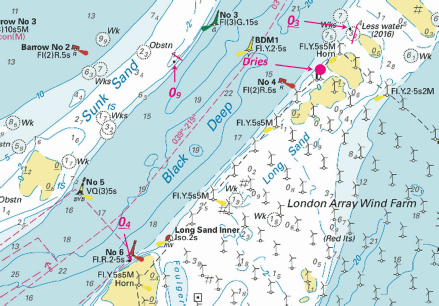
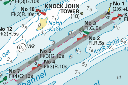
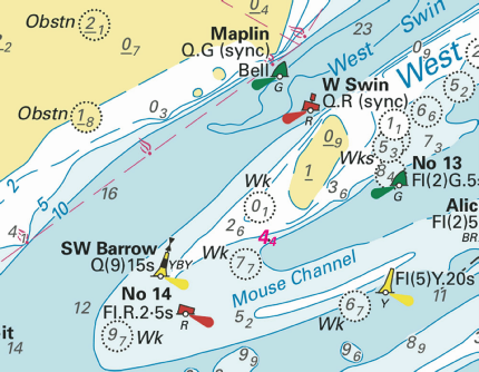

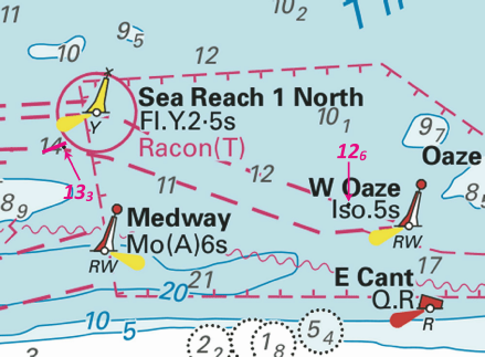
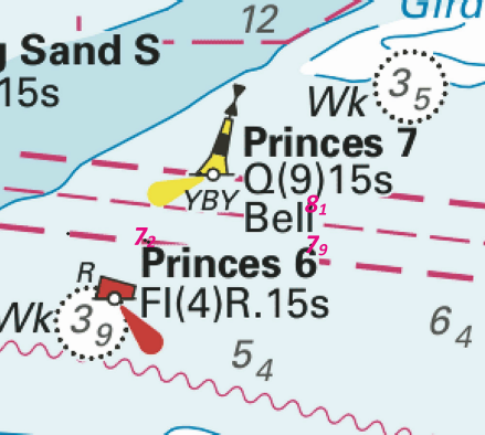
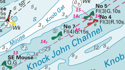
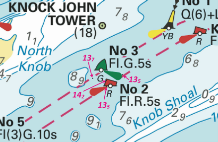
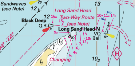
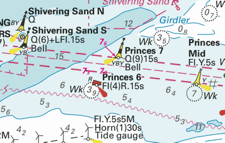
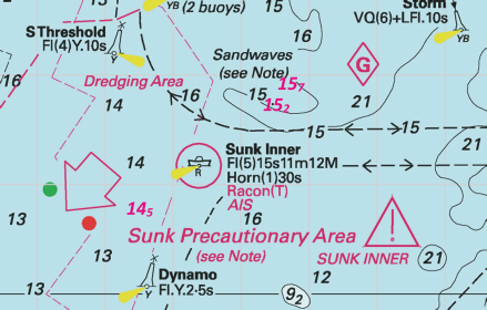
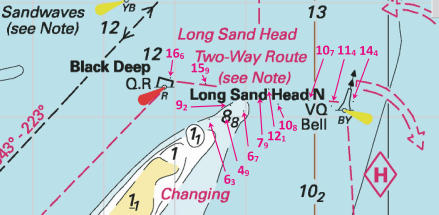
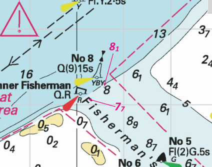

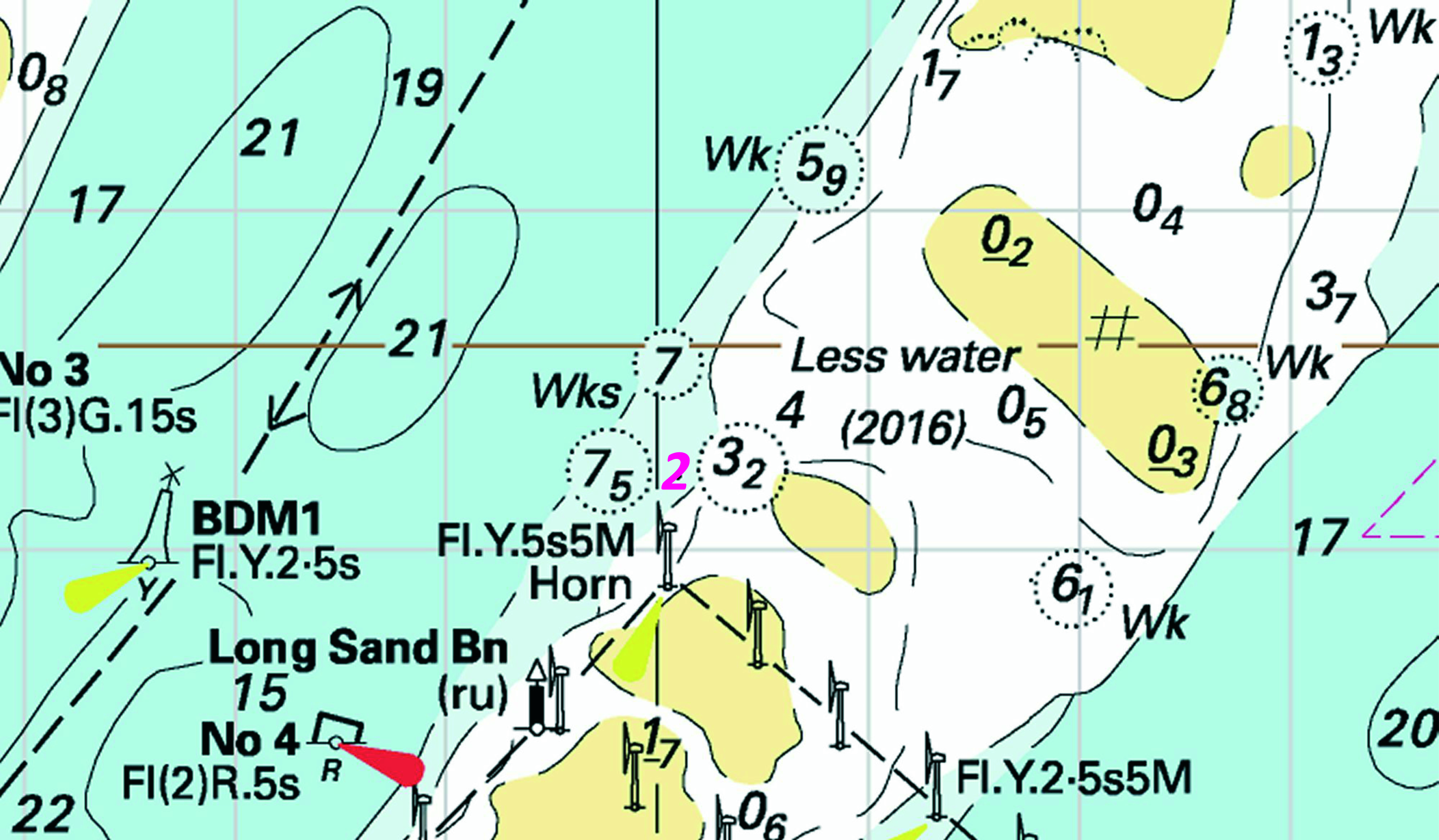
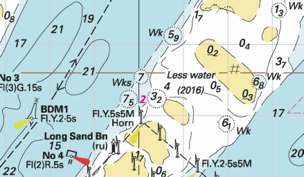

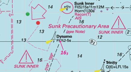
 at 51° 43´·70N., 1° 31´·18E.
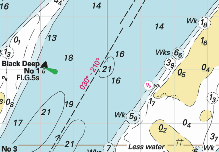
 at 51° 32´·23N., 1° 01´·59E.
 at 51° 32´·33N., 1° 01´·56E.
 at 51° 32´·38N., 1° 02´·78E.
 at 51° 34´·24N., 1° 09´·21E.
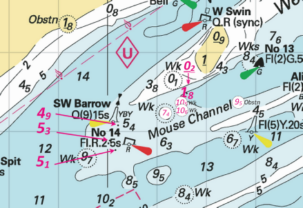
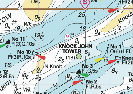
 at 51° 53´·60N., 2° 01´·96E.
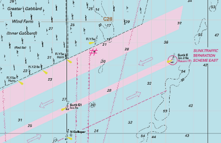
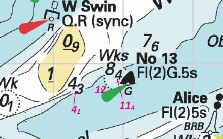
 Q(9)15s SW Barrow
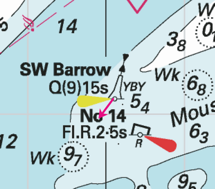
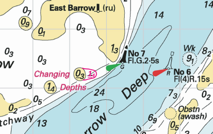
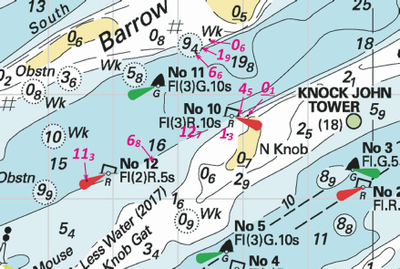
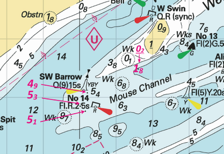
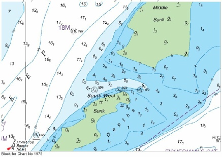
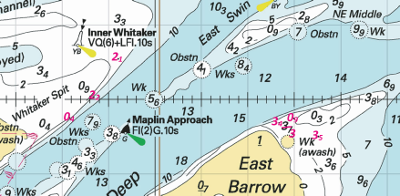
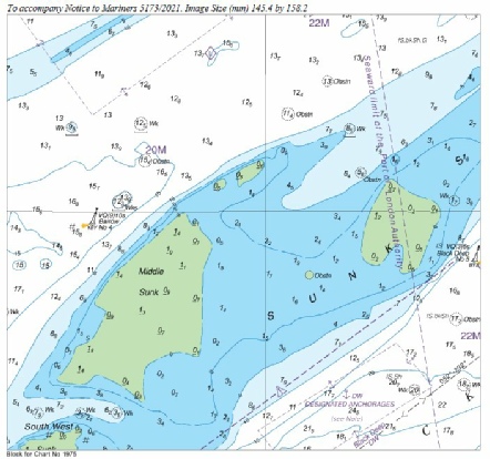
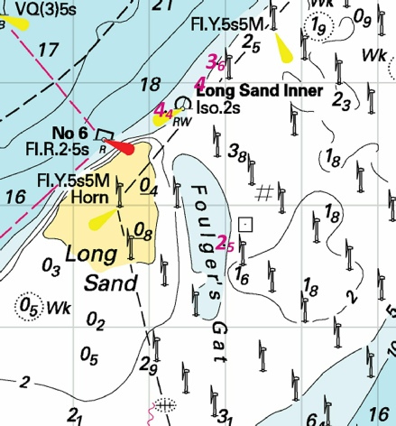
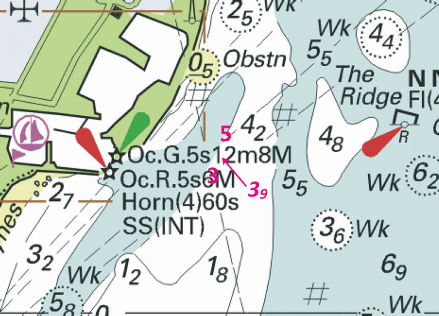
 ,
, ,
,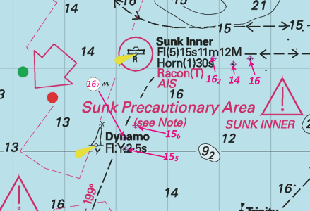
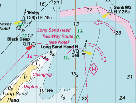


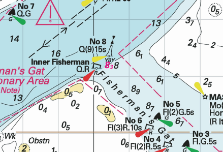
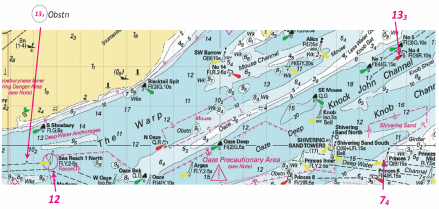
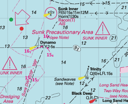
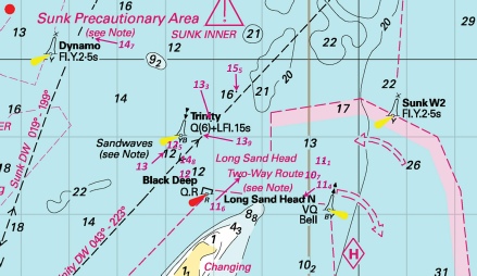
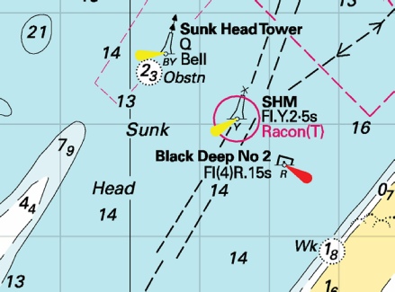
 with
with  at
at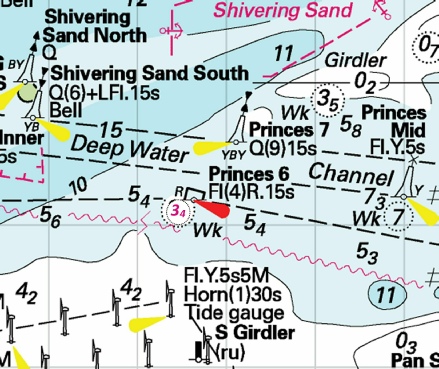
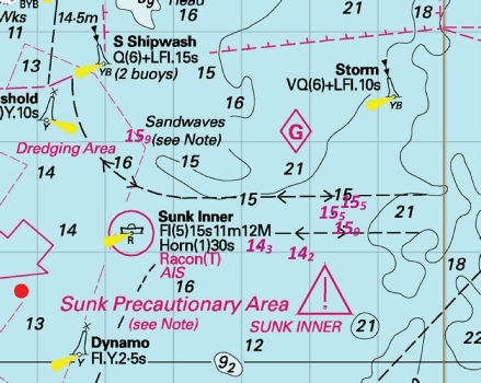
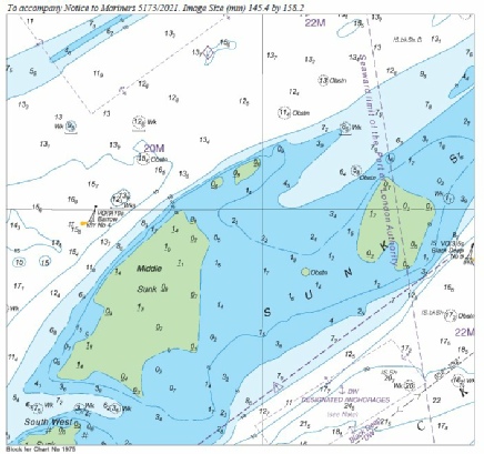
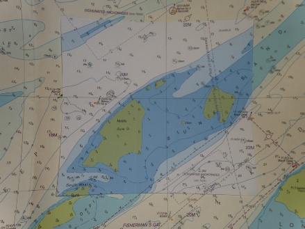
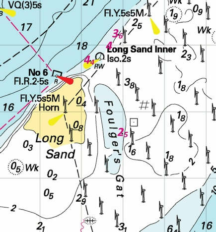

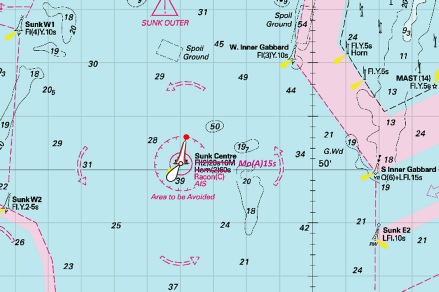
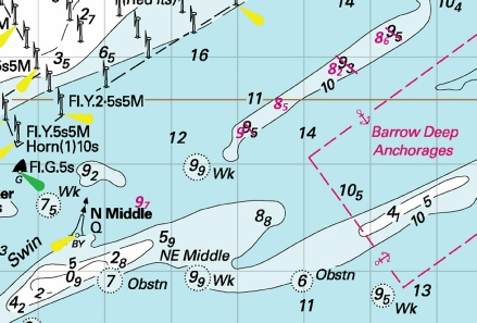
 at 51° 38´·18N., 1° 17´·84E.

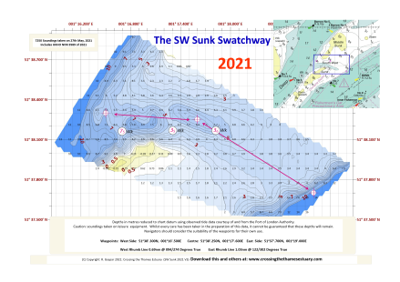

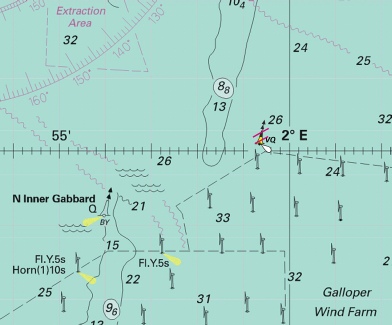
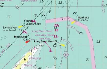
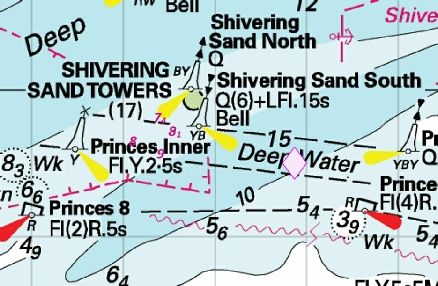
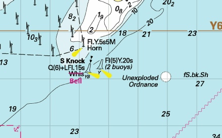
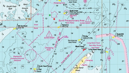
 Fl(5)Y.20s2M (3 buoys)
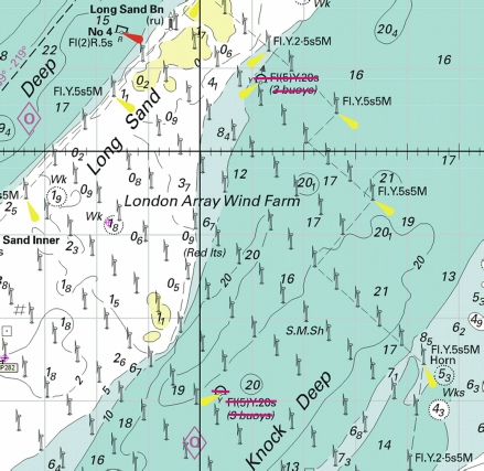
 at 51° 28´·80N., 1° 35´·00E.
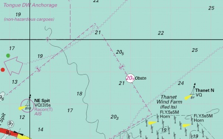
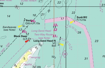
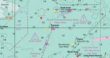
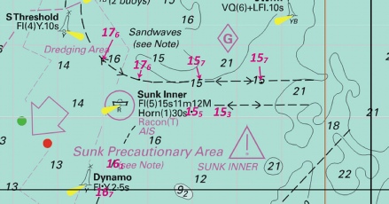

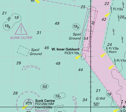
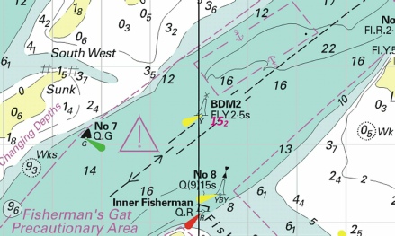
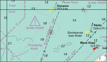
 at 51° 38´·40N., 1° 22´·19E.
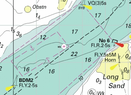
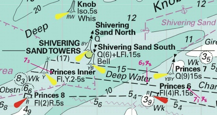
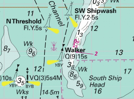
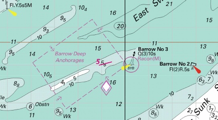
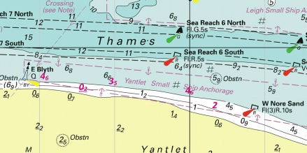


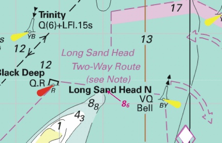
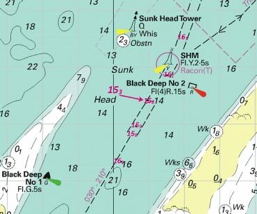

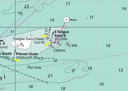
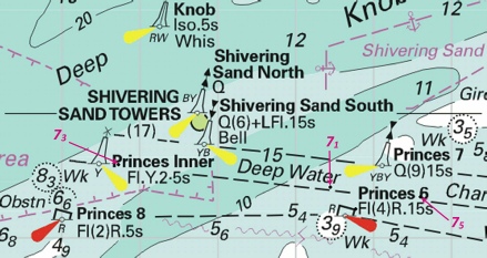
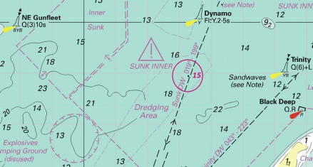
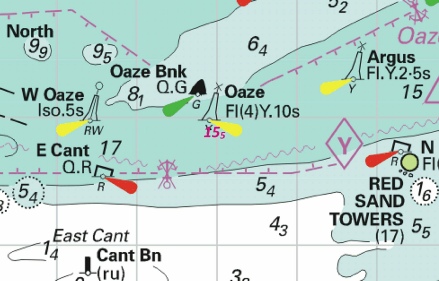
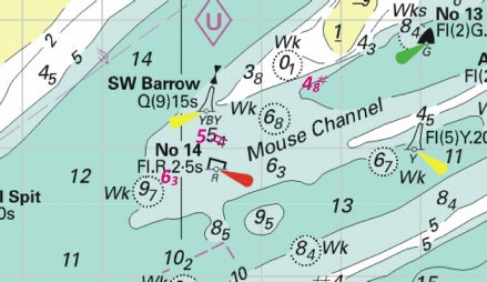
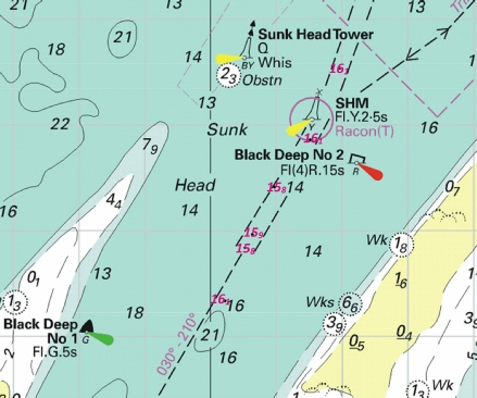
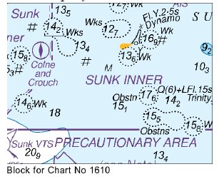
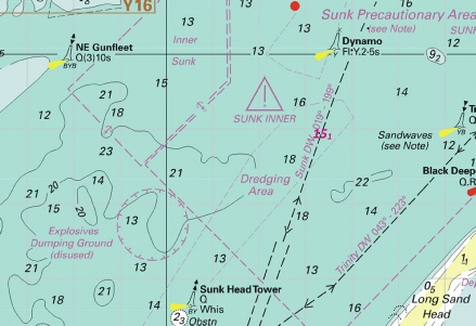
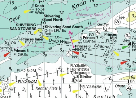
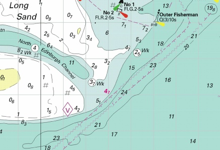

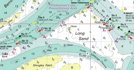
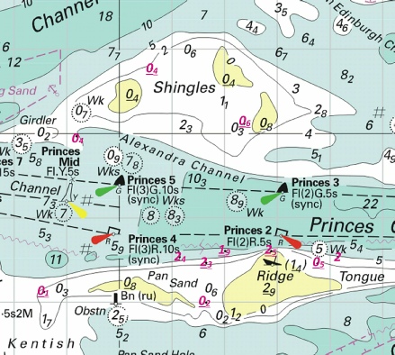
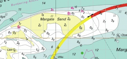

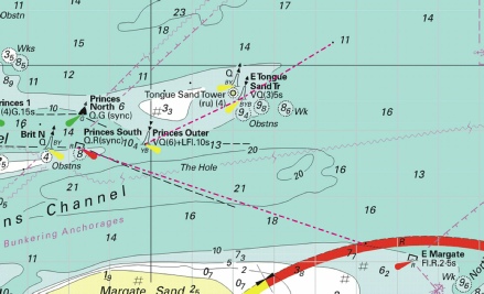
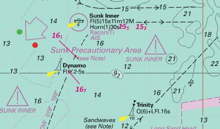
 Fl(3)G.15s No 3
 Fl.R.2·5s No 6