|
Notices - |
||
|
Week 15 |
ENGLAND - Insert: depth, 3.1, and extend 5m contour SE to enclose 52° 31´·21N., 1° 48´·69E. Delete depth, 4.5, close N. depth, 3.3, and extend 5m contour SE to enclose 52° 30´·28N., 1° 48´·34E. Delete depth, 3.1, close NW. depth, 9.6, and extend 10m contour S to enclose 52° 29´·78N., 1° 49´·70E. depth, 2.2, and extend 5m contour N to enclose 52° 34´·07N., 1° 49´·18E. Delete depth, 4.6, close E. Notice 1641 refers Base image courtesy of Imray ID10 Chart C28 and Meridian Chartware.
|
Affects: UKHO SNC: 1534, 1535 and 1543. UKHO SCC: 5614.3 and 5614.4 (Panel A, Approaches to Great Yarmouth) Imray Full Charts: C28 Four reductions of depth, three on the east side of the Holm Sand just north of Lowestoft and one on the east side of the Mid Corton Sand off Great Yarmouth.
|
|
Week 14 |
ENGLAND - Insert:
Automatic Identification System, AIS, at light, and legend, Bird Nesting Structure, close SE. at 52° 14´·28N., 1° 39´·02E.
Automatic Identification System, AIS, at light at 52° 27´·63N., 1° 45´·80E. Delete:
Automatic Identification System, AIS, at light, and legend, Bird Nesting Structure, close NE at 52° 27´·72N., 1° 45´·82E. Delete:
Notice 1502 refers Base image courtesy of Imray ID10 Chart C1 and Meridian Chartware.
|
Affects: UKHO SNC: 1504, 1535, 1543 and 1610. UKHO SCC: 5614.1 (Panel A, Orford Ness to Benacre Ness) and 5614.2 Imray Full Charts: C28 This notice confirms the Preliminary Notice 2318(T) of last year. This marks the three Bird Nesting Structures, two off Lowestoft, the third, off Minsmere. The Notices adds AIS on all three Structures and a legend on charts. Light characteristics remain as reported last year.
|
|
Week 13 |
ENGLAND - Move:
to: 52° 41´·56N., 1° 46´·53E. Notice 1367 refers Base image courtesy of Imray ID10 Chart C28 and Meridian Chartware.
|
Affects: UKHO SNC: 1534 and 1543. UKHO SCC: 5614.2, 5614.5 (Panel A, Northern Approaches to Great Yarmouth) and 5614.6 (Panel A, Caister- Imray Full Charts: C28 The North Scroby north cardinal buoy has been moved a small distance to the north. The North Scroby sands break heavily.
|
|
Week 13 |
ENGLAND - Insert: depth, 8.6, and extend 10m contour E to enclose 52° 37´·66N., 1° 45´·14E. Delete depth, 13, close SE. Notice 1434 refers Base image courtesy of Imray ID10 Chart C28 and Meridian Chartware.
|
Affects: UKHO SNC: 1534. UKHO SCC: 5614.5 (Panel A, Northern Approaches to Great Yarmouth) Imray Full Charts: C28 One single significant reduction of depth off shore north of Great Yarmouth. The reduction is just north of an outfall pipe. The end of the outfall is marked by a lit port hand buoy which also marks the lateral edge of the Caister Road.
|
|
Week 12 |
ENGLAND - Insert: legend, Works in progress (2023), orientated 222°/42°, centred on: 52° 28´·407N., 1° 45´·454E. Notice 1224 refers Base image courtesy of Imray ID10 Chart C28H and Meridian Chartware.
|
Affects: UKHO SNC: 1535 (Panel A, Lowestoft Harbour). UKHO SCC: 5614.20 (Panel A, Lowestoft Harbour) Imray Full Charts: C28H ‘Works in progress (2023) to be annotated on the east side of Waveney Dock in Lowestoft Harbour.
|
|
Week 12 |
ENGLAND - Chart 1534, Chart 5614.4 (Panel A, Approaches to Great Yarmouth) and Chart 5614.5 (Panel A, Northern Approaches to Great Yarmouth) Insert: bridge, double firm line, width 27m, joining: 52° 35´·58N., 1° 43´·52E. 52° 35´·58N., 1° 43´·61E. Chart 1534 (Panel B, Great Yarmouth Haven) [ previous Insert: the accompanying block , centred on: 52° 35´·6N., 1° 43´·6E. Chart 5614.5 (Panel B, Great Yarmouth Haven) Insert: the accompanying block , centred on: 52° 35´·6N., 1° 43´·6E. Notice 1251 refers UKHP Blocks are copyright.
|
Affects: UKHO SNC: 1534, 1534 (Panel B, Great Yarmouth Haven). UKHO SCC: 5614.5 (Panel B, Great Yarmouth Haven). Imray Full Charts: C28 Two new UKHO blocks marking the new bridge now opened in Great Yarmouth Haven: one block is for a SN Chart, the other for a SC chart. Other SNC and SCCs are to be drawn in on charts.
|
|
Week 12 |
ENGLAND - Insert:
Notice 1295 refers Base image courtesy of Imray ID10 Chart C28 and Meridian Chartware.
|
Affects: UKHO SNC: 1503 and 1504. UKHO SCC: 5606.2 and 5607.2 Imray Full Charts: C28 New lit port hand buoy close inshore close to the Gas Terminals at Bacton, Norfolk.
|
|
Week 12 |
ENGLAND - Insert: depth, 4.2, and extend 5m contour NW to enclose 52° 28´·309N., 1° 45´·654E. Delete depth, 4.9, close SW. depth, 3.6, and extend 5m contour NW to enclose 52° 28´·273N., 1° 45´·593E. Delete depth, 4.9 , close NE. depth, 1.5, enclosed by 2m contour at 52° 28´·259N., 1° 45´·633E. Delete depth, 4.1, close SW, depth, 2.4, close SE and depth, 4.3, close W. Notice 1300 refers Base image courtesy of Imray ID10 Chart C28D and Meridian Chartware.
|
Affects: UKHO SNC: 1535 (Panel, Lowestoft Harbour) and 1535. UKHO SCC: 5614.20 (Panel A, Lowestoft Harbour) and 5614.3 Imray Full Charts: C28D and C28H. Three new reduced depths just outside the entrance of Lowestoft Harbour: two still have ample water but the third is at 1.5m, a significant reduced from 4+m on the Lowestoft Bank hindering access to or from the Stanford Channel. Worth noting. A depth of 4.9m is added from an earlier NtM this year
|
|
Week 11 |
ENGLAND - Insert: symbol, overfalls at 52° 26´·29N., 1° 46´·84E. Notice 1190 refers Base image courtesy of Imray ID10 Chart C28 and Meridian Chartware.
|
Affects: UKHO SNC: 1535 and 1543. UKHO SCC: 5614.1 (Panel A, Orford Ness to Benacre) and 5614.2 Imray Full Charts: C28 A new ‘Overfalls’, a new symbols is placed just west of the Newcome Sand port hand buoy: i.e. the overfalls are just outside of the channel at the south entrance of the Stanford Channel to Lowestoft.
|
|
Week 10 |
ENGLAND - Insert: depth, 4.9 , and extend 5m contour NW to enclose 52° 28´·294N., 1° 45´·607E. Notice 1027 refers Base image courtesy of Imray ID10 Chart C28D and Meridian Chartware.
|
Affects: UKHO SNC: 1535 and 1535 (Panel, Lowestoft Harbour). UKHO SCC: 5614.20 (Panel A, Lowestoft Harbour) and 5614.3 Imray Full Charts: C28D One reduction of depth in the approaches to Lowestoft Harbour entrance. Unlikely to hinder leisure craft.
|
|
Week 10 |
ENGLAND - Replace:
Insert: depth, 1.7 , and extend 2m approximate contour E to enclose 52° 30´·93N., 1° 48´·54E. Delete depth, 7.1 , close NE. Notice 1082 Base image courtesy of Imray ID10 Chart C28 and Meridian Chartware.
|
Affects: UKHO SNC: 1535 and 1543. UKHO SCC: 5614.2. Imray Full Charts: C28 A wreck on the eastern side of the Holm Sand (off Lowestoft) is deleted and a reduced depth of 1.7m placed in lieu.
|
|
Week 09 |
ENGLAND - Note: This update is included in New Edition 106, published 22 February 2024. Insert depth, 7.7, and extend 10m contour NE to enclose 52° 44´·09N., 1° 57´·77E. Delete depth, 8.7, close S and depth, 8.8, close SW. depth, 9.8, enclosed by 10m contour at 52° 41´·42N., 1° 59´·03E. Delete depth, 10.8, close S. depth, 9.7, enclosed by 10m contour at 52° 46´·59N., 1° 52´·25E. Delete depth, 10.1, close S. Notice 911 refers Base image courtesy of Imray ID10 Chart C28 and Meridian Chartware.
|
Affects: UKHO SNC: 1408, 1504 and 1543. UKHO SCC: 5614.2 Imray Full Charts: C28 Three reductions of depth variously on the Newarp Banks well off Scroby and Hemsby. Unlikely to hinder leisure craft.
|
|
Week 08 |
New Editions of ADMIRALTY Charts to be published 22 February 2024 Chart 106 - Note: This chart is to be deleted from the list of charts affected by Notice 2900(T)/19. This chart remains affected by Notice 482(T)/24. Chart 108 England - 1:75,000 Wells- |
Includes significant safety- |
|
Week 03 |
ENGLAND - Insert: depth, 13.6, and extend 15m contour E to enclose 52° 38´·05N., 1° 52´·40E. depth, 11.7, enclosed by 15m contour 52° 37´·93N., 1° 52´·42E. Delete depth, 17.9, close N. depth, 9.4, and extend 10m contour N to enclose 52° 37´·89N., 1° 51´·84E. Delete depth, 9.7, close SW. depth, 14.2, enclosed by 15m contour 52° 37´·67N., 1° 52´·62E. Delete depth, 18.5, close S. depth, 16.5, and extend 20m contour E to enclose 52° 37´·61N., 1° 52´·85E. depth, 11.9, and extend 15m contour E to enclose 52° 37´·44N., 1° 52´·55E. Delete depth, 19.9, close NE. depth, 16.7, and extend 20m contour E to enclose 52° 37´·30N., 1° 52´·66E. Insert sounding out of position: depth 11.7, and extend 15m contour SE to enclose 52° 37´·93N., 1° 52´·42E. Delete depth, 13.7, close NW. depth, 13.6, and extend 15m contour E to enclose 52° 37´·52N., 1° 52´·57E. Notice 259 refers Base image courtesy of Imray ID10 Chart C28 and Meridian Chartware.
|
Affects: UKHO SNC: 1504, 1534 and 1543 UKHO SCC: 5614.2 Imray Full Charts: C28 9 reductions of depth in the entrance to the Barley Picle twixt the Middle Cross and South Cross Sands (offshore of Great Yarmouth). Some quite significant changes in depth but all still unlikely to hinder leisure craft.
|
|
SCROLL DOWN FOR PRE- |
||
|
Week 52 |
ENGLAND - Works are taking place at Berth 1, 52° 34´·516N., 1° 44´·031E. Construction of additional pontoon facilities are taking place in the vicinity of position 52° 34´·413N., 1° 44´·033E. Mariners are advised to navigate with caution in the area. Charts will be updated when works are complete. Notice 4979(P) refers Base image courtesy of Imray ID10 Chart C28C and Meridian Chartware.
|
Affects: UKHO SNC: 1534 UKHO SCC: 5614.4 and 5614.5 Imray Full Charts: C28C Works on Berth 1 in the River Yare and associated new pontoon works close by. The tide runs hard at that point.
|
|
Week 51 |
ENGLAND - Insert: drying height, 0.1, enclosed by 0m low water line at 52° 28´·18N., 1° 45´·53E. Delete depth, 1.6, close N. Notice 4888 refers Base image courtesy of Imray ID10 Chart C28D and Meridian Chartware.
|
Affects: UKHO SNC: 1535 UKHO SCC: 5614.3 Imray Full Charts: C28D One reduction of depth on the west side of the Newcome Sand approaching Lowestoft. Worth noting if using the Lowestoft South Road.
|
|
Week 50 |
ENGLAND - Replace:
Notice 4681 refers Base image courtesy of Imray ID10 Chart C28 and Meridian Chartware.
|
Affects: UKHO SNC: 1535 UKHO SCC: 5614.3 Imray Full Charts: C28 This notice is only updating the Small Craft Chart covering the Holm Sand (north of Lowestoft probably because the last edition of the relevant SNC (SNC 1535) included the change. The change is replace the wreck icon and depth 4.7m with just the depth of 1.7m. From which we can conclude that the wreck has been covered by sand. There were a number of revised depths around the Holm Sand vide NtM 956 so I have used the same image but updated it.
|
|
Week 50 |
ENGLAND - A dangerous wreck exists in approximate position 52° 35´·000N., 1° 43´·800E. Mariners are advised to navigate with caution in the area and consult the local port authorities for the latest information. Notice 4713(T) refers Base image courtesy of Imray ID10 Chart C28C and Meridian Chartware.
|
Affects: UKHO SNC: 1534 UKHO SCC: 5614.4 and 5614.5 Imray Full Charts: C28C A dangerous wreck is reported in the River Yare close to the west side of the bank, just above the tunnel.
|
|
Week 48 |
East Coast Of England - Caister Road - Moved to new assigned position: Latitude 52° 40.760’N., Longitude 001° 45.800’E. North Scroby Lighted Buoy Moved to new assigned position: Latitude 52° 41.560’N., Longitude 001° 46.530’E. Movement effected consequent upon a recent survey. Trinity House Notices to Mariners No 30 of 2023 refers Base image courtesy of Imray ID10 Chart C28 and Meridian Chartware.
|
Affects: UKHO SNC: 1534 and 1543. UKHO SCC: 5614. 5 (Panel A, Northern Approaches to Great Yarmouth). Imray Full Charts: C28 Trinity House have moved the North Caister North Cardinal Buoy to the north. There have been several UKHO Notices this year advising changed depth in and around the North Scroby sands.
|
|
Week 45 |
ENGLAND - Insert: depth, 2.9, enclosed by 5m approximate contour 52° 36´·55N., 1° 46´·52E. Notice 4095 refers Base image courtesy of Imray ID10 Chart C28 and Meridian Chartware.
|
Affects: UKHO SNC: 1534 UKHO SCC: 5614.5 (Panel A, Northern Approaches to Great Yarmouth) Imray Full Charts: C28 This notice is identical to NtM 3902 last week. Its purpose is to notify the correction to the appropriate Small Craft Chart (5614.5 Panel A).
|
|
Week 44 |
ENGLAND - Insert: depth, 2.9, enclosed by 5m approximate contour 52° 36´·55N., 1° 46´·52E. Notice 3902 refers Base image courtesy of Imray ID10 Chart C28 and Meridian Chartware.
|
Affects: UKHO SNC: 1534 UKHO SCC: 5614.5 (Panel A, Northern Approaches to Great Yarmouth) Imray Full Charts: C28 One reduction of depth just east of the Scroby Elbow SHB. In week 37 (NtM 3088) we had a series of reductions of depth along the west edge of the South Scroby sands so this reduction is added (in blue) to the previous image.
|
|
Week 43 |
ENGLAND - Insert: depth, 9.6, enclosed by 10m contour at 52° 38´·87N., 1° 49´·13E. depth, 1.8, enclosed by 2m contour at 52° 37´·99N., 1° 49´·13E. Delete depth, 12.7, close N. depth, 0.7, enclosed by 2m contour at 52° 38´·06N., 1° 48´·80E. Delete depth, 10.8, close N. Notice 3842 refers Base image courtesy of Imray ID10 Charts C28 and Meridian Chartware.
|
Affects: UKHO SNC: 1534 and 1543 UKHO SCC: 5614.2 and 5614.6 (Panel A, Caister- Imray Full Charts: C28 Three dramatic reductions of depth e.g. from 10.8m to 0.7m, on the east side of the Middle Scroby Sands. The east side of the Scoby Sands i.e abutting Barley Picle is not marked by buoyage.
|
|
Week 41 |
ENGLAND - Insert: depth, 7.4 at 52° 08´·48N., 1° 38´·19E. Delete depth, 8.4 and 8.6, close NE. depth, 0.9, and extend 2m approximate contour SE to enclose 52° 06´·84N., 1° 36´·83E. Notice 3585 refers Base image courtesy of Imray ID10 Charts C28 and Meridian Chartware.
|
Affects: UKHO SNC: 1504, 1543, 1610 UKHO SCC: 5614.1 (Panel A, Orford Ness to Benacre Ness) Imray Full Charts: C28 Two reductions of depth on the Aldeburgh Ridge marking reductions slightly to the east and north east parts of the sands.
|
|
Week 41 |
ENGLAND - Insert: depth, 4.3, and extend 5m contour NW to enclose 52° 28´·257N., 1° 45´·552E. Delete depth, 6.1, close SW and depth, 5.9, close NE. depth, 1.6, and extend 2m contour N to enclose 52° 28´·21N., 1° 45´·53E. Delete depth, 1.2, close S. Notice 3589 refers Base image courtesy of Imray ID10 Chart C28D and Meridian Chartware.
|
Affects: UKHO SNC: 1535 (Panel Lowestoft Harbour) and 1535 UKHO SCC: 5614.2 and 5614.3 Imray Full Charts: C28D One reduction of depth and unusually one increase of depth (to 1.6m) at the entrance of Lowestoft Harbour.
|
|
Week 39 |
New Editions of ADMIRALTY Small Craft Charts to be published on 12th October, 2023 SCC 5614.3 Approaches to Lowestoft. 1:25,000 SCC 5614.4 A Approaches to Great Yarmouth. 1:25,000 B Great Yarmouth Outer Harbour. 1:7,500 SCC 5614.5 A Northern Approaches to Great Yarmouth. 1:25,000 B Great Yarmouth Haven. 1:7,500 SCC 5614.20 Whitton Ness to Goole and Keadby and Lowestoft Harbour. A Lowestoft Harbour. 1:6,250 B Whitton Ness to Goole and Mere Dyke. 1:50,000 C Continuation to Keadby. 1:50,000 |
Includes full updates for New Edition and Notices to Mariners affecting source charts. |
|
Week 38 |
ENGLAND - Insert: depth, 9.7, and extend 10m contour W to enclose 52° 27´·76N., 1° 46´·89E. Delete depth, 10.2, close S. depth, 4.8, and extend 5m contour W to enclose 52° 26´·68N., 1° 47´·19E. depth, 4.3, and extend 5m contour N to enclose 52° 26´·48N., 1° 47´·14E. Delete depth, 5.1, close NW and depth, 5.3, close SW. depth, 2.5 at 52° 26´·37N., 1° 46´·96E. Delete depth, 3.4, close E. depth, 2.6 at 52° 26´·26N., 1° 46´·88E. Delete depth, 3.6, close SW. Replace: depth, 4.7, with depth, 4.3 at 52° 26´·57N., 1° 47´·18E. Notice 3232 refers Base image courtesy of Imray ID10 Charts C28 and Meridian Chartware.
|
Affects: UKHO SNC: 1535 and 1543 UKHO SCC: 5614.3, 5614.1 (Panel A, Orford Ness to Benacre Ness) and 5614.2 Imray Full Charts: C28 Five reductions of depth, one just south of the SW Holm SHB and 4 between the South Holm cardinal buoy and Newcombe Sand PHB. Unlikely to hinder leisure craft but the trend of the south entrance of the Stanford Channel is to shallow.
|
|
Week 37 |
ENGLAND - Insert: depth, 10.1 at 52° 34´·628N., 1° 44´·778E. Delete depth, 10.7, close N. depth, 5.4 at 52° 34´·349N., 1° 44´·299E. Delete depth, 5.8, close W. depth, 9.3, enclosed by 10m approximate contour at 52° 37´·21N., 1° 46´·47E. Delete depth, 13.4, close N and depth, 13.7, close W. depth, 2.8, enclosed by 5m approximate contour at 52° 37´·03N., 1° 46´·51E. Delete depth, 11.4, close NE. depth, 4.3, enclosed by 5m approximate contour at 52° 36´·84N., 1° 46´·51E. Delete depth, 11, close NE and depth, 11.7, close NE depth, 6, enclosed by 10m approximate contour at 52° 36´·66N., 1° 46´·50E. Delete depth, 11.3, close E. depth, 3.1, enclosed by 5m approximate contour at 52° 36´·48N., 1° 46´·59E. Delete depth, 11.1, close SW. depth, 1.3 at 52° 34´·280N., 1° 44´·243E. Delete depth, 1.8, close SW. depth, 6.3, and extend 10m contour W to enclose 52° 36´·01N., 1° 46´·65E. Notice 3088 refers Base image courtesy of Imray ID10 Charts C28 and Meridian Chartware.
|
Affects: UKHO SNC: 1534 (Panel A, Great Yarmouth Outer Harbour), 1534 and 1543 UKHO SCC: 5614.4 (Panel B, Great Yarmouth Outer Harbour), 5614.4 (Panel A, Approaches to Great Yarmouth). 5614.5 (Panel A, Northern Approaches to Great Yarmouth) and 5614.2 Imray Full Charts: C28 and C28C Three new depths around the entrance to both the Outer Harbour of Great Yarmouth and the Yare entrance plus 6 seriously reduced depths on the west side of the South Scoby Sands. There are two earlier NtMs around the Outer Harbour; these depths are included in the first image in blue.
|
|
Week 29 |
New Editions of ADMIRALTY Charts published 20 July 2023 Chart 1534 - A Great Yarmouth Outer Harbour. 1:7,500 B Great Yarmouth Haven. 1:7,500 Chart 1535 - Lowestoft Harbour. 1:6,250 Note: This chart is to be deleted from the list of charts affected by Notice 2318(P)/23. |
Includes changes to depths from the latest British Government, Trinity House and Great Yarmouth Port Authority surveys. Includes changes to depths from the latest British Government, Trinity House and ABP Lowestoft surveys. |
|
Week 28 |
ENGLAND - Works are taking place in Lowestoft and Minsmere to construct artificial nesting structures, in the following positions: Characteristic Designation Position
Mariners are advised to navigate with caution and maintain a safe distance of at least 500m from construction vessels in the area. Charts will be updated when works are complete. Notice 2318(P) refers Base image courtesy of Imray ID10 Charts C28 and C28D and Meridian Chartware.
|
Affects: UKHO SNC: 1504, 1535, 1543 and 1610. UKHO SCC: 5614.1, 5614.2 and 5614.3 Imray Full Charts: C28, C28D Three new yellow special buoys marking artificial nesting structures, one placed off shore Minsmere Haven and two off Kirkley (south of Lowestoft).
|
|
Week 27 |
New Editions of ADMIRALTY Charts to be published on 2th July, 2023 Chart 1534 - A Great Yarmouth Outer Harbour. 1:7,500 B Great Yarmouth Haven. 1:7,500 Chart 1535 - Lowestoft Harbour. 1:6,250 |
Includes changes to depths from the latest British Government, Trinity House and Great Yarmouth Port Authority surveys. Includes changes to depths from the latest British Government, Trinity House and ABP Lowestoft surveys. |
|
Week 27 |
ENGLAND - Move:
Delete: Notice 2297 refers Base image courtesy of Imray ID10 Chart C28 and Meridian Chartware.
|
Affects: UKHO SNC: 1543 and 1610. UKHO SCC: 5614.1 Imray Full Charts: C28 A slight movement of two yellow special lit buoys just off Sizewell Bank. The Image on Imray is already correct.
|
|
Week 24 |
New Editions of ADMIRALTY Small Craft Charts published 15 June 2023 SCC 5614.2 Lowestoft to Winterton Ness. 1:75,000 SCC 5614.6 A Caister- B Southwold Harbour. 1:7,500 |
Includes full updates for New Edition and Notices to Mariners affecting source charts. Note: On publication of this New Edition former Notice 1092(T)/22 is cancelled. This chart remains affected by Notice 2521(P)/22. This chart is to be deleted from the list of charts affected by Notice 4758(P)/22. Includes full updates for New Edition and Notices to Mariners affecting source charts. Note: This chart remains affected by Notice 2521(P)/22. |
|
Week 24 |
ENGLAND - Insert: depth, 13.9, and extend 15m contour E to enclose 52° 41´·56N., 1° 45´·96E. depth, 9.7, and extend 10m contour N to enclose 52° 41´·50N., 1° 46´·62E. Delete depth, 10.6, close NW. depth, 5, and extend 5m contour E to enclose 52° 41´·27N., 1° 45´·89E. depth, 6.5 at 52° 41´·39N., 1° 45´·82E. Delete depth, 7.2, close SW. Replace: depth, 12.4, with depth, 9.8, and extend 10m contour NE to enclose 52° 41´·50N., 1° 45´·87E. depth, 8.2, with depth, 6.9 at 52° 41´·52N., 1° 45´·66E. Notice 1956 refers Base image courtesy of Imray ID10 Chart C28 and Meridian Chartware.
|
Affects: UKHO SNC: 1534 and 1543. UKHO SCC: 5614. 5 (Panel A, Northern Approaches to Great Yarmouth). Imray Full Charts: C28 Six reductions of depth in the north part of Caister Road close by the Hemsby and North Scroby buoys. Unlikely to hinder leisure craft.
|
|
Week 23 |
ENGLAND - Insert: depth, 5.7 at 52° 34´·813N., 1° 44´·727E. Delete depth, 7.9, close SE. depth, 10.2 at 52° 34´·697N., 1° 44´·657E. Delete depth, 11.8, close SW. depth, 10.2 at 52° 34´·651N., 1° 44´·729E. Delete depth, 11.5, close NE. depth, 9.5, and extend 10m contour NE to enclose 52° 34´·632N., 1° 44´·777E. Delete depth, 11.6, close SE. depth, 9.9, and extend 10m contour N to enclose 52° 34´·630N., 1° 44´·618E. Delete depth, 10.6, close E. depth, 7.7 at 52° 34´·584N., 1° 44´·834E. depth, 10.8 at 52° 34´·585N., 1° 44´·872E. Delete depth, 12.4, close NE. drying height, 0.4, and extend 0m low water line NW to enclose 52° 34´·542N., 1° 44´·686E. depth, 6.9 at 52° 34´·486N., 1° 44´·718E. Delete depth, 7.3, close NE. and depth, 7.2, close SW. depth, 6 at 52° 34´·363N., 1° 44´·581E. Delete depth, 6.9, close N. depth, 1.5, enclosed by 2m contour at 52° 34´·548N., 1° 44´·377E. depth, 6.7 at 52° 34´·601N., 1° 44´·391E. depth, 9.8, and extend 10m contour E to enclose 52° 35´·48N., 1° 45´·11E. Delete depth, 10.7, close NE. depth, 9.8, and extend 10m contour SE to enclose 52° 35´·23N., 1° 45´·04E. depth, 4.9, and extend 5m contour N to enclose 52° 35´·28N., 1° 44´·54E. depth, 4.9, and extend 5m contour SE to enclose 52° 35´·01N., 1° 44´·63E. depth, 7.7 at 52° 34´·58N., 1° 44´·83E. depth, 4.9, and extend 5m contour NE to enclose 52° 34´·32N., 1° 44´·53E. Delete depth, 6.2, close NE. depth, 2.2 at 52° 34´·26N., 1° 44´·41E. depth, 9.9, enclosed by 10m contour at 52° 34´·23N., 1° 45´·10E. Delete depth, 11.6, close SE. depth, 6.6 at 52° 33´·70N., 1° 45´·27E. Replace: depth, 3.6, with depth, 2.8 at 52° 34´·751N., 1° 44´·756E. Notice 1877 refers Base image courtesy of Imray ID10 Chart C28, C28C and Meridian Chartware.
|
Affects: UKHO SNC: 1534 (Panel A, Great Yarmouth Outer Harbour), 1534 and 1535. UKHO SCC: 5614. 4 (Panel B, Great Yarmouth Outer Harbour and 5614.3 and 5614.4 (Panel A, Approaches to Great Yarmouth). Imray Full Charts: C28 and C28C Twenty-
|
|
Week 23 |
ENGLAND - Insert: depth, 6.6 at 52° 35´·18N., 1° 46´·87E. depth, 7.8 at 52° 34´·36N., 1° 47´·25E. depth, 10.9 at 52° 33´·61N., 1° 47´·85E. Delete depth, 11.4, close SE. Notice 1884 refers Base image courtesy of Imray ID10 Chart C28 and Meridian Chartware.
|
Affects: UKHO SNC: 1534, 1534 and 1535. UKHO SCC: 5614. 4 (Panel A, Approaches to Great Yarmouth), 5614.3 and 5614.5 (Panel A, Northern approaches to Great Yarmouth). Imray Full Charts: C28 Three reduction of depth in the Holm channel (southern approach to Great Yarmouth) between the SW Scroby and Mid Corton starboard hand buoys. Unlikely to hinder leisure craft.
|
|
Week 21 |
New Editions of ADMIRALTY Small Craft Charts to be published on 8th June, 2023 SCC 5614.1A Orford Ness to Benacre Ness. 1:75,000 B Orford Ness. 1:50,000 |
Includes full updates for New Edition and Notices to Mariners affecting source charts. |
|
Week 21 |
ENGLAND - Insert: depth, 7.8, and extend 10m contour N to enclose 52° 41´·01N., 1° 52´·99E. Delete depth, 25.5, close NW. depth, 9.8, and extend 10m contour NE to enclose 52° 40´·98N., 1° 53´·12E. depth, 18.6, and extend 20m contour E to enclose 52° 40´·89N., 1° 53´·30E. depth, 19.8, and extend 20m contour E to enclose 52° 40´·53N., 1° 53´·49E. Delete depth, 25.5, close N. depth, 10.4 at 52° 37´·99N., 1° 51´·40E. Delete depth, 11.8, close SE. depth, 9.7, and extend 10m contour E to enclose 52° 37´·82N., 1° 51´·77E. Delete depth, 10.7, close N. depth, 11.8, and extend 15m contour E to enclose 52° 37´·82N., 1° 52´·20E. depth, 7.2, and extend 10m contour E to enclose 52° 37´·71N., 1° 51´·65E. Delete depth, 8.9, and 12 close NW Notice 1710 refers Base image courtesy of Imray ID10 Chart C28 and Meridian Chartware.
|
Affects: UKHO SNC: 1504, 1534 and 1543 UKHO SCC: 5614.2 Imray Full Charts: C28 Four reduction of depth on the east side of the Middle Cross Sand (off Caister) and four reductions of depth in the channel twixt the Middle Cross Sand and South Cross Sand. Unlikely at those depths to hinder leisure craft but nonetheless a couple at the Middle Cross Sand are dramatic (e.g. 25.5m down to 7.8m).
|
|
Week 20 |
ENGLAND - Insert: depth, 2.1 at 52° 28´·466N., 1° 45´·414E. Delete depth, 2.7 , close SW. Notice 1656 refers Base image courtesy of Imray ID10 Chart 28H and Meridian Chartware.
|
Affects: UKHO SNC: 1535 UKHO SCC: 5614.20 (Panel A, Lowestoft Harbour) Imray Full Charts: C28H One reduction of depth in Waveney Dock of Lowestoft Harbour (not where we ought to be!).
|
|
Week 18 |
ENGLAND - Insert: depth, 14.7, and extend 15m contour S to enclose 52° 44´·13N., 1° 52´·86E. Delete depth, 17.8, close S and depth, 17.5, close E depth, 9.9, and extend 10m contour NE to enclose 52° 44´·89N., 1° 53´·47E. Delete depth, 10.3, close NW. Notice 1549 refers Base image courtesy of Imray ID10 Chart C28 and Meridian Chartware.
|
Affects: UKHO SNC: 106 and 1504 UKHO SCC: 5614.2 Imray Full Charts: C28 Two reductions of depth around the North-
|
|
Week 17 |
ENGLAND - Insert: depth, 14.7, and extend 15m contour SW to enclose 52° 44´·13N., 1° 52´·86E. Delete depth, 15.7, close SW. Notice 1487 refers Base image courtesy of Imray ID10 Chart C28 and Meridian Chartware.
|
Affects: UKHO SNC: 1543 UKHO SCC: 5614.25 Imray Full Charts: C28 One reduction of depth east of the NE Cross Sand cardinal buoy. Unlikely to hinder leisure craft.
|
|
Week 15 |
ENGLAND - Insert depth, 11.3 at 52° 32´·09N., 1° 46´·51E. Delete depth, 12.5, close N, depth, 12.6, close NE and depth, 13.7, close SW. depth, 11.8 at 52° 31´·75N., 1° 46´·57E. Delete depth, 12.9, close SW. depth, 5.4 at 52° 29´·40N., 1° 47´·16E. Delete depth, 6.8, close S. Notice 1280 refers Base image courtesy of Imray ID10 Chart C28 and Meridian Chartware.
|
Affects: UKHO SNC: 1534 and 1535 UKHO SCC: 5614.3 and 5614.4 (Panel A, Approaches to Great Yarmouth) and 5614.2 Imray Full Charts: C28 Three new reductions of depth in the Corton Road (north of the approaches to Lowestoft). The depths are unlikely to hinder leisure craft (note the image includes a fourth reduction of depth in the Corton Road from the previous NtM 1023).
|
|
Week 15 |
ENGLAND - Insert: depth, 4.9, and extend 5m contour E to enclose 52° 34´·782N., 1° 43´·915E. depth, 4.9, and extend 5m contour N to enclose 52° 34´·331N., 1° 44´·513E. Delete depth, 5.7, close N. depth, 3.1 at 52° 34´·296N., 1° 44´·400E. Delete depth, 3.8, close SE. depth, 2.2 at 52° 34´·265N., 1° 44´·410E. Replace: depth, 4.1, with depth, 3.6 at 52° 34´·264N., 1° 44´·491E. Notice 1318 refers Base image courtesy of Imray ID10 Chart C28C and Meridian Chartware
|
Affects: UKHO SNC: 1534 (Panel A, Great Yarmouth Outer Harbour) and 1534 (Panel B, Great Yarmouth Haven) UKHO SCC: 5614.4 (Panel B, Great Yarmouth Outer Harbour) and 5614.5 (Panel B, Great Yarnouth Haven) Imray Full Charts: C28C Four reductions of depths, one in the River Yare and three just south of the entrance to the River Yare.
|
|
Week 13 |
ENGLAND - Insert: depth, 15.3 at 52° 37´·15N., 1° 46´·35E. Delete depth, 16.4, close N. depth, 7.7 at 52° 33´·02N., 1° 47´·56E. Delete depth, 8.5, close N. depth, 7.4 at 52° 32´·36N., 1° 48´·40E. Delete depth, 8.3, close NW. Replace: depth, 10.2, with depth, 9.7, enclosed by 10m contour at 52° 33´·37N., 1° 46´·97E. Notice 1189 refers Base image courtesy of Imray ID10 Chart C28 and Meridian Chartware.
|
Affects: UKHO SNC: 1534 and 1535 UKHO SCC: 5614.3, 5614.4 (Panel A Approaches to Great Yarmouth) and 5614.5 (Panel A, Northern Approaches to Great Yarmouth) Imray Full Charts: C28 4 reductions of depth, one in the Yarmouth Road, just west of the South Scroby Sand, and three in and around the north of the Holm Sand. All unlikely to hinder leisure craft.
|
|
Week 12 |
ENGLAND - Insert: sounding out of position, 11.3 at 53° 02´·71N., 1° 05´·64E. Delete depth, 14.3, close SE. Notice 1086 refers Base image courtesy of Imray ID10 Chart C28 and Meridian Chartware.
|
Affects: UKHO SNC: 108 UKHO SCC: 5614.7 (Panel A, Cromer to Wells- Imray Full Charts: C28 One correction of a sounding just SW of the W. Sheringham west cardinal buoy (off Blakeney). Unlikely to hinder leisure craft.
|
|
Week 11 |
ENGLAND - Insert: depth, 9.1, and extend 10m contour W to enclose 52° 36´·13N., 1° 46´·62E. depth, 5, enclosed by 5m contour 52° 31´·96N., 1° 48´·58E. depth, 4.8, enclosed by 5m contour 52° 31´·69N., 1° 48´·89E. depth, 13.4, and extend 15 m contour E to enclose 52° 31´·41N., 1° 49´·40E. depth, 3.6, and extend 5m contour NW to enclose 52° 36´·39N., 1° 46´·81E. Delete depth, 7.6, close NE. depth, 9, and extend 10m contour E to enclose 52° 31´·75N., 1° 49´·22E. Delete depth, 13.2, close E. depth, 9.2, enclosed by 10m contour 52° 30´·31N., 1° 49´·73E. Delete depth, 10.8, close N. Notice 956 refers Base image courtesy of Imray ID10 Chart C28 and Meridian Chartware.
ENGLAND - Insert depth, 4.6, and extend 5m contour SW to enclose 52° 30´·10N., 1° 46´·74E. Delete depth, 4.6, close SE. depth, 1.4, and extend 2m contour SW to enclose 52° 29´·68N., 1° 47´·01E. Delete depth, 6.6, close S and depth, 2.2 close NE. the accompanying block, centred on: 52° 27´·6N., 1° 47´·2E. depth, 1.4, and extend 2m contour E to enclose 52° 28´·05N., 1° 47´·71E. depth, 7.6, and extend 10m contour E to enclose 52° 27´·84N., 1° 47´·85E. depth, 0.9, and extend 2m contour E to enclose 52° 27´·71N., 1° 47´·58E. Notice 1023 refers Base image courtesy of Imray ID10 Chart C28 and Meridian Chartware. The blocks are copyright of the UKHO
|
Affects: UKHO SNC: 1534 and 1535 UKHO SCC: 5614.2, 5614.3, 5614.4 (Panel A, Approaches to Great Yarmouth) and 5614.5 (Panel A, Northern Approaches to Great Yarmouth) Imray Full Charts: C28 Seven reductions of depth in and around the approaches to Great Yarmouth. Not particularly likely to hinder leisure craft This notice is co-
Affects: UKHO SNC: 1535 UKHO SCC: 5614.2 and 5614.3. Imray Full Charts: C28 Five additional reductions of depth on and around the approaches to Lowestoft and includes a new UKHO block. Obviously the UKHO block is useful.
|
|
Week 9 |
New Editions of ADMIRALTY Charts to be published on 16th March, 2023 Chart 1543 England - SCC 5605.8 Dover to Deal. 1:37,500 SCC 5605.9 Deal to Ramsgate. 1:37,500 |
Includes changes to depths from the latest British Government surveys. Includes full updates for New Edition and Notices to Mariners affecting source charts. |
|
Week 6 |
ENGLAND - Insert depth, 10.1 at 52° 41´·74N., 1° 46´·34E. Delete depth, 10.6, close SE. depth, 9.8, enclosed by 10m contour at 52° 41´·58N., 1° 46´·50E. Delete depth, 10.7, close NW. depth, 7.1 at 52° 41´·41N., 1° 46´·69E. Delete depth, 7.6, close NW Notice 514 refers Base image courtesy of Imray ID10 Chart C28 and Meridian Chartware.
|
Affects: UKHO SNC: 1534 UKHO SCC: 5614.5 Imray Full Charts: C28 Three reductions of depth on the east side of the North Scroby Sands between the Hemsby and N. Scroby buoys. Unlikely to hinder leisure craft.
|
|
SCROLL DOWN FOR PRE- |
||
|
Week 49 |
ENGLAND - Insert: depth, 3.1, and extend 5m contour W to enclose 52° 36´·20N., 1° 46´·67E. Notice 4872 refers Base image courtesy of Imray ID10 Chart C28 and Meridian Chartware.
|
Affects: UKHO Charts: 1534 and 1543 UKHO Leisure Charts: 5614.5 (Panel A, Northern Approaches to Great Yarmouth) and 5614.2 Imray Charts: C28 One new reduction of depth on the east side of the Yarmooth Road, close by two previous reductions of depth vide NtM 1124(T) earlier this year.
|
|
Week 46 |
ENGLAND - Insert: depth, 4.8, enclosed by 5m contour at 52° 26´·56N., 1° 47´·18E. Delete depth, 5.4, close NW. and depth, 5, close NE. Notice 4575 refers Base image courtesy of Imray ID10 Chart C28 and Meridian Chartware.
|
Affects: UKHO Charts: 1535 and 1543 UKHO Leisure Charts: 5614.1 and 5614.2 Imray Charts: C28 One solitary reduction of depth at the south entrance of the Stanford Channel between the South Holm and Newcome Sand buoys. At 4.8m, unlikely to hinder leisure craft.
|
|
Week 44 |
ENGLAND - Move:
Notice 4184 refers Base image courtesy of Imray ID10 Chart C28 and Meridian Chartware.
|
Affects: UKHO Charts: 1535 and 1543 UKHO Leisure Charts: 5614.2. Imray Charts: C28 This Notice is repeating NtM 4057 issued in week 42 to report the movement of the NW and W. Holm SHBs. This is to correct further SNC and SCC UKHO charts.
|
|
Week 42 |
ENGLAND - Insert depth, 1.8, enclosed by 2m contour at 52° 28´·534N., 1° 43´·428E. Delete depth, 2.4, close W. depth, 1.9, enclosed by 2m contour at 52° 28´·536N., 1° 43´·491E. Delete depth, 2.7, close W. depth, 5, and extend 5m contour S to enclose 52° 28´·474N., 1° 45´·789E. depth, 4.9, enclosed by 5m contour at 52° 28´·470N., 1° 45´·905E. Delete depth, 5.2, close E. Notice 4016 refers Base image courtesy of Imray ID10 Chart C28 and Meridian Chartware.
|
Affects: UKHO Charts: 1535 and 1535 (Panel, Lowestoft Harbour) UKHO Leisure Charts: 5614.20 (Panel A, Lowestoft Harbour). Imray Charts: C28 4 reduction of depth, 2 in Lake Lothing (off image) and two in the approaches to Lowestoft Harbour.
|
|
Week 42 |
ENGLAND - Move:
Notice 4057 refers Base image courtesy of Imray ID10 Chart C28 and Meridian Chartware.
|
Affects: UKHO Leisure Charts: 5614.3. Imray Charts: C28 This notice is amending the positions of the NW and W Holm PHBs in the SCC chart 5614.3. These moves were first notified by Trinity House vide TH NtM 32 of 2022 in week 37.
|
|
Week 41 |
ENGLAND - Move:
Notice 3948 refers Base image courtesy of Imray ID10 Chart C28 and Meridian Chartware.
|
Affects: UKHO Charts: 1534, 1535 and 1543 UKHO Leisure Charts: 5614.4 (Panel A, Approaches to Great Yarmouth), 5614.3 and 5614.2 Imray Charts: C28 This Notice confirms the Trinity House notice announced in week 37 (vide TH NtM No 24) advising the move of the West Corton, North Holm and Mid Corton buoys.
|
|
Week 41 |
ENGLAND - Insert: depth, 2.3, and extend 5m contour E to enclose 52° 07´·74N., 1° 37´·69E. Delete depth, 3.5, close W. Notice 3989 refers Base image courtesy of Imray ID10 Chart C28 and Meridian Chartware.
|
Affects: UKHO Charts: 1543 UKHO Leisure Charts: 5614.1 (Panel A, Orford Ness to Benacre Ness Imray Charts: C28 One reduction of depth on the northern tail of the Aldeburgh Ridge off Aldeburgh.
|
|
Week 37 |
EAST COAST OF ENGLAND - North West Holm Lighted Buoy Moved to Latitude 52° 30.510’N., Longitude 001° 46.400’E. West Holm Lighted Buoy Moved to Latitude 52° 29.440’N., Longitude 001° 46.890’E. Movement effected consequent upon a recent survey. No further notice will be given. Trinity House Notice to Mariners No 32 of 2022 Base image courtesy of Imray ID10 Chart C2 and Meridian Chartware.
|
Affects: UKHO Charts: 1534, 1535 and 1543 UKHO Small Craft Charts: 5614.2 and 5614.3 Imray Charts: C28 This Trinity House notice is advising the move of the North West Holm and West Holm buoys. The NW Holm move is significant.
|
|
Week 35 |
New Editions of ADMIRALTY Small Craft Charts to be published on 15th September, 2022 5614.3 Approaches to Lowestoft. 1:25,000 5614.4 A Approaches to Great Yarmouth. 1:25,000 B Great Yarmouth Outer Harbour. 1:7,500 5614.5 A Northern Approaches to Great Yarmouth. 1:25,000 B Great Yarmouth Haven. 1:7,500 5614.20 Whitton Ness to Goole and Keadby and Lowestoft Harbour. 1:6,250 A Lowestoft Harbour. 1:50,000 B Whitton Ness to Goole and Mere Dyke. 1:50,000 C River Trent continuation to Keadby. 1:50,000 |
Includes full updates for New Edition and Notices to Mariners affecting source charts. Includes full updates for New Edition and Notices to Mariners affecting source charts. Includes full updates for New Edition and Notices to Mariners affecting source charts. Includes full updates for New Edition and Notices to Mariners affecting source charts. |
|
Week 29 |
North Holm, Middle Corton & West Corton Buoys APPROACHES TO GREAT YARMOUTH and LOWESTOFT - Middle Corton Lighted Buoy AMENDMENT: Moved to Latitude 52°33.660’N, Longitude 001°47.890’E. North Holm Lighted Buoy AMENDMENT: Moved to Latitude 52°33.760’N, Longitude 001°47.540’E. West Corton Lighted Buoy AMENDMENT: Moved to Latitude 52°34.160’N, Longitude 001°47.320’E. Movement effected consequent upon a recent survey. No further notice will be given.
|
Trinity House Notice to Mariners No 24 of 2022 Affects: UKHO Charts: 1534, 1535 and 1543 UKHO Small Craft Charts: 5614.3, 5614.4 (Panel A, Approaches to Great Yarmouth), 5614.5 (Panel A, Northern Approaches to Great Yarmouth) Imray Charts: C28 On 4th July, 2022, Trinity House moved the positions of the North Hom, and Middle and West Coton Buoys, all marking the Holm Channel. In particular the 'gap' between the North Holm and Corton Buoys is reduced.
|
|
Week 28 |
New Editions of ADMIRALTY Charts to be published on 28th July, 2022 Chart 1534 - A Great Yarmouth Outer Harbour. 1:7.500 B Great Yarmouth Haven. 1:7.500 Chart 1535 - Lowestoft Harbour. 1:6,250 |
Includes changes to depths from the latest British Government, Trinity House and Great Yarmouth Port Authority surveys. Includes changes to depths from the latest British Government, Trinity House and Great Yarmouth Port Authority surveys. |
|
Week 28 |
ENGLAND - Insert: drying height, 1.1, enclosed by 0m low water line at 52° 16´·57N., 1° 38´·06E. Delete depth, 3.5, close E. drying height, 0.9, enclosed by 0m low water line, at 52° 15´·64N., 1° 37´·85E. Delete depth, 0.3, close N. drying height, 1.6, enclosed by 0m low water line at 51° 47´·97N., 1° 11´·59E. Delete depth, 0.2, close SW. drying height, 2.2, enclosed by 0m low water line at 51° 47´·54N., 1° 10´·26E. Delete depth, 0.9, close E. Notice 2944 refers Base image courtesy of Imray ID10 Charts C1 and C28 and Meridian Chartware
|
Affects: UKHO Charts: 1543 and 1975 UKHO Leisure Charts: 5607.3 and 5614.1 (Panel A, Orford Ness to Benacre Ness) Imray Charts: C1 and C28 Imray Leisure Charts: 2000.1 and 2000.10 Two new drying heights just off the coast of Dunwich and Dunwich Cliffs, and two new drying heights off the coast of Holland-
|
|
Week 26 |
ENGLAND - Insert: depth, 10, and extend 10m contour E to enclose 52° 41´·36N., 1° 45´·90E. depth, 12.9 at 52° 40´·09N., 1° 45´·57E. Delete depth, 13.8, close SW and depth, 14.1, close NE. depth, 7.9 at 52° 33´·07N., 1° 48´·11E. Delete depth, 8.5, close SE and depth, 8.9, close N depth, 7.5 at 52° 32´·70N., 1° 48´·55E. Delete depth, 8.4, close NW. depth, 9.6, and extend 10m contour E to enclose 52° 32´·58N., 1° 48´·79E. depth, 7.3 at 52° 32´·39N., 1° 48´·78E. Delete depth, 8, close SW. depth, 13.4 at 52° 32´·39N., 1° 49´·02E. depth, 7.6, and extend 10m contour E to enclose 52° 41´·45N., 1° 46´·67E. Notice 2750 refers Base image courtesy of Imray ID10 Chart C28 and Meridian Chartware.
|
Affects: UKHO Charts: 1534, 1535 and 1543 UKHO Small Craft Charts: 5614.3, 5614.4 (Panel A, Approaches to Great Yarmouth), 5614.5 (Panel A, Northern Approaches to Great Yarmouth) and Chart 5614.6 (Panel A, Caister- Imray Charts: C28 Seven reductions of depth, three at the North Scroby sands and channel north of Caister and four at the NE Holm and Holm approaches to Great Yarmouth. Both of these areas have already reported revised depths vide NtM 1266 and 1124(T) so all soundings are included in the image.
|
|
Week 25 |
ENGLAND - Insert: depth, 3.9, and extend 5m contour N to enclose 52° 28´·325N., 1° 45´·756E. Delete depth, 5.5, close W and depth, 4.3, close E of: (a) above Notice 2533 refers Base image courtesy of Imray ID10 Chart C28D and Meridian Chartware.
|
Affects: UKHO Charts: 1535 (Panel, Lowestoft Harbour) and 1535 UKHO Small Craft Charts: 5614.3 Imray Charts: C28D One depth of reduction in the approaches to Lowestoft. At 3.9m CD unlikely to hinder leisure craft. The new sounding is arrowed in the image and two other reductions in that area refer to NtM 1798/2022.
|
|
Week 24 |
NORTH SEA - A submarine cable is being laid between Callantsoog and Winterton Ness, joining the following positions: 52° 43´·3N., 1° 41´·8E. 52° 42´·7N., 2° 23´·2E. 52° 43´·6N., 2° 33´·0E. 52° 46´·2N., 3° 03´·0E. 52° 52´·8N., 3° 13´·1E. 52° 53´·3N., 3° 20´·3E. 52° 58´·6N., 3° 26´·5E. 52° 59´·9N., 4° 00´·8E. 52° 57´·9N., 4° 19´·5E. 52° 55´·2N., 4° 30´·4E. 52° 49´·9N., 4° 41´·3E. Mariners are advised to navigate with caution in the area. (WGS84 DATUM) Notice 2521(P) refers
|
Affects: UKHO Charts: 106, 126, 1408, 1504, 1534, 1543, 1546, 1631 and 2182A UKHO Small Craft Charts: 5614.2 and 5614.6 Imray Charts: C28 New submarine cable being laid between Holland (just south of Den Helder) across to Winterton Ness, just north of Hemsby. No image for this one. |
|
Week 21 |
ENGLAND - Insert: depth, 6.9 at 52° 32´·12N., 1° 48´·90E. depth, 5.4 at 52° 32´·02N., 1° 48´·81E. depth, 3.8 at 52° 31´·71N., 1° 48´·47E. Delete depth, 4.9, close S. depth, 4.4, enclosed by 5m contour 52° 31´·57N., 1° 48´·92E. depth, 9.8, and extend 10m contour E to enclose 52° 31´·56N., 1° 49´·19E. Delete depth, 12.1, close S. depth, 9.5, and extend 10m contour E to enclose 52° 31´·11N., 1° 49´·24E. Delete depth, 1.1, close NW. depth, 6.5 at 52° 30´·41N., 1° 49´·57E. depth, 9.9, enclosed by 10m contour 52° 29´·85N., 1° 49´·60E. Delete depth, 10.4, close NE. depth, 2.5, and extend 5m contour W to enclose 52° 29´·84N., 1° 47´·05E. depth, 3.3, and extend 5m contour W to enclose 52° 35´·96N., 1° 46´·74E. Delete depth, 13.3, close NW. depth, 1.5, enclosed by 2m contour at 52° 36´·28N., 1° 46´·76E. Delete depth, 4.9, close SE. depth, 2, enclosed by 2m contour at 52° 36´·13N., 1° 46´·76E. Delete depth, 12.2, close NW. Notice 1984 refers Base image courtesy of Imray ID10 Chart C28 and Meridian Chartware.
|
Affects: UKHO Small Craft Charts: 5614.3, 5614.4 (Panel A, Approaches to Great Yarmouth) and 5614.5 (Panel A, Northern Approaches to Great Yarmouth) Imray Charts: C28 Note: Former Notice 1124(T)/22 is cancelled This notice is duplicating Notice 1124(T) and 1798 to include the changes in the SCC charts on the east side of the Holm Sands (north of Lowestoft). This is to bring them up to date. The images are repeated for convenience.
|
|
Week 20 |
ENGLAND - Move:
Notice 1824 refers Base image courtesy of Imray ID10 Charts C28 and Meridian Chartware
|
Affects: UKHO Charts: 1535 and 1543. UKHO Small Craft Charts: 5614.2 and 5614.3 Imray Charts: C28 This notice reports a move south of the NW Holm starboard hand buoy in the Corton Road north of Lowestoft. This move was earlier notified of this move by Trinity House (in Week 8).
|
|
Week 20 |
ENGLAND - Insert: depth, 1.5, enclosed by 2m contour at 52° 36´·28N., 1° 46´·76E. Delete depth, 4.9, close SE. depth, 2, enclosed by 2m contour at 52° 36´·13N., 1° 46´·76E. Delete depth, 12.2, close NW. depth, 3.3, and extend 5m contour W to enclose 52° 35´·96N., 1° 46´·74E. Delete depth, 13.3, close NW. depth, 6.9 at 52° 32´·12N., 1° 48´·90E. Delete depth, 7.6, close NW. depth, 5.4 at 52° 32´·02N., 1° 48´·81E. Delete depth, 9.9, close E. depth, 3.8 at 52° 31´·71N., 1° 48´·47E. Delete depth, 4.9, close S. depth, 4.4, enclosed by 5m contour 52° 31´·57N., 1° 48´·92E. depth, 9.8, and extend 10m contour E to enclose 52° 31´·56N., 1° 49´·19E. Delete depth, 12.1 , close S. depth, 9.5, and extend 10m contour E to enclose 52° 31´·11N., 1° 49´·24E. Delete depth, 11, close NW. depth, 6.5 at 52° 30´·41N., 1° 49´·57E. depth, 9.9, enclosed by 10m contour at 52° 29´·85N., 1° 49´·60E. Delete depth, 10.4, close NE. depth, 2.5, and extend 5m contour W to enclose 52° 29´·84N., 1° 47´·05E. depth, 5, enclosed by 5m contour at 52° 28´·367N., 1° 45´·768E. Delete depth, 6.1, close NE. depth, 3 at 52° 28´·279N., 1° 45´·725E. Notice 1798 refers Base image courtesy of Imray ID10 Charts C28 and Meridian Chartware
|
Affects: UKHO Charts: 1534, 1535 (Panel, Lowestoft Harbour), 1535 and 1543. UKHO Small Craft Charts: 5614.2 Imray Charts: C28 This notice report 14 reductions of depth (some dramatic) 3 off Great Yarmouth at the west edge of the Scroby Sands, 8 on the eastern edge of the Holm Sand north of Lowestoft and one east of the Holm Sand, and 2 in the Lowestoft Approaches. Most of those are confirming the Temporary Notice 1124(T) in week12, save one depth on the western side of the Holm Sand is changed. Three images. The isolated sounding on the east side of the Holm Sand should be seen in conjunction with the image of Notice 1170 in Week 13.
|
|
Week 20 |
ENGLAND - Delete: Fl.10s Newarp and associated radar beacon, Racon (O), and Automatic Identification System, AIS at 52° 48´·38N., 1° 55´·68E. Notice 1812 refers Base image courtesy of Imray ID10 Charts C28 and Meridian Chartware
|
Affects: UKHO Charts: 106, 1408, 1504, 2182A and 4140. UKHO Small Craft Charts: 5614.2 Imray Charts: C28 The Newarp safe water buoy northeast of Winterton Ness has been deleted.
|
|
Week 18 |
ENGLAND - Note: Chart 1543 is to be deleted from the list of charts affected by Notice 3799(P)/21. Insert: submarine cable, 52° 27´·23N., 1° 44´·27E. 52° 27´·06N., 1° 46´·05E. 52° 27´·06N., 1° 47´·90E. 52° 26´·90N., 1° 49´·41E. 52° 26´·88N., 1° 52´·42E. 52° 26´·37N., 1° 59´·40E. 52° 26´·18N., 2° 00´·58E. 52° 26´·43N., 2° 01´·84E. 52° 26´·48N., 2° 07´·11E. 52° 26´·76N., 2° 08´·46E. 52° 27´·21N., 2° 09´·57E. 52° 30´·23N., 2° 11´·69E. 52° 30´·68N., 2° 14´·53E. 52° 30´·75N., 2° 18´·21E. Notice 1674 refers Base image courtesy of Imray ID10 Chart C25 and Meridian Chartware
|
UKHO Charts: 1543. UKHO Small Craft Charts: 5606.5, 5606.6, 5606.2 Imray Charts: C25 New submarine cable east out from the shore south of Lowestoft. Presumably waiting for completion to the Netherlands in the future.
|
|
Week 15 |
ENGLAND - Insert: depth, 2.3 at 52° 01´·60N., 1° 31´·35E. Delete depth, 2.8, close S. Notice 1396 refers Base image courtesy of Imray ID10 Chart C1 and Meridian Chartware
|
Affects: UKHO Charts: 2052 and 2693 UKHO Small Craft Charts: 5607.5, 5614_1 Imray Charts: C1 Imray Leisure Chart: 2000.1 One reduction of depth at the southern end of the Whiting Bank (off the Ore).
|
|
Week 14 |
ENGLAND - Insert: depth, 9.7, and extend 10m contour NE to enclose 52° 42´·12N., 1° 45´·79E. Delete depth, 17, close NW. depth, 19.2, enclosed by 20m contour at 52° 42´·12N., 1° 46´·36E. Delete depth, 21, close NW and depth, 23, close SW. depth, 10.6 at 52° 42´·04N., 1° 46´·00E. Delete depth, 11.8, close NW. depth, 10.1 at 52° 41´·78N., 1° 46´·30E. Delete depth, 11.5, close SE. depth, 9.6, enclosed by 10m contour at 52° 41´·65N., 1° 46´·43E. Delete depth, 10.6, close W. depth, 5, and extend 5m contour E to enclose 52° 41´·45N., 1° 45´·61E. depth, 8.8, and extend 10m contour NE to enclose at 52° 41´·45N., 1° 45´·79E. Delete depth, 11.7, close NE. depth, 7.1 at 52° 41´·35N., 1° 46´·69E. Delete depth, 7.8, close NW. depth, 2.9 at 52° 41´·16N., 1° 45´·81E. Delete depth, 3.4, close SW. depth, 6.1, and extend 10m contour E to enclose 52° 41´·30N., 1° 45´·85E. Delete depth, 13, close N. depth, 9.8, and extend 10m contour E to enclose 52° 40´·68N., 1° 45´·76E. Delete depth, 12.8, close N. depth, 14.1, and extend 15m contour NE to enclose 52° 40´·12N., 1° 45´·62E. Replace: depth, 8.6, with depth, 7.6 at 52° 41´·47N., 1° 46´·61E. Notice 1266 refers Base image courtesy of Imray ID10 Chart C28 and Meridian Chartware
|
Affects: UKHO Charts: 106, 1534 and 1543 UKHO Small Craft Charts: 5614.2, 5614_6 (Panel A, Caister- Imray Charts: C28 13 reductions of depths (some quite significant) at the North Scroby.
|
|
Week 14 |
ENGLAND - Insert: depth, 5, and extend 5m contour E to enclose 52° 41´·45N., 1° 45´·61E. depth, 14.1, and extend 15m contour NE to enclose 52° 40´·12N., 1° 45´·62E. depth, 8.8, and extend 10m contour NE to enclose 52° 41´·45N., 1° 45´·79E. Delete depth, 11.7, close NE. depth, 7.1 at 52° 41´·35N., 1° 46´·69E. Delete depth, 7.8, close NW. depth, 2.9 at 52° 41´·16N., 1° 45´·81E. Delete depth, 3.4, close SW. depth, 9.8, and extend 10m contour E to enclose 52° 40´·68N., 1° 45´·76E. Delete depth, 12.8, close N. Replace: depth, 8.6, with depth 7.6 at 52° 41´·47N., 1° 46´·61E. Notice 1310 refers
|
Affects: UKHO Small Craft Charts: 5614_5 (Panel A, Northern Approaches to Great Yarmouth) Imray Charts: C28 This notice copies Notice 1266 above to select 7 of the 13 reductions of depths at the North Scroby to be used on the UK Small Craft Chart. Revert to the image at 1266 above. |
|
Week 13 |
ENGLAND - Insert: depth, 8.4 at 52° 34´·749N., 1° 44´·449E. depth, 7.9 at 52° 34´·748N., 1° 44´·609E. Notice 1141 refers Base image courtesy of Imray ID10 Chart C28C and Meridian Chartware
|
Affects: UKHO Charts: 1534 (Panel A, Great Yarmouth Outer Harbour) UKHO Small Craft Charts: 5614.4 Imray Charts: C28C Two reduction of depth within the Outer Harbour of Great Yarmouth (where we are not supposed to be).
|
|
Week 13 |
ENGLAND - Insert: depth, 4 , enclosed by 5m contour 52° 30´·14N., 1° 46´·81E. depth, 4.6 , enclosed by 5m contour 52° 30´·06N., 1° 46´·89E. depth, 3.1 , enclosed by 5m contour 52° 29´·86N., 1° 46´·97E. Delete depth, 4.5, close N. depth, 3.3 , and extend 5m contour SW to enclose 52° 29´·93N., 1° 46´·95E. Delete depth, 4.5 , close NE and depth, 12.2 , close SW. depth, 7 at 52° 30´·14N., 1° 46´·97E. depth, 7.8 at 52° 29´·97N., 1° 47´·09E. Notice 1170 refers Base image courtesy of Imray ID10 Chart C28 and Meridian Chartware
|
Affects: UKHO Charts: 1535 and 1543 UKHO Small Craft Charts: 5614.2 and 5614.3 Imray Charts: C28 Six reductions of depth (some dramatic) north of the Corton Road, north of the West Holm starboard hand buoy (off Lowestoft). The image includes additional depths reduced vide NtM 302 in week 4.
|
|
Week 12 |
ENGLAND - The sectors at Kirkley light in position 52° 27´·71N., 1° 44´·54E.have been amended as follows: Oc G 222°- Fl G 225°- Fl W 226°- Oc W 227°- Fl W 229°- Fl R 230°- Oc R 231°- Mariners are advised to navigate with caution in the area. These and other changes will be included in the next New Edition of Charts 1543, 5614.2 and 5614.3. Notice 1092(T) refers Base image courtesy of Imray ID10 Chart C28 and Meridian Chartware
|
Affects: UKHO Charts: 1543. UKHO Small Craft Charts: 5614.2 and 5614.3 Imray Charts: C28 The sectors for the Kirkley light (located south of Lowestoft providing the sectors lights for the approaches to the harbour) are changed. Image showing the location but not changed. The change is quite small.
|
|
Week 12 |
ENGLAND - Depths less than charted exist southwest of South Scroby and east of Holm Sand. The most significant are as follows: Depth Position 1·5m 52° 36´·28N., 1° 46´·76E. 2m 52° 36´·13N., 1° 46´·76E. 3·3m 52° 35´·96N., 1° 46´·74E. 6·9m 52° 32´·12N., 1° 48´·90E. 5·4m 52° 32´·02N., 1° 48´·81E. 3·8m 52° 31´·71N., 1° 48´·47E. 4·4m 52° 31´·57N., 1° 48´·92E. 9·8m 52° 31´·56N., 1° 49´·19E. 7·8m 52° 31´·28N., 1° 49´·00E. 6·5m 52° 30´·41N., 1° 49´·57E. 9·9m 52° 29´·85N., 1° 49´·60E. Mariners are advised to navigate with caution in the area. These changes will be included in the next New Editions of charts 5614.3, 5614.4 and 5614.5. Charts 1534, 1535, 1543 and 5614.2 will be updated by Notice to Mariners. Notice 1124 (T) refers Base image courtesy of Imray ID10 Chart C2 and Meridian Chartware
|
Affects: UKHO Charts: 1534, 1535 and 1543 UKHO Small Craft Charts: 5614.2, 5614.3, 5614.4 and 5614.5 Imray Charts: C28 Three reductions of depth on the southwest of South Scroby and eight east of the Holm Sand. The reductions east of the Holm Sand are significant but not likely to hinder leisure craft. Two images:
|
|
Week 11 |
ENGLAND - Unexploded ordnance (UXO) have been identified off the Lowestoft coast. The UXOs are located in the following positions: 52° 26´·10N., 1° 47´·50E. 52° 25´·10N., 2° 02´·10E. 52° 29´·40N., 2° 49´·91E. Further investigations are planned to determine whether retrieval or disposal of the UXOs is required. Mariners are advised to navigate with caution in these areas. Notice 985 (T) refers Base image courtesy of Imray ID10 Chart C28 and Meridian Chartware
|
Affects: UKHO Charts: 1408, 1504, 1535, 1543 and 1631 UKHO Small Craft Charts: 5614.1, 5614.2 Imray Charts: C28 Three locations of unexploded ordnance; one just southeast of the Newcome Sand port hand buoy, one about 12nm east of the Newcombe Sand and the third north of the Nord Hinder. Only the first location illustrated.
|
|
Week 9 |
ADMIRALTY Small Craft Charts published 3rd March 2022 5614.3 Approaches to Lowestoft. 1:25,000 5614.4 A Approaches to Great Yarmouth. 1:25,000 B Great Yarmouth Outer Harbour. 1:7,500 5614.5 A Northern Approaches to Great Yarmouth. 1:25,000 B Great Yarmouth Haven. 1:7,500 5614.20 Harbours on the East Coast. A Lowestoft Harbour. 1:6,250 B Whitton Ness to Goole and Mere Dyke. 1:50,000 C River Trent continuation to Keadby. 1:50,000 |
Includes changes to depths from the latest port authority surveys. Includes changes to depths from the latest British Government and Trinity House surveys. Includes changes to depths from the latest British Government and Trinity House surveys. Includes changes to depths from the latest British Government and Trinity House survey. |
|
Week 10 |
ENGLAND - Insert: radar beacon, Racon(M), at NE Cross Sand light- legend, AIS, at the NE Cross Sand light- Notice 926 refers Base image courtesy of Imray ID10 Chart C28 and Meridian Chartware
|
Affects: UKHO Charts: 106, 1504 and 1543 UKHO Small Craft Charts: 5614.2 Imray Charts: C28 This notice is adding Racon(M) and AIS to the NE Cross Sand east cardinal buoy (off Winterton Ness)
|
|
Week 8 |
EAST COAST OF ENGLAND - AMENDMENT: Moved to Latitude 52°30.753’N., Longitude 001°46.460’E. Movement effected consequent upon a recent survey. No further notice will be given. Trinity House Notice No 12 of 2022 refers Base image courtesy of Imray ID10 Chart C28 and Meridian Chartware
|
Affects: UKHO Charts: 1872, 1873 and 1874 UKHO Small Craft Charts: 5606.1 Imray Charts: C30 Imray Leisure Folios: 2100.1 A significant move south of the NW Holm starboard hard buoy in the Corton Road (approaches south to Lowestoft). The significance of that move can be seen from NtM 302 of 2022 in week 4.
|
|
Week 7 |
New Editions of ADMIRALTY Small Craft Charts 5614_3 Orford Ness to Whitby, Approaches to Lowestoft. 1:25,000 5614_4 Orford Ness to Whitby, Approaches to Great Yarmouth. 1:25,000 A Approaches to Great Yarmouth. 1:7,500 B Great Yarmouth Outer Harbour. 5614_5 Orford Ness to Whitby, Northern Approaches to Great Yarmouth. 1:25,000 A Northern Approaches to Great Yarmouth. B Great Yarmouth Haven. 1:7,500 |
Includes changes to depths from the latest local authority and commercial surveys. Includes changes to depths from the latest British Government and Trinity House surveys. Includes changes to depths from the latest British Government and Trinity House surveys. |
|
Week 4 |
ENGLAND - 5614.1 (Panel A, Orford Ness to Benacre Ness) and Chart 5614.2 Replace: depth, 6.1, with depth, 5, and extend 5m contour S to enclose 52° 26’ ·66N. , 1° 47’ ·26E. Delete depth, 5, close N. Chart 5614.2 and Chart 5614_3 Insert: depth, 4.7, enclosed by 5m contour at 52° 30’ ·30N. , 1° 46’ ·76E. Delete depth, 9.9, and associated 10m contour close W. Chart 5614_3 Insert: depth, 7.9, and extend 10m contour SW to enclose 52° 30’ ·51N. , 1° 46’ ·71E. Delete depth, 9.8, close NE. depth, 2, enclosed by 2m contour 52° 30’ ·39N. , 1° 46’ ·81E. depth, 9.8, enclosed by 10m contour 52° 30’ ·08N. , 1° 46’ ·74E. depth, 3.5 at 52° 27’ ·03N. , 1° 47’ ·31E. Delete depth, 4.1, close E. Chart 5614.2, 5614.3 and 5614_4 (Panel A, Approaches to Great Yarmouth) Move:
Notice 302 refers Base image courtesy of Imray ID10 Chart C28 and Meridian Chartware
|
Affects: UKHO Small Craft Charts: 5614.1 (Panel A, Orford Ness to Benacre Ness), 5614.2, 5614.3 and 5614.4 (Panel A, Approaches to Great Yarmouth) Imray Charts: C28 Six reduction of depth north and south approaches to Lowestoft and the moving of the South Corton south cardinal buoy. None of these are new data, rather is a tidying up of changes on the new Small Craft Charts which had been formerly notified in weeks 43, 44 and 46 last year. For simplicity I have redrawn three images illustrating these changes (which should also be read in conjunction with Notice 88(P) earlier this year).
|
|
Week 3 |
ENGLAND - Insert:
Notice 225 refers Base image courtesy of Imray ID10 Chart C28 and Meridian Chartware
|
Affects: UKHO Charts: 1504, 1543 and 1610 UKHO Small Craft Charts: 5614.1 Imray Charts: C28 New wreck off the coast of Minsmere but at 12m unlikely to hinder leisure craft.
|
|
Week 2 |
ENGLAND - Insert: depth, 4.5, enclosed by 5m contour 52° 29´·95N., 1° 46´·97E. Delete depth 11. depth, 2.2, and extend 5m contour N to enclose 52° 29´·75N., 1° 47´·11E. Delete depth, 3.3, close SE and depth, 4, close E. depth, 2.5, and extend 5m contour N to enclose 52° 29´·46N., 1° 47´·30E. Delete depth, 4.5, close NW and depth, 4.3, close SW Notice 109 refers Base image courtesy of Imray ID10 Chart C28D and Meridian Chartware
Base image courtesy of Imray ID10 Chart C28D and Meridian Chartware |
Affects: UKHO Charts: 1543 UKHO Small Craft Charts: 5614.2 and 5614.3 Imray Charts: C28D This is associated with the Preliminary Notice No 88(P) in Week 1. This records three reduced depths in the edge of the Lowestoft North Road (outside the West Holm starboard hard buoy).
|
|
Week 1 |
ENGLAND - Depths less than charted exist in the northern approaches to Lowestoft. The most significant are as follows: Depth Position 2·5m 52° 29´·456N., 1° 47´·305E. 2·2m 52° 29´·751N., 1° 47´·109E. 2·5m 52° 29´·611N., 1° 47´·158E. 2·8m 52° 29´·374N., 1° 47´·330E. 4·5m 52° 29´·954N., 1° 46´·974E. Mariners are advised to navigate with caution in the area. These changes will be included in a New Edition of Chart 1535 to be published early 2022. Notice 88(P) refers
Base image courtesy of Imray ID10 Chart C28D and Meridian Chartware |
Affects: UKHO Charts: 1535 UKHO Small Craft Charts: 5614.2 and 5614.3 Imray Charts: C28 and C28D Preliminary Notice of five reductions of depth in the Lowestoft North Road close to the Holm Sand but all outside of the starboard hand buoy of West Holm. See next week’s permanent notice No 109.
|
|
|
Scroll down for pre- |
|
|
Week 51 |
New Editions of ADMIRALTY Charts published 6th January 2022 Chart 1534 - A Great Yarmouth Outer Harbour. 1:7,500 B Great Yarmouth Haven. 1:7,500 Chart 1535 - Lowestoft Harbour. 1:6,250 |
Includes changes to depths from the latest British Government and Trinity House surveys. Includes changes to depths from the latest British Government and Trinity House surveys. |
|
Week 48 |
ENGLAND - Insert: depth, 10, enclosed by 10m contour at 52° 33´·52N., 1° 47´·85E. Delete depth, 9.4 , close SE. depth, 8.9 at 52° 33´·14N., 1° 48´·08E. Delete depth, 9.5 , close E and depth, 9.7 , close NE depth, 8.4 at 52° 32´·63N., 1° 48´·50E. Delete depth, 9.4 , close N. depth, 8.9 , and extend 10m contour E to enclose 52° 32´·48N., 1° 48´·73E. Delete: depth, 13 at 52° 32´·33N., 1° 48´·82E. Notice 4988 refers Base image courtesy of Imray ID10 Chart C28 and Meridian Chartware
|
Affects: UKHO Charts: 1534, 1535 and 1543 Imray Charts: C28 UKHO Small Craft Charts: 5614.3, 5614.4 (Panel A, approaches to Great Yarmouth) 4 Reductions of depth in the Holm channel (south approaches to Great Yarmouth) but at all over 8m, unlikely to hinder leisure craft.
|
|
Week 48 |
EAST COAST OF ENGLAND - Latitude 52° 01.730’N., Longitude 001° 38.272’E. Amendment : Wave actuated whistle replaced by wave actuated bell. No further notice will be given.
|
Trinity House Notices to Mariners No 22 of 2021 |
|
Week 46 |
ENGLAND - Insert: depth, 3.5 at 52° 27´·03N., 1° 47´·31E. Delete depth, 4.1, close E. depth, 5, and extend 5m contour S to enclose 52° 26´·66N., 1° 47´·28E. Delete depth, 5, close N 5.5 at 52° 26´·60N., 1° 47´·24E. Delete depth, 6.4, close S. depth, 3.3, and extend 5m contour S to enclose 52° 26´·37N., 1° 46´·98E. Delete depth, 4.2, close NE. depth, 4.5, and extend 5m contour E to enclose 52° 26´·26N., 1° 47´·02E. Delete depth, 5.5, close SE. Notice 4686 refers Base image courtesy of Imray ID10 Chart C28 and Meridian Chartware
|
Affects: UKHO Charts: 1535 and 1543 Imray Charts: C28 UKHO Leisure Folios: 5614.1 5614.2. Five reductions of depth around the S. Holm and Newcombe Sands buoys (entrance to the Stanford Channel to Lowestoft).
|
|
Week 44 |
ENGLAND - Move:
Notice 4475 refers Base image courtesy of Imray ID10 Chart C28 and Meridian Chartware
|
Affects: UKHO Charts: 1534, 1535 and 1543 Imray Charts: C28 UKHO Leisure Folios: 5614.2 A bit of history here: On 6th September, Trinity House told us that the South Corton SCB had been moved north- But now the UKHO are confirming the established location at 52° 33´·37N., 1° 48´·41E. Logistics not a typo! It is worth noting that the S. Corton SCB is now almost due North of the NE Holm PHB.
|
|
Week 43 |
ENGLAND - Insert: depth, 7.9, and extend 10m contour SW to enclose (a) 52° 30´·51N., 1° 46´·71E. Delete depth, 9.8, close NE depth, 2, enclosed by 2m contour at 52° 30´·39N., 1° 46´·81E. depth, 4.7, enclosed by 5m contour at 52° 30´·30N., 1° 46´·76E. Delete depth, 9.9, and associated 10m contour close W. depth, 9.8, enclosed by 10m contour at 52° 30´·08N., 1° 46´·74E. Notice 4388 refers Base image courtesy of Imray ID10 Chart C28 and Meridian Chartware
|
Affects: UKHO Charts: 1535 and 1543 Imray Charts: C28 UKHO Leisure Folios: 5614.2. 4 reductions of depth in the Corton Road (the channel from Lowestoft to Great Yarmouth inside the Holm Sand). One sounding is a dramatic change from 10 metres to 2m!
|
|
Week 41 |
ADMIRALTY CHARTS TO BE PUBLISHED 28 OCTOBER 2021 - From the 28th October 2021, Leisure folios will be withdrawn in the current folio format and their replacements will be announced over the following 6 weeks as Small Craft Charts. Between Weeks 43/21 and 48/21, the new Small Craft Charts will be released in batches of around 60 to 90 charts and will result in the current folios being withdrawn for the market. From Week 4, folios will no longer be available to buy, and all new Small Craft Sheets will be available to order via the POD service. Our Website will be updated to reflect this change and contain all additional information. SC5614 - 5614_1 A Orford Ness to Benacre Ness. 1:75,000, B Orford Ness. 1:50,000 5614_2 Lowestoft to Winterton Ness. 1:75,000 5614_3 Approaches to Lowestoft. 1:25,000 5614_4 A Approaches to Great Yarmouth. 1:25,000, Great Yarmouth Outer Harbour. 1:7,500 5614_5 A Northern Approaches to Great Yarmouth. 1:25,000, B Great Yarmouth Haven. 1:7,500 5614_6 A Caister- 5614_7 A Cromer to Wells- 5614_8 Outer Approaches to The Wash. 1:150,000 5614_9 Approaches to The Wash. 1:75,000 5614_10 A The Wash - 5614_11 A The Wash - C Continuation of the River Nene to Wisbech. 1:50,000 5614_12 A The Wash - 5614_13 Gibraltar Point to Saltfleet. 1:75,000 5614_14 Approaches to the River Humber. 1:75,000 5614_15 River Humber Entrance. 1:37,500 5614_16 Spurn Head to Grimsby Middle. 1:25,000 5614_17 A Approaches to Grimsby. 1:25,000, B Grimsby. 1:10,000 5614_18 A Immingham to Saltend. 1:25,000, B Goole. 1:5,000 5614_19 A Kingston Upon Hull to Humber Bridge. 1:25,000, B Humber Bridge to Whitton Ness. 1:50,000, C Hull Docks - 5614_20 Whitton Ness to Goole and Keadby and Lowestoft Harbour. - B Whitton Ness to Goole and Mere Dyke. 1:50,000, C Continuation to Keadby. 1:50,000 5614_21 Spurn Head to Flamborough Head. 1:150,000 5614_22 A Bridlington to Scarborough. 1:75,000, B Bridlington Harbour. 1:5,000 5614_23 A Approaches to Whitby. 1:25,000, B Whitby Harbour. 1:7,500, C Scarborough Bay. 1:10,000, D Scarborough Harbour. 1:5,000 5614_24 Scarborough to Whitby. 1:75,000 5614_25 Southern North Sea. 1:750,000 |
One of a series of new Small Craft charts, replacing the Leisure folios. For the convenience of chart users, the number of the withdrawn folio has been retained for these new charts. All sheets have been fully updated for New Editions and Notice to Mariners affecting source charts. |
|
Week 41 |
ENGLAND - Move:
Notice 4073 refers Base image courtesy of Imray ID10 Chart C28 and Meridian Chartware
|
Affects: UKHO Charts: 1534, 1535 and 1543 Imray Charts: C28 UKHO Leisure Folios: 5614.2. This notice confirms the earlier Trinity House Notice (No 14 of 2021) in which the South Corton and NE Holm buoys were moved (substantially).
|
|
Week 39 |
ENGLAND - Insert: depth, 14.7, and extend 15m contour W to enclose 52° 35´·28N., 1° 46´·80E. Notice 3806 Base image courtesy of Imray ID10 Chart C28 and Meridian Chartware
|
Affects: UKHO Charts: 1534 Imray Charts: C28 UKHO Leisure Folios: 5614.2. One new depth just north of the SW Scroby SHB in the Holm Channel off Great Yarmouth. There were some numerous reductions of depth in that vicinity at the beginning of this year so the image includes those earlier notices as well.
|
|
Week 37 |
East Coast Of England - Amendment : Moved to Latitude 52° 33.370’N., Longitude 001° 48.140’E.
Amendment : Moved to Latitude 52° 33.156’N., Longitude 001° 48.460’E.
Trinity House Notice No 14 of 2021 refers Base image courtesy of Imray ID10 Chart C28 and Meridian Chartware
|
Affects: UKHO Charts: 1543 Imray Charts: C28 UKHO Leisure Folios: 5614.2.. Two significant buoy movements by Trinity House: S. Corton moved north west, NE Holm moved north.
|
|
Week 33 |
East Coast of England - Amendment : Moved to Latitude 52° 40.760’N., Longitude 001° 45.760’E. Movement effected consequent upon a recent survey. Trinity House Notices to Mariners No 13 of 2021.
|
Affects: UKHO Charts: 1543 Imray Charts: C28 UKHO Leisure Folios: 5614.2, 5614.5. Trinity House have moved the N. Caister port hand buoy very slightly to the east; so slightly that I cannot illustrate the move at the scale of 1:125,000! |
|
Week 25 |
ENGLAND - Insert: drying height, 1, and extend 0m low water line SE to enclose 52° 02´·37N., 1° 27´·93E. Delete depth, 0.9, close W and depth, 1.5, close SE. depth, 0.2 at 52° 02´·28N., 1° 27´·95E. Delete depth, 1.3, close E. drying height, 1 at 52° 02´·07N., 1° 27´·75E. Delete drying height, 0.4, close E. depth, 1.7, and extend 2m contour SE to enclose 52° 02´·05N., 1° 27´·98E. Delete depth, 4.4, close NE. drying height, 2.2 at 52° 02´·49N., 1° 27´·90E. Delete depth, 0.4, close SW. drying height, 0.4, enclosed by 0m low water line 52° 02´·22N., 1° 27´·61E 0m low water line, joining: (a) 52° 02´·50N., 1° 27´·72E. (b) 52° 02´·56N., 1° 27´·76E. and (c) 52° 02´·44N., 1° 27´·92E. (d) 52° 02´·50N., 1° 27´·95E. Delete: former 0m low water line, joining: (a) above (c) above and (b) above (d) above Notice 2575 refers Image courtesy of Imray and East Coast Pilot
|
Affects: UKHO Charts: 2693 and 2695 (Panel C, Rivers Ore and Alde) Imray Charts: C28F UKHO Leisure Folios: 5607.7. Imray Leisure Folios: 2000.3. This notice is the changes for the Ore entrance. To do my usual practice of amending the existing chart is rather complicated because of the detailed scale thereby leaving a unclear image. I recommend you use the ECP download at https://eastcoastpilot.com/downloads.html which incorporates the changes.
|
|
Week 24 |
ENGLAND - Move: Q(6)+LFl.15s Barley, from: 52° 38´·50N., 1° 52´·96E. to: 52° 38´·76N., 1° 52´·90E. Fl(4)R.15s E Cross Sand, from: 52° 40´·05N., 1° 53´·80E. to: 52° 40´·33N., 1° 53´·70E. Notice 2394 refers Base image courtesy of Imray ID10 Chart C28 and Meridian Chartware
|
Affects: UKHO Charts: 1504, 1534 and 1543 Imray Charts: C28 UKHO Leisure Folios: 5614.2 This Notice is UKHO notification of the Trinity House Notice No 7 in week 18 whereby the Barley (SCB) and East Cross Sand (PHB) were moved (which marks the Middle Cross Sand). The imager incorporates all the Notices that had affected that area in the past six months.
|
|
Week 18 |
East Coast Of England - Amendment: Moved to Latitude 52° 40.330’N., Longitude 001° 53.700’E. 2.Station: Barley Lighted Buoy. Amendment: Moved to Latitude 52° 38.760’N., Longitude 001° 52.900’E. Movements effected consequent upon a recent survey. No further notice will be given. Trinity House Notices to Mariners No 7 of 2021 Base image courtesy of Imray ID10 Chart C28 and Meridian Chartware
|
Affects: UKHO Charts: 1534 and 1543 Imray Charts: C28 UKHO Leisure Folios: 5614.2. Trinity House have today (26.4.21) that the East Cross Sand and Barley buoys have each been moved north. I have added the ‘aggregated’ image of all the recent changes on depths. Note that the Barley SCB had already been moved north once this year.
|
|
Week 16 |
ENGLAND - Insert: depth, 5.1, enclosed by 10m contour 52° 37´·05N., 1° 51´·31E. depth, 12.8, enclosed by 15m contour at 52° 39´·68N., 1° 51´·65E. Delete depth, 17.8, close N. Notice 1567 refers Base image courtesy of Imray ID10 Chart C28 and Meridian Chartware
|
Affects: UKHO Charts: 1534 and 1543 Imray Charts: C28 UKHO Leisure Folios: 5614.2. Two reductions of depth on the Middle Cross Sand and South Cross Sand off Caister. Because of the large number of changes in the last month of last year and first month of this year, I have added these changes to the same image, BUT using (unusually) black ink. But the two changes here are not significant compared to the earlier changes.
|
|
Week 11 |
New Editions of ADMIRALTY Charts to be published on 1st April, 2021 Chart 1503 - surveys. 1:150,000 Chart 1504 - 1:150,000 |
Includes changes to the UK fisheries limits and depths from the latest British Government surveys. Includes changes to the UK fisheries limits, wrecks, windfarms and depths from the latest British Government surveys. |
|
Week 11 |
ENGLAND - Insert: the accompanying note, BRIDGE UNDER CONSTRUCTION, centred on: 52° 28´·538N., 1° 44´·422E. legend, Bridge under construction (2021) (see Note), orientated 286°/106°, centred on: 52° 28´·437N., 1° 44´·222E. Delete: ·Fl.Y.2·5s at 52° 28´·575N., 1° 45´·453E. and 52° 28´·588N., 1° 45´·466E. Notice 1124 refers Base image courtesy of Imray ID10 Chart C28H and Meridian Chartware
|
Affects: UKHO Charts: 1535 (Panel) Imray Charts: C28H This notice marks a Bridge construction over Lake Lothing (not illustrated) and the deletion of two yellow lights marking pontoons in Hamilton Docks of Lowestoft Harbour.
|
|
Week 8 |
ENGLAND - Insert: depth, 8.9, and extend 10m contour E to enclose 52° 44´·55N., 1° 53´·50E. Delete depth, 9.6, close NW. depth, 10.7, and extend 15m contour NE to enclose 52° 44´·93N., 1° 53´·28E. Delete depth, 13.6, close SW. Notice 792 refers Base image courtesy of Imray ID10 Chart C28 and Meridian Chartware
|
Affects: UKHO Charts: 106 and 1543 Imray Charts: C28 UKHO Leisure Folios: 5614.2. Two reduction of depth just north of the NE Cross Sand east cardinal buoy. Unlikely to hinder leisure craft and normally a ‘bumpy’ area.
|
|
Week 5 |
ENGLAND - Insert: depth, 9.9, enclosed by 10m contour at 52° 33´·43N., 1° 47´·86E. Delete depth, 12.1, close NW. depth, 9.4, and extend 10m contour NW to enclose 52° 33´·36N., 1° 48´·02E. Delete depth, 10.4, close SW and depth, 10.8, close W. depth, 8.6 at 52° 32´·79N., 1° 48´·37E. Delete depth, 9.1 and 9.3, close NW. Notice 539 refers Base image courtesy of Imray ID10 Chart C28 and Meridian Chartware
|
Affects: UKHO Charts: 1534, 1535 and 1543 Imray Charts: C28 UKHO Leisure Folios: 5614.2, 5614.3, 5614.4 Continuing reports of changes in and around the banks off Great Yarmouth and Lowestoft. This notice revises 3 depths in the Holm Channel off Great Yarmouth. The image includes new depths advised in NtM 716, 2558 and 5960 of 2020.
|
|
Week 4 |
ENGLAND - Insert: depth, 9.8, and extend 10m contour W to enclose 52° 30´·57N., 1° 46´·75E. Delete depth, 11.7, close SW. depth, 2.3, enclosed by 5m contour at 52° 30´·29N., 1° 46´·88E. Delete depth, 8.3, close SE. Notice 318 refers Base image courtesy of Imray ID10 Chart C28 and Meridian Chartware
|
Affects: UKHO Charts: 1535 Imray Charts: C28 UKHO Leisure Folios: 5614.2. Two reductions of depth in the Corton Road (northern approaches to Lowestoft) on the west side of the Holm Sand. When considered along with NtM 772 of 2020 (0.3m) this is an area to avoid. Notice that Trinity House Notice 15 of 2020 moved the NW Holm SHB south to protect the channel. Worth noting in that area.
|
|
Week 4 |
ENGLAND - Chart 1406 Insert the accompanying block, centred on: 52° 12´·5N., 2° 29´·0E. Delete legend, Planned, centred on: 52° 10´·46N., 2° 04´·11E. Chart 1408 Insert the accompanying block, centred on: 52° 14´·5N., 2° 31´·1E. Delete legend, Planned, centred on: 52° 11´·9N., 2° 13´·8E. Chart 1504 Insert the accompanying block, centred on: 52° 14´·4N., 2° 31´·6E. Delete legend, Under construction, centred on: 52° 07´·84N., 1° 51´·26E. 52° 11´·38N., 2° 07´·68E. 52° 12´·22N., 2° 22´·18E. Chart 1543 Delete legend, Planned, centred on: 52° 10´·13N., 2° 03´·44E. 52° 06´·15N., 1° 47´·67E. Chart 1630 Insert the accompanying block, centred on: 52° 14´·4N., 2° 30´·3E. Chart 1631 Insert the accompanying block, centred on: 52° 18´·3N., 2° 34´·0E. Chart 2182A Insert the accompanying block, centred on: 52° 09´·9N., 2° 27´·8E. Notice 303 refers The blocks are copyright of the UKHO
|
Affects: UKHO Charts: 1406, 1408, 1504, 1543, 1630, 1631 and 2182A Imray Charts: C1 UKHO Leisure Folios: 5607.5, 5614.1. This Notice announces UKHO blocks for 6 charts showing the final markings for the East Anglia One Offshore Wind Farm. The best example is illustrated but all can be downloaded via the button.
|
|
Week 3 |
ENGLAND - Insert: depth, 4.6, enclosed by 5m contour at 52° 28´·490N., 1° 45´·973E. Delete depth, 5.4, close NW. depth, 4.4, enclosed by 5m contour at 52° 28´·440N., 1° 45´·942E. depth, 5.7 at 52° 28´·305N., 1° 45´·643E. Delete depth, 6.8, close S. depth, 2.1 at 52° 28´·245N., 1° 45´·641E. Delete depth, 2.8, close E. depth, 3.2 at 52° 28´·404N., 1° 45´·353E. depth, 0.2 at 52° 28´·335N., 1° 45´·197E. Delete depth, 0.6, close SE. depth, 2.6 at 52° 28´·384N., 1° 44´·876E. depth, 2.7 at 52° 28´·394N., 1° 44´·546E. Delete depth, 3.5, close W. depth, 3.1 at 52° 28´·434N., 1° 44´·314E. Delete depth, 3.6, close W. depth, 1.9, enclosed by 2m contour at 52° 28´·468N., 1° 44´·139E. Delete: depth, 2.9 at 52° 28´·480N., 1° 44´·067E. Notice 237 refers Base image courtesy of Imray ID10 Chart C28D & H and Meridian Chartware
|
Affects: UKHO Charts: 1535 (Panel, Lowestoft Harbour) Imray Charts: C28D and 28H UKHO Leisure Folios: 5614.2. 4 reduced depths in the Lowestoft Approaches, 2 reduced depths in the Harbour and 4 reduced depths (not illustrated) in Lake Lothing.
|
|
Week 1 |
ENGLAND - Insert: depth, 7, enclosed by 10m contour at 52° 41´·09N., 1° 52´·66E. depth, 10, enclosed by 10m contour at: 52° 40´·84N., 1° 52´·85E. 52° 40´·62N., 1° 53´·29E. 52° 40´·76N., 1° 53´·10E. Delete depth, 11.6, and associated 15m contour, close W 52° 40´·76N., 1° 52´·62E. enclosed by 10m contour. Delete depth, 17.3, close SE. depth, 7.8, enclosed by 10m contour at 52° 40´·68N., 1° 52´·94E. Delete depth, 8.7, close SE. depth, 7.7, enclosed by 10m contour at 52° 40´·54N., 1° 53´·20E. depth, 11.8, enclosed by 15m contour at 52° 37´·95N., 1° 51´·47E. Delete depth, 16.6, close N. Notice 43 refers
ENGLAND - Insert: depth, 9.1, and extend 10m approximate contour W to enclose 52° 42´·56N., 1° 50´·42E. depth, 7.8, and extend 10m approximate contour E to enclose 52° 41´·35N., 1° 51´·62E. Delete depth, 10.1, close N. depth, 8.6, enclosed by 10m approximate contour 52° 41´·08N., 1° 51´·84E. depth, 6.8, enclosed by 10m contour 52° 40´·55N., 1° 53´·10E. depth, 5.8, and extend 10m approximate contour NE to enclose 52° 40´·28N., 1° 52´·79E. depth, 8.2, and extend 10m approximate contour SW to enclose 52° 40´·02N., 1° 51´·81E. Notice 82 refers Base image courtesy of Imray ID10 Chart C28 and Meridian Chartware
|
Affects: UKHO Charts: 1534 and 1543 Imray Charts: C28 UKHO Leisure Folios: 5614.2. Two Notices this week notifying more reductions of depth on the Middle Cross Sand (I had given early notice of the first last week). The trend continues extending the 10 m contour to the East but also at the top of the sand. A 5m area on the middle of the Sand has also grown. We can expect further changes as the survey continues.
|
|
Week 1 |
ENGLAND - A shoal depth of 3·3m exists in position 52° 28´·555N., 1° 45´·936E. The sectors at Kirkley light in position 52° 27´·71N., 1° 44´·54E. have been amended as follows: Oc G 222°- Fl G 225°- Fl W 226°- Oc W 227°- Fl W 229°- Fl R 230°- Oc R 231°- Mariners are advised to navigate with caution in the area. Notice 59(T) refers Image courtesy of Lowestoft (ABP) Ports.
|
Affects: UKHO Charts: 1535 and 1543 Imray Charts: C28 UKHO Leisure Folios: 5614.2, 5614.3. This is confirmation of the changes notified in the Lowestoft local Notices Nos 40 and 43. An area of shoaling in the NE approaches to Lowestoft and a change in the Kirkley light segments.
|
|
Week 25 |
ENGLAND - Insert: limit, magenta pecked line, joining: (a) 52° 26´·10N., 1° 43´·80E. (b) 52° 26´·10N., 1° 49´·97E. (c) 52° 31´·50N., 1° 49´·97E. (d) 52° 31´·50N., 1° 44´·65E. legend, Lowestoft Pilotage Limit, along N side of: (a)- along W side of: (b)- along S side of: (c)-
Base image courtesy of Imray ID10 Chart C28 and Meridian Chartware |
Affects: UKHO Charts: 1543 Imray Charts: C28 UKHO Leisure Folios: 5614.2, 5614.3. Limits for the Lowestoft Pilotage Area.
|
|
Week 25 |
ENGLAND - Insert Harbour Limit for Port of Lowestoft joining the following positions: 52° 28´·318N., 1° 45´·383E. 52° 28´·297N., 1° 45´·370E. Insert Lowestoft Pilotage Limit joining the following positions: 52° 31´·50N., 1° 44´·65E. 52° 31´·50N., 1° 50´·00E. 52° 26´·10N., 1° 50´·00E. 52° 26´·10N., 1° 43´·80E. These and other changes will be included in the next New Edition of Chart 1535, to be published Mid 2020. (ETRS89 DATUM)
Base image courtesy of Imray ID10 Chart C28H and Meridian Chartware |
Affects: UKHO Charts: 1535 Imray Charts: C28H This Notice repeats the previous notice so as to include UKHO chart 1535. This includes the Lowestoft Harbour limit across the harbour entrance in this notice.
|
|
Week 25 |
ENGLAND - The south cardinal light- This change will be included in a New Edition of Chart 1534 to be published mid 2020. (ETRS89 DATUM)
Base image courtesy of Imray ID10 Chart C28 and Meridian Chartware |
Affects: UKHO Charts: 1534 Imray Charts: C28 UKHO Leisure Folios: 5614.2 This notice repeats NtM 2906 last week which in turn had been earlier notified vide Trinity House NtM No 5 of 2020. This notice is to include the correction for UKHO chart 1534 and is therefore a precautionary Preliminary Notice as a new edition of Chart 1534 has been postponed – now to mid 2020. See the image the week before. |
|
Week 24 |
ENGLAND - Depths less than charted exist within Haisborough Sand, Hammond Knoll and Winterton Ridge. The most significant are as follows: Depth Position 5·4m 52° 58´·90N., 1° 37´·67E. 2·7m 52° 57´·61N., 1° 40´·44E. 0·2m 52° 55´·10N., 1° 41´·83E. 0·7m 52° 54´·81N., 1° 42´·61E. 0·6m 52° 54´·30N., 1° 43´·07E. 0·2m 52° 54´·06N., 1° 43´·73E. 0·4m 52° 52´·79N., 1° 46´·20E. 4·2m 52° 52´·13N., 1° 49´·04E. 4·8m 52° 54´·17N., 1° 50´·18E. 2·7m 52° 52´·47N., 1° 55´·25E. 4·8m 52° 51´·83N., 1° 55´·95E. 10·8m 52° 52´·49N., 1° 56´·66E. 15m 52° 52´·51N., 2° 04´·81E. 11·9m 52° 47´·09N., 2° 05´·09E. The wrecks, with depth of 6·2m swept by wire drag, in position 52° 54´·66N., 1° 43´·93E., have been replaced by wrecks, with depth 5·2m. Mariners are advised to navigate with caution in the area. These and other changes will be included in the next New Edition of Charts 106, 1503 and 1504. Chart 1408 will be updated by Notice to Mariners.
Base image courtesy of Imray ID10 Chart C25 and C28 and Meridian Chartware |
Affects: UKHO Charts: 106, 1503 and 1504 Imray Charts: C25 and C28 UKHO Leisure Folios: 5614.6. 15 reduction of depths principally on the Haisborough Sand but also on the other nearby knolls. Two images:
|
|
Week 24 |
ENGLAND - Move:
Base image courtesy of Imray ID10 Chart C28 and Meridian Chartware |
Affects: UKHO Charts: 1408, 1504 and 1543 Imray Charts: C28 UKHO Leisure Folios: 5614.2 Trinity House NtM No 5 of 2020 notified us of a move in the Barley North Cardinal buoy on the Middle Cross Sand (off shore from Caister) in week 21. This UKHO notice brings their chart corrections up to date.
|
|
Week 21 |
ENGLAND - Insert: depth, 10.8 at 52° 33´·34N., 1° 47´·90E. Delete depth, 12, close W. depth, 11.6 at 52° 33´·33N., 1° 48´·24E. Delete depth, 13.6, close NW. depth, 9.8, and extend 10m contour N to enclose 52° 32´·97N., 1° 48´·24E. Delete depth, 10.4, close NW.
Base image courtesy of Imray ID10 Chart C28 and Meridian Chartware |
Affects: UKHO Charts: 1534, 1535 and 1543 Imray Charts: C28 UKHO Leisure Folios: 5614.2. Three reductions of depth in the Holm Channel approaching Great Yarmouth. At 9.8m or more will not hinder leisure craft. There are two other reductions of depth adjacent in the Holm Channel vide NtM 716 of Week 6 and these are included in the image.
|
|
Week 18 |
ENGLAND - Insert: depth, 4.4, and extend 5m contour NE to enclose 52° 41´·28N., 1° 45´·72E. Delete depth, 6.6, close SW.
Base image courtesy of Imray ID10 Chart C28 and Meridian Chartware |
Affects: UKHO Charts: 1534 Imray Charts: C28 UK UKHO Leisure Folios: 5614.2 One reduction of depth in northern part of Caister Road (north of Caister).
|
|
Week 18 |
ENGLAND - Insert: depth, 19.2, enclosed by 20m contour at 52° 34´·89N., 1° 54´·90E. Delete depth, 20.2, close N.
Base image courtesy of Imray ID10 Chart C28 and Meridian Chartware |
Affects: UKHO Charts: 1504 and 1543 Imray Charts: C28 UK UKHO Leisure Folios: 5614.2 One reduction of depth well off shore (2.8nm) east of the South Cross Sand off Great Yarmouth. Not likely to hinder leisure craft.
|
|
Week 14 |
ENGLAND - Insert: the accompanying block, centred on: 52° 28´·9N., 1° 46´·0E.
The Block and image are copyright of the UKHO |
Affects: UKHO Charts: 1543 Imray Charts: C28 UKHO Leisure Folios: 5614.2, 5614.3 New UKHO block for the approaches to Lowestoft.
|
|
Week 14 |
ENGLAND - The sectors at the light in position 52° 27´·71N., 1° 44´·54E. have been amended. The new sectors are as follows: Oc G 10s 222°- Fl G 2·5s 225°- Fl W 2·5s 226°- Oc W 10s 227°- Fl W 2·5s 229°- Fl R 2·5s 230°- Oc R 10s 231°- These changes will be included in New Edition of Chart 1535 to be published mid 2020.
|
Affects: UKHO Charts: 1535 Imray Charts: C28 UKHO Leisure Folios: 5614.2, 5614.3 Note the previous Notice. That is the new block for Chart 1543. This Notice is for Chart 1535 which is due for a new edition mid season this year so this will effectively be a duplication. |
|
Week 12 |
ENGLAND - Work has commenced on the construction of the East Anglia ONE Wind Farm. The main wind farm array work is marked by thirteen light- Buoy Type Designation Characteristic Position North Cardinal NNW EA1 VQ 52° 19´·49N., 2° 29´·58E. North Cardinal NORTH EA1 Q 52° 19´·97N., 2° 33´·52E. East Cardinal NNE EA1 Q(3)10s 52° 18´·55N., 2° 34´·59E. Special EA1 ALPHA Fl.Y.5s 52° 16´·66N., 2° 34´·37E. East Cardinal EAST EA1 VQ(3)5s 52° 14´·20N., 2° 34´·09E. Special EA1 BRAVO Fl.Y.5s 52° 12´·03N., 2° 33´·84E. East Cardinal SSE EA1 Q(3)10s 52° 09´·85N., 2° 33´·54E. South Cardinal SOUTH EA1 Q(6)+LFl.15s 52° 08´·63N., 2° 31´·68E. West Cardinal SSW EA1 Q(9)15s 52° 09´·09N., 2° 27´·36E. Special EA1 CHARLIE Fl.Y.5s 52° 10´·93N., 2° 26´·37E. West Cardinal WEST EA1 VQ(9)10s 52° 12´·75N., 2° 25´·34E. Special EA1 DELTA Fl.Y.5s 52° 14´·87N., 2° 26´·09E. West Cardinal WNW EA1 Q(9)15s 52° 16´·99N., 2° 26´·89E. All vessels should navigate with caution in the area. A safety zone of 500m becomes operational around the turbines under construction. These changes will be included in a New Edition of Chart 1408 to be published early 2020. Former Notice 301(P)/18 is cancelled.
Base image courtesy of Imray ID10 Chart C25 and Meridian Chartware |
Affects: UKHO Charts: 1408 Imray Charts: C25 This Preliminary notice is a repeat of Week 3 of 2018 (301(P)/2018). The details are identical – positions, designations and light characteristics so I am repeating the image in case it is of use that no one missed it.
|
|
Week 12 |
NORTH SEA - Replace:
Base image courtesy of Imray ID10 Chart C25 and Meridian Chartware |
Affects: UKHO Charts: 1406 Imray Charts: C25 This is a replacement of the beacon in the centre of the East Anglia One Wind Farm zone. The notice says the beacon is changed from an isolated danger mark to an isolated danger beacon. Previously it was marked by a light beacon.
|
|
Week 7 |
ENGLAND - Insert: depth, 0.3, enclosed by 2m contour at 52° 30´·58N., 1° 46´·90E. Delete depth, 5.3, close E. depth, 3.1 at 52° 29´·21N., 1° 47´·47E. Delete depth, 3.9, close W. depth, 0.6 at 52° 27´·93N., 1° 47´·43E. Delete depth, 1.7, close S. depth, 0.4, and extend 2m contour W to enclose 52° 27´·53N., 1° 47´·26E. Delete depth, 1.6, close NE depth, 1.4, and extend 2m contour S to enclose 52° 27´·38N., 1° 47´·27E. Replace: depth, 5.4, with depth, 4.9, and extend 5m contour S to enclose 52° 26´·83N., 1° 47´·30E. depth, 5.3, with depth, 4.5, and extend 5m contour N to enclose 52° 29´·49N., 1° 47´·23E. depth, 3.9, with depth, 3.1 at 52° 29´·21N., 1° 47´·47E.
Base image courtesy of Imray ID10 Chart C28 and Meridian Chartware |
Affects: UKHO Charts: 1535 and 1543 Imray Charts: C28 UKHO Leisure Folios: 5614.2. 7 reductions of depth in the Corton Road (off Lowestoft), and on and around the Holm Sand. The reduction of depth in Corton Road is dramatic and needs to be noted! So much so that I checked the change 3 times!
|
|
Week 6 |
ENGLAND - Insert depth, 0.8, and extend 2m contour W to enclose 52° 35´·51N., 1° 46´·94E. depth, 9.4, enclosed by 10m contour 52° 33´·12N., 1° 48´·16E. depth, 9.2, enclosed by 10m contour 52° 33´·08N., 1° 48´·41E. Delete depth, 10.8, close SE.
Base image courtesy of Imray ID10 Chart C28 and Meridian Chartware |
Affects: UKHO Charts: 1534, 1535 and 1543 Imray Charts: C28 UKHO Leisure Folios: 5614.2, 5614.3, 5614.4, 5614.5 Imray Leisure Folios: 2000.1, 2100.1. Three reductions of depth off Great Yarmouth, one on the edge of the South Scroby Sand and two in the Holm Channel where depths remain at 9m+.
|
|
Week 2 |
ENGLAND - Insert:
Base image courtesy of Imray ID10 Chart C28D and Meridian Chartware. |
Affects: UKHO Charts: 1535 Imray Charts: C28D UKHO Leisure Folios: 5614.2, 5614.3. One new wreck in the Lowestoft South Road, off Kirkley. At 4.9m probably not likely to hinder leisure craft.
|
|
Week 2 |
ENGLAND - Insert: depth, 4.1, and extend 5m contour NE to enclose 52° 41´·44N., 1° 45´·51E. Delete depth, 7.1, close SE. depth, 5.7 at 52° 41´·19N., 1° 45´·77E. Replace: depth, 12, with depth, 7.3, and extend 10m contour NE to enclose 52° 41´·33N., 1° 45´·74E.
Base image courtesy of Imray ID10 Chart C28 and Meridian Chartware. |
Affects: UKHO Charts: 1534 Imray Charts: C28 UKHO Leisure Folios: 5614.6 Three reduced depths in the north part of the Caister Road north of Caister-
|
|
2019 Notices for this area below |
||
|
Week 50 |
ENGLAND - Insert:
at building 52° 56´·71N., 1° 12´·07E. at building 52° 43´·04N., 1° 41´·90E. legend, Coast Watch Station, at Old Lt Ho 52° 26´·22N., 1° 43´·76E.
Image courtesy of Imray ID10 Charts C25 and C28, and Meridian Chartware. |
Affects: UKHO Charts: 106, 108, 1534, 1535 and 1543 Imray Charts: C25 and C28 UKHO Leisure Folios: 5614.1, 5614.2, 5614.6 Imray Leisure Folios: 2000.10 Four new Coast Watch Stations on the Norfolk and Suffolk coasts: Sheringham, Happisburgh, Winterton-
|
|
Week 47 |
ENGLAND - Insert: depth, 0.6, enclosed by 2m contour 52° 30´·72N., 1° 46´·87E. depth, 1, enclosed by 2m contour 52° 30´·35N., 1° 47´·01E.
Image courtesy of Imray ID10 Chart C28 and Meridian Chartware. |
Affects: UKHO Charts: 1535 and 1543 Imray Charts: C28 UKHO Leisure Folios: 5614.2 Two new reduced depths on the west side of the Holm Sand. This follows NtM 5827 last week and now substantially encroaches Corton Road. The NtM 5827 single sounding last week is included in this image.
|
|
Week 46 |
ENGLAND - Insert: depth, 3.6, enclosed by 5m contour 52° 30´·16N., 1° 47´·09E.
Image courtesy of Imray ID10 Chart C28 and Meridian Chartware. |
Affects: UKHO Charts: 1535 and 1543 Imray Charts: C28 UKHO Leisure Folios: 5614.2 On reduction of depth on the west side of the Holm Sand (north of Lowestoft).
|
|
Week 45 |
ENGLAND - Insert: depth, 9, and extend 10m contour E to enclose 52° 41´·15N., 1° 45´·80E.
Image courtesy of Imray ID10 Chart C28 and Meridian Chartware. |
Affects: UKHO Charts: 1534 Imray Charts: C28 UKHO Leisure Folios: 5614.2 One new reduction of depth on the eastern side of the N. Caister Sand. It might be 9m of depth but quite a dramatic change.
|
|
Week 42 |
ENGLAND - Move:
.
Image courtesy of Imray ID10 Chart C28 and Meridian Chartware. |
Affects: UKHO Charts: 1534, 1535 and 1543 Imray Charts: C28 UKHO Leisure Folios: 5614.2 Two buoys moved off Lowestoft; the S Corton and NE Holm. This was originally notified vide Trinity House NtM No 12 in Week 40.
|
|
Week 42 |
ENGLAND - Insert: depth, 4.8, and extend 5m contour W to enclose 52° 35´·540N., 1° 43´·559E. Delete depth, 5.4, close S.
Image courtesy of Imray ID10 Chart C28 and Meridian Chartware. |
Affects: UKHO Charts: 1534 (Panel B, Great Yarmouth Haven) Imray Charts: C28 UKHO Leisure Folios: 5614.4 One reduction of depth in the Great Yarmouth Haven. NtM 4752 (Week 38) was a similar reduction of depth adjacent. Both reduced depths are shown in the image.
|
|
Week 42 |
ENGLAND - Insert: depth, 3.3, and extend 5m contour W to enclose 52° 35´·54N., 1° 46´·89E. Delete depth, 11.7, close S. depth, 1.4, and extend 2m contour W to enclose 52° 35´·39N., 1° 46´·92E. Delete depth, 8.7, close SE. depth, 3, and extend 5m contour W to enclose 52° 35´·27N., 1° 46´·90E. Delete depth, 12.8, close NW. depth, 2.6, and extend 5m contour W to enclose 52° 34´·88N., 1° 46´·99E. Delete depth, 12.4, close S.
Image courtesy of Imray ID10 Chart C28 and Meridian Chartware. |
Affects: UKHO Charts: 1534 Imray Charts: C28 UKHO Leisure Folios: 5614.2 Four quite dramatic reductions of depth on the west side of the SW Scroby Sands but still ‘protected’ by the SW Scroby SHB.
|
|
Week 38 |
ENGLAND - Insert: depth, 2.9 at 52° 35´·545N., 1° 43´·588E. Delete depth, 4, close S.
Image courtesy of Imray ID10 Chart C28 and Meridian Chartware. |
Affects: UKHO Charts: 1534 (Panel B) Imray Charts: C28 UKHO Leisure Folios: 5614.4 A reduction of depth in the Great Yarmouth Haven.
|
|
Week 36 |
ENGLAND - Delete:
Image courtesy of Imray Chart C25 and Meridian ID10 |
Affects: UKHO Charts: 1504, 1543, 1610 and 1630 Imray Charts: C25 UKHO Leisure Folios: 5605.15, 5606.10 This is the deletion of ten obstructions at 28m or more: so this will not have been shown on yachting charts. The image shows the locations of the deletions.
|
|
Week 16 |
Admiralty Charts to be published 02 May 2019 Chart 1534 - Approaches. 1:25,000 A Great Yarmouth Outer Harbour. 1:7,500 B Great Yarmouth Haven. 1:7,500 Chart 1535 - Lowestoft Harbour. 1:6,250 Chart 1543 - |
Includes changes to depths from the latest British Government, Trinity House and Great Yarmouth Port Authority surveys. Includes changes to depths from the latest British Government, Trinity House and Port Authority surveys. Includes changes to depths from the latest British Government, Trinity House and Port Authority surveys. |
|
Week 10 |
New Editions of ADMIRALTY Charts published 07 March 2019 Chart 105 England - Note: This chart is to be deleted from the list of charts affected by Notice 2029(P)/18. |
Includes changes to depths from the latest British Government Surveys. |
|
Week 9 |
ENGLAND - Delete: pontoon and associated jetties, centred on: 52°28´·446N., 1°45´·305E.
Image courtesy of Imray Chart C28H and Meridian ID10 |
Affects: UKHO Charts: 1535. Imray Charts: C28H Removal of the pontoon and jetties in the Waveney Dock. Lowestoft.
|
|
Week 9 |
ENGLAND - Move:
Image courtesy of Imray Chart C28 and Meridian ID10 |
Affects: UKHO Charts: 1534 and 1535. Imray Charts: C28 UKHO Leisure Folios: 5614.2. This is in confirmation of Trinity House NtM No3 of 2019 issued in week 6. notifying the move of the NE Holm.
|
|
Week 7 |
ENGLAND - Depths deeper than charted exist in the approaches to Great Yarmouth. The most significant are as follows: Depth Position 10·6m 52° 41´·70N., 1° 46´·33E. 9·9m 52° 41´·64N., 1° 46´·37E The following charted depths no longer exist: Depth Position 8·8m 52° 41´·69N., 1° 46´·35E. 9.4m 52° 41´·63N., 1° 46´·36E Depths less than charted exist in the approaches to Great Yarmouth and Lowestoft. The most significant are as follows: Depth Position 8·2m 52° 41´·57N., 1° 46´·45E. 4·2m 52° 41´·40N., 1° 45´·50E. 7·4m 52° 41´·41N., 1° 46´·59E. 5m 52° 41´·17N., 1° 45´·74E. 9·5m 52° 33´·38N., 1° 47´·50E. 9·7m 52° 33´·03N., 1° 47´·78E. 6·8m 52° 33´·47N., 1° 48´·32E. 10m 52° 32´·92N., 1° 48´·23E. 9·3m 52° 32´·81N., 1° 48´·32E. 10·8m 52° 33´·04N., 1° 48´·50E. 10m 52° 32´·67N., 1° 48´·66E. 1·5m 52° 30´·01N., 1° 47´·37E. 9·6m 52° 29´·90N., 1° 47´·05E. 9·2m 52° 29´·33N., 1° 47´·06E. 4·6m 52° 29´·38N., 1° 47´·21E. 4·3m 52° 29´·29N., 1° 47´·40E. 4·3m 52° 29´·03N., 1° 47´·55E. 3·3m 52° 26´·42N., 1° 46´·88E. 5·9m 52° 26´·51N., 1° 47´·06E. 5·9m 52° 26´·70N., 1° 47´·23E. Mariners are advised to navigate with caution in the area. These changes will be included in New Editions of Charts 1534, 1535 and 1543 to be published mid-
Image courtesy of Imray Chart C28 and Meridian ID10 |
Affects: UKHO Charts: 1534, 1535 and 1543. Imray Charts: C28 UKHO Leisure Folios: 5614.2, 5614.3, 5614.4, 5614.5 and 5614.6 Imray Leisure Folios: 2000.10 and 10A There are 20 variations of depth off Great Yarmouth and Lowestoft. These changes are in four areas: the North Scroby/North Caister, the Holm Channel, between the north and south parts of the Holm Sands and south of the Stanford Channel. The whole area tends to be mobile and new charts are due in mid 2019.
|
|
Week 6 |
New Editions of ADMIRALTY Charts published 7th February 2019 Chart 106 England - Chart 108 England - Wells- Note: This chart remains affected by Notice 4670(P)/18. ADMIRALTY Leisure Folios published 7th February 2019 SC5614 England - 5614.1 A Orford Ness to Benacre Ness. :75,000 B Orford Ness. 1:50,000 5614.2 Lowestoft to Winterton Ness. 1:75,000 5614.3 Approaches to Lowestoft. 1:25,000 5614.4 A Approaches to Great Yarmouth. 1:25,000 B Great Yarmouth Outer Harbour. 1:7,500 5614.5 A Northern Approaches to Great Yarmouth. 1:25,000 B Great Yarmouth Haven. 1:7,500 5614.6 A Caister- B Southwold Harbour. 1:7,500 5614.7 A Cromer to Wells- B Wells- 5614.8 Outer Approaches to the Wash. 1:150,000 5614.9 Approaches to the Wash. 1:75,000 5614.10 A The Wash – Eastern Part. 1:37,500 B Continuation of Lynn Cut. 1:37,500 C King’s Lynn. 1:10,000 5614.11 A The Wash – Central Part. 1:37,500 B Continuation of the River Nene. 1:50,000 C Continuation of the River Nene to Wisbech. 1:50,000 5614.12 A The Wash – Western Part. 1:37,500 B Approaches to Boston. 1:20,000 C Boston. 1:10,000 5614.13 Gibraltar Point to Saltfleet. 1:75,000 5614.14 Approaches to the River Humber. 1:75,000 5614.15 River Humber Entrance. 1:37,500 5614.16 River Humber, Spurn Head to Grimsby Middle. 1:25,000 5614.17 A River Humber, Approaches to Grimsby. 1:25,000 B Grimsby. 1:10,000 5614.18 A River Humber, Immingham to Saltend. 1:25,000 B Goole. 1:5,000 5614.19 A River Humber, Kingston upon Hull to Humber Bridge. 1:25,000 B Humber Bridge to Whitton Ness. 1:50,000 C Hull Docks – Western Part. 1:10,000 5614.20 Rivers Humber, Ouse and Trent, Whitton Ness to Goole and Keadby and Lowestoft Harbour. A Lowestoft Harbour. 1:6,250 B Rivers Humber, Ouse and Trent, Whitton Ness to Goole and Mere Dyke. 1:50,000 C River Trent, Continuation to Keadby. 1:50,000 5614.21 Spurn Head to Flamborough Head. 1:150,000 5614.22 A Bridlington to Scarborough. 1:75,000 B Bridlington Harbour. 1:5,000 5614.23 A Approaches to Whitby. 1:25,000 B Whitby Harbour. 1:7,500 C Scarborough Bay. 1:10,000 D Scarborough Harbour. 1:5,000 5614.24 Scarborough to Whitby. 1:75,000 5614.25 Southern North Sea. 1:750,000 |
Includes changes to depths from the latest British Government Surveys. Includes changes to depths from the latest British Government Surveys. A new edition of Leisure Chart Folio SC5614. All sheets have been fully updated for New Editions and Notices to Mariners affecting source charts. |
|
Week 6 |
EAST COAST OF ENGLAND - Amendment: Moved to Latitude 52º 32.916’N., Longitude 001º 48.490’E. Movement effected consequent upon a recent survey. No further notice will be given.
Image courtesy of Imray Chart C28 and Meridian ID10 |
Affects: UKHO Charts: 106 and 1543. Imray Charts: C28 UKHO Leisure Folios: 5614.2. The NE Holm buoy moved north
|
|
Week 5 |
ENGLAND - Insert: depth, 19.1, and extend 20m contour NE to enclose 52° 52´·59N., 2° 05´·26E. depth, 14.2, and extend 20m contour NE to enclose 52° 53´·53N., 2° 03´·54E. Delete depth, 3.7 close NE. depth, 18.1, and extend 20m contour NE to enclose 52° 52´·74N., 2° 04´·82E. Delete depth, 21.5, close NW. depth, 18.7, and extend 20m contour E to enclose 52° 51´·97N., 2° 05´·47E. depth, 11.4, and extend 20m contour NE to enclose 52° 46´·00N., 2° 08´·68E.
Image courtesy of Imray Chart C25 and Meridian ID10 |
Affects: UKHO Charts: 1408, 1503 and 1504. Imray Charts: C25 Five reduced depths on the east side of the East Hammond Knoll and Heartly Knoll. This is some 15nm off Winterton Ness. NtM 424 in week 3 included two new depths on Heartly Knoll so it is included in the image for completeness.
|
|
Week 4 |
ENGLAND - Insert
52° 28´·375N., 1° 44´·980E. 52° 28´·375N., 1° 44´·994E. 52° 28´·360N., 1° 44´·989E. 52° 28´·360N., 1° 44´·974E.
Image courtesy of Imray Chart C28H and Meridian ID10 |
Affects UKHO Charts: 1535 Imray Charts: C28H This is installation of 4 isophase yellow 4 sec synchronized lights on the Lowestoft Bascule Bridge reported last week in the Local NtM.
|
|
Week 3 |
ENGLAND - Insert:
Image courtesy of Imray Chart C25 and Meridian ID10 |
Affects: UKHO Charts: 1408, 1504, 1630 and 1631. Imray Charts: C25 New unexploded ordnance in North Sea Deep Water Route. Unlikely to hinder leisure craft.
|


 Fl.Y.5s3M
 Fl.Y.5s3M, close NE of
 Fl.Y.2·5s3M, close NE of 52° 27´·72N., 1° 45´·82E.

 VQ N Scroby


 Fl.R.5s


 with depth,


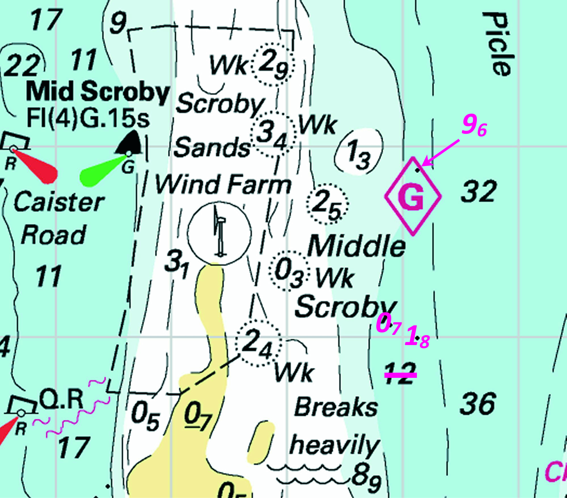


 Fl.Y.5s3M ANS 1 52° 14´·29N., 1° 39´·02E.

 Fl(5)Y.20s (2 buoys) PA


 Fl(4)G.15s NW Holm

 Fl(3)G.10s W Corton
 Q N Holm


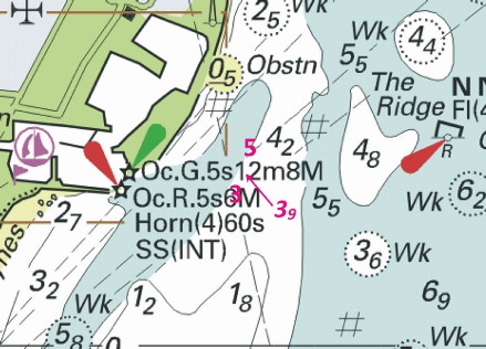


 , joining:


 V
V


 at 52° 14´·49N., 1° 42´·55E.

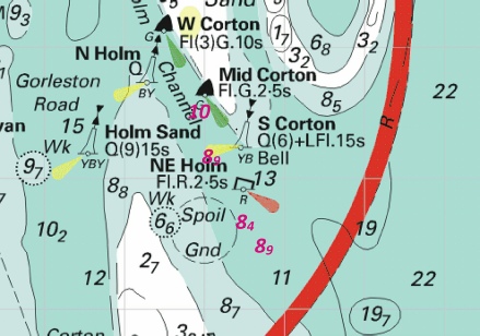


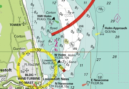
 Q(6)+LFl.15s S Corton Bell
 Fl.R.2·5s NE Holm
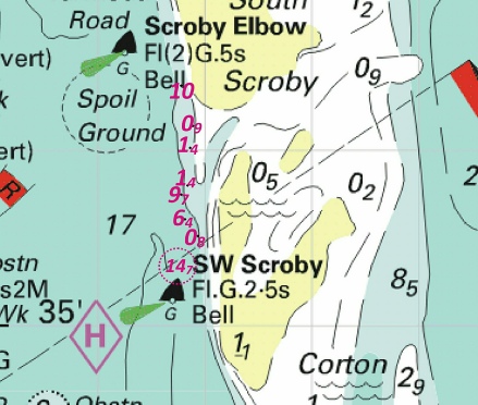
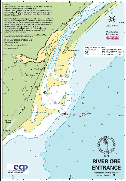
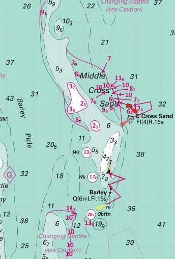


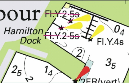
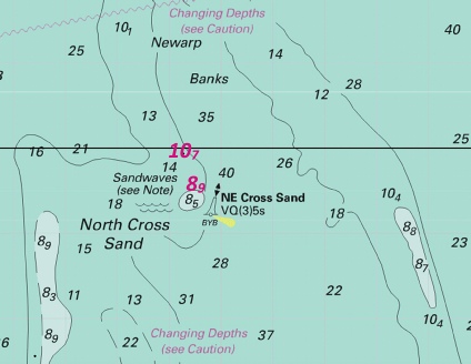


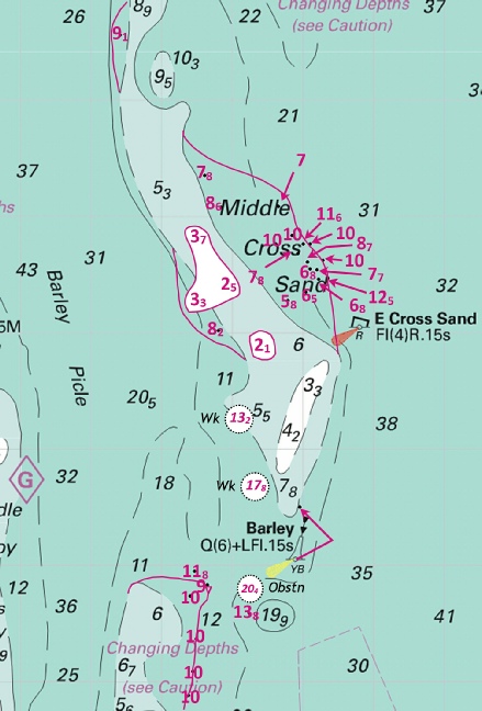


 Q(6)+LFl.15s Barley


 Fl(2)10s
  Fl(2)10s at 52° 12´·87N., 2° 30´·16E.


 Wk
Wk 

 Coast Watch Station at 52° 49´·49N., 1° 31´·95E.


 Q(6)+LFl.15s S Corton Bell
 Fl.R.2·5s NE Holm


 at 52° 18´·25N., 2° 09´·31E.
 at 52° 14´·16N., 2° 15´·16E.
 at
at at 52° 13´·00N., 2° 28´·80E.
 at 52° 15´·52N., 2° 28´·84E.
 at 52° 16´·86N., 2° 23´·60E.
 at 52° 19´·51N., 2° 32´·80E.


 at
at

