|
Notices - |
||
|
Week 16 |
New Editions of ADMIRALTY Small Craft Charts to be published 18 April 2024 SCC 5614.7 A Cromer to Wells- B Wells- New Editions of ADMIRALTY Small Craft Charts to be published 2 May 2024 SCC 5614.8 Outer Approaches to The Wash. 1:150,000 SCC 5614.9 Approaches to The Wash. 1:75,000 |
Includes full updates for New Edition and Notices to Mariners affecting source charts. Includes full updates for New Edition and Notices to Mariners affecting source charts. |
|
Week 10 |
ENGLAND - Delete:
Notice 1076 refers Base image courtesy of Imray ID10 Chart Y9 and Meridian Chartware.
|
Affects: UKHO SNC: 1200, Note: This update is included in New Edition 108, published 22 February 2024. UKHO SCC: 5614.10 (Panel A, The Wash Eastern Part), 5614.11 (Panel A, The Wash Central Part and 5614.9. Imray Full Charts: Y9 The Yellow special lit buoy at the northerly tip of the Roaring Middle shoal in the centre of the Wash is deleted.
|
|
Week 09 |
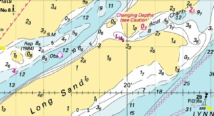
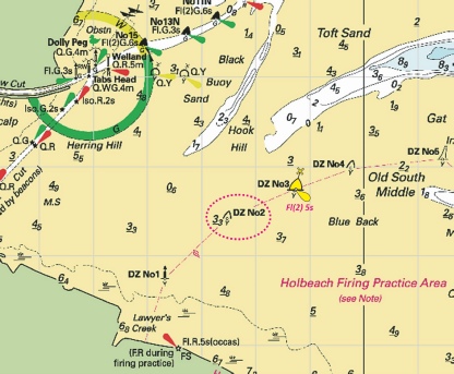
ENGLAND - The unlit buoy, DZ No 2, in position 52° 54´·42N., 0° 07´·48E., is reported missing. Mariners are advised to navigate with caution in the area. Notice 893(T) refers Base image courtesy of Imray ID10 Chart Y9 and Meridian Chartware.
|
Affects: UKHO SNC: 1200. UKHO SCC: 5614.11 (Panel A, The Wash Central Part) [ and 5614.12 (Panel A, The Wash Western Part) Imray Full Charts: Y9 Following on Notice 872 last week which reported the change of top mark (yellow ‘X’) and light characteristics for the DZ3 buoy which marks part of the western side of the Holbeach Firing Practice Area in the Wash, this temporary notice is reporting that the adjacent special yellow buoy DZ2 is missing.
|
|
Week 08 |
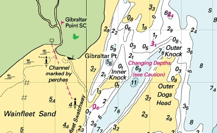
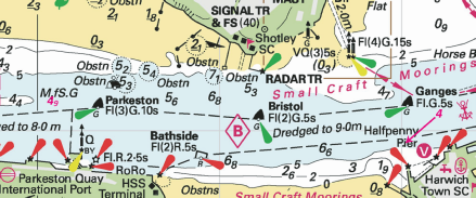
ENGLAND - Delete: Automatic Identification System, AIS, at B1 light- Notice 794 refers Base image courtesy of Imray ID10 Chart IN5043 and Meridian Chartware.
|
Affects: UKHO SNC: 1200 UKHO SCC: 5614.11 and 5614.12 Imray Full Charts: Y9 AIS has been removed from the B1 lit buoy in the Wash. The B1 buoy is a yellow special buoy marking the apex of the shipping anchorage at the approaches to Boston.
|
|
Week 08 |
ENGLAND - Insert: depth, 4.9 , enclosed by 5m contour at 51° 57´·110N., 1° 15´·077E. Replace: depth, 5.3 , with depth, 4 , enclosed by 5m contour at 51° 56´·948N., 1° 17´·011E. Notice 815 refers Base image courtesy of Imray ID10 Chart Y16 and Meridian Chartware.
|
Affects: UKHO SNC: 1491 and 2693 UKHO SCC: 5607.7 Imray Full Charts: Y16 Imray Leisure Folios: 2000.5 Two reductions of depth in the River Stour, one west of the Parkeston starboard hand buoy, the other off the Trinity House Pier. At 4m+ unlikely to hinder leisure craft.
|
|
Week 06 |
New Editions of ADMIRALTY Charts to be published on 22nd February, 2024 Chart 106 England - 1:75,000 Chart 108 England - Wells- |
Includes significant safety- Amendments to depths from the latest British Government surveys. |
|
Week 06 |
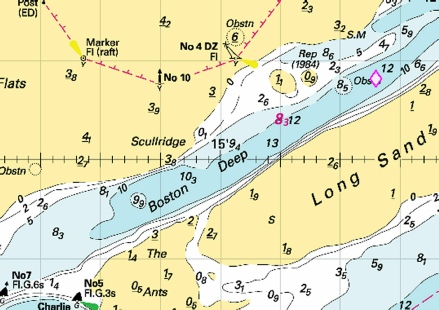
ENGLAND - Replace:
Notice 634 refers Base image courtesy of Imray ID10 Chart Y9 and Meridian Chartware.
|
Affects: UKHO SNC: 1200 UKHO SCC: 5614.10 (Panel A, the Wash Eastern Part) Imray Full Charts: Y9 This notice reports a change of mark in the approaches to Kings Lynn. Beacon ‘B’ was destroyed last year and replaced with a lit yellow special buoy. Now the Beacon ‘B’ has been reinstated as before in lieu of the temporary yellow special buoy.
|
|
SCROLL DOWN FOR PRE- |
||
|
Week 50 |
ENGLAND - The yellow light- 52° 55´·70N., 0° 16´·52E. is reported off station until further notice. Mariners are advised to navigate with caution in the area. Notice 4710(T) refers Base image courtesy of Imray ID10 Chart Y9 and Meridian Chartware.
|
NOTICE: Kings Lynn Conservatory Board have just announced the W1 buoy and AIS has been put back into place. 04/12/23 Affects: UKHO SNC: 108 and 1200 UKHO SCC: 5614.11 and 5614.9 Imray Full Charts: Y9 The yellow light buoy W1 marking the shipping Wisbech and Sutton Bridge anchorage in the Wash is temporarily reported off station.
|
|
Week 26 |
ENGLAND - Amend: fog signal to, Bell, at light- Notice 2115 refers Base image courtesy of Imray ID10 Chart Y9 and Meridian Chartware.
|
Affects: UKHO SNC: 108 and 1190. UKHO SCC: 5614.9 and 5614.8 Imray Full Charts: Y9 The Fog signal for the North Well Safe Water Buoy centrally in the Wash has been changed from Whistle to Bell.
|
|
Week 23 |
New Editions of ADMIRALTY Small Craft Charts to be published 22 June 2023 SCC 5614.10 A The Wash, Eastern Part. 1:37,500 B Continuation of Lynn Cut. 1:37,500 C King's Lynn. 1:10,000 SCC 5614.11 A The Wash, Central Part. 1:37,500 B Continuation of the River Nene. 1:50,000 C Continuation of the River Nene to Wisbech. 1:50,000 SCC 5614.12 A The Wash, Western Part. 1:37,500 B Approaches to Boston. 1:20,000 C Boston. 1:10,000 |
Includes full updates for New Edition and Notices to Mariners affecting source charts. |
|
Week 15 |
New Editions of ADMIRALTY Charts to be published on 27th April, 2023 Chart 1200 - Boston. 1:10,000 Approaches to Boston. 1:20,000 Continuation of the River Nene. 1:50,000 Continuation of the River Nene to Wisbech. 1:50,000 Lynn Cut continued. 1:37,500 Kings Lynn. 1:10,000 |
Includes amendment to lights and depths from the latest Port Authority Surveys. |
|
Week 5 |
ENGLAND - Recent survey information has shown that depths and drying heights less than charted exist within the approaches to the Port of Boston. The most significant are as follows: Depth Position 5·3m 52° 57´·25N., 0° 07´·86E. 3·5m 52° 57´·15N., 0° 07´·86E. 0·6m 52° 56´·73N., 0° 07´·58E. 0·8m 52° 56´·53N., 0° 07´·16E. 0·3m 52° 56´·19N., 0° 05´·36E. 1·2m 52° 56´·14N., 0° 05´·18E. Drying height Position 0·8m 52° 57´·06N., 0° 08´·00E. 0·9m 52° 56´·96N., 0° 07´·81E. 1·9m 52° 56´·88N., 0° 07´·98E. Light characteristics at Tabs Head light in position 52° 56´·01N., 0° 04´·92E.have been amended to Q.4m1M Mariners are advised to navigate with caution in the area. These changes will be included in a New Edition of Charts 1200, 5614.11 and 5614.12 to be published early 2023. Notice 477(P) refers Base image courtesy of Imray ID10 Chart Y9 and Meridian Chartware.
|
Affects: UKHO SNC: 1200 UKHO SCC: 5614.11 and 5614.12 Imray Full Charts: Y9 Preliminary notice providing details of 6 reductions of depth and three new drying heights in and around the channel leading to the New Cut to Boston. The channel is significantly shallow. New charts promised early this year.
|
|
SCROLL DOWN FOR PRE- |
||
|
Week 47 |
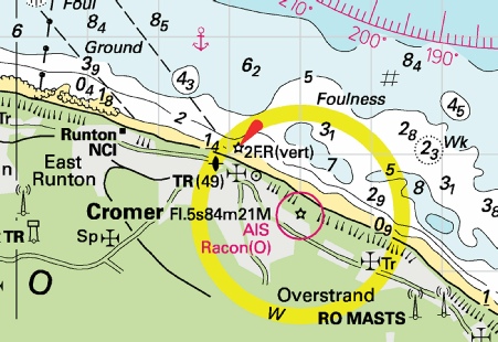
EAST COAST OF ENGLAND - Latitude 52° 55.482’N., Longitude 001° 18.990’E. Racon (ALRS. 51650) Amendment: From 28th November to 4th December 2022, Racon will be unreliable due to maintenance work. No further notice will be given. Notice Trinity House No 40 refers Base image courtesy of Imray ID10 Chart C28 and Meridian Chartware.
|
Affects: UKHO Charts: 1535 and 1543 Imray Charts: C28, C25 A warning from Trinity House that the Racon on the Cromer Lighthouse from 28th November to 4th December 2022, will be unreliable due to maintenance work.
|
|
Week 35 |
New Editions of ADMIRALTY Small Craft Charts to be published on 15th September, 2022 5614.3 Approaches to Lowestoft. 1:25,000 5614.4 A Approaches to Great Yarmouth. 1:25,000 B Great Yarmouth Outer Harbour. 1:7,500 5614.5 A Northern Approaches to Great Yarmouth. 1:25,000 B Great Yarmouth Haven. 1:7,500 5614.20 Whitton Ness to Goole and Keadby and Lowestoft Harbour. 1:6,250 A Lowestoft Harbour. 1:50,000 B Whitton Ness to Goole and Mere Dyke. 1:50,000 C River Trent continuation to Keadby. 1:50,000 |
Includes full updates for New Edition and Notices to Mariners affecting source charts. Includes full updates for New Edition and Notices to Mariners affecting source charts. Includes full updates for New Edition and Notices to Mariners affecting source charts. Includes full updates for New Edition and Notices to Mariners affecting source charts. |
|
Week 21 |
ENGLAND - Delete
Notice 1995 refers Base image courtesy of Imray ID10 Chart Y9 and Meridian Chartware
|
Affects: UKHO Charts: 108 and 1200. UKHO Small Craft Charts: 5614.9, 5614_10 (Panel A, The Wash Eastern Part) and Chart 5614_11 (Panel A, The Wash Central Part) Imray Charts: Y9 Simple deletion of the Z6 Danger Buoy in the Lynn Deeps in the Wash.
|
|
Week 19 |
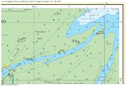
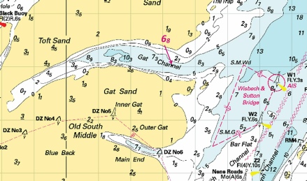
ENGLAND - Insert:
52° 55´·35N., 0° 23´·51E. Delete:
Notice 1762 refers Base image courtesy of Imray ID10 Charts Y9 and Meridian Chartware
|
Affects: UKHO Charts: 108. UKHO Small Craft Charts: 5614.9 Imray Charts: Y9 This notice adds detail to last week’s notice (1642) notifying the buoyage and Pilot details for the approaches to Kings Lynn (changing to the Bulldog channel from Dalesley’s Sled). The image explains.
|
|
Week 18 |
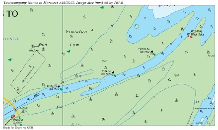
ENGLAND - Insert: the accompanying block, centred on: 52° 54´·0N., 0° 22´·5E. (each for the SNC and the SCC charts)
Delete:
Notice 1642 refers Base image courtesy of Imray ID10 Chart Y9 and Meridian Chartware: UKHO Blocks are copyright of the UKHO.
|
Affects: UKHO Charts: 1200 UKHO Small Craft Charts: 5614.10 (Panel A The Wash, Eastern Part) Imray Charts: Y9 Two UKHO blocks showing the changes to the approaches to Kings Lynn (now preferring the Bulldog Channel): one for the SNC, the other for the SCC. The additional changes are a move of the No 1 yellow special buoy and the associated Kings Lynn Pilot Station at the entrance of the Bulldog Channel.
|
|
Week 17 |
ENGLAND - Insert: limit of spoil ground, pecked line, joining: (a) 52° 58´·81N., 0° 11´·51E. (b) 52° 58´·65N., 0° 11´·49E. (c) 52° 58´·64N., 0° 12´·03E. (d) 52° 58´·80N., 0° 12´·04E. legend, Spoil Ground, within: (a)- Notice 1533 refers Base image courtesy of Imray ID10 Chart Y9 and Meridian Chartware
|
Affects: UKHO Charts: 108, and 1200 UKHO Small Craft Charts: 5614.9 and 5614.11 (Panel A, The Wash Central Part) Imray Charts: Y9 Spoil Ground reported just northeast of the No 7 SHB marking the Freeman Channel to and from Boston.
|
|
Week 14 |
ENGLAND - Replace: Notice 1316 refers Base image courtesy of Imray ID10 Chart Y9 and Meridian Chartware
|
Affects: UKHO Charts: 1200. UKHO Small Craft Charts: 5614.10 Imray Charts: Y9 Beacon ‘B’ in the approaches to Kings Lynn is replaced by a Yellow Special lit buoy.
|
|
Week 10 |
ENGLAND - Chart 5614.12 (Panel B, Approaches to Boston) Insert: the accompanying block, centred on: 52° 56´·6N., 0° 06´·8E. Chart 5614.12 (Panel A, The Wash Western Part) and 5614.11 Insert drying height, 1.2, and extend 0m low water line S to enclose 52° 56´·63N., 0° 07´·22E. Delete depth, 1, close E. drying height, 0.6, and extend 0m low water line N to enclose 52° 56´·35N., 0° 06´·40E. Notice 856 refers Block copyright of the UKHO
|
Affects: UKHO Small Craft Charts: 5614.12 (Panels A and B) and 5614.11 Imray Charts: Y9 Two new drying areas at the entrance channel to Boston. There is a new UKHO Block showing the new areas (which is repeating NTM546 of week 6).
|
|
Week 6 |
ENGLAND - Insert: drying height, 1.2, and extend 0m low water line S to enclose 52° 56´·63N., 0° 07´·22E. Delete depth, 1, close E. drying height 0.6, and extend 0m low water line N to enclose: 52° 56´·35N., 0° 06´·40E. Chart 1200 (INT 1556) (Panel B, Approaches to Boston) Insert: the accompanying block, centred on: 52° 56´·5N., 0° 06´·7E. Notice 546 refers Base image courtesy of Imray ID10 Chart Y9 and Meridian Chartware
|
Affects: UKHO Charts: 1200 and 1200 (Panel B, Approaches to Boston) UKHO Small Craft Charts: 5614.12 Imray Charts: Y9 Two new drying areas at the entrance channel to Boston. There is a new UKHO Block showing the new areas.
|
|
|
Scroll down for pre- |
|
|
Week 43 |
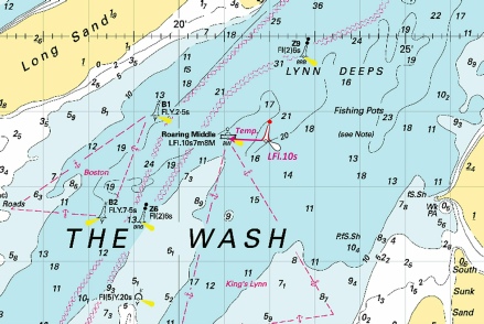
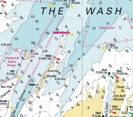
ENGLAND - The Roaring Middle light- Mariners are advised to navigate with caution in the area. Notice 4382(T) refers Base image courtesy of Imray ID10 Chart Y9 and Meridian Chartware
|
Affects: UKHO Charts: 108, 1190 and 1200 Imray Charts: Y9 UKHO Leisure Folios: 5614.9. A safe water buoy temporarily placed in lieu of the Roaring Middle Light Float central in the Wash.
|
|
Week 41 |
ADMIRALTY CHARTS TO BE PUBLISHED 28 OCTOBER 2021 - From the 28th October 2021, Leisure folios will be withdrawn in the current folio format and their replacements will be announced over the following 6 weeks as Small Craft Charts. Between Weeks 43/21 and 48/21, the new Small Craft Charts will be released in batches of around 60 to 90 charts and will result in the current folios being withdrawn for the market. From Week 4, folios will no longer be available to buy, and all new Small Craft Sheets will be available to order via the POD service. Our Website will be updated to reflect this change and contain all additional information. SC5614 - 5614_1 A Orford Ness to Benacre Ness. 1:75,000, B Orford Ness. 1:50,000 5614_2 Lowestoft to Winterton Ness. 1:75,000 5614_3 Approaches to Lowestoft. 1:25,000 5614_4 A Approaches to Great Yarmouth. 1:25,000, Great Yarmouth Outer Harbour. 1:7,500 5614_5 A Northern Approaches to Great Yarmouth. 1:25,000, B Great Yarmouth Haven. 1:7,500 5614_6 A Caister- 5614_7 A Cromer to Wells- 5614_8 Outer Approaches to The Wash. 1:150,000 5614_9 Approaches to The Wash. 1:75,000 5614_10 A The Wash - 5614_11 A The Wash - C Continuation of the River Nene to Wisbech. 1:50,000 5614_12 A The Wash - 5614_13 Gibraltar Point to Saltfleet. 1:75,000 5614_14 Approaches to the River Humber. 1:75,000 5614_15 River Humber Entrance. 1:37,500 5614_16 Spurn Head to Grimsby Middle. 1:25,000 5614_17 A Approaches to Grimsby. 1:25,000, B Grimsby. 1:10,000 5614_18 A Immingham to Saltend. 1:25,000, B Goole. 1:5,000 5614_19 A Kingston Upon Hull to Humber Bridge. 1:25,000, B Humber Bridge to Whitton Ness. 1:50,000, C Hull Docks - 5614_20 Whitton Ness to Goole and Keadby and Lowestoft Harbour. - B Whitton Ness to Goole and Mere Dyke. 1:50,000, C Continuation to Keadby. 1:50,000 5614_21 Spurn Head to Flamborough Head. 1:150,000 5614_22 A Bridlington to Scarborough. 1:75,000, B Bridlington Harbour. 1:5,000 5614_23 A Approaches to Whitby. 1:25,000, B Whitby Harbour. 1:7,500, C Scarborough Bay. 1:10,000, D Scarborough Harbour. 1:5,000 5614_24 Scarborough to Whitby. 1:75,000 5614_25 Southern North Sea. 1:750,000 |
One of a series of new Small Craft charts, replacing the Leisure folios. For the convenience of chart users, the number of the withdrawn folio has been retained for these new charts. All sheets have been fully updated for New Editions and Notice to Mariners affecting source charts. |
|
Week 35 |
New Editions of ADMIRALTY Charts published 16 September 2021 Chart 1200 International Chart Series, England - A Boston. 1:10,000 B Approaches to Boston. 1:20,000 C Continuation of the River Nene. 1:50,000 D Continuation of the River Nene to Wisbech. 1:50,000 E Lynn Cut Continued. 1:10,000 F Kings Lynn. 1:10,000 |
Includes significant safety- |
|
Week 29 |
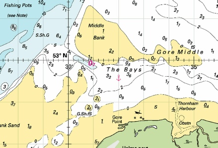
ENGLAND - Insert: depth, 5.9 at 52° 56´·13N., 0° 11´·03E. Delete depth, 8.3, close E. depth, 6.8 at 52° 56´·03N., 0° 13´·28E. Delete depth, 7.3, close NW. depth, 4.7, and extend 5m contour S to enclose 53° 00´·45N., 0° 15´·99E. drying height, 1.1, and extend 0m low water line N to enclose 53° 01´·20N., 0° 19´·67E. Delete depth, 4.5, close SE. drying height, 0.9, enclosed by 0m low water line at 53° 01´·36N., 0° 20´·68E. Delete depth, 0.8, close SE. drying height, 2.1, and extend 0m low water line SE to enclose 53° 01´·82N., 0° 22´·43E. Delete depth, 4.1, and associated 5m contour, close SW. drying height, 0.6, and extend 0m low water line E to enclose 53° 04´·50N., 0° 20´·26E. Delete depth, 1.4, close E. drying height, 3.1, and extend 0m low water line E to enclose 53° 05´·72N., 0° 22´·11E. Delete drying height, 2.4, close W. drying height, 2.8, enclosed by 0m low water line 52° 57´·53N., 0° 26´·03E. depth, 2.3 at 53° 00´·32N., 0° 29´·84E. Delete depth, 4.1, close SE. depth, 1.1, enclosed by 2m contour at 53° 00´·03N., 0° 29´·95E. depth, 0.7, enclosed by 2m contour at 52° 59´·92N., 0° 30´·93E. depth, 1.6, and extend 2m contour E to enclose 52° 59´·51N., 0° 31´·45E. Delete depth, 3.2, close NE. depth, 0.2 at 52° 59´·66N., 0° 35´·67E. Delete depth, 1.4, close E. Replace: depth, 3, with depth, 2.4 at 53° 06´·28N., 0° 22´·65E. Notice 2835 refers Base image courtesy of Imray ID10 Chart Y9 and Meridian Chartware
|
Affects: UKHO Charts: 108 Imray Charts: Y9 UKHO Leisure Folios: 5614.8, 5614.9, 5614.10, 5614.11 and 5614.13. 15 changes of depth in the Wash: 2 in the Gat Channel, 1 in the Boston Deep, 3 (substantial) in the Parlour Channel, 3 off Gibraltar Point, I off the South Sunk Sand and 5 in The Bays.
|
|
Week 28 |
ENGLAND - Recent survey information has shown changes to charted depths and drying heights in the area of Boston Deep, Gat Channel, Wisbech & Sutton Bridge, Wisbech Channel, Wisbech Eye Channel, River Nene and Hunstanton Bays. The most significant depths are: Depths Position 8·3m 53° 00´·41N., 0° 16´·00E. 6·8m 52° 56´·03N., 0° 13´·28E. 0·7m 52° 59´·92N., 0° 30´·93E. These changes will be included in a New Edition of Chart 1200 to be published mid 2021. Notice to Mariners will be issued for Chart 108. Mariners are advised to navigate with caution in the area. (ETRS89 DATUM) Notice 2762(P) refers Base image courtesy of Imray ID10 Chart Y9 and Meridian Chartware
|
Affects: UKHO Charts: 108 and 1200 Imray Charts: Y9 UKHO Leisure Folios: 5614.9, 5614.11. Three reduced individual depths in three entirely separate locations: the Boston Deep, Gat Channel and the Bays.
|
|
Week 11 |
New Editions of ADMIRALTY Charts to be published on 1st April, 2021 Chart 1503 - surveys. 1:150,000 Chart 1504 - 1:150,000 |
Includes changes to the UK fisheries limits and depths from the latest British Government surveys. Includes changes to the UK fisheries limits, wrecks, windfarms and depths from the latest British Government surveys. |
|
Week 1 |
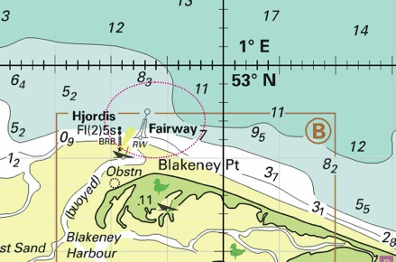
ENGLAND - The safe water buoy ‘Fairway’, in position 52° 59´·23N., 0° 58´·53E. is reported off station. Notice 114(T) refers Base image courtesy of Imray ID10 Chart C28 and Meridian Chartware
|
Affects: UKHO Charts: 108, 1190 and 1503 Imray Charts: C28 UKHO Leisure Folios: 5614.7. As reported by the Blakeney Harbour Association the ‘Fairways’ Buoy has been off station since 14th November, 2020. It is expected to be re-
|


 Fl.Y.2s B
  Fl.Y.2s B at 52° 49´·09N., 0° 21´·14E.
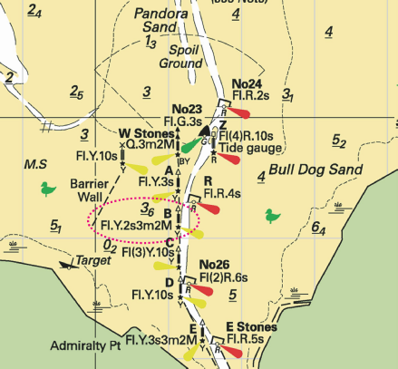


 Fl.Y.3s No 1
  Fl(2).R.6s No 2
 Fl(2)G.6s No 3
  King’s Lynn
  , direction of vessel movement 190° at
 Fl.Y.3s No 1
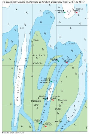


 Fl.Y.2s3m2M B with